
I have no real goal around peak bagging in Death Valley, but something fun just happened, and so now I'm keeping a list. Maybe someday it will become the basis for more.
While @mrs.turbodb and I were enjoying our first Fall 2025 trip to Death Valley, I shared with her that we'd be climbing Funeral Peak on the last day of our adventure. Keen to see what Digonnet had to say about the hike, she pulled up Hiking Death Valley on her Kindle and was surprised to find that the hike wasn't listed at all. However, it did mention (highlight mine):
Home to world-famous Zabriskie Point and spectacular Dante's View, the Black Mountains border the dramatic southern basins of Death Valley, from Furnace Creek Wash to the Amargosa River delta. They are the second lowest in the park - their highest summit, Funeral Peak, is only 6,384 feet high.Hiking Death Valley
This got the wheels turning in my head and after the smoke cleared, I realized that we might be on to something. Back in 2021, we'd ventured into the Owlshead Mountains and summited the Lowest Peak in the Park, before returning only a couple weeks later with a fun idea to reach the top of the Panamints, and the Highest Peak in the Park. Since then, I hadn't really given much thought to high points of the park's ranges, but on hearing that a spot we were planning to go was a third high point, I figured I had better make a list.
So, here are the "top 15" ranges in the park, and their associated high points. Interestingly, this list is different than whatever Digonnet used, since the Black Mountains are not "second lowest," but since I have no real way to contact Michel in order to check what he considered a Mountain Range, I'll be going with this list for now.
| Rank | Range | Summit / Elevation / Coordinates | Trip Report / Story |
|---|---|---|---|
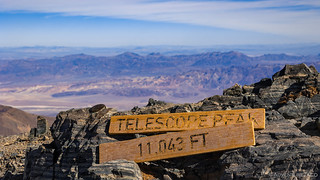
| 1 | Panamint Range | Telescope Peak — 11,043 ft36.1706°N, 117.0890°W | Highest Peak in the Park / Part 3 |
| 2 | Inyo Mountains | Waucoba Mountain — 11,123 ft37.0220°N, 118.0078°W | Sky High / Part 3 |
| 3 | Cottonwood Mountains | Tin Mountain — 8,953 ft36.8870°N, 117.4563°W | |
| 4 | Grapevine Mountains | Grapevine Peak — 8,738 ft36.9653°N, 117.1498°W | |
| 5 | Last Chance Range | Dry Mountain — 8,674 ft36.9088°N, 117.5978°W | |
| 6 | Argus Range | Argus Peak — 6,562, ft35.852°N, -117.448°W | Nadeau Part Deux / Part 1 |
| 7 | Nelson Range | Galena BM — 7,698 ft36.5565°N, 117.6559°W | |
| 8 | Funeral Mountains | Pyramid Peak — 6,703 ft36.1030°N, 116.6237°W | After the Rain / Part 1 |
| 9 | Saline Range | Saline Peak — 6,558 ft36.9513°N, 117.7240°W | Deja Vu / Part 3 |
| 10 | Black Mountains | Funeral Peak — 6,384 ft36.1030°N, 116.6237°W | Back to the Blacks / Part 3 |
| 11 | Slate Range | Slate Range High Point — 5,194 fttbd | |
| 12 | Greenwater Valley Range | Ryan BM — 5,149 ft36.2147°N, 116.5881°W | |
| 13 | Ibex Hills | Ibex Peak — 4,751 ft35.8787°N, 116.4167°W | |
| 14 | Owlshead Mountains | Owl Peak — 4,666 ft35.7312°N, 116.8819°W | Lowest Peak in the Park / Part 2 |
| 15 | Eureka Hills | Eureka Dunes Highpoint — 3,540 fttbd | In Search of Overlooks / Part 1 |
| 16 | Saddle Peak Hills | Ibex BM — 2,561 ft35.7418°N, 116.3394°W |
In No Particular Order
![In Search of Overlooks - A Fall Trip to Western Death Valley [P1]](https://live.staticflickr.com/65535/49072602511_82aa16d541_h.jpg)


 Pyramid Peak | Rain #1")


Hello AdventureTaco!
I'm a big fan of your work; your prose is just as illuminating and illustrative as your wonderful photos.
Anyway, a small quibble here regarding your DEVA peak list. The high point of the Inyo Mtns would be Waucoba Mountain at 11,123'. As like Keynot Peak, the summit of Waucoba is also just outside of the park's boundaries however, and unlike Keynot, it is most often accessed from a trailhead that's inside of the park.
With Best Regards - RT
Thanks! Apparently, when I asked an AI generator for the list, it also didn't know and made something up. Must have been coded by a male human, hahaha.
I'm actually glad to hear that it's Waucoba, since I think that'll be easier to get to from North Pass! Keynot seemed like it could be quite the trek.