
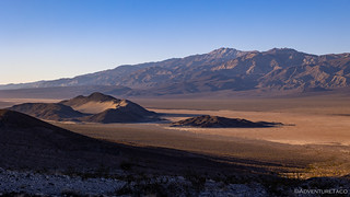
It was shortly after 2:00pm when I arrived at the trailhead for my next destination. Literally parked along the shoulder of CA-190, anyone driving by might surely wonder, "why is a person parked here?"

Like the time of day, to the casual observer, there's nothing remotely remarkable about this place - though with a little knowledge, both the time and place become noteworthy. The time, because I had only a little over two hours - before sunset - to complete a 6-mile hike; the place, because despite the seemingly pedestrian landscape, there existed a double natural bridge and two of the narrowest slot canyons I've ever encountered.
Time to get going!


Despite the unassuming start, the truth is that there was plenty for my senses to soak in as I made good time up the gently sloping terrain. Such it is, I suppose, in a place where nature is so clearly in control. The push and pull between the blazing sun and overwhelming rains evident all around - both small scale and large.


Knowing that my time was limited, I made relatively quick progress for the first couple of miles. This was made easier by following some advice of those much more experienced in these parts. Rather than hiking up the wash, I hiked along the small southern bench above the wash where the rocky surface had been hardened into desert pavement. It was, frankly, some of the most pleasurable hiking I've done on a fan.

Eventually - as the height differential between the bench and wash increased - I abandoned the fabulous terrain and dropped back down into the wash.
At this point I was on the lookout for an element of this hike that really piqued my interest. As I alluded to earlier, Ken @DVExile had explored this area a year earlier, but he'd only recently posted his trip report. In it, he'd shared "the sketchiest chock-stone arrangement [he'd] ever seen," and I was immediately enthralled. The arrangement was so precarious that he and I even contemplated whether it was able to stand up to the flooding that had occurred during the DEVA Deluge nine months after his visit and three months before mine.
There was only one way to know - and that was to go look.

Of course, I was elated to have found the location and I was more than a little amazed to find the two stones still wedged into the fanglomerate. I was also very surprised by the size of the entire situation - it was significantly smaller than I'd envisioned. And by significantly, I mean by a couple orders of magnitude. Not that it made the situation any less wonderous as I set about trying to capture the amazing balancing act from every possible angle.


(No chockstones were touched in the taking of this photo!)
After finding this amazing situation, I must admit that I felt a sense of relief and was much more relaxed - even as my adrenaline was pumping in a few situations - for the remainder of the hike; it's amazing how anticipation and hope can be such powerful influences, even unconsciously.

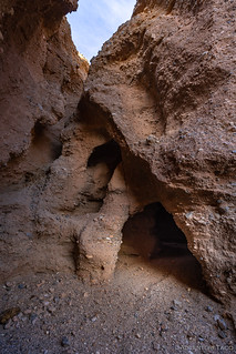
Before I knew it, I'd reached the namesake of this hike - the only known double natural bridge in Death Valley, discovered by one of Death Valley's most prolific hikers in 2016. Like the double chockstone, I knew I was in for a special treat as I approached the formation - not only because of the bridge itself, but also because of the world behind it!
Of course, just as I was photographing the bridge, the low battery indicator on my camera began to flash. This is a situation I've found myself in before, and yet I still have a hard time remembering to pack a second battery when I leave the Tacoma.
And so, with less than 10% of the battery remaining, I shuffled under the bridge and into near darkness - a narrow slot canyon tunneling left and right, sunlight barely able to penetrate the space, the walls more than 50 feet tall.


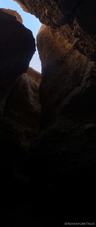
Except for the first 50-feet of the slot canyon, the walls were so close that a normal walk was impossible. Rather, a side-shuffle was the only way through the narrow passages, an experience I would not recommend for those who suffer from claustrophobia; even my adrenaline was elevated by the thought of something going wrong in here.
Eventually, the bottom of the slot gets too narrow to pass, leaving only two options - retrace one's steps to the entrance or climb a few feet up the walls and brace one's arms and legs against the sides and crab-walk, parkour style.


Now at the apex of my excursion, I planned to follow a cross over route to the adjacent wash. Following this wash back down the alluvial fan would spit me out where I'd started and give me entirely new surroundings to explore on the way down.

The highlight of this wash - like the previous - was a narrow slot canyon. In fact, this one was even narrower than the first, aptly named "Squeeze Slot" by those who'd discovered it. In fact, so squeezy was it that I could only make it a dozen feet or so past the mouth before it was too narrow to proceed and I was forced to back out (literally; I couldn't turn around).


By this point, my camera battery had died, and I'd come up with the fabulously terrible workaround of using my cell phone - ironic given that on my very first trip I'd waxed on and on about how cell phone photos were "just as good" as any DSLR, Monte @Blackdawg and Mike @Digiratus assuring me in the nicest way possible that I was wrong.
Sorry guys.
Regardless, it was getting on 4:00pm by this point, and with less than 30 minutes of light remaining, I pointed myself towards CA-190 and made a concerted effort to lay off the photos. Sort of. Unless something cool presented itself. Which I knew would happen constantly.
Like the first wash, the tall walls of ultra-compressed alluvial fan (fanglomerate) were quite intriguing and necessitated a few stops.


This wash also contained quite a few rocks that had extensive inclusions, and though I didn't know how they were caused or really even what they were, I couldn't help but to marvel at the patterns and textures that were formed.


Of course, my slow pace meant that the sun had set by the time I finally reached the Tacoma. Luckily for me, there wasn't much risk of getting lost - as long as I followed the wash, at the very least I'd run into the highway - and my westerly trajectory meant that I was able to enjoy the light show as the sun dropped below the horizon.
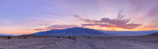

I arrived back at the Tacoma as darkness really began to set in. It'd been an extremely enjoyable excursion and with pleasant temperatures at 31.5 feet above sea level, I decided to make dinner right there along the side of CA-190 before heading west for my final hike along this paved route through the park.
Sitting next to the highway as I enjoyed my guacamole-heavy taco-rittoes, it was fun to watch headlights snake between Furnace Creek and Stovepipe Wells as stars appeared in the sky. Speeding by, these good folks probably wondered what some bozo was doing - parked on the side of the road in a place where there doesn't seem to be much to see - and I'm just fine keeping it that way!

The Following Morning...
I awoke, in an adjacent valley, at 5:00am the following morning.
When I'd arrived - in the pitch dark, though it was only 8:00pm - the night before, I'd intended to camp quite a bit closer to my destination for the morning, but I'd run into a wilderness sign where I hadn't expected to find one. I'd reasoned that the NPS must have closed the remainder of the road to all but foot traffic and so with an extra couple miles to hike, I just set my alarm for a little earlier than I'd initially planned. After all, when you go to bed before 9:00pm, you can pretty much get up any time and still have had plenty of rest!

Walking up the wash, I completely understood why the area had been designated as wilderness*. There was no real road here (anymore), and I figured that the wilderness marker was probably a new addition after the previously mentioned DEVA Deluge of 2022.
* or so I thought.
Still, walking in the wash wasn't difficult, especially once I found an old section of road that climbed out of its banks. By 6:15am, I was out of the wash entirely and climbing up towards the Big Four Mine, views of Panamint Valley stretching out below.

@mrs.turbodb and I had considered exploring the Big Four Mine when we'd hiked the Panamint Dunes on a previous trip, but when we looked up the canyon and didn't see any structures, we - incorrectly - assumed that it wasn't worthwhile. Only later would I discover that we simply didn't look hard enough, and that there was actually quite a bit of cool stuff to check out, if we weren't so darn lazy! 

First located in 1907, the Big Four Mine exploited a small lead-zinc deposit speckled with silver. it witnessed limited activity until it was relocated in 1940 by William Reid, owner of the small resort at Panamint Springs, and work started in 1942. Over the next decade, most of the production came from rich pockets, but there were so few of them that they ran through the patience of several lessees.
In 1944 the property was leased to Elmer Perry, who produced until the following year around 350 tons of ore.
In 1946, then in 1947, two other parties tried their luck, but they shipped less than 30 tons each.
The property was leased again in May 1949, this time to Lee Foreman and William Skinner, who were exploiting the Defense Mine across the valley.
When the Big Four Mine closed down in August 1952, it had generated only 70 tons of lead, 50 tons of zinc, and 1,200 ounces of silver. Hiking Western Death Valley National Park
The trick at the Big Four Mine is to get from the lower level to the middle workings. This is done by scrambling up the hillside (there's no real path as far as I could find) and can be a little nerve racking as you're slightly exposed on the way up, and it's steep and loose on the way down. Regardless, it was most definitely worth it once I peeked over the edge of the ridge to the middle workings.

Naturally, I was most interested in the rail lines as they curved out of the adit, but I forced myself to investigate the rest of the site, lest I completely forget to look at anything else. Naturally, it too turned out to be interesting, with several hundred feet of forked tunnels and braced diggings.


With the sun just sneaking over the horizon as I exited the shaft, I tried to find the perfect angle to photograph the ore chute and curved rails as they exited the main digging. I don't feel like I succeeded with either, but it was still a fun feeling to poke around a space like this. In fact, I didn't know that the time, but I'd see another similar setup just 10 days later when I was back in the park to explore the Eastern Inyo's.


By the time I was done, it was nearly 7:00am, and with a long northerly drive scheduled for the remainder of the day (and most of the night), it was time to hoof it back down to the Tacoma and back onto the only road I'd followed for this series of hikes - CA-190.
From the mine, I headed down the segment of road I'd found as I hiked up the wash, the views of Panamint Valley glowing orange below. Caught up in the sights, I didn't even notice - at first - that I seemed to be taking a different route down the canyon than the one I'd used before sunrise. The road - it seemed - continued next to the wash, not only making for an easier hike, but also for an embarrassed hiker.
In fact, as I got back to the Tacoma - completely on the road, mind you - I realized that the wilderness sign I'd seen the night before, and hiked past earlier this morning, was simply to keep people from driving into the wash and off of the main route. However, because the main route made a sharp 90° turn - crossing another nearby wash - I hadn't noticed it, and just assumed I'd reached the end of the road.

It was, I assure you, a moment I was glad to be alone, and I chuckled that perhaps Digonnet - author of the Hiking Death Valley books - has himself experienced. Naturally, he'd cover up such an event with some witty statement like, "Rather than drive the rough road, hike through this playground - where rocks go wandering while no one is watching - and enjoy the spectacular stripes on the mountains of this unnamed canyon."

The drive home was a long one, though the weather was great and traffic didn't give me any problems. It'd been another fantastic trip to the desert, and I already had plans for my imminent return.


There's so much more to DV than I'd ever imagined! And you keep finding MORE for us to enjoy!
Really, I haven't even scratched the surface. As our largest National Park, I could probably live there and still never get to see even half of what it has to offer...
Love your blogs.
Thanks, glad you're enjoying them! Always nice to hear when folks do! ?
I'm still curious about the "miniature bread loaves" and how those came to be. The formations just really make our time here minute when compare to the time it has taken to shape them.
I'm all ears if you figure out how they are formed!