
It was a little before 2:00pm when I rejoined the main road through Mason Valley and headed north. I wasn't sure how far I'd get, but the views were great and though I wished for a little more blue sky, I really had no complaints as I crested a hill near the southern end of the valley, a grove of cottonwoods following the creek, below.

Into the mountains.

Always fun to zoom in and compress the background a little bit in situations like this.

Apparently, I took a lot of photos here.
A few minutes later I was driving into the grove of cottonwoods and feeling like I'd driven into Colorado's the high elevation stands of aspen. The colors were fabulously brilliant, and the blue skies I'd been hoping for were suddenly overhead. Even though I felt like I was in a bit of a rush, I couldn't help but to get out and enjoy the golden glow.

When every leaf is a flower.

Road narrows.
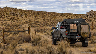
For a while, I wound along next to the creek - sometimes on one side, sometimes on the other - making good time on the nicely graded East Walker Rd. Eventually though, the river meandered its own direction and I was once again in the sage-covered basin and range that makes up so much of Nevada's landscape. It was here that I passed through one of the few fences I'd find across my route.
I much prefer the pace of ungraded roads.

Given the state of the barbed wire, I'd say there's a good chance not many cattle roam this way anymore.
The road along this section of the route was full of whoops, and I had a good time pushing the suspension - which I'd recently rebuilt (see Revalving My Suspension) - a bit to see if the new seals, oil, and shim stacks - made for a better ride. Now, I'll be the first to admit that I'm no expert, but it seems to me that the new shim stacks that I'd gotten from Tim @TMFF were certainly doing what I'd requested - allowing the truck to soak up the uneven terrain. To my feel, both the compression and rebound of the shocks was slower than before, reducing the down-up-down-up-down-up to more of a down-up-down-up.
After several minutes of high-speed fun, I noticed an old stone building on a small offshoot and pulled over to take a look.

Lonely old storage building framed by Mt. Grant in the distance.

The current resident. I was shocked by how blue the top of this western fence lizard was, as opposed to the more common coloring where blue is only on the belly.

Don't you try to sneak up on me. (Note how some of the blue turns to green from this angle.)

One of the things I always like about old buildings is that the placement and orientation often seem more thought-through than modern day structures. Doors and windows almost always frame a nice view.
My stop was brief, and soon I was once again heading into the mountains - an unnamed mine, my next destination. Climbing from 4500' to a little over 7200' over the course of just more than a mile, I soon found myself on a platform, with a relatively well-preserved 5-stamp mill cascading down the steep slope. I'd reached the ██████████ mine.
Perched over the valley.

There wasn't much else at this site, but the mill was fun to explore.

A belt would turn the wooden wheel, which in turn caused the cams to raise and then drop each of the five stamps.

Built a few hundred miles away, over 115 years ago!

Looking down from the top level.
I wandered a few of the nearby spurs, looking for more mining paraphernalia. In the end, I was surprised to not find much else - the rest of the camp clearly "cleaned out" after it was decommissioned - since I figured that the mill was likely one of the more valuable pieces of equipment, but was left to rot.
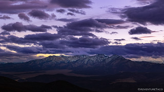
Satisfied that I'd seen what there was to see here, and a little worried by the clouds that were once again gathering overhead, I set my sights on the next stop along my route - the summit of Bald Mountain in the Wassuk Range.
Whereas my previous climb into the mountains - to investigate the mine - had taken me a mere half-mile higher, the climb up Bald Mountain rose nearly a mile - some of it quite steep - and topped out at 9186', nearly a mile above where I'd started.

I was high enough that there were patches of snow on - and beside - the road.

Microwave radio towers transmitting into the distance.

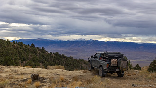
Just over the ridge, and a mile below, Walker Lake.

To the south, the snowy top of Mt. Grant.
It was windy at the top - or at least, windier than I'd experienced earlier in the day. And cold - a good 30°F cooler than at the bottom of the valley. These two things easily explained the rain/snow mix that started falling as I made my way back to the Tacoma, hoping that the weather would blow through quickly - so I could enjoy the remainder of my trip!

Starting my descent into an afternoon storm - hopefully not a sign of things to come.
As is so often the case, I made quick time down the mountain. For me, this is more a result of not stopping for as many photos - the photos having been taken on the way up - as any benefit offered by gravity. From Bald Mountain I continued north - for a bit - before making a 180 degree turn and heading in the opposite direction, albeit eight miles west, in the adjacent Smith Valley.

Even in the intermittent rain, I couldn't help but to stop. Boys and their toys, amiright? 

A most colorful grove.
As I headed south, the storm that'd blown in from the west now in my side view mirrors, a much more welcome - though still partly cloudy - filled my windshield, and my tires once again began to kick up dust in the road. The clouds would come and go for the remainder of the afternoon and evening, but for now, my views of Mt. Patterson to the south, and of wispy clouds to the west, left me energized for the next segment of my adventure.

I'd originally hoped to summit Mt. Patterson, but with snow at elevation, it wasn't looking like that would be in the cards on this trip.
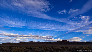
I've never seen formations like this before. I think the horizontal lines are contrails, but the perpendicular combs were fantastic.
I'd gotten a tip from @Y2KBaja that the road (FR-192) up to the KSVL transmitter in the Pine Grove Hills - and especially the two-track connector (actually a combination of FR-22814, FR-42371, and FR-42216) to another Bald Mountain, was a great trail, and so I'd mapped it out along with a few side routes - in the hopes that I'd stumble on some old cabins or mining operations as I explored.

A rocky ascent. Parts were steep and loose enough that I even switched on the rear locker for a couple of sections.
KSVL transmitter in sight. And once again - a dusting of snow on the ground.
I arrived at the top of the mountain a few minutes before sunset - and just a hair after 6:00pm. It was perfect timing, really. One of my favorite things to do is camp on the top of a mountain or ridge, and I hoped that there'd be a nice site somewhere below the towers where I could deploy the tent to hole up for the night. First though, I wanted to have a look around at the top.

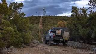
Some towers over there.

Another one over here.
The entire summit was covered by towers and their support buildings. Generators were chugging away - whether actually supplying power or simply self-testing, I wasn't sure - making for a rather inhospitable camp environment. The views though - as the sky to the west took on a purple hue - were exactly what I was looking for.
Looking into California's Sweetwater Mountains, and once again, Mt. Patterson.
A little bummed that I wasn't going to be able to camp on the top of the mountain, I figured that I'd surely find something within a mile or two - even if it didn't have quite such a commanding view - that I could call home for the evening. My biggest concern, really, was that it looked like it could rain again, and I didn't really want to get stuck on some muddy roads out here in the middle of nowhere.

Heading down the south side of the mountain. @Y2KBaja was right - some great views here!
Not far down the road, I came to a four-way junction. Besides the road I'd travelled, one fork would take me back to the Smith Valley, another would shuffle me along the route I'd planned to Bald Mountain (the second summit of the trip with that name), and the last would take me... well, I had no idea.
So that's the one I took.
Within another half mile, I was quite sure that I'd made the perfect decision. Climbing back up on the ridge, the road led to a wide-open area with expansive views to both the east and west, and then petered out. There was no fire ring or other indication of previous campers - a surprise to me given the views - but I wasn't complaining. with the last of the evening light I quickly deployed the tent and snapped a few photos before putting the camera away for the night.

As I looked out at Mt. Patterson, I found myself wondering how far I'd make it the next day, or if I'd even give it a try. There sure did seem to be a lot of snow up there, and this was most definitely the dry side!
Dinner - a simple affair since I was on this adventure alone - consisted of a couple hot dogs, some cool water, and an apple for dessert, all of it eaten while standing in front of the stove - my butt already having gotten enough seat time in the previous 48 hours.
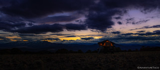
Before heading into the tent, I pulled out the camera for one final shot
It had been a full - but rewarding - first day of exploration. As I snuggled under my comforters in the tent - the wind picking up a bit, but only to 10-15mph, nothing too bad - I wondered if the rest of the trip would go just as well or if I was in for a rude awakening the next morning.
The weather channel on the ham radio had warned of a big storm on the way - 50+ mph winds, and many inches of rain. The only question was: when would it hit?


Once again beautiful photos with some wonderful sights and places. Hopefully no mud in the forecast and some sunshine. A local guy in Hawthorne once told me it is believed that an underground tunnel through the rocks went from Pyramid Lake to Walker Lake, bringing the Lahontan lake trout. I have read some interesting stories about Walker Lake and its history.
Happy Trails!
Wow, I am jealous 🙂 Thanks for sharing your adventure.
Thanks Warren, glad to hear you enjoyed it!?
Hey! You got my attention with that 5 stamp mill. Looks like you were near ████████ but I'm not familiar with that site. I've been researching but now it's bugging the heck out of me!
Unless you crossed to the west side... but I'm still stumped. 🙂
Oh, duh. ██████████. I was convinced that was too obvious and too well known. Nice move not photographing the tanks.