
When visiting rock art and ruin sites, be respectful.
This is most easily done by following the Leave No Trace principles; leaving the place exactly as you found it and taking with you only photographs and memories. In case that is not clear enough for some reason, here are examples of respectful behaviors:
It should have been obvious based on how long it'd taken us to get to camp the previous evening, but by the time we'd checked out a couple of pictograph sites and retraced our route along the Coral Pink Sand Dunes, it was noon when we pulled into the shade of a tree for lunch, and almost 1:00pm by the time we were done making - and consuming - our tuna sandwiches.
There was no way we were going to have time for an hour drive, and then a 14-mile hike through a slot canyon before the sun set just before 7:00pm. And that meant that my yet-to-do-anything-as-I-planned itinerary was still batting 1.000!
Knowing that we'd be starting the next morning's hike well before sunrise, we looked to see if there was anything we could find along the way to the trailhead, and a few minutes later we were headed east on US-89A, through the fire-scarred hillsides of the North Rim of the Grand Canyon, to the edge of the brilliantly red Vermilion Cliffs.

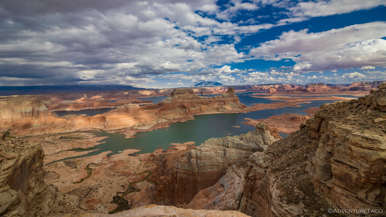
There's a paved overlook of the Vermilion Cliffs, but this one is so much more "poser."
Our afternoon destination was along the face of those cliffs, where there was - impossible as it may seem - a hikeable trail to the top. I'd gotten wind of this place as I perused one of Randy's trip reports, his usual location hints and obfuscations leaving me hopefully optimistic that I knew where I was going.
It was just before 3:00pm when I parked the Tacoma and gazed up at the how-is-there-possibly-a-trail-to-the-top wall that stretched as far as the eye could see in either direction. If there was, it led 2,500 feet higher than our current elevation, and still feeling under the weather, @mrs.turbodb quickly opted out of the colossal effort that was obviously in front of above us.

Cowboy cabin.
Shoving my camera gear, inReach, and a radio - so I could keep my companion updated with my progress - into my little hip pack, I was off. The entire hike - or at least the climb up and back - clocked in at only about 5 miles, a distance I figured I could cover with no water at all, though I also lugged along a single CamelBak, just in case.
From the cabin, the trail headed off to the north-northeast with a sense of purpose. An old road, it's hard to miss unless you’re actively distracted - by say, taking photos of the amazing scenery below the Vermilion Cliffs - which I would know nothing about.

Gray hills that look like they gave up on being mountains and settled for being “lumpy.”

This guy was tiny - his head+body only about 1.5 inches long - but he assured me, still a ferocious dinosaur. (Western side-blotched lizard)
Through the gray hills, it was less obvious where to go, though it turned out that straight - toward a patch of greenery that I determined to be a rather disappointing spring - was the answer. There, the trail veered up a loose, steep slope before hugging a ridge like it was trying to impress someone.

Someone was impressed.
There was also a generous helping of sand - enough to make me question my life choices - and for every step forward, I slid back about half a step; perfect if I'd been feeling like a 2,500-foot climb wasn't quite high enough.

Halfway there.
Halfway up, I ran into a group of 18 Road Scholars - and their guide - who'd arrived at a much more reasonable time and were now on their way down. Hoping that they'd seen the rock art that had inspired this climb, I whipped out my pocket mainframe, flipped the screen their direction, and tried to keep a smile on my face as they showed absolutely no recognition of the carvings.
Dang.
We bid each other happy trails, and I kept climbing.

I had to climb up through this narrow crack.
I never did find the petroglyphs I was looking for, but I did find a lot of other art carved into the patinaed walls as I made my way to the top. Likely, this means I misinterpreted the clues in Randy's trip report - something I'm remarkably good at - and that I'll need to return to investigate another nearby location that could be "the one" in the future!

Mostly waving "hi."

Watermelon man.

Anthropomorphs.

Who's chasing who?

Deer hunt.


High designs.

With and without tail.

Three sheep.
In addition to the older rock art, some more modern signatures - and some very modern defacement/graffiti - decorated the sandstone. I know exactly how to feel about the most modern scratches from those who can't show the smallest amount of respect for these special places, but I'm not sure how to feel about the mid-century modern signatures.


Spence, 1941, Rocking K | FM, 1941, YE
Even stopping for photos - and a couple of detours - along the way, I reached the top in 90 minutes, leaving myself ample time to wander around on the Paria Plateau in search of the petroglyphs that'd inspired this whole endeavor. In fact, after another 90 minutes of searching, I found a total of zero more petroglyphs!

Melting tree.
Knowing that it'd be much more pleasant to make the steep descent before dark, I pulled myself back toward the sandy crack in the cliff and commenced the downward dash toward the Tacoma.

Quite a view.
I'd arrive a few minutes after sunset, to a ready-to-go camp kitchen and hot dogs waiting to be grilled. As I related the story of the afternoon to @mrs.turbodb - much of which she already knew from chatting with the Road Scholars as they'd returned a couple hours earlier - we began to lay out our plan for the following morning.
Our plan, to see the Tower of Silence.
The Whole Story


Beautiful again.
So this trip took some prep.
I look at Randy website , this is a gold mine for this area hiking trips. This make us wanting to rent a place in Kanab for 3 months to explore this area.
I read that you were in Death valley last week, you choose the right week, looks like the temps was warmer than the week before ( the week we were there. )
we have an electric blanket and never do campfires, we have a 8'' metal pot and bring some wood ; what is your heating choice?
Cheers
Randy's site is great, but he gives very few clues as to where he hikes and/or finds the amazing things that he sees; just a word of warning before you set sail for Kanab. 😉
(Of course, that's even apparent on this particular hike, since I never found the rock art I was looking for - likely because it was somewhere else!)
Death Valley was great. Warm weather or not, we love it there during the winter (and hiking during the day is a bit better when it's cooler). Camp fires aren't allowed at all (except in campgrounds) in DVNP, though we never do them regardless since they just make everything smell like campfire forever. Our "stay warm" regime includes puffy coats, electric socks (which are amazingly good), and getting in bed (under two down comforters) shortly after dark.
Had time to read all of the trip report from wet trails with shiny rocks to a whoops with the flying camera, this was a great read! What is next now that the seasons have gone from pleasant to cold? Have a great Christmas!!
Glad you got through the trip so far Bill! There's one more day coming (tomorrow/Wednesday) for this one (to a place called the "Tower of Silence") and then we're off to warmer pastures. Or deserts as it were. Hoping to get a bunch of time in Death Valley this winter, and also hoping that the roads there - which have been impacted by flash flooding - get opened to allow more access.
Merry Christmas to you as well, hope you're having a wonderful holiday season! ⭐🎄
As a young and ignorant man, almost 50 years ago I carved my initials on a rock in what is now Vermillion Cliffs National Monument. Soon they will be protected, for better or worse!