
I was two days late - at least according to Ben @m3bassman - when I rolled into the camp site they'd found just outside Capitol Reef National Park. As usual, the first order of business was a round of hellos with Mike @Digiratus and Zane @Speedytech7, followed by some good-natured ribbing. It was Zane, as I recall, that predicted my arrival time most correctly - at least according to The Price is Right rules that we all seemed to disagree on - and it was Mike who grinned a big I told you so, when I moved my truck into the exact spot he'd told the rest of the guys that I would park for the night.
That one was obvious though, it was the only "edge-of-the-cliff" spot around. 
Of course, I had to meet Ben's new girlfriend - █████ - and the three doggos they'd brought along, all while getting peppered with questions along the lines of, "How many avocados did you bring?" and "What time do you think Monte will show up?"
It was as if we'd never parted ways at the end of our last trip, and it was fabulous.

Zane with Ben's newest addition, Bardie.
Slow down buddy...
I'm already way ahead of myself. Technically, I was two days late, at least based on when these three buddies had started the trip. They'd met up on the edge of the San Rafael Swell and putzed around waiting for Monte @Blackdawg and I to show up. No one was quite sure who would arrive last, but Monte had work, and my 9-hour drive - after landing in Las Vegas to pick up the Tacoma - was made longer by my desire to see a few things On the Way.
After having visited a few petroglyph sites and having consumed a brunch that left me full for the remainder of the day, I still wasn't in any rush to get to camp. It was 6:00pm as I entered Capitol Reef National Park.

This had to be one of the more dramatic entrances to a park that I've experienced.

The official boundary, with the Henry Mountains snowcapped in the distance.
That I was in no rush was a good thing because - as I neared the turn from UT-24 to Notom Rd. - I noticed a sign indicating the existence of more petroglyphs not far away! Pulling into the parking area, I grabbed my camera and binoculars and wandered along the boardwalks that keep pesky tourists - more interested in their instagram feeds than in Leave No Trace - from getting too close to the ancient graffiti.

The light - streaming in under the clouds - was really putting on a show.

Two dudes and their sheep.

I liked how the water and light seemed to fade out the rear half of this sheep.
My Southern Paiute ancestors were roaming and hunting the canyons south of here when white settlers arrived in the 1880s. Long before the Mormon Pioneer, or any tribal memory, other Native American peoples came to know the canyons and cliffs of the Waterpocket Fold. We call them the Fremont Culture, because we don't know what they called themselves. Unlike my own ancestors, the Fremont people did not move with the changing seasons. They took root in these watered canyons and became farmers as well as hunter-gatherers. They left few signs, even though they lived here longer than the five centuries between the voyage of Columbus and the present day.
High on the wall, the old and new, side by side.
James A. Cook, Apr. 9, 1911
Maxie Cook, Nov 1945Other people like them lived over the large portion of what is today called Utah. For the most part, the story of the Fremont people can be told only in questions, not answers. How closely these people are related to the better-known pueblo-building Anasazi, no one knows. There are striking differences, as well as similarities. Many archeologists think that Fremont people may be descended directly from ancient nomads called the Desert Archaic. We know a little about the Fremont people's daily lives from collections of precious artifacts, and something about their hearts and minds from their petroglyphs. We know less, almost nothing, about where they came from or why they left suddenly in the 13th century.
For park visitors, some Fremont Culture petroglyphs can be viewed easily. Caution must always rule in the interpretation of petroglyphs. With few exceptions, we cannot really be sure what the ancient maker of the petroglyphs had in mind. Among serious students, there are some who consider almost all petroglyphs a form of writing, while others consider most of them to be art, not writing. The large trapezoid-shaped human figures excite interest. Many have headgear and horns. Figures are commonly see with necklaces, earrings and sashes. Animals, especially bighorn sheep, appear in many petroglyphs, and indications are that they were once often hunted and perhaps revered.
Procession of sheep.
Following the disappearance of the Fremont people in the 13th century, no one resided in the Waterpocket Fold country for 500 years. During this time, however, Ute and Southern Paiute hunters and gatherers roamed the region, lived in close harmony with the natural environment, and left little evidence of their presence. Here in the Fremont River Valley, archeologists first identified the Fremont Culture. As you walk these paths and hidden places, do not touch the petroglyphs. Protect their legacy, even as I respect it.
Rick Pickyavit (information sign)


Fruita panel.
An hour later - now nearly 7:00pm and only 45 minutes before sunset, I headed south. I'd expected the road here to be dirt, but finding it to be pavement I made good time toward the location Ben had texted earlier in the day.

Newly surfaced.

South through the Waterpocket Fold.

I finally turned east, the Henry Mountains a reminder that winter wasn't completely ready to let spring take over.
So here we are...
Our greetings complete, it was time to enjoy the already burning campfire and sample some of the salsa Mike had made - as usual - for us to enjoy over the course of the next week. There was also - unexpectedly - a few chipfulls of guacamole left that I quickly scarfed down, wondering aloud how everyone could have been so rude as to not leave more. We were off to a great start!

The gang.

"What do you mean, 'are you eating dirt gain'?"
As I alluded to earlier, talk quickly turned to the dire avocado situation, which I was - unfortunately - going to be of little help with until later in the week. I'd picked up seven of the tasty orbs, but they were still rock hard and very green. Luckily, Mike still had two avocados remaining, but after that - I was informed - salsa alone would have to suffice. The horror.

Just before hitting the horizon, the sun illuminated the wall of a nearby mesa and I knew where to put the Tacoma for the evening.
As the light dimmed in the sky, we all wondered to the whereabouts of Monte. Eventually, realizing that he had cell service, Ben fired off a text. Expecting that it'd be only an hour or so before our group was complete, we were all surprised to hear that Monte was still in Salt Lake City - some 3-5 hours, depending on who was behind the wheel - from our location! He'd certainly be arriving after we were all asleep, and the only question that remained was whether we'd get out of bed when he arrived or just wait until morning to say hello.
The following morning...
"Quiet Birdie!" Monte yelled, as he pounded on the cab of his Tacoma, hoping that the newest doggo edition to his family had somehow learned English during the night. And with that, it was time to start the day.

The Redhead in camp mode.
Even with the K9-alarm, we wouldn't get an early start. Monte had pulled in between 1:00 - 2:00am, and if anyone got up to say hi, it wasn't me. (Ben might have, but after waking up for a minute, I quickly fell back asleep, so I'm not totally sure.) At any rate, greetings and ribbings consumed a good 45 minutes, but eventually we all settled into our morning routines. By 10:00am, we were rolling out of camp; south, toward the Burr Trail. Well, Ben was off - the rest of us gave him a bit of a head start, knowing that there wasn't enough time in the day for his lumbering van to get too far ahead of the Tacomas.

Off we go.

Winding south through the heart of Capitol Reef.

The landscape here reminded me of Butler Wash and Comb Ridge.

A deja-view. 

Swap Canyon mesa.
Mike and Zane - less interested in taking photos every few hundred feet - had reigned in Ben's Van within moments of hitting the trail. Monte and I - preferring to stay out of the dust, and willing to stop for just about any reason to snap a few shots and shoot the shit - eventually caught up, just as the group was staging to climb the infamous switchbacks of the Burr Trail.

A familiar lineup.

Double rainbow of rocks and Tacomas.

It may seem an impossibility, but there's a reasonably chill road up through that kalediscope.
Soon enough it was time to climb, but before we'd even covered a quarter mile, the two green trucks were stopped again. It was a large, vertical wall that caused the slowdown this time; drawing us like moths toward the reflected light. It also seemed like the perfect spot for a bit of rock art, and sure enough there were a few small pictographs inconspicuously hanging a dozen feet up on the wall.

Towering shade.

Easy to miss.
By they time we were back in our trucks, everyone else was already at the top. After radioing that we were finally on our way, we climbed the switchbacks slowly, enjoying the expanding view as we gained elevation.

Green Tacomas always have lots of fans. (Pebbles)

An easy climb.

Into the passageway.

Headed up.

Henry Mountain view.
Rendevousing at the top of the switchbacks, we had a decision to make. A few minutes before noon, wherever we ended up, several of us had stomachs ready for sustinence. Rolling the dice, we first chose a road leading south along Capital Reef's upper plateau, only to discover that a few hundred feet ahead, the road was gone; reclaimed by nature. That only left the northern route, and soon we were working our way under a series of arches and double-arches on our way toward the Strike Valley Overlook.

Twinsies.

Sandstone anticline.

I wasn't able to discover the name of this arch at the entrance to Upper Muley Twist Canyon.


Cheerios Double Arch was hard to see, and we had to get right up under it to see two bits of peek-a-blue.
After a leisurely lunch - made so much better by the shade provided by the 10x10-foot canopy that Monte popped up for us in the parking area - it was time for the only hike of the trip. At a little under a mile roundtrip, it'd take us to an overlook of Strike Valley, allowing majestic views of the backbone that runs through Capitol Reef.


The trail was easy enough to follow across the orange Wingate and white Navajo Sandstone, but also easy enough to lose if we didn't pay attention as we crossed the slickrock.
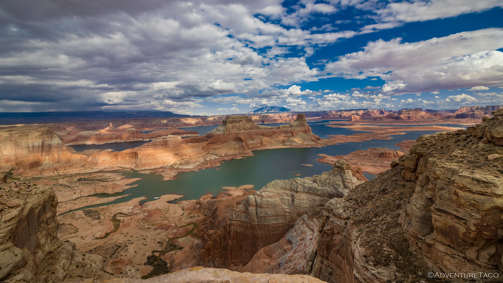
Strike Valley is not named because of a mining boom that struck the valley. It is, instead, named for the geological feature where a valley runs parallel to the strike of underlying rocks in the region. From the overlook, we admired the nearly 100-mile long valley, each side lined by cliffs - Waterpocket Fold to the west and rugged cliffs that make up the badlands to the east - a an impressive backbone running down the center.

An amazing view north.

And "is this even real?" to the south.

Sorry Ben, Maria wore that top better.
After spending a few minutes admiring the view, those with pups waiting for them at the trailhead were antsy to get going, so we hightailed it back to find the pups just fine and Mike definitely not napping. Then, it was back into the trucks as we retraced our path to the Burr Trail, and ultimately, to camp.

Wingate wall.

Getting the shot.

The shot.

I loved how from this spot on the trail, we could see Wingate Sandstone, Navajo Sandstone, Badlands, and the Henry Mountains, all in one place!
Of course, getting to camp at 3:30pm was foriegn to say the least. It was this group of guys that taught me to push on into the darkness, covering as much ground as possible, photographing everything along the way. That mentality has surely changed over the years - to different extents for each of us - but with four hours of daylight left, half the group decided to do a little wheeled-exploration, hoping to find our way to an overlook or two before returning to camp.
Unfortunately, the routes we'd planned to said overlooks were no longer. Or at least, they were no longer drivable, carsonite BLM posts notifying us that no motor vehicles were allowed while site restoration was in progress. And, from the looks of things, that site restoration began decades ago!
We had no choice but to head back and setup camp. Not that we were complaining about the guacamole to come!


Privacy parking.

An nice old dugout from the Hope Uranium Prospect.
Despite the sun still being high in the sky and the solar panel pumping out plenty of Ah to keep the fridge humming along in the afternoon heat, it wasn't long before we had the ring-less camp fire going and several packages of hot dogs were deployed over the flames.


It was quite the effort to get a shot of Mike. (left) | Zane's hotdogs were much less shy of the camera. (right)
I'm not sure exactly how long we stayed up, but with a million bundles of wood and a fire that - ring-less - put off more heat that usual, it was reasonably late when we all wandered back to our tents to call it a night. We hadn't traveled far - less than 40 miles - but the weather had cooperated and it'd been a fantastic time on the trail. Plus, we'd more than make up for the lack of distance tomorrow!
The Whole Story


Looks like a great trip. Your pictures are awesome!! What is your camera and lens set up??
Thanks Brian, glad you enjoyed them! My camera and lens info is covered here:
Shout if you have questions!
Beautiful images of my favorite national park! Thirty one years ago my husband ( a geologist) and I walked to the summits of Mt Ellen and Ellen Peak in the Henry Mountains, the last range, known as the "Unknowns," in the contiguous USA to be mapped by the USGS due to their remote location. No one out there back then. Happy he dragged me up there, oh so many years ago. Such a wonderful write-up! Thanks for the lovely memories.
So glad you enjoyed it Wynne! Capitol Reef really is an amazing place. I'd been through once before - about six years ago at the tail end of a trip that started on the North Rim of the Grand Canyon - but it was nice to see it under much better conditions.
We'd hoped to make it into the Henry's on that first trip, and again hoped to make it this time (but didn't, again). A great reason to return, in my opinion!
Great Photos!
Thanks Tom!
Another great photo essay!
And timely: a couple of days ago I was attempting to describe to my bride some of the places we will travel through on our planned Colorado Plateau trip this Fall, Capitol Reef being one of them. You just provided photographic evidence of why we need to go there. Thank you!
Avocados... as I may have mentioned before, it's my studied opinion that they should be free- the inevitable consequence of having grown up surrounded by Hass trees and neighbors practically begging us to take some off their hands. You will almost always find a few ripening in the fruit bowl on our kitchen counter. I was worried that the price was going to skyrocket due to some recent economic/political events but so far they are holding steady.
Looks like Pliny The Elder showed up in camp. And judging from the hoodie that Mike is wearing in the last photo I'm guessing he may be a fan as well. Like avocados, there is often one or two in our kitchen.
Cheers!
Well, glad to help with the timely photos!
I've been relieved to find the same with the avocados, since I seem to require at least one a day to stay sane. I can't grow them up here in the PNW, but I'm hoping to move a little further south at some point, and get a Hass going for my addiction.
Mike is a beer connoisseur, or at least that's my impression as a non-beer drinker, and always comes on trips with a few of his current favorite bottles and cans to share with the rest of the guys who do drink. Strangely, we're a mixed crowd, so some guys are always chatting about their favorite IPA or whatever, and some of us are completely oblivious, hahaha!