

It was another pleasant night at the southern end of Death Valley National Park. We slept soundly, a light breeze wafting through the tent as the moon passed by overhead. Clouds built slowly and morning brought the brightest sunrise of the trip - an opportunity I took full advantage of with the Ibex Dunes rising in the distance.


After soaking in the colorful glow, I climbed back into bed for another hour or so of warmth - we had a full day planned, but with significantly less driving than the previous two, so I hoped that getting a bit later start wouldn't pose a problem. Not that I would have changed anything if it had...
It was a little before 8:00am when we climbed out of the tent to greet the morning sun. Clouds had continued to build - we'd end up with a mostly cloudy day - but there were still moments of sun streaming through and illuminating the landscape around.

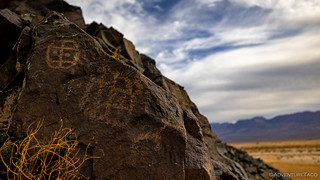
At one point I was wandering around as @mrs.turbodb prepped food, and completely by accident I stumbled on a set of petroglyphs etched into the faces of several well-patinaed rocks on the hillside. Excited by the find, I started hopping around looking for - and discovering - more! For all the planning I do for these trips, I must say that some of the most joyous moments come from the unexpected events that get sprinkled into any trip - nature's way of keeping us on our toes!


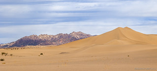
After a quick breakfast and liberal application of sunscreen, we headed east towards our second sand dunes in as many days. Like the Panamint Dunes, the Ibex are (relatively) rarely visited, but unlike our excursion the previous day, we had a much shorter trek - just under two miles - to reach this set of sandy hills.


I'd expected our hike into the Ibex Dunes to play second fiddle to the Panamint, but I was surprised to find that they significantly exceeded my expectations. Not only did the hike itself seem more interesting - which I'll get to in a moment - but for some reason the shape of the dunes was more pleasing to me as well. Strange how reality can exceed expectations sometimes!

For much of our hike, we'd noticed strange white "boxes" dotting the landscape, a few hundred feet from the trail. All of them seemed just a little too far away for us to want to investigate - perhaps that was the intent (!) - until we noticed #8, just a hundred feet or so away. Curious, we went over to check it out.
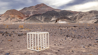
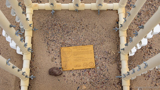

For more information about the science project we stumbled upon, check out UCLA's Project Ibex Wind Study.
Note: I emailed them to update them on what we found... and never heard back.
Besides summitting the dunes - which we'll get to in a moment - another reason for the trek across the sand blown landscape was to check out the remains of a mine that I'd spotted during my research. Hidden behind the dunes at the base of the Saddle Peak Hills, the Rainbow Talc Mine has an interesting history (Dust Up Over Talc) - one of the most recent battles between protection of the National Park lands, and the mineral rights of landowners.


The mine extends for nearly a mile along the base of the Saddle Peak Hills, and following in the footsteps of those before us, we set off to explore.

Tracing the base of the hills, it was fascinating to see the bits and pieces of history that were out here. A plethora of tires in various states of disrepair, more than a dozen mine/claim markers, and an interesting mix of sand and rock, the dunes slowly encroaching onto the fanglomerate on which I can only assume the original road was constructed. And along the way, mining artifacts - inclined shafts, ore chutes, and adits dotted the hillside. Naturally, we stopped to investigate them all.


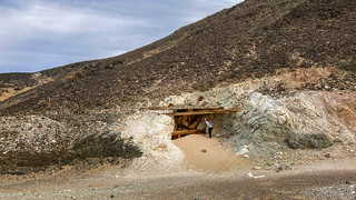



After exploring the mines, it was time for us to make a decision - would we be happy with having circumnavigated the dunes, or did we feel it necessary to climb to the top? For each of us, it turns out, the answer was different - and so, after setting up the tripod and camera for @mrs.turbodb, I set off for the summit, being as careful as I could to make it seem that - rather than walking - I'd been dropped there from a helicopter.

It probably only took me about 15 minutes to get from the vantage point we'd chosen to just below the summit of the tallest dune, circling around the back side and staying just below the ridgeline so as to maintain the pristine look of the dune in any photos.
As I neared the summit, I glanced down to see my photographer making her way to a secluded spot a couple hundred feet away from the camera. Certain that it was a bathroom break, I wondered why she didn't just take care of business out in the open - at more than a half mile away, I could only just make her out and - I thought at the time - was the closest around.
Figuring I had a minute, I turned around to soak in the views - the colorful Ibex Hills providing a fabulous backdrop to the west.

I don't know how long I'd been turned around, but it couldn't have been more than two or three minutes, when I decided it'd probably been long enough. Peering down again, I was surprised to see three hikers - the frontmost of which had just passed the camera setup and was headed towards the bluff behind which @mrs.turbodb was wrapping up her business! She emerged just as he rounded the bend, and - I could tell - was a little flustered, sprinting away from the hiker and back to the waiting camera! Understandable, I think, given the remoteness of this region.
I'd later find out that the interaction had been friendly, with the hikers asking her if she shot here often and what here Instagram was. LOL.


With the Ibex Dunes in the bag, that means I've now tackled most of the dune fields in Death Valley, having previously hiked the Eureka Dunes, Hidden Dunes, Mesquite Dunes, and Panamint Dunes. I don't have many - or really any - bucket lists in my exploration, but I do find the dune fields of this place intriguing!
A smile on my face, I headed straight down the 45° face of the dune, sliding into the sand as I cascaded along.

And with that, we retraced our steps - my camera battery dying along the way - to the Tacoma, where we emptied out our shoes and enjoyed another great lunch in the desert!
Looking back now, the Rainbow Mine of the Ibex Dunes was the absolute perfect transition - from sand dunes to talc mines - for this trip. In fact, the entire rest of our adventure would be spent exploring the plethora of talc mines in the region, with the first being just a few miles away and accessed from the parking area at Saratoga Spring.


We didn't linger all that long - both of us looking forward to reaching camp before dark for the first time this trip - before setting out on our last hike of the day. After our usual sunscreen and hike-prep routine, we headed north - along what used to be an old mining road but is now just a hiking trail - toward the three groupings of the Saratoga Talc Mine. First though, we'd experience the wide-open views of the spring, the sound of birds and frogs, alien elsewhere in the desert.


The area around the spring has been used by various mining endeavors since the 1880s, and was surely used much earlier than that by indigenous people. Today, the ruins of two stone structures are all that remain adjacent to the spring. Originally built in the twenty-mule team days (late 1800s) to serve as a saloon and a store, one was revamped in 1909 and used as a blacksmith shop by the Pacific Nitrate Syndicate.
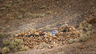
The Saratoga has three groups of mines that work the talc veins of the Ibex Hills. The first mine - about a mile north from the spring, and the only one we'd hiked to on our first visit to this area a few years ago - is the southern group. Opened in 1949, it produced very little product. Its ore chute and small tin shack - visible up the canyon wall, 300 yards east of the trail - are worth the climb, and if you poke around just a bit, you may also discover the old blasting shack carved into the hillside.


Developed in three stages, the northern and middle group of mines are located directly across a wash from each other, though only the northern group is initially visible from the trail. Originally worked in 1944, it was reactivated by the Southern California Minerals Company in 1949 and - like the southern group - produced only small amounts of ore before being abandoned in 1954. It does, however, have a large open cut of talc with several tunnels above a two-chute ore bin, surrounded by a jumble of metal ducts that were used to transport material from the cut. Both the ore bin and talc cut are worth checking out.

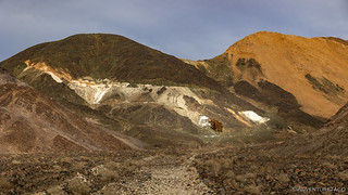


Compared to the other two groups, the middle group of mines fared somewhat better - yielding a few thousand tons between 1955 and the mid-1960s - but, by the late 1960s, these mines failed like many others in this harsh environment and all mining had stopped. Today, all the Saratoga holdings are now idle, and are in the possession of Pfizer, Inc.
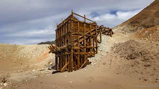
This middle group has - what we thought were - the most interesting structures to admire. A tall wooden headframe stands above an inclined shaft, with a concrete pad high on the hillside where the winch that pulled the carts up the rail was anchored. Ore would have been emptied into the small ore bin beneath the hoist, where a rail-based ore car would transport it to a large ore bin at the tip of the tailings pile. Unlike any other ore bin I've seen in the park, this one - with its X-shaped braces - allowed trucks to drive under, rather than beside it, in order to pick up their loads.


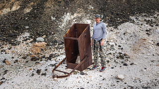

It was a little after 4:00pm as we wrapped the the exploration of the Saratoga Mines. With an hour before sunset we made our way back to the trailhead, having added another 5 miles of enjoyable desert hiking to our day. From there, it was only a short drive - back from whence we'd come, between the Ibex Hill and Ibex Dunes - to find camp and make dinner before the last of the light left the evening sky.


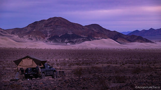
Finally, we'd done it: we'd reached camp before dark! That's not to say that a headlamp wasn't utilized here and there in the cleanup after dinner, or that we lazied around for hours in camp before hitting the sack after a long day of hiking, but it was a nice feeling to enjoy the purply glow from our camp chairs rather than at freeway speeds in the cab of the Tacoma.
We'd hit the sack early - as seems to be our habit during the winter months - with a plan of visiting several more white powder mines the following day. We had no idea at the time, but we'd saved the most exciting treasure hunt - and discovery - until the very end!


Really enjoying your adventures. Many decades when I was young my friends and I explored throughout the Mojave looking into mines and other relics, most in the area of Randsburg, Johannisburg, Red Mountain, Garlock, etc. We even had a mining claim with a shaft east of Red Mountain. Your posts have got me trying to think of a way to go from my 2WD pickup truck to a 4WD that we could use to go back out and do more exploring, visiting some the places we'd been decades ago. Thanks for sharing.
Dan
Pictures of the mines and your descriptions are wonderful!
A great find, for sure...
Thank you for the adventure!!!
David
My great grandparent owned the Rainbow Talc Mine. I have many old photos of the mine when it was active if you'd ever like to see them!
Wow, thanks for posting a comment here to let me know, and thanks so much for the offer! I would love any history or photos you have on the mine, I always find the firsthand experiences/stories that people relate to me add so much to my enjoyment of a place.
You can’t attach pictures to these comments, but feel free to email them by replying to the comment notification email you get.