
I'm not a huge fan of airing up tires, so once we've aired down on a trip, I generally try to stay aired down until the trip is over and we're pounding pavement towards home. Today though, we had 350 miles of pavement - and a ferry to catch - between Lillooet and our next item on the agenda along Upper Arrow Lake, so we took the time to run the ARB compressor and get the new Kenda Klever RTs up to full pressure before speeding along at 100 mph. Err, km/h, which is basically the same, right?


Everything considered, we - and by we, I mean I - were reasonably constrained as we traversed the province. With countless rivers and lakes, we could have stopped any number of times for breathtaking views, but we soldiered on with our destination in mind: Halfway River Hot Springs.

I forget what time it was exactly - it must have been sometime after lunch - but I realized that I'd forgotten to look up the hours of operation for the Upper Arrow Lake ferry. This shouldn't have been a problem - I'd ensured that my Verizon phone was setup for phone+text+data while we were in Canada - but for some reason, the data part of that equation was non-operational. So, as I navigated the disaster that is Verizon technical support, I pressed the skinny pedal a little further towards the floor hoping that we'd make it before 5:00pm, which we figured to be the most likely stoppage point for the day.
Pulling into the short ferry line at 4:45pm, we breathed a sigh of relief to be joining other vehicles headed in the same direction. And, a quick glance at the posted schedule made us chuckle - the ferry ran from 5:00am to midnight every day of the year, our rush had been unnecessary!

There are 14 of these Inland Ferries, all operated under private contract with Canada's Ministry of Transportation and Infrastructure. All of them are free of charge to users, and every time I've ridden on them, they've been a blast!
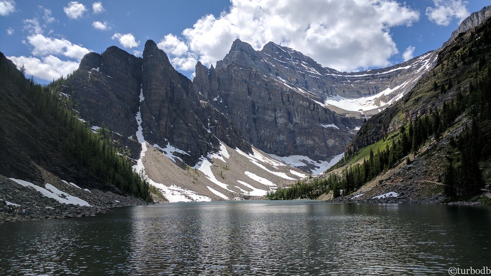
After disembarking, it was a few dozen miles to a place that I suspected would be @mrs.turbodb's favorite of the trip. She's always on the lookout for warm pools of water to soak in, and the smile on her face when I'd mentioned that there was a hot spring on this trip was fantastic.


I'd heard about Halfway River Hot Springs from a fellow adventurer, and this place is clearly off the "secret spots" list these days. 12km up a Forest Service Road (FSR) of the same name, the perfect time of year to visit - we think - would likely be during the dead of winter, when snowshoes and a long hike would be required to reach the pools. There, then, a winter wonderland could be enjoyed in solitude and warmth - a perfect combination!

After a pleasant soak, we headed slowly back up the stairs. At the top, a fresh dinner of caprese salad, fresh cucumbers with salt and vinegar, and hummus-on-pita-chips urged us to pick up the pace, but we resisted, to keep from breaking a sweat only moments after rinsing off in the springs.
A pleasant evening fading to night, we wandered our way to a nearby dispersed camp site nestled into the trees. After a short stroll to gaze into the whitewater of the Halfway River, we set up the tent and were soon sound asleep.
The following morning...
When it comes to trip planning, my achillies heel is trying to squeeze as much as possible into however many daylight hours are available on a particular day. This seems to happen regardless of what time of year it is, meaning that the 16-hour days of summer are just as packed as an 8-hour day in the dead of winter.
And so, when my alarm sounded a few minutes before sunrise, it was with both surprise and relief that I hit the snooze button so we could get another 30 minutes of sleep before getting under way.
30 minutes, boy, what a respite!


After a quick stop for 20L of fuel to top off the tank, we arrived at the trailhead of a trail that I'd gotten wind of from several Canadian adventurers. Two of these guys - Mike @POSTacoMike and Shaun (of The Story Till Now) - have an is-it-sketchy? bar that is significantly higher than mine, so I'd been sure to reach out to Mike to ensure that the switchbacks I'd mapped on the trail were actually doable for a single Tacoma on 33-inch tires.

Mike assured me that they were. More importantly, he let me in on a little secret: the switchbacks that he and Shaun had called "unreal" were on a connected, but different, pass.
I wouldn’t send you there. There’s a bridge that’s nearly gone, and if it goes, it’s big tire country to get thru. And it’s going a little more each year!!
Mike
Full of overconfidence, we aired down and set off into the woods. I'd planned three hours to conquer 17 miles of steep terrain, and while our speeds initially suggested that I might have overestimated, we ended up using our full allotment by the time we were done.


Climbing through tree tunnels and winding our way along old roads, we found ourselves wondering - as we often do - who created these paths through the trees. Were they after gold? Loggers, perhaps? The answer would become obvious once we reached the final push to the summit - this was mine country - but as we continued to gain elevation, there was little clue as to their origin.


I'd been hoping that this track would lead us above the tree line, but with a max elevation of 7,500 feet, avalanche chutes - and a few plots of logged land - were the places where panoramic views presented themselves. With blue skies, high clouds, and temperatures that couldn't have been more pleasant, it was spectacular up here.


A quarter mile from the top, the easier-than-we'd-expected trail literally took a turn that led straight up the mountain. Here, spur trails fanned out across the hillside, some of them leading to old tailings piles, others to the decaying remnants of collapsed mining structures. Working up here had to be a pleasure, with million-dollar views likely the primary reward.
Pointing the Tacoma up, I was glad for the traction afforded by the 19/32-inch lugs on the brand-new Kenda Klever RTs. Surely my old S/T Maxx - a great tire that I'd run down to the wear bars - wouldn't have had the gumption to keep us moving upward in the soggy loose soil.


Having reached the top, by 10:00am, it was way too early for lunch so after soaking in the views and poking around the pass a bit, we piled back into the Tacoma to tackle the descent. And the 28 switchbacks.
Ultimately, I much preferred the controlled descent offered by the switchbacks as compared to the white-knuckle-straight-up-the-mountain nature of the ascent. I did discover that the new wheel and tire combination sat a little further inboard - and had a tendency to rub on the shock reservoirs at full steering lock - but beside that, we easily made our way down the steepest part of the trail.

In fact, the worst part of the trail was much closer to the bottom. There, alders crowded the road, sometimes so narrow that even an ATV would catch branches as it passed through. This was no problem - the Tacoma has sported a pin-stripe paint job for years now - but the density of trees reminded us that we'd not brought along a chainsaw.
Because who would need a chainsaw this late in the summer?

Turns out there were four trees down over the road, but the pull saw made quick work of two of them, and we were able to squeeze under the other two, kissing the top of the roof-top-tent both times!

It was just after noon - nearly three hours to the minute since we'd started - that we reached an old mining ghost town and the end of the trail. It was the perfect spot for lunch, and I poked around the ruins while @mrs.turbodb whipped up some tasty turkey sandwiches for us to enjoy in the shade.


The Nobel Five was first mined in the early 1890s. Above the mill/power plant, on the flanks of Reco Mountain, there were eleven levels with the highest being three quarters of the way up. Some of the underground workings extended into Mount Payne the next peak over. From these diggings came tens of millions of dollars' worth (today’s value) of Silver, Lead, Zinc with a smattering of other metals.
The mine operation had several owners over the many decades and sometimes was worked by lessees. It was one of the better producers in the immediate Cody area with Galena (ore of Lead with Silver as a byproduct) and Sphalerite (ore of Zinc) transported to the mill via an aerial tramway, ultimately producing 15,488,641 grams of silver, 2,173,174 kilograms of lead, 1,588,288 kilograms of zinc, 1,961 kilograms of cadmium, and 279 grams of gold.
The busiest period for the Noble Five was 1929-1930 with occasional spurts of elevated activity earlier in the 1920s, again later in the 1930s, during World War II (when demand for metal was high) and lastly in the 1950s. Otherwise, the mine produced but a trickle, or for extended periods nothing at all. What we see here of the mill dates back to the late 1920s/mid-1940s period. There was no mill here before. A fire in the 1940s destroyed some of the structure, which was presumably rebuilt. The mine itself was last worked in the early 1980s.
Powering everything, and outside now, is a generator that supplied the needed electricity. Here it’s a four-cylinder Fairbanks Morse Model 32 diesel engine, which towers over an average-size person and weights perhaps thirty tons. This model was produced between the mid-1920s and early 1950s and could be expected to run nonstop for months or even years on end. The Model 32 was well regarded as being simple, rugged, and very reliable, producing around 250 horsepower. That doesn’t seem like much given its hulking size, but in this capacity, it was more about the torque which this one, no doubt, had in spades. Look at the size of that flywheel.


Lunch - as it was every day on this trip - was a splendid affair. In fact, more than one day we would pass through a town - with plenty of places to eat - but opt for sandwiches that we knew would hit the spot. Plus, we'd brought along a few nectarines, the perfect sweet-little-something to slice up before getting back on the road.
And so, an hour after we'd reached the bottom, we were wrapping up the last few miles of gravel road before getting back on the highway and on to our next destination. It was a spot I'd been wanting to show my companion since I'd first visited in 2021. A trail that I'd rushed to see after it was decommissioned and marked for closure by the BC Forest Service. A trail that offered some of the most stunning scenery of any I've ever run.
We were headed to Rady.
The Whole Story


Obviously, Canada is animal all it's own. All that water makes for a completely different landscape (waterscape) than the U.S. Great photos. as usual. Wanted to let you know (since I'm your botanical nerd Uncle) that the plant that the butterflies were on is Pearly Everlasting (Anaphalis margaritaceae). UJ
Awesome, thanks! Updated in the story, as usual. 😁