
It was a little strange to be heading back to the Olympic Peninsula only a few days after having bailed on a trip to the same location, but such is life sometimes. This time - not wanting to retrace our steps through the same terrain to kick off the trip - we decided to pick up the loop around the peninsula at the five-o'clock position, near Skokomish. From there, we'd run the loop clockwise, the opposite direction of our previous attempt.
This meant that rather than take a ferry to kick off the trip, we drove down and around the Puget Sound, eventually transitioning to dirt a little before noon, on our way to the first of two bridges that I'd been itching to see since Mike @mk5 had posted a few photos of them on his trip to the area. Sufficed to say, his photos were more than a smidge better than mine, but we'll get to that in a moment.
The first of these bridges - the Vance Creek Bridge - was a short hike from the road, so we grabbed the camera and headed out the old rail grade until we reached the trestle. Built for the Simpson Logging Company in 1929, it stands 347 feet high and is the second-highest railroad arch in the United States. Decommissioned in the 1970s during the decline of logging on the Olympic Peninsula, the approaches on both sides have been removed in order to discourage foot traffic (which is illegal) on the structure itself.


Needless to say, viewing the bridge from our position was a bit underwhelming. A disappointment, really. The ability to walk out on the bridge would have been cool, but even that wouldn't have given the perspective that would make the country's second tallest railroad arch really shine. For that, one needs an entirely different approach - one not limited by human abilities.
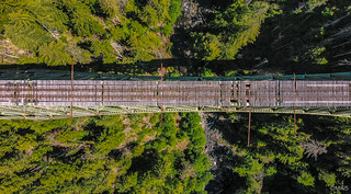
Spending only a few minutes at the second highest steel arch railroad bridge in the United States, it only made sense to experience the highest. As a matter of course, the route we were on crossed the High Steel Bridge, and a few minutes later we found ourselves once again wishing that we had wings to really capture the experience.


Chatting about the drone that I'd love to have in my toolkit, but would dread to use - it would be time consuming, noisy, and inconvenient to carry - we headed back to the Tacoma to put some real miles behind us. These miles - as with many on this trip - would primarily be through tree tunnels, with only the occasional clearing and associated views.


As we progressed along this section of the route - along the southern flank of the Olympic Peninsula - we realized that our plan to finish the entire loop in 3-4 days might have been a bit ambitious. While the roads surfaces were largely in good shape, the terrain dictated innumerable twists and turns as we wound along the undulating folds of the mountainous terrain. This one section was more than 250 miles in length, and we'd covered only 82 miles by 3:30pm.


Eventually - about halfway through the southern route and a little after 5:00pm - we neared an area known as Wynoochee. This is an area we've been before - but only in a "family camping" capacity - but we'd never done any exploration beyond the campground and nearby reservoir. Today, we'd change all that, visiting the first few - of many - waterfalls that I hoped to enjoy along the loop. Afterall, we were exploring a rain forest!


After driving upstream along the Wynoochee River for six miles or so, we reached the jumping off point of our next hike. A short one - at only about a half-mile each way - it would take us to one of the more well-known falls in the area - predictably named: Wynoochee Falls.
Apparently there used to be a campground here as well - many years ago from the looks of the terrain now - which was likely removed in order to limit traffic to the falls, even if only slightly.

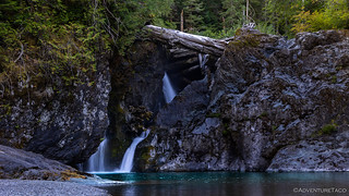

We dorked around at the falls for 20 minutes or so, hopping around on the shore, admiring the surroundings, and wondering - if only a little - what it would be like to swim in the teal blue waters nearest the falls. Ultimately, we'd err on the side of dryness - given the time of day and lack of swimsuits - as we headed back up the trail to the Tacoma, and onward towards a location we could call home for the night.

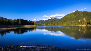
Making our way south again to Lake Wynoochee, we discussed spending the night in the campground only briefly before casting that option aside. In fact, we've camped there twice before - enjoying it the first time but, having one of our worst camping experiences ever (we now despise RV generators), on our return trip. Still, we couldn't help but stop at the southern end of the lake to admire the spillway and take a quick look at the calm waters it retained.

Our quick stop at the lake complete, we had some significant mileage to cover if we wanted to come anywhere near completing this section of the route. And, at least nearing completion was something we definitely wanted to do, since we'd planned on a special hike near Lake Quinault the following morning. Luckily for us - given our prioritization of speed over beauty at this point - we once again found ourselves shrouded in tree tunnels, rendering my desire to stop for photos, significantly reduced.


In addition to walls of tree, the roads soon transitioned to the paved variety. In just over an hour we covered another 50 miles - by far the speediest we'd traveled all day - delivering us to within 15 minutes of our trailhead the following morning.
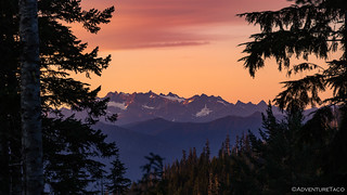
With the sun only moments from dipping below the horizon, we made quick work of finding camp along Quinault Ridge. Nestled into the trees, it didn't afford sweeping views, but with our plan to leaving early the next morning, those would be of little consequence during the night. Still, before making a simple dinner of Ramen, we did find our way to an old logging platform that had a peek-a-boo view of the Olympics at what couldn't have been a more perfect time.
After a few minutes of admiration, our stomachs reminded us that it'd been eight hours since lunch, and @mrs.turbodb got to work boiling water as I set about setting up the tent and making a temporary repair to the front skid plate, where I'd lost a bolt after the threads stripped over the last several trips.
Not long after, we were snuggled under the covers, thankful for the Exped mattress as we comfortably nodded off to sleep in the refreshingly cool night air.
My only concern was whether we'd bitten off more than we could chew. We still had a lot of ground to cover, and unbeknownst to us at the time, our hike the next morning would end up being significantly longer than we'd planned!


I can sympathize with your comment about RV generators. Many years ago we were camping and fishing in the High Sierras. We had the campground to ourselves for a couple of nights and then a huge motorhome pulled in one evening and for an hour or so it was quiet, we went to bed (tent) then we heard the generator and a few minutes later, "Here's Johnny," yet they were watching the Tonight Show. The next morning their two kids were on dirt bikes (banned in the area), next thing we knew the District Ranger came driving in his pickup truck with the dirt bikes in the back and a loud argument ensued. We talked with the ranged and he said the kids were chasing deer on the dirt bikes and the argument ended up with the whole family being banned from ALL Parks and National Forests FOREVER! The bikes were impounded and the family cited with a big fine and told to vacate the area immediately! We thanked the ranger.
WOW! That's a great (and sad at the same time) story! Glad to hear the ranger was there; I wish they could fund more of them these days with all the UTVs that seem to think "stay the trail" and "make a trail" are the same thing.
Excellent write-up. I'll definitely be reading it again in the future for when I head that way.
Your response above about the UTVs is spot on. I have zero love for those things. They're destroying trails nationwide and getting huge swaths of land locked up.