
I have to say, it was so pleasant sleeping next to the Hoh River, as it quietly rippled by through the night, bringing cooler temperatures along for the ride. Those temperatures - along with the fact that we were parked in a valley - meant that sunrise wasn't on the agenda, and it was nearly 8:00am when we finally climbed down the ladder to get our day underway.
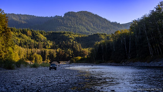
Note: I'm kicking myself a little bit that we didn't camp *in* the river, which was so flat and calm.


Hoping the sun would climb quickly enough to help dry off the tent, we dallied around camp for a few minutes before realizing that we didn't stand a chance of the warming rays for at least another hour or so. With that, I broke out the trusty towel and set to work - removing the majority of the water, but still knowing that we'd need to finish the drying process the next time the tent was opened.
And with that, we were off. Racing out of the Hoh Rain Forest, we headed west to US-101 where we turned north. And, while the mapped route then dove back inland, we decided that no trip to the Olympic Peninsula would be complete without venturing to the most northwest corner (of the lower 48) and walking out to Cape Flattery. Seriously, how could you miss that experience?

For anyone planning to hike Cape Flattery or the nearby Shi Shi Beach, make sure to pick up a permit from the Makah Tribe, which you need in order to park at the trailheads. Permits are available for $20 and last for the remainder of the calendar year in which they are purchased, making them a great deal if you're spending a few days or plan to return for more hiking!
After a quick stop at the Makah Mini Mart to grab our permit, we wound our way out to Cape Flattery and scored a primo spot in the very-full and actively-monitored-and-ticketed parking lot, right near the trailhead as another set of hikers had just returned from their trek.
The entirety of the trail heads downhill - or uphill on the return - transitioning on-and-off of boardwalks that would have kept our feet from getting too muddy, even on the wettest of days. As with earlier rain forest hikes, filtered light made for a pleasant stroll - the crashing surf in the distance, beckoning us onward.

Nearing the end of the trail, there were several short spurs that delivered us to viewing platforms overlooking some of the most dramatic shoreline imaginable. Teal water crashed onto gray stone. Caves - carved over millennia - echoed as waves continued their relentless pounding. Cormorants dried their wings after diving for fish.


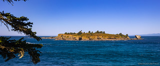
The final viewing platform gives a 270° view off the end of the earth. And it's there - some three-quarters of a mile off the coast - that the Cape Flattery Lighthouse sits on Tatoosh Island.
Designed by Ammi B. Young and built in 1854, its first light was displayed in 1857 - the third lighthouse in Washington Territory. The light was eventually decommissioned in 2008 after a solar-powered beacon fitted with solar and battery backup was built on the island.
The lighthouse and adjacent fog signal building now stand neglected after years of vacancy. Their structural condition is precarious, and they need almost $2 million in repairs to make them safe for use, including stabilization and new roofs.

We hung out at the point for a good thirty minutes or so - me snapping various photos and watching the surf, @mrs.turbodb catching wind of a spouting whale and watching it blow several times far out at sea - before heading up the trail and back to the Tacoma. We stopped only briefly along the way, a tree more famous than us, getting one more photo taken of its unique form.

Reaching the Tacoma around 11:30am, both of us were hungry and talk turned to lunch. We'd noticed a gravel road - Cape Loop Rd - leading away from the parking area, and noted on our map that it appeared to offer some promising spurs that overlooked the coastline as it worked its way back to Neah Bay. Worth a shot, we decided!

It turns out that none of the spurs we'd hoped to enjoy were passable, and exactly halfway back to Neah Bay, the road had been decommissioned - two large berms and a deep ditch, carved across the path. Bummed - but not surprised - we turned around and headed back, eventually finding a small opening in the trees for a final shot of Tatoosh Island, as long as we stood on the RTT in the back of the truck!

Ultimately, having set our sights on eating with a view of the ocean, we headed south - along the western shoreline of the peninsula - until we found a nice picnic spot along Hobuck Beach. There, a nice table in the shade was the perfect spot to consume some quickly assembled sandwiches, fruit, and chips to satisfy our grumbling tummies. It was 1:15pm!


Now, the fact that there appeared to be a road down onto the beach - right next to the table we'd eaten at - hadn't gone unnoticed by either of us. We had no idea if it was legal to drive on the beach - though others obviously had as there were plenty of tracks into the soft sand - and neither of us really had any desire to get the truck salty and sandy, but we figured a quick shot that implied the Tacoma went for a swim could be fun.

We, however, definitely wanted to walk out onto the beach - the blue sky unencumbered by fog as it had been the day before - and soon we found ourselves strolling the shoreline as the waves washed in and out.

As nice as it was, we couldn't hang out at the beach all day - we had a lot more of the Olympic Traverse to cover before we reached our starting point - and headed back to rejoin the route as it worked its way toward the Sol Duc area of the Olympic National Park.
Most well-known - I think - for the Sol Duc Resort (and hot springs) as well as a short hike to the Sol Duc Falls, like the rest of the Olympic National Park, I think the real gems are hidden deeper in the park, protected from the hoards by the tens-of-miles of hiking necessary to achieve them. While we didn't have time for a multi-day backpacking trip of that sort, we did have a couple of spots that were sure to delight.
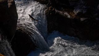
The first was a natural salmon ladder. A constriction in the Sol Duc River, this is a place where - every year - migrating salmon bunch up as they try to jump their way through raging rapids in order to reach their spawning grounds. As you can imagine, this can take a bit of effort, and more often than not we'd see an enormous fish swept back into the pool from which it launched, rather than succeeding in its attempted swim upstream. Still, it was a sight to behold!


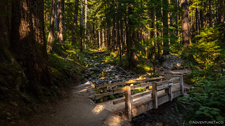
From the salmon ladder it was just a few more miles to the end of the road and the trailhead for our next excursion - a mile or so hike to the Sol Duc Falls. Designated as a footpath, but populated like a highway, we found ourselves wishing that we were just a couple hours later in the day - as we had been in the Hoh Rain Forest - so the trail wasn't quite so busy. Still, there was no arguing its beauty as it worked its way upstream and through the moss-draped forests that had become so familiar.


We arrived at the Sol Duc Falls just after 4:00pm. Depending on water volume, the fall can support as many as four channels, cascading some 48 feet into a narrow, rocky canyon before passing under a bridge high above. Needless to say, the drama was high as folks searched for the perfect shot of these fabulous falls.


As always seems to be the case, the hike back was quicker than the hike out. Thinking we might be able to pull off a similar feat as the evening before, we scoped out a few spur roads along the Sol Duc River and hoped that we'd find a gravel bar where we could prep dinner and enjoy the cool air flowing down the valley.
It was wishful thinking.
Unfortunately, each of the spurs had been gated, and eventually the road we were on migrated away from the river altogether as we re-joined the loop we'd been following for the last several days. Now, it would take us along the shores of Lake Crescent - the air suddenly thick with wildfire smoke - as we began the easterly leg of our journey.


Having failed to find a camp site on our first attempt - though surely, we would have found something as we continued driving - the thick smoke prompted a conversation about where we wanted to spend the night. In the end, we decided that - even though it would mean a late arrival - that we could probably make it all the way home if we really pushed it after dinner. That would alleviate any need to rush through dinner or eat in the dark, and would come with the benefit of a shower once we reached our destination.
And so, we decided to make our way to Camp Hayden - an old installation that was built to be part of the coastal defense system during World War II - where we'd eat dinner and enjoy the sunset.


Two 16-inch guns were installed here to defend against enemy naval aggression. Each gun was over 45 feet long and could fire a 16-inch, one-ton (2000lbs) projectile, 28 miles. The red projectiles, inside the tunnels, are similar to those used during World War Il. Designated as Battery 131, the two monster guns were mounted on Barbette Carriages housed in concrete structures. The turntable, on which the guns and loading mechanism revolved, was large enough to turn a small locomotive. The No. 2 gun (westernmost) at Camp Hayden was fired several times for practice. The No. 1 gun was never discharged.
The missile age made the mammoth precision-tooled instruments obsolete as soon as construction was complete in 1945. The Owens Brothers, who got the contract to scrap the guns, used electric torches and dynamite to reduce each 16-inch behemoth to 500 tons of scrap, worth $30 per ton ($15,000 in all). The guns had cost the taxpayers several million dollars.
-Info Sign


We found a nice place to set up for dinner, and after deploying the tent to dry, I wandered around a bit to check out the rest of the installation, as @mrs.turbodb got going on gnocchi and green beans that we'd enjoy as the sun set to the west.


Dinner was quick and before long we were headed south - the sun now below the horizon - toward the ferry that would carry us back across the Puget Sound, the way we'd come nearly a week before.
In the end, both our fears and curiosity of this area were realized. Put bluntly, many of the driving aspects of this trip were monotonous. While the truck was in motion, there was only one type of terrain - forest - and by and large, only one view - tree tunnel. Still, there were treasures along the way: hikes through majestic rain forests, along sharp ridges, and to the crashing waves of the Pacific Ocean. Historic bridges towering above plunging ravines. Here and there, Olympic-sized views that only hint at the wonders that can be found on the Olympic Peninsula if one is willing to tackle the passages to get there. Those are the wonders that made this trip one we'll remember.


Really appreciate the narrative and great photos (as usual), almost like visiting these places ourselves which is a boon to those of us who won't be able to visit these places in person. Yes, age and health limit our travels which makes me appreciate the journeys that you and others share. Thanks again! Lighthouses are wonderful and the few we've visited that local groups have maintained and restored are always a joy to behold!
Thanks as always John. Such a pleasure to "have you along" in the comments. It's such a fun experience - for me - to pop in and see that you've enjoyed a story.
And I'm right there with you on lighthouses. I think I've visited/climbed 4-5 of them (not too many) and like old mines, mills, and cabins, they are always so fun to explore and wonder about!
Thanks Dan!
Unusual and fascinating trip, such a nice change from the desert and wide open views. All the greenery is mesmerizing and soothing. I like your use of the ND filters on the waterfalls, great shots.
Thanks again for sharing.
Thanks Kenny! Those waterfalls were photographed "filterless," though I wish I had an ND filter sometimes. A polarizer as well, for shots where I've got lake/river reflections.
I simulate the ND filter by upping the F-stop to as high as I can go - F22 or higher - which of course prolongs the exposure. I find that if I can get even 1/5 or 1/4, I can get enough movement of the water to smooth it out. Still, not as nice as a real ND though!
It's getting cold. We're doing a final trip to SE Oregon here soon, then we'll be "headed further south" until it starts to thaw again!
Excellent capture without the ND filter. A small investment for a set of ND filters and a polarizer filter will take your photography to the next level. I use my polarizer filter often to remove the reflection on the water.
Where in SE Oregon will you be going? Perhaps we can meet up for a visit. Watch the weather reports (as crazy as they are) as rain is predicted and you know the Owyhee gumbo mud.
Blessings,
Kenny
Amazing trip. Pictures and article just wants us to go and travel there.
Living in Kingston, we’ve spent a lot of time on the Peninsula but not out to the point, because, as you mention, the drive through the endless tunnel of trees is not inviting. But after seeing your pictures, I guess we’ll have to make the drive….
It's definitely worth it at least once! Glad the photos could inspire you to go! ?