We had many miles - all on pavement - to cover after descending Redline FSR in British Columbia's Purcell Mountains. You see, it seems that in eastern BC, the highways run almost exclusively north-to-south, with only occasional drifts to the east or west. Since parallel roads never cross, it's only the rare instances where one highway drifts east as another drifts west that one can work their way horizontally across the province.
Of course, it's not all bad. It's the spectacular mountains - often topped with glaciers - that prevent the easier east-west movement.

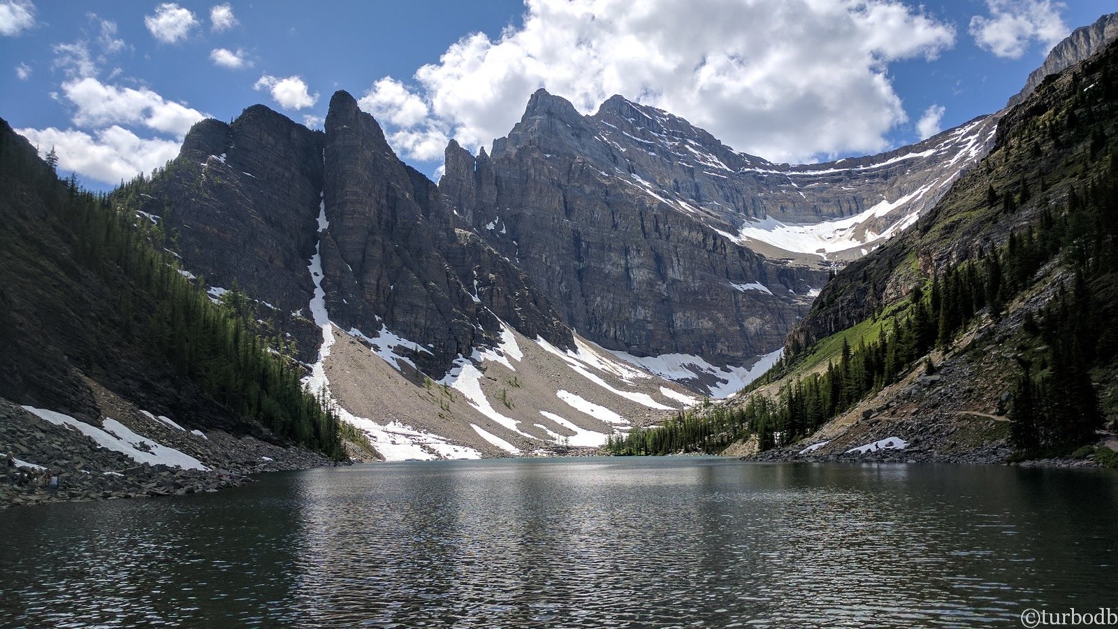
Always a treat to wind our way through Rogers Pass and Canada's Glacier National Park.
At any rate, after airing up for higher speed travel, we followed BC-95 north to Golden and then hopped on the Trans-Canada Highway to Revelstoke. We were making good time until this point, and after a short stint on BC-23, we found ourselves waiting in line for the Shelter Bay ferry.
There are 14 of these always-free ferries that operate under private contract with the Ministry of Transportation and Infrastructure, and we've taken this ferry across Upper Arrow Lake a number of times. Usually waiting in line for any of BC's Inland Ferries is a quick affair, but today, signs along the road alerted us to the fact that there was a two-ferry backup, which - by the time we arrived - had stretched to three ferries and more than two hours!


While we were waiting, I sent our little reconnaissance buddy up get an update on the location of our boat. It was, as we suspected, in the lake.
We'd planned to eat lunch on the ferry, but that plan was soon out the window as our pasta salad took significantly less than two hours to eat. Then, @mrs.turbodb settled down to a bit of knitting, while I began to copy photos off of the camera and drone in order to pass the time.
We should have followed the lead of the locals and gone to jump in the lake, but alas, we soaked in our own sweat, instead. Eventually though, there was room on the sailing bridge for the Tacoma, and we were off to Galena Bay.

The ferries are just a part of the highway, and even the deck of the ferry looks like a continuation of the road.
It was nearly 5:00pm by the time we'd completed our float, and with our final trail - up and over Hailstorm Pass - leading us decidedly west, we figured that it would be much more pleasant to make the climb in the morning - with the sun to our backs - than it would be to rush into the mountains while fighting the sun the entire time.
And so, with a bit of time to kill, we made a very important stop in New Denver.

I was so excited to eat this tasty treat that I completely forgot to take a picture until it was nearly gone. This, then, was my attempt to even out the rim of the cone and prop up what little mint chocolate chip goodness was left, before playing with perspective to make my 2" tall ice cream look at least 2.5" tall.
As we licked our worries away, storm clouds rushed in from the west. Within minutes, we could no longer see the mountains where we'd planned to spend the afternoon - and night - as they were completey obscured by a torrential downpour. Oh, and the lightning. So, that's not to say that we enjoyed our wait for the ferry, but there certainly was a silver lining our delay!
After finding a spot to call home for the night, we ate a quick dinner and fell asleep to the pitter-patter of rain on the fly.
The following morning...
The rain stopped by midnight and the tent was fully dry by the time we were on the road - just after sunrise - and on our way to Hailstorm Pass. Having camped in a bit of a fishbowl, we'd skipped breakfast, opting instead to wait until we hit dirt and could air down the tires at the same time.

A few clouds still hung over Upper Arrow Lake as we headed to the trail.

Soon we were climbing away from the lake.
While it turned out that our hesitation at heading up the pass the previous evening - so the sun wouldn't be in our eyes - had been a non-issue given the storm warning that clearly alleviated any errant rays, our hope that we'd have the sun at our back in the morning didn't work out all that well, either. The rain, wind, and lightning were gone, but in their place were low clouds and soggy ground. Not quite the grand finale we were hoping for as we made our way towards home, but good timing in that we'd completed our two hikes - to the Conrad Kain Hut and The Lake of the Hanging Glacier - and enjoyed two nights up in the glaciers, in mostly fabulous weather.

The views, they might be amazing.

False summit of Vingolf W2.
That's not to say that we didn't enjoy the lower-level surroundings that were still visible. Every now and then, the forest would open up - funny how the Canadians clear large swaths of trees in order to improve the views, or something - and we'd get a sense of the grandness around us.

What a considerate country, to make viewpoints like this!

Taking a step back, the real reason for these expansive views was much more utilitarian. Lumber.
Tooling along, the relative lack of views meant that we made reasonably good time as we traversed Shannon Creek FSR on our way to the switchbacks that led to the top of the pass. As usual, these roads - now used for logging - were originally plotted and cleared for an entirely different reason: mining - and relics of the past still decorate the landscape along the way.

This old mining workshop was still full of tooling and ore to be processed.

A mile further up the road, an ore chute - perhaps the source of some of the ore in the workshop below?

Just before starting up the switchbacks, we crossed through a mosquito-infested meadow. It sure looked nice from the air, though!
I'd been hoping that the clouds would clear by the time we got to Hailstorm Pass, but as we started up the hillside, it seemed that they were pushing lower, even obscuring the nearby tops of Grey Wolf Mountain and Hailstorm Peak. But hey, at least it wasn't raining. Yet.

Up we go, Grey Wolf Mountain lost in the clouds.

View from the pass.

Our road.

Break in the clouds.
With only the western descent between us and pavement home, we figured it was only a matter of minutes - perhaps 30 or so - before we'd be looking for a spot to air up for the final time.
Turns out, not so much! Looking at the GPS route when I was planning the trip, I'd assumed that the climb up the east side of Hailstorm Pass would be the more difficult of the roads. However, coming down the west side, we soon found ourselves on a much more technical route than the steep-but-otherwise-uneventful climb up the east.

Speed bumps.

With a little careful tire placement and some flexy suspension, we made it through with little fanfare.
Knowing that we had several - as in something like 10 - hours to drive once we were out of the mountains and before we pulled into the garage at home, I'd planned on skipping a spur road that split off from Hailstorm Pass and wound its way up Tillicum Mountain. But, having made great time - it was still only 10:00am as we encountered the fork in the road - my copilot suggested that perhaps we should give the spur a go.
I cranked the wheel and liberally pushed on the skinny pedal before the suggestion could be reconsidered. She didn't have to ask me twice!
As we once again began to climb, the clouds - dry to this point - opened up with a force. Huge raindrops pelted the Tacoma, and I didn't mention it to @mrs.turbodb, but I found myself hoping that the terrain we'd encounter could sustain such a deluge without turning to slop, a condition that's never much fun when traversing narrow shelf roads in the middle of nowhere.

Rockslide!
It turns out this spur led to the old Tillicum Mine along the top of the ridge.
The Tillicum Gold Property comprises 237 claims lying over Tillicum Mountain, located 8 miles by road east of Burton, which is 20 miles south of Nakusp, in the Arrow Lakes region of British Columbia.
The old mining camp is now falling into ruins.
Core samples from various explorations are housed in small structures in the upper left.High-grade surface occurrences of gold were discovered on Tillicum Mountain in 1980 by local prospectors, Arnold and Elaine Gustafson. In September 1980, the Tillicum Gold Property was optioned to Esperanza Explorations Ltd. and Welcome North Mines Ltd. These companies carried out surface exploration and also sent a 64-ton bulk sample of the original discovery, the Money Pit, to the Cominco smelter at Trail, B.C., where the material averaged 2.3 ozs./ton gold.
In early 1982, Esperanza acquired Welcome North's 50% interest in the property and in June a financing agreement for exploration of the Tillicum Gold Property was reached with La Teko Resources Ltd.
This 1982 exploration resulted in several new discoveries and greatly expanded Tillicum's potential for gold reserves. The richest of these discoveries - the Heino Pit - yielded coarse visible gold and assayed up to 147 ozs./ton, and four more zones - the 950, 1250, East Ridge and Grizzly Valley - produced promising results as well, attracting interest from more than 30 other mining companies to the surrounding area.

With rain falling, our exploration of the Tillicum was limited and before long we were back in the Tacoma and once again headed down the hill. Our speed picked up consistently as the road conditions improved and before we knew it, we were waiting in line at the Fauquier - Needles ferry crossing. Luckily, we were third in line this time - we'd only wait minutes rather than hours - and as we proceeded to air up, we watched the ferry haul its load across Upper Arrow Lake on a series of three cables!
Soon, it was our turn.

Not a wide crossing.

Second row seats. As we loaded, I asked if we could move into the front, middle position so I could take photos with the Tacoma more easily visible, but the ferry operator literally laughed at my request and moved on.

Crossing the same lake we'd crossed the previous afternoon, only at a different spot and in the opposite direction!

With only winches pulling us across, it was a smooth, quiet ride.

Four minutes later and we're almost there!
Back on solid ground, we ate a quick lunch at a nice picnic table at the Needles ferry launch and then settled in for our drive home. It'd been another fantastic trip across the northern border, a place we couldn't wait to visit again in the future!
The Whole Story