
One of the very first trips we took was to run the original Oregon Backcountry Discovery Route (BDR) in July 2017. In fact, we attempted a segment of the route in May on our way home from a trip to Oregon's Malheur National Wildlife Refuge, but lingering snow and dozens of down trees made progress painfully slow. We enjoyed it so much that every year since, we've picked another BDR to tick off the list.
This year, Colorado is the name of the game, and it's one I've been looking forward to for quite some time.
The route begins at Four Corners - where CO, AZ, NM and UT meet - in Navajo Nation. It then winds its way 745 miles north - much of the route above 10,000 feet as it climbs and falls through the San Juans and Rocky Mountains - to the Wyoming border. Along the way, high mountain passes, expansive views, numerous mines, and extended water crossings add a bit of excitement.
Two-Day Drive
Getting to the beginning of the COBDR was not a quick affair. The 1,217-mile drive wasn't the longest we've done to kick off a BDR, but it was long enough that we spent two full days working our way south. The first - through Washington, Oregon, and Idaho - was uneventful, and at midnight, we found a spot to camp on a small slice of BLM just north of the Utah border, and the sprawling metropolis that is Salt Lake City. Day two, we cruised down through SLC, Moab, and Monticello, soaking in the red rocks that Utah took home in the landscape lottery.

At one point, in the middle of nowhere, I got out of the Tacoma to take a photo and this little guy raced over from his hole, looking like he wanted to fight!

I've never stopped at Wilson Arch before, because I'm not sure I've ever driven by in daylight.

This view of Wilson Arch almost looks surreal to me.
Let's Get Going
It was just before 6:00pm when we arrived at Four Corners and the beginning of the COBDR. We'd arrived via Cortez, CO, poor planning on our part - we should have approached from a different route - given that we would retrace our 30-minute drive through Cortez as part of the first stage. Still, we paid our $8/each to enter the Monument and soon we were braving the heat to check out a little marker on the ground that denoted this unique place.


There wasn't much wind, but a gust caught the stars and stripes just perfectly as we approached. (left) | Four states here meet in freedom under god. (right)
We spent a total of about 15 minutes at Four Corners; I was surprised at how underwhelming it seemed, though looking back now, perhaps understated is a better description. Then, to escape the heat - it was still in the low 90s °F - we piled back into the Tacoma and began talk of what we'd have for dinner after pounding pavement for the first 40 miles of the stage, as we returned to Cortez.

Officially under way!
Halfway to dinner, we passed - for the second time - a couple of rock formations that'd caught our eye on the drive down. We'd refrained from stopping then - knowing that we'd be back, and not sure what the sunlight situation would be - but with plenty of light and spectacular views, we made a quick detour to check them out.

Chimney Rock.

Papoose Butte.
It was the first of many times that we'd release our little buddy into the sky to snap a photo or two, and before long it was racing back toward the Tacoma as we continued to search for a place to fill our bellies before we hit dirt for the first time.
Ultimately, when we decided on El Campestre. @mrs.turbodb popped in to order our dinners while I did something or other to the Tacoma outside. A few minutes later, she emerged with three carne asada tacos each, beans, rice, chips and salsa. The chips and salsa were fantastic, and all but the beans were reasonably tasty, though probably not worth a return visit in the future. We ate quickly as the sun was setting, and we still had a good number of miles before we'd leave pavement and have the opportunity to find camp.

We turned onto dirt at 8:21pm, the light now fading quickly. We'd be finding camp in the dark.
There were plenty of spots to camp where the asphalt transitioned to dirt, but they were all extremely dusty and most of them were very close to the road. After a bit of searching, we found a spot that was too dusty and too close to the road, but less dusty and further away than the rest, and I quickly set up the tent while @mrs.turbodb got ready for bed. We were both exhausted from two full days of driving, so after flipping only a couple pages on our Kindles, we were out cold.
Or hot actually. It was still quite warm, and I for one fell asleep on top of our comforters.
The Following Morning...
It was early the next morning - around 12:15am - when I awoke for the first time, to the smell of smoke. Thick smoke. It was as though someone had started a campfire immediately next to the Tacoma and then wafted all of the smoke into our tent.
Except that there was no nearby campfire, and - as I climbed down out of the tent to evaluate the situation and go pee - I could see that the entire area was bathed in a blueish haze. After looking to the ridgelines around us for an indication of fire or light, I was reasonably certain that we were in no imminent danger, and I climbed back into bed for the remainder of the stinky night. Our tent and bedding would smell like campfire for the remainder of the trip.
It was awful.
We were up again at 7:30am - an hour after our usual sunrise awakening - and opted to skip breakfast so we could escape the smoke. We didn't know how long that would take, but we crossed our fingers that we weren't in for a full day - much less a full week - of views obscured by burning trees.

Our site was nothing special, even from the air.

It was extremely smoky as we wound our way through the trees along Bean Canyon Road.

Even as we popped out of the trees nearly an hour later, it was still smoky and gross.
We pushed on, with the roads - thankfully - cooperating, their relatively smooth surfaces allowing us to travel at a good clip in order to escape the smoke as we continued in a northeasterly direction toward the San Juan Mountains. Entering the foothills, we began to gain elevation, watching behind us as the heavier smoke nestled down into the valleys through which we'd come.

There was still smoke as we cruised along next to Belmear Mountain, but it was finally thinning!

Passing through 10,000 feet for the first time, it was still spring on the hillsides, and it was beautiful!
As we completed a tight switchback at 10,811 feet, Groundhog Mountain came into view. We hadn't seen any other vehicles for the last few hours, and with the smoke now mostly gone or below us, I announced that we would be stopping in the middle of the road to enjoy breakfast with a view.

Wonderfully smoke-free view of Groundhog Mountain.
Twenty minutes later - and having forgotten to eat any of the fabulously sweet blueberries we'd picked from our garden prior to our departure - we were back in the truck and headed toward Telluride. At this point - and for the next hour - the trail would roll lazily through the hills, stands of aspen and fir reminding us that if we'd come just a month later, we'd have had a much more colorful show. Still, the patchy landscape was beautiful, and we enjoyed it as we played "slow rally car" on the nicely graded roads.

Open spaces.

Primitive bliss.
It was noon as we hit pavement on CO-145 that would take us into Telluride. This is a gorgeous drive along the San Miguel River Valley, and views of the craggily San Juans that make up the perimeter of the Alpine Loop rose up in the distance. We didn't need fuel - for our stomachs or the Tacoma - at this point, but I still wanted to take @mrs.turbodb into town so I could show her a few of the well-known gems that make this place so popular amongst off-roaders.

Our first real peek at the peaks we'd soon find ourselves climbing towards on Stage 2.

The official end of Stage 1.
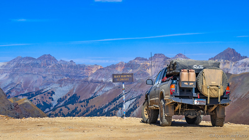
Working our way through town, traffic inched along at a snail's pace. It was the Telluride mushroom festival, though we saw very few actual mushrooms in the vendor stalls that we passed. And of course, there was a constant flow of 4WD vehicles headed out of town in the opposite direction, many of them having descended the one-way, infamous, Black Bear Pass; the rest having approached from the Telluride side - like us - as posers.

When you're done with the hard part, these switchbacks deliver hungry drivers to the town below.

At the edge of the switchbacks, high above town, a waterfall cascades over the rocky cliff. Someone thought it'd be a great idea to build a powerhouse right on the edge.
The Bridal Veil Powerhouse was built in early 1907, when the Smuggler-Union Mining Company tapped Lucien L. Nunn to design and build a hydroelectric plant to power its high-altitude ore mills. Construction crews hauled Pelton wheels, Westinghouse generators, and miles of steel penstock up the steep gorge, completing the plant by fall of that year.
Nunn laid out a 1,850-foot pipeline from Blue Lake down to the powerhouse. There, the irregular wood-and-concrete structure houses a main power plant, an adjacent one-story cookhouse, and a one-and-a-half-story residence, all notable for the semicircular windows that project over the falls. Designed from the outset as a year-round industrial plant, its Pelton wheels and Westinghouse generators first fired up in 1907 and were built to withstand harsh alpine winters; workers were sustained with supplies ferried up by a purpose-built aerial tramway.
In 1953, the powerhouse - owned and operated by the Idarado Mining Company - was decommissioned. Over the following two decades, the residence and machinery suffered extensive vandalism and weathering. Concealed from view by dense forest cover and neglect, the powerhouse lingered in a state of disrepair as the era of small-scale hydropower plants gave way to larger regional grids.
A historic survey in 1977 documented its distinctive semicircular bays, arched windows, and surviving generator hall, paving the way for its formal listing on the National Register of Historic Places on December 27, 1979, recognizing its engineering significance and its dramatic perch above a 365-foot waterfall.
Historic Place 79000621.
A local resident, Eric Jacobson, acquired a 99-year lease from the Idarado Mining Company for the property in 1988 and proceeded to restore the building and its hydroelectric facility. Jacobson eventually moved his family into the residence, raising three children in the precarious home as he restored the plant to operation in 1991.
In 2010, Jacobson gave up his lease - due to continual regulation and legal problems associated with the site - relinquishing the powerhouse back into the hands of the Idarado Mining Company. Once again, the powerhouse fell into disrepair until, in 2012, Jacobson was hired to reactivate the plant a second time. Ultimately he began generating approximately 2,000 megawatt hours per year, enough electricity to power about 2,000 average American homes.

With that, we picked our way back through traffic and launched ourselves onto the "Expert Alternate" route that would be our trail for the entirety of Stage 2. Why this would be an alternate is beyond me; it is far and away the most scenic portion of the entire BDR. One we were going to enjoy, even if it meant slowing down more than we might otherwise do.
The Whole Story


amazing shot of the power house and bear pass. I am thinking buying a drone.
Last year we went on the Co BDR.The Truck really "suffered" because of the elevation. I had to be in 4 low . We have a 2022, how did yours do?
Thanks! It was fun to pop over there, having seen the powerhouse from the road a few times, and always wanting a closer look!
The truck did well. There were definitely times where I was in 4-lo, but having a manual and 4.88 gears means that my gearing even in 2-hi is already reasonably low, so while it was definitely lower-power, it didn't feel that bad.
I did Black Bear about a month ago and your pictures made me "homesick" for the experience once again. I'll look forward to reading more on the BDR as it's something I'd probably like to do someday myself.
Nice! The next part of this route takes us through the Alpine Loop, and was far and away my favorite section (I knew it would be going in). Hopefully you enjoy that.
Black Bear was a hoot when we ran it several years ago. No drama for us, but I know it's a bit touch-and-go for some.
I've done Black Bear a few times in the past as well - the first time was in 1990 or 1991. This time was definitely different for me - I don't know if it's because I'm getting older and more risk averse or because some of the 6G Broncos along with us lifted their rear tires a bit more than we do in our early Broncos, or perhaps the knowledge of some recent rollovers in the nearby gulch spooked me a bit. There were two rocky, off-camber sections before you get to the real narrow parts that I was thankful for a spotter on this time.
Imogene was awesome, as usual - opening just a day or two before we ran it. I had forgotten how steep it was up past the Tomboy Mine. In '91 we got a 2WD Nissan pickup up to the last switchback and then pulled it up the rest of the way with our Bronco. There's no way you'd manage that today.
The side-by-sides and greatly increased traffic volumes have really done a number on all those trails, in my opinion. Mineral Creek/Engineer Pass was really rough compared to several decades ago too.
Looking forward to the rest!
Ugh. Don't even get me started on the side-by-sides.