
As you may recall, we'd just cancelled our flight home due to the unknowns of Covid-19, but were still in exploration mode as we entered the Valley of Fire State Park in southeastern Nevada.

Our trip to the Valley of Fire was somewhat opportunistic to say the least. A year before this trip ever even crossed my mind, I'd seen a photo on Flickr that had caught my eye. Sharp as ever, I completely forgot to save the photo or a link to the photo  , but - luckily for me - the photo had been geotagged and I'd saved a point of interest in my Google Earth map of Nevada. I'd noticed that point as I'd planned this trip, and mapped out the route, excited to see what nature had in store. So yeah, apparently, I'm not always as dumb as I look.
  In researching Valley of Fire, I also discovered a second hike -rumored to have petroglyphs - and since it was on our way to the main attraction, we decided to stop off there first.

Called Mouse's Tank, we pulled into a parking lot packed with cars and people. Socially distancing themselves from downtown but not other people, seemingly half of Las Vegas out enjoying nature and the nice weather. As much as we may think it strange, seeing so many people on this hike does make me understand the closing of parks at a time like this; people gathering in near proximity to so many others, even outside, is no different than gathering at a concert or convention.
We aren't generally thrilled by crowded spaces when adventuring anyway, but we were here and figured we might as well check out the petroglyphs - so we headed down the well-trodden trail while keeping our eyes peeled...and distance from other people. It wasn't long before we spotted the first set of rock carvings on the walls above us.


We continued along, equally entertained by the plentiful petroglyphs as well as the company - many of them so thoroughly out of place and completely oblivious to their surroundings that they wondered what we were taking photos of as we'd stop to look at the rocks around us.
The sandstone here was redder than what we'd come from in Gold Butte National Monument, but the towering spires were no less dramatic.

With all the foot traffic, the petroglyphs themselves were a little worse for the wear. Not to say we couldn't find some nice ones, but on average the less-than-careful clientele of this region had clearly taken a toll on the aging rock art. A few of our favorites:


After a half mile or so, we reached Mouse's Tank - a natural basin in the rock where water collects after each rainfall. Named for a Southern Paiute Indian - Little Mouse - the story goes that he was a renegade to the white settlers and even an outcast among his own tribe. One night after drinking, Little Mouse fired on an Indian camp, was captured, and then ferried across the Colorado River to Arizona. Allegedly, he escaped and killed two white prospectors and sought refuge from his pursuers in the Valley of Fire. Lawmen conducted several searches to try to bring him to justice with no success because of the Valley of Fire’s rugged landscape. Perplexed as to how the Indian could remain in the Valley for so long with no water running through it, they eventually realized that he'd found this natural depression in the rock and used the captured rain water to stay alive for months. However, in the summer of 1897, law enforcement found Little Mouse and ordered his surrender. Unwilling to give himself up, a one-hour gunfight ensued and he was eventually shot and killed.


The tank was full given the recent rain, and after waiting our turn to get a series of reasonably uncluttered photos, we turned ourselves around for a quick exit off the trail. No photos on our way back, our pace was significantly faster than those around us, and we reached the trailhead with little fuss. Well, except for the herd of Bighorn Sheep that we saw along the way and spent a few minutes tracking as they hopped from rock to rock.


Heading north to our next destination - the Fire Wave Trail - we made only one short pit stop at Rainbow Gorge. Here, at the top of a ridge dividing the northern and southern halves of the park, the landscape unfolded before us, all the nooks and canyons reminiscent of The Needles District of Canyonlands National Park, and a likely a tremendous place to explore at less crowded times.

As was the case with Mouse's Tank, the Fire Wave too was reasonably crowded on this Saturday afternoon in mid-March. We couldn't blame anyone, really - it was after all a sunny day in the mid-60°F's - but it did mean we did less meandering and more getting there and back on the three mile hike than we might otherwise have done.

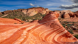
But wow, when we did get there, the Fire Wave itself was extremely cool. Set on the edge of a sandstone monolith that rose out of the surrounding landscape, the pattern was discernable and nothing special from above. But, by moving just a few dozen feet down, into the wave itself, the perspective changed into a magical swoosh that we sat and enjoyed for longer than I think either of us planned.
As we'd driven through Valley of Fire, one of the things we'd noticed was that there were no camping signs everywhere. Unlike the BLM land we'd been on the last several days, the increased visitation to the state park meant that camping was only allowed in the designated campgrounds, and of course that was of little interest to us. Instead, we headed further south and west - back onto BLM - into the Muddy Mountain Recreational Area via the Bittersprings Backcountry Byway.


As had been the case the previous evening, my hope was that we could perhaps do a short hike prior to finding camp for the night, and position ourselves well for the following morning. The plan would require reasonably good roads - so we could make reasonably good time - to the trailhead, and we were happy to discover that for the most part the roads were in pretty good shape - with a few fun-but-not-difficult sections thrown in!


It was 5:15pm when we arrived at Buffington Pockets for what would be our fifth hike of the day! Clearly, the abbreviated timeline of the trip had lit a little fire under our bums, and squeezing in as much as possible was the order of the day.

The trailhead here starts off at a concrete dam similar to The Cistern that we'd seen in Gold Butte National Monument. The obvious difference was that someone has painted an enormous owl on the face of this structure - once again raising the question - art or vandalism? (Hint: it's the later, though that doesn't mean it cannot be the former as well.)

In normal times, the hike up this wash is simple - you climb the wall next to the dam, and then hop down the other side into the reasonably dry stream bed. These however, were not normal times. With nearly an inch of rain in the previous 48 hours, we arrived at the top of the dam to find it nearly overflowing with water, the wash collecting runoff from many of the surrounding hills.

Still keen to make our way up-wash, we looked for a bypass to the south - a class 3 climb, up and over the southern escarpment and then down into the wash 1000' above the dam. It took some doing to find a passable route, but find one we did, enjoying the high views in the process.

Once down on the other side, we almost immediately stumbled upon ruins as we headed up the wash. These are likely more recent than any of the Petroglyphs we'd been seeing, but we still wondered about their history, and why in tarnation the structure had been built in the mouth of a side wash!

Our stroll up the wash was a fun one. Narrower than some of the other washes we'd been in on the trip so far, the terrain alternated between washed gravel and polished stone, some places mixing textures for even more variety.


And then, our eyes constantly peeled, we stumbled upon that which we'd been seeking - a well-preserved petroglyph panel a dozen feet off the ground.


This section of the wash had several panels and we spent a few minutes poking around, joyous exclamations of discovery as one or the other of us would find another panel.  Eventually of course, we remembered the time, and that unlike our previous evening's hike, we were not currently parked in our camp site - so we headed back the way we'd come and found the truck bathed in evening sun as we returned over our cross-country route around the dam.

Back on the Bittersprings Backcountry Byway, our evening's destination wasn't far. As we ticked away the miles, rising and falling with the undulating land, we got glimpses of what we hoped would be one of our most dramatic hikes the following morning - rocky outcroppings of alternating red and white sandstone.
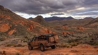

To windy conditions we pulled into what we'd decide was camp right around 7:15pm - we'd made it! Dinner and camp deployment were quick affairs, and we had them completed before the last of the light left the Muddy Mountains around us. Cloudy skies meant there wasn't much of a sunset, and windy skies buffeted the tent as we took refuge in the truck to read and download photos for an hour or so before climbing into bed.
Thankful for our earplugs, and a weather forecast that called for wind-but-no-rain, we did our best to grab some shut eye between particularly gusty moments throughout the night. Those moments - along with excitement of what the next day would hold - meant that this would be the worst night of sleep for the entire trip.
It would of course, be worth it.

")


