
The rain that had started just as we crawled into bed persisted throughout the night - a consistent patter on the tent, its rhythm never letting up. This was no surprise, really - near enough to town that we had cell service, we'd seen that several flash flood warnings were issued for the area, and we hoped that we'd be able to continue our adventure in the morning. In no rush to get up in the deluge, we lingered in bed an extra hour or so, hoping that the forecast - which was for rain the rest of the day - was completely wrong.
Note: it wasn't. Forecasts for the next 10 hours are generally right.

Once we'd resigned ourselves to the fact that hoping for sun was different than actually having sun, we dressed and set about the job of putting the tent away in the rain. This is - of course - my favorite way to stow the tent. For obvious reasons, really - I mean, the act of getting cold and wet while putting the tent away is great; the water trapped on the tent, stewing all day under the cover is pure goodness; and naturally, the dampness of the mattress the following evening is always a joyous feeling.
Thoroughly drenched even after a record-setting tear down, we huddled in the Tacoma with the heater on to warm and dry ourselves while we re-evaluated our plan for the day - and the remainder of the trip. A check of the news informed us that while the Covid-19 situation was getting more serious, it still didn't seem as though we needed to head home immediately, so we checked the weather to our south and west - the direction we planned to head the following day - and found it to be significantly drier. That meant skipping a couple cool hikes and a visit to the edge of the Grand Canyon at Whitmore Overlook, but it would also put us in better shape to finish much of the rest of our it's-always-too-full itinerary before heading home.
So south we went, into Arizona and down the road that leads to the old Mt. Trumble schoolhouse, the views...a bit limited by the fog and rain.


This road - the Mt. Trumble Loop Road - is generally in pretty good shape. It's wide and well graded given the (relatively) heavy travel it sees - but like many roads in this area, its nemesis is continuous rain. You see, while a little rain is great at keeping the dust down, a lot of rain turns that same dust into a sticky, gooey, slimy, muck that quickly clogs up even the most aggressive mud terrain tires and leaves you slipping all over the road.
Undeterred, we pressed on, the fog lifting at times to give us just a glimpse of the beauty around us.

The mud though - while not constant - was relentless. We were clearly the first along Old County Road 101 which would take us from Arizona to Gold Butte National Monument in Nevada, and even in the nice yellow dirt, we were leaving our mark.

In the red dirt - clearly the dirt of the devil - the mark was left on us. And this - I remind the regular reader - is after I changed wheels to solve the mud problem.

We'd covered 30 of the 80 miles on our westward journey when we hit what would turn out to be our sketchiest mud patch of the day. As we powered through it and finally out, I stopped the truck to take a look at the map before continuing on. And then, I looked back the way we'd come. And no, I hadn't been drinking.

The remaining 50 miles wound its way through washes and over Whitney Pass, and we had no idea if we'd make it. With the rain continuing to fall at this point, we decided it was in our best interest - as a single vehicle - to retrace our steps and enter Gold Butte National Monument from the north. We'd later discover - as we talked with a NPS ranger also out exploring Gold Butte - that we'd turned around just after the muddiest section of the road. The rest of the route, he said, was much rockier, including the wash.  You win some and lose some I guess, and in the end, it didn't matter since we still had a great time!
So, it was back the way we'd come and then west to Gold Butte National Monument. Established on December 28, 2016, the monument was created at the same time as Bears Ears National Monument and now encompasses nearly 300,000 acres of land featuring a a collection of intriguing destinations including rock art, sandstone towers, the always-amazing red rock, and several historical artifacts from previous residents.
Just a few miles west, the weather was still cloudy, but it was mostly not raining - a nice change - and since it was lunch time, we pulled over for a quick bite to eat along the side of Gold Butte Road, the landscape rising up around us toward the clouds.


The road into Gold Butte was paved at one point - many years ago - and was a mixed bag as we climbed back in the truck for the remainder of the journey. On the one hand, it meant that there was mostly no mud on the way into the monument. On the other, the potholes - from years of neglect - were so bad that mud might have been less torturous!
Still, cresting the final hill before entering the valley surrounding Whitney Pockets was a fabulous experience - the colors of the rock pockets punching through the dreariest of gray and reminding of the omnipresent silver lining of any adventure!


Pulling up to Whitney Pockets, we were surprised to see a NPS ranger's truck parked just off the side of the road - we were after all on BLM (rather than NPS) land. And, as we were parking the truck in a nearby pull-out, the ranger - Greg - came walking out of Whitney Pockets to say hi. We chatted for quite some time - 20-30 minutes - about all sorts of topics related to the area, and it was during this time that he informed us that we'd made it through the worst of the mud, apparently twice, earlier in the day. Greg was great and regaled us with crazy stories of the Bundy's and his experiences with them. You see, it turns out that their ranch is just north of Gold Butte National Monument that we'd driven right by without noticing - something we'd have to remedy on our way out. Eventually Greg took his leave and we turned our sights to exploration of the pockets area.


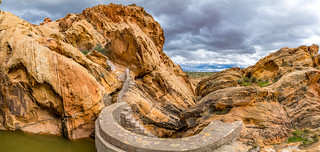
The highlight - at least as far as I know about - of Whitney Pockets, is a cistern built by the CCC. Tucked into the rock outcropping, it captures rainwater behind a dam, presumably for use through dry months. Greg had informed us that it held more water - some 5 feet or more - than he'd ever seen, an indicator of how much rain we'd gotten in the last 18 hours!
A short slot in the canyon led to our first view of the cistern, and the steps that led to its top. The risers on these steps were surprisingly tall, making the experience of climbing them more ladder-like than stairs!

From atop the cistern, we took in our surroundings. Under normal circumstances, it's my understanding that you can continue up the canyon behind the dam, but there was no way that was happening today. The views from up here were dramatic and we spent a good amount of time hopping around to find the best perspective.


By now, it was squarely mid-afternoon and though I'd planned to have us camp in the Whitney Pockets area, it was clear that we still had a few hours of light that we could take advantage of for exploration and discovery. After a quick discussion, we decided that our best bet was to head out towards a group of hikes we'd planned for the next day, perhaps knocking one off the list before setting up camp for the night. So, back in the truck we climbed, and through the eye-turning rock, we continued.

Our first stop - one that I knew was going to be a quick one - was at First Rock petroglyphs. So named because this is the first rock outcropping along the road, the petroglyphs here aren't all that amazing, but the enormous raptor nest is!


Within fifteen minutes, we'd fully explored the site and were back in the truck, making our way south along Black Butte Road for several miles. Our destination was a reasonably short hike several miles away: 21 Goats Petroglyphs. Located up a short side-wash off of the road, we found the very lightly visited trailhead reasonably easily, just as a few drops of rain started to pelt the roof of the truck. 
Hoping the weather would pass, we decided that with three hours of light remaining, this would be the perfect time for a nap. Perfect because any time you can take a nap is the perfect time for such a luxury.  So, out came our Kindles and we read and rested our eyes for an hour or so, as drops continued to fall from the fast-moving clouds overhead. Finally, around 5:30pm, I looked to my right and suggested that we might as well just give it a shot - even if it was still raining lightly.
We climbed out of the truck, donned our rain coats, and started up the wash. Purely by luck, it stopped raining about three minutes later!


The hike to 21 Goats was not difficult - at least as our hikes go. We followed the wash for a mile or so, keeping our eyes out for the rock art that we knew was hiding somewhere along its banks. Then, as we rounded a curve, I happened to glance out of the wash to a nearby rock face - and there was the panel! Excited, we headed over to take a closer look.

Now, though the name of this panel is 21 Goats, the petroglyphs here are actually Bighorn Sheep, and there most definitely are not 21 of them - there are closer to 30. Or more. Not to mention all the other figures and patterns that were painstakingly chipped into the sandstone face - all quite well preserved through the passage of time.


Being the first really nice panel that @mrs.turbodb had seen on this trip, and given that we didn't have anything else planned for the day, we were in no rush and spent a good amount of time admiring the work, as well as discovering a few other petroglyphs on nearby outcroppings.

Eventually though we decided that we should head back - to try and get dinner made and cleaned up before it got dark - and so started back down the wash towards the Tacoma. The trip back was just as pretty as the trip up-wash, and we stopped frequently to admire our surroundings.


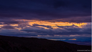
Back at the truck we had a decision to make - it was clear that we had about 20 minutes before the sun went down, and we could either use that time making dinner, or we could head over to the summit of a nearby hill to enjoy the little bit of sunset that it looked like we were going to get - the clouds just starting to clear along the western horizon. Perhaps predictably, we opted for the later, knowing that dinner could wait, but a sunset wouldn't!
I'm pretty sure we made the right choice.

With the light dim, I set about deploying the tent - still wet from the night before - as @mrs.turbodb setup the kitchen and got dinner started. It was, again, a dinner of tacos and guacamole, and boy, were they tasty! A warm light breeze blew through the wash as we cleaned up after dinner, helping to dry the tent quickly. We did a bit more reading and I transferred photos from my camera to computer before calling it a night and climbing into bed.
For a day that had started ominously and wet, we'd gotten quite a variety of experiences and several unique sights under our belts - it had been a great day. Little did we know as we fell asleep under the clearing night sky - the next two would bring adventures even more special than today!
")


