
It was a chilly night at 5300', but our strategic position behind the ridge line meant that we were unaffected by the bulk of the wind - a knit cap enough to keep me cozy, and @mrs.turbodb wanting only for her earplugs in the morning when the birds started singing.
And it was early when they did - sunrise was at 5:07am, and the first light on the horizon started well before 4:30am, spreading across the sky in its glorious trek.


Eventually, there was enough light to illuminate Imnaha Canyon below us - the hills and valleys unfolding into the distance. It was the perfect time to climb back into the tent for another couple hours of sleep.
As one does.


It was closer to 7:30am when we finally pulled ourselves out of the tent for breakfast and a bathroom break, the tent now warm from the morning sun hitting it on three sides. As usual, we split up the morning tasks of breakfast and camp break-down, so it wasn't long before we bid farewell to what I can only imagine was the best camp site on the ridge, and headed back towards Buckhorn Lookout, the Wallowa mountains rising in the distance.

Having spent a few minutes at the lookout the evening before, there was no great surprise when we pulled up to the unassuming 14-foot-square building placed only a couple feet above the ground when it was built in the 1930s. Unlike most lookouts, Buckhorn is perched on the edge of Hell's Canyon - giving it commanding views of its surroundings - the Seven Devils, Hat Point, Zumwalt Prairie, and Wallowa Mountains, all visible along the horizon.
Still, unlike the evening before, the sun was out in full force and though the lookout is no longer staffed, it wasn't hard to imagine what it'd be like to spend a spring and summer here, amongst the wildflowers and views.


A bit of exploration - @mrs.turbodb reading the signs and the great descriptions in 100 Hikes / Travel Guide: Eastern Oregon, me checking to see if any of the boarded-up windows were loose so we could get a peek into the lookout  - and we decided it was time to move on. All of our progress the previous day meant that today was going to be a little awkward - and either very short or a tad long as we tried to get back into a routine.
And we generally have a hard time with short days, a habit we've developed as we try to squeeze as much as we can into our long jaunts from home. Our next destination was the little town of Imnaha - south, and some 3500' lower than our current elevation - where we planned to turn north again on our way to Dug Bar.
I'd put together a track for this portion of the trip, and unknown to me at the time, it took us through the vast Zumwalt Prairie. When I say vast, I mean seriously vast - 330,000 acres. And to see it when we did - at the height of spring - was something special. Green grass as far as the eye could see.


Elk at the treeline.

Halfway or so through the prairie, we came to the road I'd marked that would take us down into Imnaha. A fence-line road, it was clearly less traveled than the well-graded FR-46 that we'd been on to this point, but that wasn't what caught our eye as we pulled up to the gate. Rather, it was the lock that had us pondering our next move.


This of course is one of the drawbacks of using Google Maps/Earth to create a track - the work you do can look great from a satellite image taken years earlier, but who really knows what you'll find on the ground! While we were unsure wheather this was a new lock (which it looked to be) or if this was never a passable route, we took a look at our maps and decided we could take a reasonable re-route through the Zumwalt Prairie Preserve, so we headed that direction.

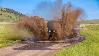
This reroute - it turned out - had a few highlights in store for us. With plenty of recent rain and snow melt, there were some reasonably sized puddles on the road - a temptation that few truck owners would be able to pass up.
And I'm not one of them.


After this little run, we noticed a couple birders on the preserve with their binoculars pointed in our direction. It was, we like to tell ourselves, the highlight of their day as well. 
The truck a bit cleaner - or rather, less muddy but now covered in a thin film of dirty water - we continued towards Imnaha, the road much less maintained than FR-46, but still easily passable for us without airing down. And then - traffic!

I knew immediately that what we had in front of us - I mean, besides a 2nd gen Tacoma - were a couple of birders. I've been around Pops long enough to recognize the speed, braking pattern, and arm pointed out the window toward some seemingly-meaningless underbrush. Probably containing a bird.
We coasted along behind them for a while until they got out - binoculars in hand - to observe what was probably a rare find - likely a flockus aroundus, or the ever elusive hideus-inthebush-us. At that point, they noticed us and proceeded to pull over after carefully observing what I could only hope was a life bird.
Once again making good time, it was now @mrs.turbodb's morning nap time. As such, I shouldn't have been surprised that as we rounded a corner and I exclaimed, "Wild Turkeys!" she nearly jumped out of her seat.
"Oops."

We passed through Imnaha not much later, stopping only briefly to take in the town - captured here in it's entirety - and some stunning California Poppies.


As I mentioned before, our plan at this point had been to turn north out of own along Lower Imnaha Road towards Dug Bar, but some atypical quick thinking on my part and we decided that a better idea would be to head south. That would take us up Hat Point Road, to elevations above 7000' where we expected to be stopped by snow. Rather than end up there at the end of the day and have to camp in the cold, it seemed to be a good idea to do that first, and then camp at Dug Bar's much warmer 1900' elevation.
So, we continued south, and the climb into Hells Canyon started immediately.

The climb of course afforded us more amazing views of the mountains and valleys, and in typical fashion, we began our slow trek through a new place. Each bend offering something we just had to stop for.


And then, at 5400' we hit our first patch of snow. With 1600' more feet to go to Hat Point, it wasn't looking good. And our case wasn't helped when we ran into a Forest Service employee a couple miles later who informed us that, "In that truck, you'll make it as far as anyone can, but you aren't going to make it to Hat Point."

Determined to make it as far as we could - or rather, just short of that so we didn't get stuck again - we continued on. An overlook of Upper Imnaha Valley provided a great spot for a poser shot, and would later be the perfect spot for us to enjoy delicious turkey sandwiches as we took in the view.


Amazing what a little perspective shift can do.
Up and up we continued. 5800', 6000', 6500' - the snow was becoming more plentiful, and the temperatures were dropping - we were glad that this wasn't going to be where we camped for the night. But the views continued to get better - the Seven Devils finally showing themselves as we crested the second-to-last ridge before reaching Hat Point.


But it wasn't long - perhaps only 2-3 miles - after we passed Saddle Creek Campground and it's dozens of bear hunters, that the white stuff blocked our path. Could this be Hells Canyon and the Seven Devils just toying with us? At 6666' feet on the GPS, it was, if nothing else, a fitting stopping point.


We got ourselves turned around and started back down the road - pausing once again when we noticed an entire hillside covered in Glacier Lilies - framed by the Seven Devils, a sight to see.

And with that - and a bit of lunch - we headed back down the hill towards Imnaha - the 80°F warmth of the valley beckoning us down out of the 55°F mountain temps.


... to be continued ...
 Day 1 (May 2019)")

