Doing our best to put the failure of the tent zipper behind us, we left the Glass House in the rear view mirror and set off on our exploration for the day - to visit several old homesteads I'd found on satellite maps around Hart Mountain, just to get a better sense of the terrain in a place we've not previously been.

It was looking a little ominous to the south, with plenty of snow on the Warner Mountains.
The first structure I'd discovered wasn't very far away, but I was surprised when - less than 15 minutes into our journey along Rifle Canyon Road - we came upon a cabin in the tall grass. I hadn't noticed this one at all when I'd been planning the route, but even with cold temps and snow on the ground, I was happy to get out for a walkaround.

A nice surprise.

Probably doesn't fare so well in wet weather.

Could use updating.
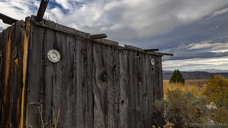
All in all, this cabin was in what I would call typical shape for a place found out on the edge of the Hart Mountain National Antelope Refuge, which is to say "not great." The most interesting bit to me was that over the years, it had obviously been attacked by woodpeckers, and for at least some amount of time - when there was a human resident - the battle had been valiantly fought.

Tin can lids were used to patch woodpecker holes... for a while. Now, the woodpeckers have clearly prevailed.
Back on the road, we wove our way in and out of the reserve over the course of only a mile or so before coming to the second structure of the morning. I'd marked this one as an "old shed" and was delighted to discover that I'd been correct in my assessment. Obviously associated with a nearby paddock and grazing area, I suspect this is where the resident of the house we'd visited kept their stock.

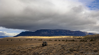
The setting, at the base of Hart Mountain, was definitely dramatic.

I really liked how the siding on this barn sort of faded away from left to right - not due to time, but rather, by design.
Stopping only long enough to snap a couple photos - my passenger, preferring to stay warm in the heated cabin, didn't even exit the vehicle for this one - we were back on our way in just a few minutes.
Travelling only another couple miles before reaching the first significant homestead of our day, this one was different than the others. Situated a little further off the road, Fisher Ranch one was composed of a gaggle of buildings, with fences, corrals, and vehicles strewn about. In fact, at a distance, both of us wondered if it was still occupied - a question that was easily answered as we drew closer.

Apparently, this is not a heavily trafficked route.

Nice views along the edge of valley.

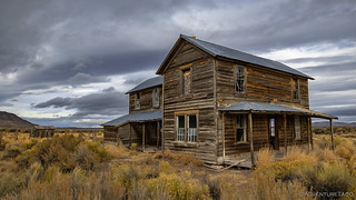
The main house at the old Fisher Ranch.

This circular corral was pretty cool.

The old ranch truck. If you look closely, you can see that steering wheel and pedals have been moved, giving it rear-wheel steering and dualies in the front.

The Tacoma can't win many races, but would stand a chance here.
After inspecting the interior of the main house and poking around in a couple of the old workshops - where not much of interest remained, everything having been picked over through the years - we retraced our path just a bit. Our goal - to climb to the top of the Hart Mountain National Antelope Refuge - meant summiting not Hart Mountain itself, but its neighbor to the south, Warner Peak.

At the base of the mountain, we discovered this Oregon Central Military Wagon Road (1864).

As we climbed, the trails were "signature Oregon," with softball size rocks that rattle your bones. And a big rock here and there (but you don't have to drive over those).

Into a high valley.
Warner Peak and Hart Mountain - like Steens Mountain to the east - are part of a fault block range (see this diagram). Heading up the more gradual side of the range, elevation gain came in fits and starts, broad meadows making for an almost imperceptible climb. And it was in one of these meadows that our attempt to summit was abruptly halted!

A welcome patch of sun stood between us and the cloud-covered summit of Warner Peak.

Dang!
Closed roads are just a part of any backcountry adventure, and though we were surprised to find that this area had been closed for restoration - it wasn't mentioned anywhere on the Refuge's website - I think we both breathed a small sign of relief - @mrs.turbodb because it meant that she needn't worry about the snowy road conditions; me because I was getting hungry and we still had a good couple hours to the top of Warner Peak. 
With that, we got ourselves turned around, and headed east - our hearts set on even more homesteads, just over the horizon. And lunch.

Even on this cold (and becoming windy) day, we got some pretty great views.

The red clay playa of Wool Lake was striking.
It was 12:30pm - and temperatures were warming just enough to soften the road surface, threatening to turn it into a muddy mess given the snow we'd received the previous night - when we stopped for lunch near Jacob's Reservoir. With the truck angled into the wind to make sandwich assembly and consumption as pleasant as possible, @mrs.turbodb set about with the assembly while I took a few minutes to investigate a small cabin we could see just a short distance from the road.

Looks to be in reasonable shape.

On closer inspection... Needs windows. And doors. A roof would be nice.

I thought the weathering of the siding was beautiful, if a little drafty.
Heading back to the Tacoma, I arrived just as our salami sandwiches (and Cheetos) were ready to eat, and boy did they hit the spot. Both were nice as a bit of variety from our usual tuna and Lays, though both of us also agreed that eating all that orange powder should remain a once-in-a-while indulgence.
An Unexpected Aside...
As with the previous chapter of this story, some of my favorite moments of a trip are discoveries of something unexpected.
If you know where this hot spring and these petroglyphs are, please keep their location special. Doing so will help to preserve them for future visitors who are willing to put in the time to find them!
We really couldn't believe it when we pulled up on ██████ Hot Spring. I'd marked it as something that "looked interesting" in the radar imagery along our route, but I'd not realized how awesome it actually was. In fact, even as we pulled into the parking area, I don't think either of us really expected that we'd spend more than half an hour prepping the tub for a soak.
That is, until I felt the crystal-clear water that was piped from the source and realized that it was the perfect temperature for this rather cold day. Oh, and there's the fact that hot springs are - seriously - @mrs.turbodb's absolutely most favorite thing!

The source didn't look all that compelling - with not much steam, we thought it'd be luke warm at best.

It turned out to be clear, not too smelly, and when mixed with a little cool water already in the tub, a perfect 105°F! Pure bliss.

A good rule for all of life.
Unrelated, we also came upon this rock, covered in rock art from two distinct time periods. Two unexpected petroglyph sites in two days! 

We never really figured out the meaning of "Look up on that rock."
With the wind picking up and the temperatures dropping, eating was a rather quick affair. It was as we climbed back into the heater-blasting-warmth of the Tacoma that I realized we ought to listen to the weather station on the ham radio, just to make sure there wasn't some crazy storm blowing in.
I'm sure you can see where this is going.
The excitement - as though it was Christmas - was palpable for the weather station. The droning robotic voice read wind warning after high wind warning. "Stay indoors." "Stay away from trees." "Unsecured objects may become dangerous." "Remain on the ground floor." For the next 18 hours, winds were projected to rise to 40-50mph with gusts to 65mph. And - of course - there was rain too.
It was - as you can imagine - exactly what we wanted to hear, given our plans to camp in a fabric tent high off the ground, on a surface that becomes a muddy mess at even the hint of rain.
We pretty much decided at that point that we'd finish our exploration for the day, and then bomb ourselves home. It wasn't ideal, but it was better than the alternative.

Not a good place to be caught in the rain.
Luckily for us, the roads here in the area south of Hart Mountain were in reasonably good shape. Still a bit muddy from the melting snow, the brisk winds and dropping temps were quickly drying them out and firming them up. As such, it wasn't long before we were dropping down from one plateau to another, nearly to the Shirk Ranch.

Even on the final approach, the Shirk Ranch was mysteriously absent.

We've arrived.

The main house. Two full stories.
Shirk Ranch was originally homesteaded by the Hill family in the early 1880s, during the initial settlement of Lake County. According to the site’s National Register nomination, David L. Shirk purchased the property in 1883 and, around 1910, built most of the buildings and structures standing today.
Shirk was a well-known cattleman - he had assisted with the first drive of Texas cattle to Oregon back in 1869 and reportedly held up to 50,000 acres of Oregon rangeland. But this ranch in Guano Valley was different. It wasn’t a cattle ranch.
Shirk purchased the Guano Valley site as a horse ranch and wrote that he “at once began improving the property to accommodate a large number of horses and mules.”
“These I raised myself, shipped to market, . . . and sold them,” he wrote, “and in this I did fairly well.”
Horse raising was a key industry well into the twentieth century, before the automobile and mechanized farm machinery were widely available. Demand was high. Oregon horses raised by stockmen like Shirk even ended up at war on two foreign continents, supporting military actions in South Africa’s Boer War and, later, World War I in Europe.
Family was essential to Shirk’s ranch operations. “I and my family, including my wife and children, were almost constantly in the saddle, doing our work and lessening expenses,” he wrote.
Shirk also relied on the help of ranch hands. “I endeavored to secure as employees the better class of young men,” he wrote. “I had constructed an elegant country home, and all were treated as equals. They ate their meals with me and my family, and in other respects were treated as equals.”
Shirk sold the property in 1914. In 2009, the ranch was entered into the National Register of Historic Places in recognition of its national significance. Today, the BLM administers it for public access.

In the kitchen, the sink was significantly fancier than what I've seen elsewhere.

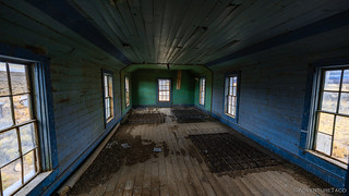
The downstairs living room.

Upstairs, this room was used as a billiard room, where Shirk wrote, "I placed therein a modern billiard table for their amusement during times of idleness and the long winter nights. I had a two-fold purpose in this. First, because I believe that every man is as good as any other man, provided he is honest, industrious and conducts himself as a self-respecting man, and also, because I sought by this means and by such methods to secure contentment and steadiness on the part of the men in my employ." (Greg Shine)

I thought the chimney pipe was... interesting. The clay segments are most commonly used as sewer piping.

A two-hole pooper, a little worse for wear.

The water tank still perched high off the ground, its rock walls slowly crumbling before it falls.

Near one of several sheds, this old sled was likely once pulled in the winter by Shirk's horses.
We spent a good half hour or more wandering around the various buildings at the Shirk Ranch. Like others in the area, there isn't much left from a "stuff" perspective - that's all been gathered up by previous visitors, though such gathering is illegal - but the sheer number of buildings, and the obvious care with which they were once treated, was quite impressive.
And, it was quite the contrast to the next homestead we visited - the Spalding Ranch. A main house and single stable were all that remained here, and they were in pretty rough shape. I don't know for sure, but I think that once a building gets to a certain state of disrepair, the respect shown for that building drops off dramatically, people who might normally admire, suddenly compelled to write their name on the wall, or throw a rock through a window. Bummer.

The main house of the Spalding Ranch, the chimney having fallen sometime since 2013.

Inside, chalk "pictographs" adorned the pine walls.

At one time, this too was a very nice residence. I've never seen a homestead with baseboard, but this one sported it in every room.

Today's resident.

Outside, an old well was lined with volcanic stone, gathered from the surrounding valley.
With that, we'd wrapped up the list of buildings and homesteads I'd planned to visit and with only a couple more hours of daylight, we began a long trek north through the Refuge. This wasn't part of the original plan, which had been to head south to highway 140. But, having been turned around on our summit attempt at Warner Peak, and knowing that we weren't going to spend the night, I suggested that this alternate route would give us a second chance at the peak, and would likely take us approximately the same amount of time... assuming it was passable that is!

We got a good laugh out of this pair of signs. I suppose that UTV riders may need them both. 


As we headed north, this flock of "white birds" was headed in the opposite direction. A sign, perhaps.

Where we'd previously attempted access from the south, we now approached Warner Peak from the east.

Alas, just as with our earlier attempt, this one was blocked! No summit for us. 
Continuing north on Barnhardi Rd, we skirted the east side of Warner Peak and Hart Mountain, the road getting slushier and the snow getting deeper - but nothing even remotely noteworthy - as our elevation increased to 6900', the highest we'd been all day. Along the way we passed through Guano (currently closed for restoration) and Hot Springs (where we stayed on our first visit to Hart Mountain) campgrounds, as well as a couple of headstones commemorating two more soldiers who'd died in this area.

Edward Cantrell | Sgt Co B | 23rd US Infantry | 1846-1867
Lewis DeBold | Pvt Co D | 14th US Infantry | 1847-1866

This aspen grove would have been spectacular just a couple weeks earlier.
In the end, the roads all ended up being in reasonable condition and we covered the ground to the Hart Mountain Visitor Center in a little over 90 minutes, arriving just after it closed at 5:00pm. As the winds continued to pick up, we aired up the tires for the 600-mile trip home and tried to figure out our dinner plans. We had options, but none of them were good, this part of Oregon not known for vast variety of eateries. In the end, we choose what was the easiest - but not necessarily favorite - option, McDonalds in Hines.

A final show as we ran from the weather.
It'd been a great trip to an area that we've previously been near but never to. And of course, the unexpected bits - hot springs and rock art - made it all that much sweeter!


I guess the Spaulding Ranch was visited by the ChalkTalk Tribe, LOL. Another very interesting adventure with plenty of points of interests and beautiful photos and just a few "closed" roads. Even here I've encountered a couple of "road closed for restoration," signs when driving some dirt roads a few weeks ago. There are a couple of wildlife refuges that I didn't know existed out here.
So, thanks for more fine entertainment!
Hahaha, I love that - Chalk Talk!
The roads being closed is a bummer at the time of the encounter, but in the end, it seems like it's probably the right thing to do if we want to keep our natural lands "more natural." I know that's not the view of many - who feel like they have every right to do whatever they want on our public lands - but I personally view them as a privilege - one that we have to look after.
As always post card quality photos. Not many are like us that have the desire to travel and explore. Your stories and photos are very much appreciated by many who can't get out and do the same. Thanks for sharing!
Boy howdy you got lucky dodging the rain and snow and no dust.
We were very lucky with the weather - not so much for the weather itself, but for the resulting mess that would follow on those roads (as you know better than anyone)!
Our time in the area is done for now, but I'm already looking forward to spring (probably after memorial day) when it all greens up and we can head back!
Continuing the great story and I very much enjoy the ride along. One day, I will follow you into these areas!!
Thanks Bill! Always nice to have you along!
I know that I've probably said this before, BUT, yes when I encounter a closed road/trail or have to deal with getting on a waiting list or get a permit to hike an area, etc. I'm a little irritated BUT I also realize that with the huge increase in the past several decades of people wanting to get out into the great American wilderness has made it necessary to place some limits as to when and how many people can be allowed into areas at a single time or over a period of time. Some years ago, when I made my last visit to Yosemite National Park, I thought I'd hike the Half Dome trail and what I encountered was horrific. The trail was packed, literally, shoulder to shoulder with people making the hike up AND the same for those coming back down. It was like one slowly moving snake or being in line at Disneyland for a popular ride. Half way up I just got fed up and turned around, left the park and ended up in the Eastern Sierra visiting some of my favorite trails instead. The entire Yosemite Valley was like a giant parking lot. Something clearly had to be done! One more reason I enjoy your adventures so much, you go places that are less traveled and where many of us would never see if not for your posts!
Another great adventure with spectacular photos! I love those old homesteads!
We did almost the same exact route in 2018 on our dualsports. We visited Glass House, camped at the old homestead you had lunch at, skipped the hotsprings as there were people there, Shirk Ranch but then headed out to Alvord and Rome. Great area.
nate
The hot springs are my favorite Hot springs. If you would have went on 140 twords Lakeview you could have went to Drake's peak a fire lookout that you can rent to stay the night or just go to enjoy the view of three states. Oregon, Nevada and California. Or north of plush when you came in on the hogback you could have went to the sunstone area and found Oregon diamonds. Lake county is awesome. I grew up in plush and now live in Lakeview. Hope you come back and see more.
Glad you enjoyed it Teresa, and thanks for the tips! Lake County is definitely a great spot, and we'll surely be back. I know a big fire went through there over the summer; how are things these days?
PS - hope you got to enjoy the rest of this trip as well - we had a great time! (see Hart Homesteads)