
With little wind - or with our position sheltered from the worst of it - at the mouth of the wash, sleep came easily and was welcome after the sandy miles we'd put on our personal odometers the previous day. As with every other morning, my internal alarm kicked in a few minutes before the electronic one, and soon enough I was climbing the hillside behind camp in order to get a shot of our surroundings.

Camped on the edge of wilderness.

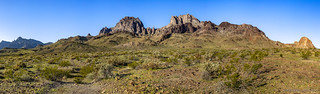
Table Mountain in the distance, bathed in morning glow.
Being that we were in no real rush at this point, I wandered around above camp for a good 30 minutes or so before picking my way back down the hill to a still-warm-under-the-covers @mrs.turbodb and poked my head into the tent to let her know that it was getting up time. By now, the sun was streaming down on side and top of the tent, quickly drying out the bit of ice that'd formed overnight, and soon we were both up and about. Leisurely attending to our morning routines - and of course, enjoying some morning Duet bites - we didn't pull out of camp until just before 9:00am!
What is this world coming too?

As we pulled out of camp, I hoped that the patchy clouds would continue to add visual interest throughout the day. Only time would tell.
Whereas the previous three days had been spent in the Mojave National Preserve, today we'd be heading south - into the Turtle Mountain Wilderness - in search of some mining ruins and the legendary "Blueprint" petroglyph.
Surely, it was the latter that piqued my interest in this place as I planned the trip. I'm not sure exactly how I stumbled on it, but I'd read a trip report by "Jonathan Pusey" (aka ███████████) who'd visited the location a decade earlier. The description - and the fascination it described - were contagious, and after a few hours of searching my back issues of Desert Magazine, I triumphantly mapped what I thought would be a series of roads and hikes that would lead us to the singular petroglyph deep in the wilderness.
We became fascinated by the Blueprint Petroglyph. In an issue of Desert Magazine that you, dear reader, may find for yourself, we found a photograph of and detailed map to it. "How hard could it be?" Well, aside from the [roads] being closed through the Turtle Mountains Wilderness, we have photos...
Sorry, I won't give you explicit directions to the Blueprint Petroglyph. I'm hesitant to post this at all for fear of "outing" it to the digital world. I must set the tone, however, so you can get within a half mile of it by following along. You may walk right up to it if you find the map in Desert Magazine..."Jonathan Pusey"
As we pulled off US-95, the Turtle Mountains rose dramatically in the distance - and they were so green!.
Deciding to leave the petroglyph hunt for the afternoon, we pointed the Tacoma south in search of another point of interest I'd taken note of in the same magazine article - a "boulder house" - as well as some old ruins I'd spotted on satellite imagery.

Balanced rock.
To this point in the trip, we'd hesitated to air down, knowing that we'd be transitioning between dirt and pavement several times throughout our journey. That made for slow going here, the grading budget for the Turtle Mountain Wilderness significantly smaller than that of the Mojave Preserve. Still, we didn't mind the pace - the scenery around us was spectacular - and it's not like we ever move all that quickly with my stopping incessantly for photos.

A blooming Beavertail Prickly Pear, the first of several we'd see, and the only variety of cactus with flowers on this trip.

The cholla blooms weren't far behind, but for now they looked a little wormy.

One of the roads we'd planned to take - turned out to be recently closed by the Bureau of Land Management (BLM). No worries, our legs were still legal.

I'd seen this rock foundation via satellite and hoped that the walls were a bit taller. Not that the devil's cholla needs any protection...
Only a little more than 7 miles long, it took us nearly an hour - one full of braking and bumping - to reach the end of the boulder house road. Constantly checking our map against the one we'd found in Desert Magazine, it wasn't until we reached the end that we realized that we
- had done something wrong in mapping the route OR
- didn't know what a boulder house was OR
- weren't paying attention.
Ultimately - and with plenty of prior experience - my money was on (c). Still, as we reached the end of the road, we decided that we had better look around a bit - just to rule out (a) - and so followed the foot trail for another couple hundred feet until it ended at one of the strangest rocky outcroppings we'd ever seen.

Slow progress on the roads meant plenty of time to soak in the Turtle Mountains.

The strangest grave. Probably just some rocks that some bored wanderer arranged.

While there was no boulder house at the end of the road, this concrete-sack pool full of green algae reminded us of how much we needed to shower.

An outcropping of perlite. (Or so Desert Magazine suggested.)
Not really knowing if we'd stumbled on anything interesting, we enthusiastically engaged in some half-hearted amateur rock hounding - mostly to find a photo-worthy specimen - before heading back to the truck. Of course, not knowing anything means that we had no idea if what we'd found was worthy at all.

Is this perlite? And more importantly, is it worthy?
Before retracing our route to our main attraction - we were here to search for a lone petroglyph after all - we took a quick look at the topo map I'd downloaded in an attempt to place the boulder house denoted in Desert Magazine in relation to the surrounding hills. Reasonably sure that our problem was no longer (a), we headed north, covering the mile of ground between us and the location we'd marked in just a few minutes.

There was no boulder house where there should have been one. There was however a rock that said "GONZ." As in, "The boulder house is GONZ."
Not easily deterred, I popped out of the truck under the suspicion that if the problem wasn't (a) or (c) - given that we were in the right place and paying attention at this point, then it must be (b) - we just didn't know what we were looking for. Perhaps the boulder house was a natural rock shelter, or cave?
I searched for 15 minutes - over a reasonably wide swath of ground - before giving up. In that time, I did find several natural shelters and caves carved into the volcanic hillsides, but none of them struck me as being map-worthy for any more than the packrats that clearly called them home. Alas, we'd struck out.

At least we got to enjoy the Turtle Mountains a second time, despite our failure.
As is often the case, we made better time on the way back than we had on the way out, and soon we were investigating the remains of the Lost Arch Inn.

Won't you join us for lunch at the Lost Arch Inn?
Legend has it that a man named Amsden left Needles in 1883 to prospect in the Turtle Mountain Range. A few weeks later, Amsden staggered into Goffs, close to death but with his pockets bulging with gold. After recovering from his ordeal, he returned to his home in the east. Several years later, it is said that he penned a letter to Dick Colton, a friend in Goffs, with directions and a map to his placer mine in the Turtle Mountains. The letter said the gold was not far from a natural arch.
From 1922 to 1948 a pair of prospectors, Charlie Brown and Jesse Craik occupied a cabin near the suspected Lost Arch mine. While neither gave much credence to the legend of a lost mine, they nonetheless sampled much of the ground around the Turtle Mountains and held many claims, milling what they found on site. In fact, one claim - betrayed by the concrete foundation of their old mill - was one right behind the camp and tested at $3 a ton (for gold and silver).
As well, they welcomed visitors and dubbed their two cabins as the Lost Ach Inn.
Charlie Brown's cabin at the Lost Arch Inn today.
The Lost Arch Inn and Jesse Craik's collapsed cabin next to it, prior to 2018.
(photo credit: Darth Jenni)


Nearby, it was @mrs.turbodb who spotted the cluster of rusting cars. Surrounded by a corral to "keep visitors safe," it turns out that these steel bodies were collected from various locations in and around the Turtle Mountains for scrap but never hauled away. Later - perhaps after a budget cut or two - the BLM decided that they "added to the experience," and shouldn't be removed.

Remember, rust kills. Keep your Tacomas outside the fence for their own health.

Anyone need a fender?

Perhaps a diff?
Whether we'd exhausted all avenues of procrastination or simply saved the best for last, it was finally time to set off in search of the "Blueprint" petroglyph. Our anticipation was rising as we approached Mohawk Mountain and Mexican Hat, two landmarks we knew were along the route to success.

With the sun streaming through the grass, the green hillsides were even more brilliant as we neared the trailhead.

Finding a nice spot to park, I set up the solar panels in a feeble attempt to justify their purchase.
It was just before 3:30pm when we set out towards Mohawk Mountain on the Mohawk Spring trail. That gave us a couple hours before sunset - plenty of time to cover a couple miles and find the "Blueprint" petroglyph around which I'd planned this entire day! Not that there was any pressure. Or expectation. Certainly not. Especially given our failure to find the boulder house. No pressure at all.

Near the trailhead, one of the inclined shafts of the Lisa Dawn Mine had been capped by the BLM.

A little farther on, a boundary marker for the mine.
As we made our way up the gentle slope - along an old miners trail - spring was in the air and on the ground. Like the cacti we'd seen earlier, things were just getting started, and there's no doubt that if we'd shown up a week later, the hillsides would have been bathed in yellow.

Wrapping around the mountain, the views really started to open up.

California Suncup (Eulobus californicus).

Some sort of daisy?
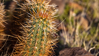
Even the Hedgehog Cactus were prepping for their annual gala.
Eventually, the trail reaches a small saddle, where more modern rock art - likely from the 1970s - decorates a few of the boulders overlooking the valley below. Whether these are graffiti or the marks of those who once prospected these lands,

John's Gap.
Soon, we reached Mohawk Spring. Located on a small spur off of the main trail, it hides behind an old mesquite, in a short tunnel burrowed into the cliff. Much of the rock around it has crumbled, nearly burying the entrance to the now-dry spring.

Nothing in there.

In profile, it's easy to recognize Mexican Hat as the plug of an ancient volcano.
Sure that we were on the right track, having found the spring with little fanfare, Desert Magazine suggests that the "Blueprint" is nearby, and I suppose that's true in the context of the Turtle Mountains or Mojave Desert. For most, however, a "nearby" search will end in disappointment - more walking is needed to reach the ultimate goal.

The walking - even if no "Blueprint" is found - is a pleasure in itself, @mrs.turbodb tried to convince me.

At one point, we found ourselves on the "far side" of Mexican Hat.
After nearly as much walking as it'd taken to reach the spring, we arrived. Having seen a photo of the "Blueprint," and reasonably sure that we'd found the right spot - or close to it - we began our search. From rock to rock, and creosote to creosote we looked for the perfect combination.
Five minutes passed. Then fifteen. Before long, it'd been an hour.
After ninety minutes and several resets of our search grid, the writing was on the wall - or rather, the sky - as we realized that our search for the "Blueprint" wasn't going to end on this visit.

Even in failing to find the rock art for which we'd been searching, we found splendor every step of the way.
With headlamps and flashlights, we headed back to the Tacoma under the cover of twilight. It was a return trip that we'd hoped to make under different circumstances, our talk along the way of where the glyph might be and how we could have possibly missed it. Eventually of course, we arrived back at camp; hungry and tired; ready for a rest.

A day of ups and downs ended with our eyes glued to the glory high above.
The following morning...
Unlike previous mornings where I'd easily climbed out of the tent a half-hour before sunrise, I contemplated staying warm under the covers on the last morning of our trip. Ultimately - after oscillating several times - I finally got up just as the sun was cresting the horizon and kissing the peaks of the mountains we'd explored the previous day.
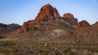
Good morning Mohawk Peak. I see you back there Mexican Hat.

What a glorious day in the Turtle Mountains.
After a couple shots, I returned to bed, the thought of cuddling for a few more minutes with my cozy companion even more appealing in the crisp morning air. Eventually, of course, once the sun struck the tent and warmed the air around us, we got up for breakfast. And then, it was time to head home.

The trips home are so much more enjoyable when they only take a couple hours.
I'm already making plans to return, hopefully in the company of others more knowledgeable than I. Others who have found the "Blueprint," and who can point me in the right direction.


Gorgeous pictures, particularly with the wildflowers in bloom. Definitely a not-frequently visited area...thanks for sharing
Thanks Rob! I have a feeling that the wildflowers were just starting - at least on the prickly plants ? - and would have been spectacular a couple weeks after our visit. The other thing that surprised me was the number of folks we saw out there - not a ton, and never closer than half a mile - but we saw three other campers enjoying this little section of desert. Rockhounds, perhaps.
The desert is especially beautiful this time of year as everything is blooming, just before the big "heat up" when everything turns brown, dead, and HOT. Our trees are blooming as is the sage and other plants but so are the weeks and my hay fever allergy goes nuts making outings a combination of pleasure and misery! But our desert outings will continue until it's just too hot.
Oh yeah, gotta get the last few desert trips in before the heat really kicks in. I'm also looking forward to the melt in the mountains, so we can start getting into the higher elevations again. Can't wait to see what the Sierra is like this year - so much snow, will probably be August before we can get up there!
On that "some sort of daisy" , check out Brittlebrush and see what you think. UJ
Could be Brittlebrush. Some of the photos I see of that have the same eight petals (4 groups of two), but some photos of Brittlebrush seem to have a lot more petals. Is the petal number just a species variant, or does it help with the ID?
Good sleuthing dude. I must tell you, I am impressed (over time) with your attention to detail and in this case botanically. Well, I must tell you...it IS Brittlebrush (Encilia farinosa). As you questioned regarding the petals, they can vary from 11 to 21. A very common and beautiful shrub gracing much of Arizona. Honk, UJ
Hi! I'm currently working on a project for the BLM in terms of wilderness reporting. Was that "concrete-sack pool full of green algae" inside the wilderness?
Hi Nick - As far as I can tell it is not inside the wilderness. I'd love to hear more about your project for the BLM, you've piqued my curiosity!