We wrapped up our long drive south as we turned onto CA-168 from Big Pine. My plan - crazy as it seems now - had been to get all the way to our first trailhead prior to calling it a day, but given that it was already 3:00am and the trip over North Pass and into Saline Valley would take another 90 minutes, it seemed prudent to find camp rather than risk needing to do so in the much colder elevations should the pass be... impassable.
There was no getting up at sunrise. Nestled in a small side canyon and protected from the 25mph winds, we waited for the sun to hit the tent before climbing down the ladder.This guy was frozen solid just behind our parking spot. I don't even know what to say about that.
We turned off of pavement and onto Waucoba Road right around 9:00am, a bit of weather - that we'd driven through the previous day - still hanging over the Sierra. Hoping that weather would confine itself to Owens Valley for the duration of our visit, we aired down to a hazy descent into the north end of Saline Valley.
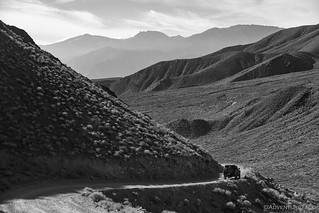
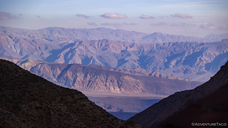
Ghost mountains.Helper.Driving into the sun, the Inyos we'd be exploring were looking rather unincredible.
With only a few hours sleep and having last eaten around 5:00pm the previous evening, I think we were both craving a snack and a nap when we finally hit the valley floor and found our first foray into the Inyos - via one of the canyons.
Into the Inyos.
A nap would have to wait - with only three days to poke around before we had to head home, and sunsets at 4:24pm, we needed to take advantage of the little daylight we had - but lunch was seeming like a really good idea. "Let's do one short hike and then eat," I suggested.
Perhaps this is what happened to the last couple who decided to "explore first, eat later?"
Looking back now we should have eaten first - given my inability to view anything quickly in Death Valley - but instead we parked at the wilderness boundary and headed up the trail. At less than two miles roundtrip, it didn't take long to reach the mine camp.
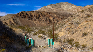
Just past the wilderness boundary, some ATVer used a cutting torch to demonstrate why we can't have nice things.Yep, no ATVs.200 yards past the torched gate, nature narrowed the trail to a footpath - sorry ATV asshole! - as the camp came into view.Looking fancy!
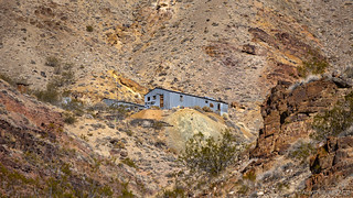
A few minutes later we were climbing out of the wash - the road having been reclaimed since the area was worked - to several relatively recent corrugated-steel buildings. These were later additions to the site, as mining at this location took place in the 1920s and 30s. Still in reasonably good shape, we spent the better part of half-an-hour poking through them looking for treasure; calling to each other as interesting tidbits were found.
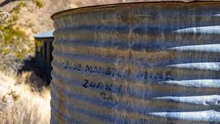
From left-to-right: workshop, residence (kitchen, bathroom, etc.), sleeping quarters, generator shed for collapsed aerial tramway.Extra.This dugout was once a residence - primitive, but cool year-round!A wood stove, artwork, and no rodent droppings in the sleeping quarters!The workshop was the nicest I've seen. While I'm sure the majority of items have been removed, it was clean and still had a few interesting artifacts.An old forge still contained one of the crucibles used to refine the good stuff.These cogs transferred power from an electric motor into a small ball mill.Outside the house, the water tank was apparently "borrowed" from another nearby mine.Currency, Silver, and Checks.
There was one other building - an outhouse. After noticing that @mrs.turbodb spent a little longer investigating it than I thought warranted, I jokingly asking her if she used it, we both got a good chuckle when she answered in the affirmative. Of course, seats make everything easier for the ladies, so I can't really fault her for making use of the facilities (and she still packed out her paper).
Nearing noon, the smart decision at this point was to return to the Tacoma where we could fill our bellies with tuna sandwiches and Doritos. Naturally, it was only @mrs.turbodb who made this decision. I - having spotted the workings of the mine high on the hillside - opted for danger.
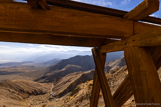
This impressive little mine was never accessed by anything more sophisticated than a foot trail, and [having] been severely damaged by landslides and you will need to guess ... where the trail is.
[Near the top] is a very interesting aerial tramway and trestle bridge, but there is a problem: reaching them safely. They are constructed at the very edge of the cliff, and the trail to it is gone. To get to them, you will need to scramble down a short, slippery talus, and if you do slip you will drop 50 feet or more over the cliff. If you decide to try it, do so uphill from the terminal, so it will stop you in case you stumble. Once you get there, refrain from loitering, and stay clear of the cliff.Hiking Western Death Valley National Park
I only nearly died twice getting to this spot, and I wasn't even to the cool stuff yet!
With every few feet of progress, I questioned - and validated - my stupidity in reaching these types of structures. Cursing Mike @mk5 under my breath since my fascination with tracks started after seeing one of his photos a few years back, I was like a kid in a candy store as I poked around the mine shaft and trestle.
Made it!Looks safe... as he glances over his shoulder towards......the exit.
Ultimately, I knew I had to make it across the slippery talus - spanned by the trestle - in order to check out the suspended ore cart, but I quickly abandoned my initial plan of walking the trestle itself when I realized that the planks lining the railway had weathered away to almost nothing. That meant my only option was to navigate the talus itself.
And by navigate, I mean lunge across, since my only hope of not sliding 50 feet to the edge of the cliff - before bouncing several hundred feet down the mountain - was to use the legs of the trestle as anchors. Assuming they still had enough purchase at their bases!
The view under here is pretty nice, maybe I don't need to get to the other side.Halfway there. Long way down.Success! Sort of......still need to go back.
I have to admit a bit more confidence in the return trip under the trestle, until the pea-sized talus gave way under one of my feet. Luckily my momentum propelled me within reach of a piling, and as I caught my breath, I wondered how long I'd have to be gone before @mrs.turbodb came to find my body.
Here's a picture of a bright red barrel cactus to calm everyone down.
Thankfully, the rest of my trip down to the Tacoma - where I found my lovely companion singing in the cab at the top of her lungs, lunch already made on the tailgate - was uneventful.
Apparently, it would have been a while before she came to investigate.
Who's the bozo holding up lunch, anyway?
The highlight of lunch - as much as we probably both hate to admit it - were the Doritos. Not that the tuna sandwiches didn't hit the spot, but we rarely eat the unnaturally orange triangles, so they were quite a treat. Soon enough, our bellies full and everything stowed back where it belonged in the truck, we made a relatively short drive to our next destination. It was 1:30pm, three hours until sunset.
This is as far as we go.Wilderness road closure, courtesy of the NPS.
As with our first hike of the day, this one wasn't too long or too steep - at least, as far as we planned to explore - and soon @mrs.turbodb was leading the way, trying out Gaia GPS on her phone for the first time (and loving it).
The only wide canyon we'd encounter.
████ Canyon was quite different from other canyons we'd explore in the eastern Inyos: except for short narrows just inside the canyon - which made for a bit of fun driving - the remainder of the canyon was reasonably wide. No towering rock walls lined a narrow wash; no polished stone lined the trail on which we walked. Still, it's its south slope was impressive: a long talus that arches up more and more steeply to a rocky crest, rock slides exposing the underlying structure - the mountain twisted and crumpled like a sheet of lined paper.
Crumpled rock.
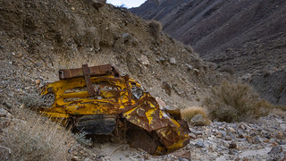
Though wilderness, the old road continues all the way up the canyon, crossing the wash - or the wash crossing it - a few times in the process. In one spot, the carcass of an old International R-110 - once owned by Lucky Rich - litters the rocky bottom.
The story goes that:
High up in nearby Paiute Canyon there is a gold mine called Baxter. The two brothers who owned it, both fighter pilots, died on a mission in the Korean War around 1951, and the mine was up for grabs. Two Saline Valley regulars became interested in it. One was Rogers, who operated the valley's talc mines. The other was his friend Lucky "Banjo" Baldwin, also known as Lucky Rich, who purportedly owned a lead claim in the Last Chance Range. Rather than splitting the Baxter Mine, the two friends simply gambled it: the first one to reach it from Willow Creek Camp would be the new owner. Lucky Rich tried his luck up this Canyon, but at a steep roadcut his truck overturned and crashed.
He was not the winner of the Baxter Mine.
Crumpled truck.Can't decide if "lucky" or "not so much."
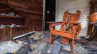
Beyond the wreck, the cabins of the ██████ Mill site nestled were into the canyon. Time hasn't been kind to these cabins, though it's clear that they were once well-kept and cared for, personal affects still strewn about.
The larger of the two cabins.Could stand to be oiled.Kitchen cabinet, for those things one must keep away from the mice.The bedroom - the back room of the larger cabin - still seemed somewhat serviceable in a pinch.A few hundred feet away, the second cabin - more recently used - looked inviting from a distance.Nicely situated, with views of the Saline Range.AOA - An Orange Adirondack.
With no mill to be found - making us wonder a bit about the naming of this place - we didn't poke around all that long before deciding to head back the way we'd come; we wanted to check out one more canyon before the sun dropped below the horizon and we turned into pumpkins for the night.
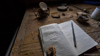
Always leave a note if you can. You never know who might enjoy reading it in the future.The highlight of this place really was the view.
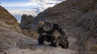
As I mentioned earlier, this canyon - unlike the others we'd visit - was generally quite wide. The exception to that description though was near its entrance where the walls closed in and the wash and road became one. The wash has won this battle over time, and a for a few hundred feet there are a several technical sections to navigate. Not that they caused any real trouble.
Down we go.Slickrock? In Death Valley? Apparently, yes.
With less than an hour till sundown, we headed south for a few miles before once again turning west - into an unnamed canyon - for our third climb of the day into the eastern Inyo Mountains. With limited light, the mouth of the narrows would be the perfect place to setup camp - the tall walls providing at least a little shelter from the wind.
Of course, even with only a few minutes to spare, I couldn't leave well enough alone. There were mines to explore up this canyon, and gosh darn it if we weren't going to try to visit at least one of them before dark.
While not wilderness, the road up this unnamed canyon has been thoroughly obfuscated by mother nature, and at the mouth of the narrows, we could make it no farther.Grasses in the wash were matted and covered in fresh mud. There'd been a lot of water in these parts just three months earlier as part of the 2022 DEVA Deluge.A few flowers poked up here and there, confused that it was nearly winter.
We had two mines to explore in this canyon, but only enough time to explore zero of them. As such, I suggested to @mrs.turbodb that we hoof it a little more than a mile to the further of the two mines, leaving the closer one for us to explore from camp the following morning.
As always, she was game, and soon we were racing up the wash, and then the road, and then the wash, and then the road. It was confusing.
If that pesky rain hadn't wrecked it for us, apparently we could have driven that final mile-and-a-half!
Our destination - the Lucky Boy Mine - was assessed until as recently as 1992, but it's clear that no one has really worked this area...ever. The road passes by a dusty dugout, the scattered timber of a collapsed cabin, and then two short tunnels that reach a few dozen feet into the hillside before the road peters out.
I'm always a sucker for dugouts.One of the two lower tunnels, its entrance protected from flooding of the wash by a rock wall.
Beyond this point, the four primary tunnels of the Lucky Boy mine are high on the hillside, a quarter of a mile up a nearby side canyon. Apparently, no one ever bothered to build a trail to them - the wash was the trail - and with the sun now below the horizon, @mrs.turbodb informed me that I was on my own if I wanted to climb the two dry falls that stood between us and the adits.
So enticing. If only they weren't another 700 feet higher than our current elevation!
Initially I decided that it probably wasn't the best idea to begin my climb through a trailless wash, but in the end, my hard-headedness prevailed - I'd brought a flashlight for goodness sakes - and I was on my way. The first fall - a knobby aggregate of Cambrian dolomite 25 feet high - required a bit of careful climbing, but soon I was scrambling up the tailings pile and wondering whether my real mistake was in not considering how I'd get down in the dark.
It was at this point that - from down below - @mrs.turbodb kindly yelled up to me that she was headed back to the truck. For the second time in a day - and in nearly the same position - she left me high and dry on the side of a mountain. Not that I can blame her.
An upper adit of the Lucky Boy mine - less interesting than I'd hoped from below.The real prize of my scramble was the view as the sky played games with color and light.
After a few minutes poking around, I carefully picked my way back down the dry falls and wash, figuring that I'd catch my companion as she retraced our path back to camp. Somehow though - even without a flashlight, and with increasing darkness - she kept ahead of me, and it wasn't until I peeked in the passenger window that we'd see each other again.
Though it was only 6:00pm, it was good and dark at this point. Even though it'd been - relatively - a short day of exploration, we were both tired and hungry given the travel and sleep situation of the last 48 hours, so @mrs.turbodb prepped dinner while I deployed the tent and proceeded to goof off with the head lamp.
Fully satisfied, we brushed our teeth and climbed into bed. Oh man, were we looking forward to some shut eye - but of course, mother nature had other plans...
Another fine adventure, thanks for the entertainment! Back in the day my friends and I would have taken risks (we did often) in the name of exploration but now I know better which makes me enjoy and appreciate your posts even more!
turbodbJanuary 9, 2023
Thanks John! Though I probably play them up a bit for the stories, I do try to be reasonably responsible in the risks I take. As I'm sure you know from those that you took, experience can help to mitigate some risk, but of course, they are never totally eliminated.
I reasonably recently (about a year ago now) picked up a Garmin inReach Mini because of my tendency to do “risky” things. Even so, I generally only opt to do the ones that I feel like are well within my abilities, and I try to coach others to make sure that what they do be within their abilities as well. An interesting one for me was a series of dry falls in another Death Valley Canyon, where I ended up ascending and descending several times in order to ensure that I was comfortable in my ability to downclimb when I was done exploring. If you’re curious, here’s a direct link to my guidance, and also the entire trip.
JOHN D MORANJanuary 9, 2023
YES, have to agree with you completely! Worst experience I ever had was descending a rock waterfall with a climbing buddy. It was like a chimney, we got to one small flat area, looked over the side to a sheer drop of a couple hundred feet (at least) and my buddy froze, refusing to go up or down just sitting there shaking for more than an hour. We had full climbing gear but he wouldn't budge. After reasoning with him all the time, telling him we'd just starve or freeze to death if we didn't move, I convinced him that I'd blaze a horizontal path, fix a rope, and we could get away from the falls and then climb back up. It was slow and we didn't get out until after dark. Fortunately we had the equipment but we didn't climb together again. We're still friends 60 years later and stay in touch but I don't mention that climb!
KennyJanuary 9, 2023
Another great adventure, finding old mines and homesteads are always a thrill, standing there trying to imagine how it was in the day when they were there. Tough folks that knew nothing but work.
I enjoyed the photos, the only thing is I think it is time for you to check out a drone, your wife could operate it even while driving then stop and get out and retrieve it. I have had three drones and had a blast with them and took aerial of places where likely no man has ever walked.
Keep on Truckin!
turbodbJanuary 9, 2023
Thanks Kenny! Imagining how much work it was for these guys is definitely part of the fun. They had some gumption; not many today would put in the effort they did!
I've been considering a drone - for stills - but in this case it wouldn't have done me any good as they are prohibited in Death Valley (all National Parks). Still - for a lot of places, I think one could get some very interesting perspectives that would be hard/impossible to get from the ground.
Ugh, more gear. ?
Oy boy, new toys! ?
JOHN D MORANJanuary 9, 2023
Yep, I've seen several others who explore mine, mountains, etc., and use some drone footage. Also a couple of off road recovery outfits that use drones and it really give one some perspective about the surrounding terrain which can be pretty amazing. Especially when a vehicle is on the edge of a cliff with a very long, sheer drop!
James ClevelandJanuary 9, 2023
Those workshops were very clean, besting my garage sometimes.
turbodbJanuary 9, 2023
Weren't they though? I'm sure there's been some relatively recent cleanup, and I bet relatively little visitation in order to get them to that point. Pretty nice surprise, really, given how destroyed so much of what we come across is these days!
PaulJanuary 9, 2023
Good one Dan...! Wondering if this trip will continue down that horrible washboard road to the South???
Cheers,
Paul
turbodbJanuary 9, 2023
LOL, you've got my number on this one Paul. Luckily, we weren't going all the way down that horrible road. One of the worst, really.
Bill RamboJanuary 9, 2023
You know, this country has places that might have never been photographed. Explored and lived in, yes. These views you provide us and the history coupled with the tales make this enjoyable reading. So with that, I got work to do on Taco in order to follow you one day. Dang, this is fun!!
turbodbJanuary 9, 2023
Thanks Bill, always nice to hear when you enjoy them! Hope the Taco is coming along nicely!
?
GusmoreJanuary 9, 2023
One is never too old for light painting!
Once again, GREAT photos - thanks.
turbodbJanuary 9, 2023
Thanks so much!
Richard SwanJanuary 10, 2023
Once again it has been a joy getting in to your story on these roads(Somewhat Roads !.LOL)....i Love the old Buildings and Mines and wish i could take my Taco there but she is not set up for that unfortunately.... I guess you should count your blessings that there is as many artifacts and such still left and not reclaimed by selfish individuals roaming those Hills....I guess we cant all be " leave it as you found it " types of people....Thanks for all your endeavors and as always,be safe...Peace !.....Rock on....C.R.Swan
turbodbJanuary 10, 2023
I am definitely lucky to be able to explore these places, and I often find myself "rushing" because I know that every year, more and more are found by those less respectful, or succumb to the rigors of time!
As for getting out in your Tacoma. 97% of what I do can be done with a stock Tacoma. Just sayin'. ?
Kurt KuntzmanJanuary 13, 2023
What a great read! As someone who grew up in So. Cal. The High Sierra and its surroundings always intrigued me with its beauty and history- you managed to capture both.
Thanks again for posting this, the only bad part is.....I can't follow your tracks and experience the same adventure you did.
Well done!
turbodbJanuary 16, 2023
Thanks Kurt, glad you enjoyed the story and photos. I spent a lot of time in the Sierra myself growing up, and California's mountains are certainly a special place on this earth. If you'd like to re-experience a bit more of some of them, you can check out any of the following, which highlight a few of the trips I've done up and down the various ranges. Start with the Inyo NF, as I think you'll really enjoy that one.
Lastly - if you'd like to follow along with future trips into these amazing places, you can always sign up for emails when I post new stories!
Jonny LawJanuary 15, 2023
How do you know it was the “ATVers” that torched that and not some tree hugging Toyota driver doing what you did and explore? Is that because you think only ATVers know how to operate a torch?
turbodbJanuary 15, 2023
I don't know for sure that it was ATVers, but it was just wide enough for an ATV to pass through, and not wide enough for any Toyota or Jeep.
Yeah, it's hit and miss with the weather in the winter. Sometimes it works out and sometimes it's better to just stay home. Technically, I think the roads are currently still closed due to the effects of Hurricane Hillary, but the NPS is working hard to re-open them, and as of right now, there hasn't been any snow that I'm aware of.
Winter is a great time to be in Saline (in general). Most (and perhaps all) of my trips there have been between November and March!
DUGeFreshNovember 2, 2025
I would like to offer an alternate theory, if I may, concerning the vandalized gate. I purpose it was done to accommodate a small 4 x 4, much like those found all over Santa Catalina Island. It's possible no ATVs were involved. :).


Another fine adventure, thanks for the entertainment! Back in the day my friends and I would have taken risks (we did often) in the name of exploration but now I know better which makes me enjoy and appreciate your posts even more!
Thanks John! Though I probably play them up a bit for the stories, I do try to be reasonably responsible in the risks I take. As I'm sure you know from those that you took, experience can help to mitigate some risk, but of course, they are never totally eliminated.
I reasonably recently (about a year ago now) picked up a Garmin inReach Mini because of my tendency to do “risky” things. Even so, I generally only opt to do the ones that I feel like are well within my abilities, and I try to coach others to make sure that what they do be within their abilities as well. An interesting one for me was a series of dry falls in another Death Valley Canyon, where I ended up ascending and descending several times in order to ensure that I was comfortable in my ability to downclimb when I was done exploring. If you’re curious, here’s a direct link to my guidance, and also the entire trip.
YES, have to agree with you completely! Worst experience I ever had was descending a rock waterfall with a climbing buddy. It was like a chimney, we got to one small flat area, looked over the side to a sheer drop of a couple hundred feet (at least) and my buddy froze, refusing to go up or down just sitting there shaking for more than an hour. We had full climbing gear but he wouldn't budge. After reasoning with him all the time, telling him we'd just starve or freeze to death if we didn't move, I convinced him that I'd blaze a horizontal path, fix a rope, and we could get away from the falls and then climb back up. It was slow and we didn't get out until after dark. Fortunately we had the equipment but we didn't climb together again. We're still friends 60 years later and stay in touch but I don't mention that climb!
Another great adventure, finding old mines and homesteads are always a thrill, standing there trying to imagine how it was in the day when they were there. Tough folks that knew nothing but work.
I enjoyed the photos, the only thing is I think it is time for you to check out a drone, your wife could operate it even while driving then stop and get out and retrieve it. I have had three drones and had a blast with them and took aerial of places where likely no man has ever walked.
Keep on Truckin!
Thanks Kenny! Imagining how much work it was for these guys is definitely part of the fun. They had some gumption; not many today would put in the effort they did!
I've been considering a drone - for stills - but in this case it wouldn't have done me any good as they are prohibited in Death Valley (all National Parks). Still - for a lot of places, I think one could get some very interesting perspectives that would be hard/impossible to get from the ground.
Ugh, more gear. ?
Oy boy, new toys! ?
Yep, I've seen several others who explore mine, mountains, etc., and use some drone footage. Also a couple of off road recovery outfits that use drones and it really give one some perspective about the surrounding terrain which can be pretty amazing. Especially when a vehicle is on the edge of a cliff with a very long, sheer drop!
Those workshops were very clean, besting my garage sometimes.
Weren't they though? I'm sure there's been some relatively recent cleanup, and I bet relatively little visitation in order to get them to that point. Pretty nice surprise, really, given how destroyed so much of what we come across is these days!
Good one Dan...! Wondering if this trip will continue down that horrible washboard road to the South???
Cheers,
Paul
LOL, you've got my number on this one Paul. Luckily, we weren't going all the way down that horrible road. One of the worst, really.
You know, this country has places that might have never been photographed. Explored and lived in, yes. These views you provide us and the history coupled with the tales make this enjoyable reading. So with that, I got work to do on Taco in order to follow you one day. Dang, this is fun!!
Thanks Bill, always nice to hear when you enjoy them! Hope the Taco is coming along nicely!
?
One is never too old for light painting!
Once again, GREAT photos - thanks.
Thanks so much!
Once again it has been a joy getting in to your story on these roads(Somewhat Roads !.LOL)....i Love the old Buildings and Mines and wish i could take my Taco there but she is not set up for that unfortunately.... I guess you should count your blessings that there is as many artifacts and such still left and not reclaimed by selfish individuals roaming those Hills....I guess we cant all be " leave it as you found it " types of people....Thanks for all your endeavors and as always,be safe...Peace !.....Rock on....C.R.Swan
I am definitely lucky to be able to explore these places, and I often find myself "rushing" because I know that every year, more and more are found by those less respectful, or succumb to the rigors of time!
As for getting out in your Tacoma. 97% of what I do can be done with a stock Tacoma. Just sayin'. ?
What a great read! As someone who grew up in So. Cal. The High Sierra and its surroundings always intrigued me with its beauty and history- you managed to capture both.
Thanks again for posting this, the only bad part is.....I can't follow your tracks and experience the same adventure you did.
Well done!
Thanks Kurt, glad you enjoyed the story and photos. I spent a lot of time in the Sierra myself growing up, and California's mountains are certainly a special place on this earth. If you'd like to re-experience a bit more of some of them, you can check out any of the following, which highlight a few of the trips I've done up and down the various ranges. Start with the Inyo NF, as I think you'll really enjoy that one.
Lastly - if you'd like to follow along with future trips into these amazing places, you can always sign up for emails when I post new stories!
How do you know it was the “ATVers” that torched that and not some tree hugging Toyota driver doing what you did and explore? Is that because you think only ATVers know how to operate a torch?
I don't know for sure that it was ATVers, but it was just wide enough for an ATV to pass through, and not wide enough for any Toyota or Jeep.
I see you were there in Dec, I was considering a winter trip to Saline Valley until I read this article....https://timenspace.net/2023/04/02/the-winter-that-was-2023/
Yeah, it's hit and miss with the weather in the winter. Sometimes it works out and sometimes it's better to just stay home. Technically, I think the roads are currently still closed due to the effects of Hurricane Hillary, but the NPS is working hard to re-open them, and as of right now, there hasn't been any snow that I'm aware of.
Winter is a great time to be in Saline (in general). Most (and perhaps all) of my trips there have been between November and March!
I would like to offer an alternate theory, if I may, concerning the vandalized gate. I purpose it was done to accommodate a small 4 x 4, much like those found all over Santa Catalina Island. It's possible no ATVs were involved. :).