
It was cold when we woke up the next morning, but who the hell cares when a breakfast like this is in the works? 

Let's take a minute to appreciate exactly what we're looking at here. That's a ½ lb of some of the best - only available in Montana - bacon, two Yukon Gold potatoes all diced up and cooked with onions, and a few eggs scrambled up in bacon grease. All on a plate in the shining sun with a mountainous backdrop to die for.
Yep, none of us cared about a little cold when we got up in the morning! It also meant that we cared little about lunch, given that we didn't roll out of camp until nearly 11:30am! 
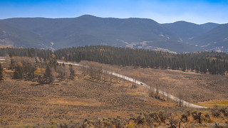
We did eventually get out of camp, continuing down the last bit of Tomichi Pass, dust the only indication that we'd been along the trail.


We passed the old Tomichi Cemetery on our way down, only two headstones still standing - though several other grave sites marked by simple crosses, the lives of the people buried here tough. Miners, likely, given death by explosion in the late 1800s.


From this point, we were quickly back in civilization - or at least the outskirts of it. Sparsely spaced cabins lined the road, their construction much more harmonious with nature than you'd find in a city or even town. The most striking was built around the trees that shaded it, their trunks stretching up - through its roof - to provide their shelter.
And through this section of woods, it was nice to see that the residents hadn't lost their sense of humor.

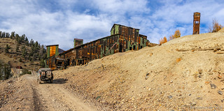
Transitioning from Tomichi Pass to Tomichi Creek, we continued following our route south, until we came upon the old site of the Akron Mine and Mill.

When placer gold was discovered in Tomichi Creek in 1878, and rich silver deposits subsequently discovered in 1881, miners from all over the country flooded to the area, establishing the towns of Whitepine and North Star. By 1884, the population reached more than 1,000, with several stores, saloons, and hotels setup to serve the locals. As was commonly the case, everything came to a screeching halt in 1893 when silver crashed with the camps deserted by the following year.
The Akron Mine was reactivated twice since its initial closing, the second time in 1938 to mine lead, zinc and copper for the war effort. It was during this period that a tunnel more than 1 mile long was dug to extract material, extending all the way to Lake Hill, Colorado.
Today, the area has been reclaimed by the Forest Service, many of the contaminated tailings sequestered in retention areas, covered with clean soil, and revegetated, and only portions of the mill foundation remain visible. (local information sign)
It was our first mine of the day - and quite honestly one of the least interesting, though we didn't know that as we picked up speed on the dusty roads - a Uranium mine our next destination.


Near Sargents - where I was surprised to see fuel - we headed east towards the Pitch Uranium Mine. Fun fact: Colorado has the third largest uranium reserves of any US state, behind Wyoming and New Mexico.
On the way to the mine, Mike suddenly came over the CB to let us know that he thought he'd hit something and he was pulling over to check things out. Turns out he didn't hit anything, but this was the second time he'd heard an extremely loud thunk while driving along. We all circled the wagons to check it out.

Our theory - based loosely on the transfer case issues I had over a year ago - is that Mike was experiencing something similar, and he was assigned homework to check it out on our return. For now, we continued on towards a mine that we could see was clearly active in the distance.

In fact, not much further up, the road was blocked off - the previously closed mine now abuzz with heavy equipment - whether they were mining or cleaning up, we could only speculate. To us, all that mattered was that we couldn't continue - and so back down the mountain we raced!
From the Uranium Mine - which, in hindsight may have been a good one to skip - our plan was to continue east to an area rife with old mines. We were headed to Bonanza.
On the map, this looked like a reasonably short trek - something easily done in an hour - and so, as we started up the next canyon, we didn't hesitate to stop for more colorful photos. Because - you know - the yellows here are obviously different than the last 50 stops! (to be fair to everyone else on the trip, if I'd been leading, we'd have stopped even more!)


Winding our way along Poncha Creek, we eventually popped out into the open and stopped to fill Ollie's water jug in the stream. A nice grassy area, we soon found ourselves comparing trucks - a common past time - this time, competing for "who has the least lift." An unpredictable or even surprising competition perhaps, given the crowd, but even in my short time I've found that the added down-travel of a lower lift is much more functional than pumping the coilovers all the way up, "for looks."


From our stop along Poncha Creek, we headed over the water and onto an old section of the Otto Mears Toll Road, which would take us up and over the final pass that stood between us and a mining mecca.


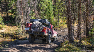
Much of the Otto Mears Toll Road would later become the Million Dollar Highway (US Route 550), but this section to Bonanza remains a Jeep trail through rough terrain - and with beautiful views. We enjoyed it thoroughly, our narrow 1st gen Tacomas, the perfect vehicles for the job.


The road - it turned out - took us much longer to traverse than I think any of us thought, and it was nearly 4:00pm when we found ourselves sitting above what can only be described as a mud pit, a tall enough ledge dropping down into the muck that we thought twice before proceeding.
Mike - perhaps only slightly over-confident in the Redheads ability - went first. He chose a line that appeared not-quite-so-tall as the main line, and proceeded to drop down, completely burying his front bumper in the sticky goo, before removing a bit of paint from the rear bumper as it scraped down the ledge.

Monte and I followed - taking a bypass - Monte because he had no rear armor; me because - according to my buddies - I'm a total wuss. And then it was Dan's turn. With 35" tires, he opted for the main - most difficult - line. He had no idea how deep that puddle was in front of his truck, but hey, what's the worst that could happen, amiright?

Like Mike, much of his bumper was ultimately submerged, and if Mike had scraped a bit of paint off his rear bumper, Dan used his to support the entire weight of the truck. But hey,  !
!


And with that, we'd essentially arrived at the mining district that we'd been driving all day to see - and at the site of the old Rawley 12 mine, the largest mine in the Bonanza Mining District. Now reclaimed, there wasn't much of this mine left to see, but we wandered around a bit, checking out some old parts and ruins before continuing on.


At this point, we couldn't help but to get a little inefficient with our use of the maze-like road system that wound around hillsides from mine to mine. We crossed our own path several times as we made our way through this maze, eager to discover what was left at each site - and even between sites, the area so covered with mining ruins.
The Bonanza Mill turned out to be one of the largest structures we'd see, and we spent a good amount of time exploring it and the surrounding area, its headframe rising up into the sky above the mill.


Like many of the mines in the area, silver ore was the "Bonanza" for which this mine was named. The name turned out to be overly optimistic - as was often the case, but the name stuck and 40,000 people passed through the area between 1880-81, including former president and Civil War general Ulysses S. Grant. (Colorado tourism)


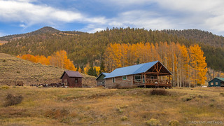
From the Bonanza Mill, we worked our way east - to the Alder Mill and mine. Situated high on a hillside, this would have been the mine I wanted to work at - the view over the valley, a tremendous benefit to what must have been hard labor. Here, old assayer buildings, what appeared to be locker rooms, and perhaps a lunch hall still stood behind the mill - still reasonably preserved after all these years.


Across the valley we could see our next stop - the Superior Mine - and we headed that way, excited by the name. Names however can be deceiving, and there wasn't much left of the Superior to explore - a tailings pile (parking area) and lone log building ruin, all that remained.


And here, we had a decision to make. The most direct route to our exit from this mining territory was down a set of steep switchbacks. On the map, they looked tight enough that we were unsure if they were even suitable for our trucks, or if they were only for ATVs and motorcycles. But, with the alternate routes adding several miles to our journey, we decided to give them a try - because the worst that could happen would be several trucks plunging to their deaths.

Our worry was for naught - the road and switchbacks easy to navigate - and to our surprise we discovered another mine about halfway down the mountain - perhaps the reason for the switchbacks in the first place!


And with that, our exploration of the area was complete. It was already 6:00pm, and not only did we have no idea where we were going to camp, but we'd planned on being another 30 miles or so along our route by the time we stopped for the night. As such, as we rolled slowly through the historic town of Bonanza, we were reevaluating our position on the map, and looking for some public land that we could call home.

Not too much further, we started up Ute Pass road - the trail we'd be taking the following morning - and found a spur road that appeared to lead through a valley and to a promising area for camp.

Sure enough, we found a reasonably flat spot, and the 8,500 foot elevation was a welcome change to the 11,000+ foot locations we'd found ourselves at previously. Having skipped lunch, we were all quick to get dinners made as we circled up around the fire and enjoyed the colors playing across the sky, the pink highlighting the odd-aspen in an otherwise evergreen forest.

We hadn't made it quite as far as we'd planned, but that's all part of the adventure. To get back on track - we wanted to spend the next several days on the Alpine Loop - we decided that we'd our earliest start of the trip: each of us waking at whatever time necessary to be driving out of camp by 8:00am!
It would be early, but in hindsight, the term "worth it," would be underrated...


