
Thankfully, the wind tunnel that can occur through the Lost Lake valley didn't materialize overnight, and we slept reasonably well, with the entire place to ourselves. I was up - as usual - just before sunrise, and the light was fantastic.
Unfortunately, I'd forgotten that I'd changed the settings on the camera to capture the Milky Way the previous evening - plus I failed to notice anything in the little viewfinder on the back as I reviewed them in the moment - and so I ended up with some very soft, very noisy shots that I've done my best to recover in processing.

This shot is why the morning camp photos are a bit meh. I guess I shouldn't complain too much. 
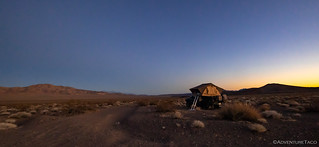
Soft morning light.
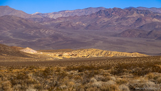
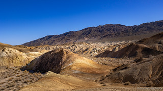
A desert view.
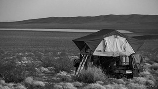
As the sun peeked over the horizon, @mrs.turbodb climbed down out of the tent and got to work on breakfast. We'd gotten some blueberries for our cereal, and they turned out to be fantastic, which was a great way to start the day.

As breakfast was prepped, I was wandering around and found this amazingly large casing. What is it?
Update: I've been informed that it is a 20mm cannon. It's used by many aircraft, here are the details on the F-18.
Breakfast was eaten and camp was stowed by 8:00am, as we set off to cover the four miles to our next destination. It was a perilously daunting journey , and ten reasonably-smooth minutes later - the engine hardly warmed up - we were at the trailhead.
Owlshead Mountains Road is the only vehicle-friendly trail in the area, and we had a nice view of our afternoon hike as we made our way west.

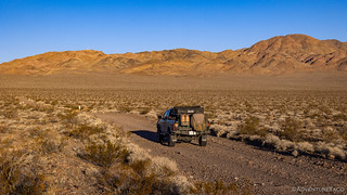
Parked at the trailhead to Crystal Hills.
It's always nice to be the only vehicle at a trailhead, but this was even better - our tracks were the only ones on the road - no one else had been here in quite some time! We slathered on some sunscreen, I setup the solar panels, and for the second time in 12 hours, we set out across the desert.

We'd be the first foot traffic in some time. And I think the burros might take offense at being called horses. Just sayin'.
Lost in the most far-flung corner of Death Valley, the Crystal Hills are the home of colorful badlands bursting with crystallized, minerals. In the 1920s an ambitious Angelino built a 30-mile monorail to transport the Epsom salts they contained all the way to Searles Valley. Remnants of his grandiose engineering achievement are still out there, as are the diggings of the Epsom salts mine, the rough dugout of Crystal Camp, and of course the timeless hills, sparkling with thousands of points of light.Hiking Death Valley
As the trail descends out of the Owlshead Mountains, we get our first view across the alluvial fan of the sparkling badlands.
So remote is this hike, that it's impossible to walk a straight line from the trailhead to Crystal Hills. Rather, in walking toward the hills, we came to the border between Death Valley National Park and the Naval Air Weapons Station China Lake (commonly called the NWC). Here, we'd have to skirt north - for nearly a mile - before turning west again, lest we subject ourselves to the hazard of unexploded ordinances.
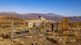
At NWC Davis gate, the shortcut to the Crystal Hills was obvious.
Relax Internet, I'm just egging you on with this photo.

An unexplained marker we discovered after circumventing the NWC.

Getting close now; the hills were quite striking.
And then, we arrived. There isn't a lot left from the Epsom salt mine at Crystal Hills, but an old - collapsed - wooden cabin, a disintegrating rock dugout, and some scattered machinery were fun to explore before setting off in search of the main attraction.

The old cabin - both the wood framing and rock foundation, collapsed.
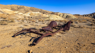
I found myself wondering... how does just a frame end up in the desert?
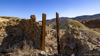
The rock dugout was in better condition than the cabin, but had certainly seen better days.

Colorful china to go with the equally colorful surroundings.

The salty ground is tough on anything metal.

Epsom salt crystals.
The main attraction - and the reason I'd drug @mrs.turbodb all this way - was the remnants of an old monorail. Constructed in the 1920's by Thomas Wright, the 30-mile-long monorail is perhaps one of the most astounding mining structures in Death Valley's history. Interestingly, it was not built to convey precious metal, but to transport ordinary Epsom salts to the Trona Railroad!
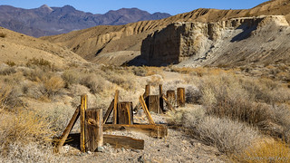
A short section of five A-frames that supported the monorail.
Why Wright didn't take a more traditional approach - using an existing road that already ran within a few miles of Crystal Hills - is explained by his motivations behind the entire endeavor: he was looking for fame. With no ability to go #viral on #metagram, he formed the American Magnesium Company and sold company stock to finance his glorious plan. His design, while influenced by existing lines, was unique - in addition to the center steel rail, the engine and cars would also balance on two lower, wooden rails, adding stability to the entire system. Construction took two years and $200,000.
The result was mixed. The tracks were often damaged by the harsh desert conditions and required constant maintenance. Propulsion was an issue as well - the trade-off between power and weight a constant issue for the rail structure. And then of course, there was braking - the long, steep, downhill segments adding a perilous risk to every load of ore. But when the monorail worked, it did so surprisingly well - innovative enough that it was featured in several scientific magazines. One valiant driver made the trip with a full load in just one hour, a feat that earned it the title of "fastest moving monorail in the world."
...Until 5 years later, when - in 1927 - the supply of easily accessible Epsom salts was exhausted. 

A half mile below Crystal Camp, a longer segment of frames - a few still supporting a top rail - exists just inside the NWC gate.
I must say, I very much enjoyed seeing the old monorail - its uniqueness amongst all the things we've explored over the years, a delight - before we turned around started back toward the trailhead. Along the way, we detoured through the colorful badlands behind Crystal Camp - experiencing the sparkling, colorful hills that were once worked with common garden tools to collect the salts sitting on the surface.

Nest with sunstar.

A century after the area was mined, the desert salts are making themselves known once again.

What in the world are these? They look like rocket bases, but must be some sort of transport container.

Colorful badlands.
Desert wrinkles.

Tortoise den? Burrow? Hole?
We arrived back at the Tacoma just after noon - 12:17pm to be exact. @mrs.turbodb had smartly prepped our sandwiches at the same time she'd made breakfast, and so with minimal effort we were seated in the shade of the truck, enjoying lunch in our rockers and looking up the road towards our next afternoon hike - the highest point in the Owlshead Mountains, Owl Peak.
Before we get there though, a few questions are worth considering:
- Are you a serial under-achiever?
- Does the thought of hiking Telescope Peak - Death Valley's highest summit - make you snuggle deeper into the couch?
- Is even getting second place just a little too much effort?
If so, Owl Peak might be right up your alley - because while it's the highest peak in the Owlsheads, it's the lowest peak in the park. And for us, that was perfect.  Lunch over, we climbed into the Tacoma and covered the two miles between trailheads, quickly.

The jumping off point to Owl Peak (center) was not much further up the road, near the old AT&T relay at the end of Owlshead Mountains Road.

Keeping the cab cool and the batteries fully charged, even as the fridge works furiously in the desert heat.
Of course, I jest slightly about Owl Peak being the lowest in the park, but this hike would be nothing like our morning stroll across an alluvial fan. While only half the distance - at 4.5 miles - we'd be going completely cross-country, gaining some 1250 vertical feet, as we reached the 4,666 foot summit. As the most remote peak in the park, its remoteness meant that care was in order.

Setting off along the ridge, a false peak standing between us and the summit.
The views - along nearly the entire trail - were stunning. Far from everything this place commands expansive views of public and government territory that most of us never get to see - Robbers Mountain, Eagle Crags, and Fort Irwin's Granite and Tiefort mountains.
To our west we could see many miles along the road we'd hiked to Crystal Hills. Making its way across Long Valley, the darker track of the Epsom salts monorail parallels much of its route to Wingate Pass and the southern end of Panamint Valley.

The road out of Crystal Hills (the badlands to the left).

How cool would it be to see the miles of monorail frame, now out of reach on the NWC?

In the distance, planes, trucks, and simulated structures dotted the land - targets for the pilots that own these skies.
To the east, the Owlshead mountains - and then a procession of parallel ranges - parade across the Mojave desert, one behind the other, all the way into Nevada.

Colorful ridges.

Gentle slopes.

Lost Lake hiding - for now - in the valley below.
We stopped frequently along the route - both to catch our breath as we ascended rises in the ridge, or simply as the views presented themselves to us along the way. A breeze picked up as well, helping to keep us cool, even in the afternoon sun.

Our view east from the false summit.
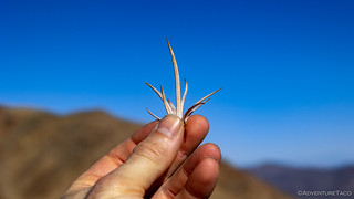
Some areas were littered with the spikes of barrel cacuts (Echinocactus polycephalus), where local burros pull them off in order to eat the juicy flesh underneath.

Making the final push toward the summit.
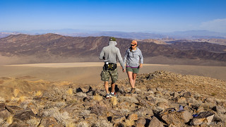
We reached the summit just before 2:00pm, our pace averaging just under 2mph. If the views on the ridge had been stunning, those from the summit were all the more special. Lost Lake - a destination that'd nearly bested us the previous evening - was visible in its entirety, as was the highest summit - Telescope Peak - to the north. We spent a good 45 minutes at the top, enjoying ourselves and building a 4-foot tall pile of rocks - twice, given our shoddy construction on the first attempt - on which to set the camera for a rare selfie.

There are not many who get to see this lost lake bed, and even fewer from this vantage point.
The rare selfie didn't work so well the first time.
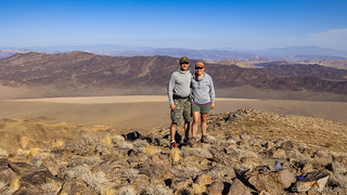
Better? Well, except that I look pregnant.
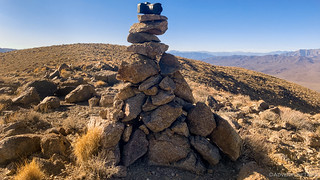
Our pile of rocks, redistributed after serving their purpose.
And then, it was back down the mountain - literally - to the Tacoma waiting below. Parked at a pull-out - below the radio tower under which we planned to camp - we wouldn't see it for the first hour of our return trek; by the time we did, we were glad to be nearly done for the day!

Salvation and relaxation!
It was quarter-to-five in the evening - about an hour before sunset - when we reached the perfectly flat surface of the carved-off platform for the old AT&T Long Lines relay station. We weren't sure exactly what it was until our return, but were happy to discover that it was out of service when we arrived, since that meant there wouldn't be any generators chugging away through the evening and night!
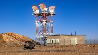
A quiet giant.
We found our perfect spot - right out on the edge of the platform - and quickly deployed camp. For the first time in many nights, we prepped - and cleaned up - dinner with daylight to spare. And we enjoyed the rainbow of hues playing across the landscape and sky from our own personal front-row seats.
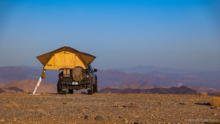
Living on the edge.

Long shadows, a long way from...everything.

The best show, with the largest screen.
Color still on the western horizon, we climbed into bed. We'd covered 15 miles on foot over the course of the day - three times the number we'd driven, and we were both ready for some quality time reading our Kindle Paperwhites before dozing off for the night.
I think I lasted about 3 minutes.

Looks like sunrise, but on the wrong horizon.
We didn't know it at the time, but the next day would bring decisions we've never had to make before, and I hope we never have to make again - as, with water running low, we split up and head separate directions across the desert.
The Whole Story


Love Death Valley? Check out
Death Valley Index
for all the amazing places I've been in and around this special place over the years.
The marker near the NWC looks a bit like a radar reflector?
Thanks Andrew - that certainly wouldn't surprise me - I'm sure they are using plenty of instrumentation all the time in that area. Is the idea, maybe, that the marker would somehow register on radar as a "known entity," allowing pilots to know that once they passed it, they were either on - or off - the NWC? Seems reasonable.
Ahh yes, the suspenseful ending...! Love it...!
--Paul
The wikipedia article has some photos of the original monorail including some information on the cars. https://en.wikipedia.org/wiki/Epsom_Salts_Monorail
Thanks Verlan, this is super interesting! It’s always nice to learn more about the history behind some of the places I’m able to visit. Thank you.