
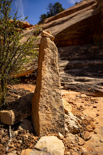
I was pooped when I climbed into the tent on the edge of the West Fork of Johns Canyon. A full day of hiking (I'd covered more than 16 miles), after only a few hours of sleep (about five), meant that I knocked out a full three minutes of reading before my eyes closed and my thumb stopped "turning pages" of Tom Clancy's Red Winter. Sleep was bliss.
I'm not sure I woke up at all before the soft charm of my alarm - a little diddy that everyone probably knows from YouTube survey ads that play before videos but that I like as an alarm - began playing somewhere under my comforter.

Knowing I had another full day ahead, I got the tent stowed - and a hearty breakfast of donettes consumed - before heading making my way back to UT-261 and my almost-close-enough-to-walk turn off onto Cigarette Springs Road. From there, it was a few well-graded miles to the first of three trailheads that would shuttle me along and through Road Canyon over the course of the next twelve hours.
Note: Visiting Road Canyon (and Cedar Mesa in general) requires a pass, even for day use/hiking. For more information, check out BLM Utah Cedar Mesa Permits and Passes Information.
Way One
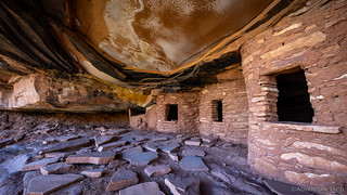
My primary destination on this first hike was simple: a single, well-known ruin where a several-inch thick layer of the sandstone alcove above the granaries has fallen. Aptly named, the Fallen Roof Ruin is one of the more photographed ruins on Cedar Mesa. With the sun already warming the cool air, I set off on foot.


When visiting rock art and ruin sites, be respectful.
This is most easily done by following the Leave No Trace principles; leaving the place exactly as you found it and taking with you only photographs and memories. In case that is not clear enough for some reason, here are examples of respectful behaviors:
Shortly after passing the giant hoodoo, I caught a glimpse of the Fallen Roof Ruins a couple hundred feet above the wash. Scrambling up the slickrock, I eventually found myself on a shelf near the canyon rim. A few minutes later, I'd arrived.


While the Fallen Roof Ruin is the most well-known in this area - and the reason I'd headed into the canyon at all - it turns out that there are several other sites worth visiting, if you can find them. With no directions it was a bit like hunting for Easter eggs, appropriate given the time of year.
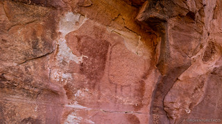
It wasn't long before I found my first (simple) pictograph. I'm still not sure what it represents, but something about it is intriguing to me, and I really like it.

I don't know if my confidence increased, or if I just happened to get lucky with where I looked, or what, but after finding that first pictograph, I soon found several others on a couple different benches above the wash.


Whew, after all that, I bet you're thinking, "Am I just going to see a hundred photos of different old ruins? These things all look the same."
And no, you won't see a hundred. It's going to be more than that. Stop complaining.
Anyway, it wasn't all ruins and rock art in Road Canyon, the local inhabitants were out to play as well!


(anyone know the name?)

After another mile or two, I reached what I gathered to be the end - in that the shelf I was traversing dropped precipitously to the bottom of the canyon - of the ruins, and pivoted 180° to begin my upward trek toward the rim. I was quicker in this direction, but only in the relative sense - the rock and sky around me, begging for attention.


Still, even with all my ogling, I was back to the trailhead - and Tacoma - just after 10:00am. For once, I was way ahead of schedule.
Unacceptable.
Way Two
Riding high on my failure, I wasted only a little time - snacking on donettes - before trying to extend my streak with another foray into Road Canyon. My access this time would be from a different location as I searched for a group of Seven Kivas nestled into an alcove just above the wash.
Unlike my first descent of the day, the route for my second would send me down a steep talus slope on my way to the bottom of the canyon. While this didn't dissuade me in the slightest, I'm sure the terrain - as well as the difficulty of locating the trailhead - reduces the number of folks who visit this site, which was just fine by me!


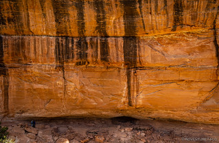
Perhaps most surprising to me as I reached the wash in the bottom of the canyon, was the sheer amount of water that was coursing over the sandstone. While it wasn't - with a few exceptions - "flowing," there was a lot more than I'm used to, and a real indication of the wet winter that the area experienced this year.


I knew I had a couple of miles to cover before I'd reach the kivas, but with a good trail to follow and the red rock of Cedar Mesa to keep me occupied, it seemed like only a matter of minutes before I spotted the bend in the canyon that was my ultimate destination. To my surprise, two other hikers - the first other people I'd seen in two days - were standing just below the alcove.


(Note: I would get a better view later in the day; it was accessible, but there were no ruins.)
Not wanting to disturb them, and hoping they were on their way "out," we exchanged quick greetings and I headed towards the opposite side of the canyon where I hoped to find a route that would take me to a bench a couple hundred feet above the wash where I could get a nice view of the entire site.
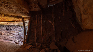
While none of the Seven Kivas are very large, it was a real treat to see so many in such close proximity. Additionally, three of them still had roofs that were mostly intact!

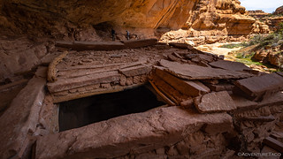

Poking around for twenty minutes or so, I was careful to avoid touching any of the ruins or enter any of the interior rooms - an important rule to follow in order to preserve these structures for as long as possible - as I looked for more evidence of those who once called this place their own.


By 1:00pm, my second exploration of Road Canyon was complete, and I was on my way back to the Tacoma. It was lunch time, and I was looking forward to a turkey sandwich with In-N-Out peppers to offset the ultra-healthy combination of donettes and trail mix that sustained me for the first half of the day.
Oh, and I'd somehow managed to increase my lead on my schedule enough that I even considered a nap - though in the end I just relaxed with my book for a couple hours before going stir-crazy - before my final foray into Road Cayon.
Way Three
I'd originally planned to undertake my third hike of the day just before sunset, making my way back under the cover of twilight. While this may sound crazy, there was a method to my madness - first, I was hoping for some nice light on what I knew to be westerly-facing ruins. Second, I knew that my destination was a popular one, and I hoped that by going later in the day, I would avoid - by the number of cars at the trailhead - a rather crowded situation.

The biggest problem with my plan - however unlikely - was my unusual position of being both ahead of schedule and unable to sit still. Combined with a bank of high clouds that were blowing in from the west - and looked as though they'd prevent any color from the setting sun - I set off along the rim just before 4:30pm, unconvincingly convincing myself that it would be nicer to cook dinner and clean up with some remaining daylight anyway.

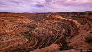
Whereas my first two Road Canyon hikes had me descend - and then eventually climb - the 500-foot height differential between the rim and wash, this final hike of the day would keep me on a (more) level path as I made my way east - a fact that my feet and legs certainly appreciated.


Known as The Citadel, the most striking feature of the ruin to which I was headed - at least in my opinion - was not the ruin itself, but the final approach to get there. Chosen - as so many cliff dwellings were - for its defensibility, the ruins were nestled into an alcove at the very tip of a long land bridge. I caught my breath as it initially came into view, and then proceeded to take what would have amounted to several rolls of film as I picked my way down the extremely exposed slickrock towards the near end.


Crossing the bridge and climbing the last bit of sandstone on the island, I was rounding the last large stone when I ran into Denny. A representative of the Friends of Cedar Mesa, I'd noticed him when he'd pulled up in his 2nd gen Tacoma before heading out on the trail, and apparently, he'd noticed me as well, procrastinating my own departure!
Turns out that he was there to help educate folks about archaeological etiquette, and as it was apparent that no education was necessary in my case, we spent a good twenty minutes talking about various hikes in the area as well as the amazing amounts of water that seemed to be everywhere this year.
While Denny was the only other person I saw the entire time, he also mentioned that he'd talked to more than three-dozen people in the last several hours. I didn't say anything, but I took this as an indication that while I may not have had the patience to wait until sunset, I'd definitely could have done a lot worse!
Eventually we parted ways and I rounded the final stone.


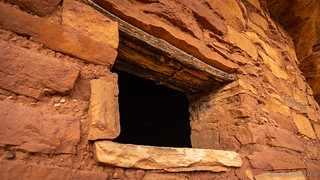

The great thing about the "island" on which The Citadel stands is that the entire circumference is accessible on the main bench. Sure, there are some steep, several-hundred foot drops to the canyon below, but that just adds a little excitement to the circumnavigation and the enjoyment of the additional granaries found along the way.
Literally at the end of the road, there was nowhere to go but the way I'd come - perhaps a drawback to the fortification should it have been attacked. Of course, there was no such threat today, as I leisurely headed toward camp and Tacoma.
Finding a nice, secluded spot at the trailhead, I prepped dinner, backed up a few photos from my camera to computer, and settled down with my Kindle as a light breeze blew through the screen door of the tent. Even having covered more than 15 miles of trail, it'd been one of most enjoyable, relaxing days I'd had in a long time.
With one more day of exploration planned, I realized - just as I was nodding off to sleep - that I may have made a rather large mistake in my planning...


Wallflower ✓
And the cactus goes by the name "Prickly Pete" to his friends but I'm sorry I don't know his real name ?
LOL, I didn't recognize Pete without a full head of flowers. ? Glad you enjoyed the story, and I hope you've had a chance to enjoy a few other trips as well. ?
Interesting how cultures of bygone days lived and prospered. These folks were very resourceful and mindful of their land. Reminds me of the latter days in the wilderness of how the first settlers lived in the Northwest deserts and the places they homesteaded.
All these folks knew was hard work and providing for their families and community. How did they get by without a TV or a cell phone or the internet? ha ha Getting out in the wilderness gives us the opportunity to experience how these folks lived, and then we get to come back into our reality of the modern world.
Excellent story and photos Dan, we all appreciate you sharing your ventures.
As usual, looked like an excellent trip. That cactus you wanted to know the name of looked a lot to me like Echinocereus fendleri var. rectispinus, Fendler Needle-spine Hedgehog but hard to tell for sure. I couldn't tell how big it was from the photo.
Thanks! (the trip is only half over, as well!)
And thanks on the cactus thoughts. Some sort of Hedgehog sounds right to me as well, and of course, I'm getting old enough now that I completely forget how big it was. I want to say the height of the tallest stalk in the front was ... 4" or so? (plus the height of the spines on top)
By the way, that yellow flower looks like Sanddune Wallflower, Erysimum capitatum. UJ
Nice, thanks! (I almost, sort of, was able to ID it, hahaha!)
Looking into that cactus I think it might be Kingcup Cacus, Echinocereus triglochidiatus. UJ
I wish I'd gotten a bit better angle of the top. The photos I found online of a Kingcup (which I assume is/is related to a Claret Cup), all seem to have a cluster of new spines on the top that make a little "button" of spines. I don't see that in this photo, but it could entirely be due to the angle I shot it at.
Yes, it could easily not be "Kingcup". Also, it could be the time of year (the part of the growing season that it is in) that could relate to the spines on top. UJ