With much of our summer taken up with a kitchen remodel - perhaps a non-adventure story that I'll share some details of once we've completed it - and the Tacoma in Washington after we abandoned our non-refundable plane tickets after running the Utah Backcountry Discovery Route (UTBDR) in July, we were looking for somewhere a little closer to home as we started feel the antsy urge to escape to the outdoors.
Not having had the time to plan a route - a process I enjoy, but that can consume nearly as much time as a trip itself - it dawned on me that I could leverage the work of the good folks over at Overland Trail Guides to at least find a nice area to explore.
I've chatted with Ben (who runs the site) many times in the past as he and I have shared tips, locations, and ideas about great places to explore, so I sent a quick email to inquire about a trip through the Siskiyous that I'd noticed on his site. Located along the Oregon-California border, it looked like it could be the perfect getaway for us. The only catch - the Flat Fire was burning nearby, so we'd have to be stay alert to evacuations, and keep our fingers crossed that we wouldn't be smoked out.
Route in hand, we headed south towards a wild land, nestled between the Cascades of the Pacific Northwest and the Sierra of California.
As we passed through Tacoma, a blacked out Chinook thumped by overhead.Just south of Portland, a mileage milestone.
I think it was a half hour north of Grants Pass that clear blue skies began to turn hazy. We knew this was a possibility, but hoped that the 90 minutes or so to Ashland would take us through the worst of the smoke and that northly winds would push the smoke away, just for another few days.
Luckily, the smoke mostly seemed to be above us, and after a quick stop in Medford for taco truck dinner, we arrived in Ashland as the sun was listing towards the horizon. Deciding that it'd be better to start the trail in the morning with the sun at our backs, we noticed a nice little chunk of (Bureau of Land Management) BLM land to our east, and soon found a little spot near the Pacific Crest Trail to call home for the evening.
I'm never a fan of locked logging gates on public land, but at least we wouldn't have to worry about traffic on this little spur.
The following morning...
Even having gone to bed at an extremely reasonable hour, we'd forgotten to bring pillows and so didn't sleep all that well, resulting in our getting up a little later than usual, right around 7:30am. A quick stop for fuel and an anything-but-quick-stop for a road work flagger, and by 9:00am we were off pavement and officially underway on the Siskiyou Crest Adventure Trail!
One of the cooler National Forest entrance signs we've seen.Onto dirt and into our first tree tunnel.
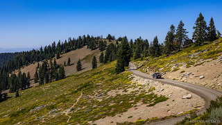
I have to say, the first several miles of trail had me worried. One of the reasons I seem to gravitate towards the southwest in many of my travels is that here, in the Pacific Northwest, it is so easy to be in a totally spectacular place but not be able to see it due to all the trees! I don't know if @mrs.turbodb was feeling the same way, but I surely wasn't going to bring it up this early in the trip. And, luckily, my fears were alleviated a half hour later as we gained elevation and the road began to open up to the vast beauty around us.
I always love the peeling bark of the madrone trees. Along with manzanita, this is what I think of when I think of "going to the mountains."We got our first peek at the peak as we came around the bend.Definitely hope we can check out the radome on Mt. Ashland a bit more closely!
It took another half hour or so of windy roads and anticipation to reach the top of Mt. Ashland. Part of a ski resort that I didn't even know existed, I can imagine riding up the chair lift just for the 360° view that presented itself when we got to the top. The perfect place for breakfast, my copilot set about pouring cereal while I wandered around snapping a few photos.
I made sure to strategically position us for the optimal breakfast view of Mt. Shasta to the south.Looking down from the top of the Ariel lift, Mt. McLoughlin rising up over the smoke.
We'd picked up some generic Kroger brand Honey N' Oats with Almonds cereal and I have to say, I actually liked it better than the real stuff we'd forgotten at home. Strangely, the traits that usually make generics less appealing - like a more rustic grind to the corn flakes, and a thicker cut on the almonds - worked well in this case, a nice surprise as we munched away on the top of Mt. Ashland.
Soon though, we were both downing the last drops of milk in our bowls and excited to hike a few hundred feet to the top of the mountain. There, the radome glistened in the sun, and we were sure the views would be even more magnificent.
Radome sunstar.Never seen a survey marker that is a "horizontal control mark."More than a little smoky between us and Mt. Shasta.
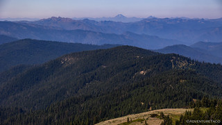
Knowing that we had nearly 350 miles to travel in the next three days, and keen to get a few more of those in our rear-view mirror, we headed back to the Tacoma and were soon descending the glorious road that'd delivered us to our first fantastic view of the day. Below us to the southwest, the smoky, mountainous terrain sprawled into infinity; around us, the day-to-day splendor of nature flourished.
Off we go...We didn't make it far before stopping to admire a few flying friends.And flittering ladies. (Painted Lady - Vanessa cardui)And floating fuzz. (Yellow goatsbeard)
For the next day - and then some - we'd find ourselves winding along next to the Pacific Crest Trail. Running into adventurers much more adventurous than we were, their trek between Mexico and Canada was some 2,653 miles long, many of them passing each other here in the Siskiyous, approximately halfway along the route.
I love hiking, but as we rolled along the ridge above the PCT, I was glad to have a gas pedal.Even I love a good tree tunnel when it's part of a varied terrain.
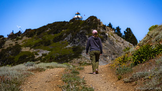
Of course, while we'd be making faster progress than those on foot, we definitely weren't setting any records for how quickly we were ticking away the inches along this section of the route. Easily distracted, we soon found ourselves out of the truck again, and on our way to the Dutchman Peak Lookout.
A sign on the gate informed us that lookout hours of operation were "9-5 when the flag is flying." Never forget to turn around when you're hiking or driving. You might miss the view over Silver Fork Basin.
Dutchman Peak is the last of the Oregon's original cupola lookouts that is still in use. Built in 1927 it is one of the oldest lookouts remaining in service in the United States. Originally called the Lost Dutchman, it got its name after a German named Hensley - mining at the mouth of Wards Fork nearby - took his pack horse to a trading post near Hilt, California for winter supplies just before Christmas. After picking up some grub and a gallon of whiskey, a storm passed through as he was on his way home and he never returned to camp. The next spring his horse was found grazing near Squaw Lakes and eventually his body was found on the west side of Dutchman's Peak.Historical Note in Lookout
A predictably commanding view.
Though the flag was flying, we arrived to an empty cupola, perhaps the lookout off to the local trading post for the week's supplies. Hopefully with more success than Hensley of course. At any rate, we let ourselves in and had a look around at the rather sparsely furnished lower room, before signing the guest book and getting on our way.
Strange to leave the flag flying when the lookout is clearly unmanned.Great views and clean.⭐⭐⭐⭐⭐, would use again.As we headed back down, we got our first - that we noticed - view of a distant Preston Peak, still with a teeny bit of snow.
Now headed south, we continued to cross over the Pacific Crest Trail as we made our way into California. We were on a spur off of the main route, headed south to Dry Lake Lookout, billed by Oregon Byways - a book that @mrs.turbodb had brought along - as "worth a visit."
Here, today, to us, borders held little import. Rather, we were searching for a good place - in the shade - to have lunch and satisfy our grumbling stomachs. To others however, borders were everything, and as the forest opened up - on a meadow that contained a cabin we hoped to eat at - we stumbled upon some of those "others," already relaxing on the front porch.
I don't know if every PCT marker was either shot up or stolen, but we didn't see any that were in good shape.When you run out of budget, but still have an I-beam.Our planned lunch spot, occupied!
Built in 1935 as a line cabin for ranchers running cattle in the mountains, the Donomore Cabin wasn't always a nice stop for PCT hikers. In fact, until about a decade ago, it was slowly falling into disrepair, the tough winter snows taking their toll on the place. However, beginning in 2015, a couple of families who once lived on the land began to stabilize and repair the old structure, which is now a welcome sight for those pushing their way through the Siskiyous on their long journey through the mountains.
Inside, the current residents - one headed north, the other south - had the place feeling downright homey.Apparently, everyone needs a trailname.
After chatting with the hikers for a bit, we excused ourselves in order to continue our search for a shady spot with a view - a tall order when the providers of shade are also generally anti-view-devices. For another hour, nothing great really presented itself, so we continued on with a few snacks, eventually finding ourselves at the former site of the Dry Lake Lookout.
Despite the name, Dry Lake Lookout was - had it still been there - on the top of a mountain.
Constructed in 1925, the lookout replaced a small 'shack' that was used previously. The structure - eventually removed in 1971 - was a California Region 5 Plan 4AR cabin with a 6-foot enclosed timber tower.USFS - Siskiyou County Museum Collection
Thankfully, as we headed back toward the Oregon border and the main Siskiyou Crest Trail, the sun had pivoted far enough in the sky to provide a bit of shade along the edge of an old logging platform. Waking my companion from her "after-breakfast" nap, I grabbed the Cheetos and set up the chairs while she assembled the turkey sandwiches that we hoped would be as great as those we'd had on the Utah BDR nearly a month earlier.
Time for lunch!
It was a quarter-to-three when we wrapped up lunch - a time that would come back to bite us when it came to eating dinner at a reasonable hour - and crossed back into Oregon. We'd remain in this state - though only a stone's throw from California - for the remainder of the day, winding our way along ridgelines and slaloming along streams, as we worked our way west.
These Christmas Trees have really gotten out of hand.@mrs.turbodb is the one who spotted the lookout first.Window shutters are open, hope we can go up!No dice.
With the road closed a little more than a mile - and 2,000 vertical feet below - the Acorn Woman Peak Lookout, there was no way we were going to make the trek up there. Though we were a bit bummed given the open shutters, we later discovered that this is a lookout that is rented by the USFS, so the occupants probably wouldn't have been happy to see us anyway.
Looking out over the Siskiyous, and Acorn Woman Lakes.
Working our way off the ridge, we soon found ourselves along the Applegate River, some 2,000 feet lower than we'd spent most of the day. It was hot. Definitely not an elevation we wanted to spend the night at, we turned up the air conditioning and enjoyed the meandering pavement as we worked our way past Applegate Lake and a swimming hole that nearly coaxed us into the water!
Happy tank.It's hard to see from this angle, but there's a "jump" at the end of the spillway. Would be cool to see water hurling down that ramp!Applegate Lake looked like a great way to cool off.
It was nearly 5:00pm when we turned off the highway and began a 50-mile loop that would eventually deliver us back to nearly this same point the following morning. Of course, @mrs.turbodb - paying closer attention to the maps than I do - knew that already, but I wouldn't realize it until she informed me of it nearly twelve hours later. Yep, I'm a quick one.
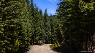
Regardless, for now we were gaining altitude - thank goodness! - on our way to the Whisky Ridge Jeep Trail, a trail that I hoped would provide a little bit of variety given the well-graded roads we'd traversed so far.
A break in the trees gave us our first glimpse of Whisky Peak.
Now, I should have realized by the name - "Jeep Trail" - that what we were in for was more of the same graded gravel we'd seen all day. Still, the views were getting better and better as we reached the ridgeline - which could have been achieved in an actual Honda Ridgeline as easily as in any "Trail Rated" Jeep - and as we crested the ridge, @mrs.turbodb noticed that there was a hiking trail to an old lookout. Only about half a mile long and at our highest point on the ridge, it seemed like a great way to end the day, our plan to find a campsite nearby once we came back down.
From the trailhead, it was some 700 feet to Whisky Peak, and we gained altitude quickly.As we headed up the trail, we were high enough to get a little wildflower action. (Alpine aster - Aster alpinus)The Scarlet gilia (Ipomopsis aggregata) was looking nice as well.A break in the trees revealed a spectacular view of the Red Buttes.
Climbing mostly on the east side of the mountain - and therefore mostly in the shade - we made quick work of the hike and soon found ourselves at the top of a very narrow ledge. Perched there, a stone-and-concrete foundation with a few boards still strewn about was all that remained of the Whisky Peak Lookout.
Where has the lookout gone?
Originally built in 1922, the original small wood-framed cabin was replaced by a 14' x 14' gable-roof L-4 cab in 1930.
The original lookout building.Upgraded model.
During the early years of World War II, the Army Air Corps took over a number of U.S. Forest Service fire-lookout facilities on the Pacific Coast as part of its Aircraft Warning Service (AWS). This emergency program employed observers scan the western skies for enemy aircraft while a new technology - RAdio Detection And Ranging (radar) - could be perfected and strategically installed. Among those lookouts was the Siskiyou-Rogue River National Forest's 6,497-foot-high Whisky Peak.
Perched on the summit next to a near-vertical 600-foot drop to Low Gap Creek, the lookout became winter quarters for Bill Zeigler, and another AWS man. Their task at Whisky Peak, which was in a rugged and remote portion of southeastern Josephine County, was to report to the army by means of crank telephone any aircraft heard or observed. Forest Service crews on skis delivered food and other supplies to the pair every two weeks.
After several years of abandon, the lookout was salvaged for the new Sand Mountain Lookout near Sisters, Oregon in 1989.Oregon Encyclopedia
Not long after we reached the top, we headed back down to the Tacoma and found what I can only describe as our best camp site of the adventure. Perched at the top of a precipitous drop, we were mostly above the smoke and had a cool breeze blowing through camp.
Unfortunately, I can't say the same great things about dinner. So accustomed have we become to our flights to Las Vegas and provisioning in the grocery store there before heading out that I'd completely forgotten to bring salsa to make guacamole for our taco-rittoes. This fact in itself wouldn't have been all that terrible, except that the avocados I'd brought along were still hard as a rock, and completely inedible. Still, we would have been just fine had I remembered to put the Tapatio into the meat-bean-rice mixture that filled the bulk of our tortillas and provided a nice spicy flavor.
At least we had a nice view.
Our dinner disaster behind us, there was nothing to do but enjoy the long orange rays of the sun as it settled into the smoke soup covering the land as far as the eye could see.
When you have to be careful stepping out of the tent, you've found a good spot.Goodnight sun.
It'd been a long day. Though we were less than 40 miles from our starting point, we'd covered a little more than 135 miles of trail on the 310-mile route, easily keeping us on schedule for the remainder of our trip.
And so, climbing into the tent, our spirits were high. All we could hope was that the winds would keep the worst of the smoke to our west, and that none of our roads would be blocked by flames.
Thanks for giving a shout out to Overland Trail Guides. Ben Easley has done a great job with this site.
turbodbSeptember 14, 2023
Ben's a great dude. Haven't ever met him personally, but we've definitely hit it off in our written communications. Always so nice to find folks who share common interests and have good intentions as opposed to just being in it for the 'gram.
BenSeptember 14, 2023
Can't wait for the next one to come! Your photos certainly give me something to strive for! Hoping to pick up a Sony A7 IV in the not so distant future 🙂
turbodbSeptember 14, 2023
Thanks Ben! As far as the photos go, I stand by my assertion that If You Take Enough Photos, Some Are Bound to be Decent ?. That Sony will be sweet, I bet. I'm sort of kicking myself for getting a Canon R6 instead of an R5, but I'm hoping to remedy that when the R5 mk II is released, likely next year. I certainly don't need anything more than the R6, but as with so many things, needs and wants aren't always aligned!
Do enjoy the rest of the adventure, and as always, feel free to use whatever you'd like for your site.
Travis RutherfordSeptember 18, 2023
Taking pics of my MH-47 again huh?? 😉
As always, great write-up and pics bud. Keep 'em coming!


 And, luckily, my fears were alleviated a half hour later as we gained elevation and the road began to open up to the vast beauty around us.


Thanks for giving a shout out to Overland Trail Guides. Ben Easley has done a great job with this site.
Ben's a great dude. Haven't ever met him personally, but we've definitely hit it off in our written communications. Always so nice to find folks who share common interests and have good intentions as opposed to just being in it for the 'gram.
Can't wait for the next one to come! Your photos certainly give me something to strive for! Hoping to pick up a Sony A7 IV in the not so distant future 🙂
Thanks Ben! As far as the photos go, I stand by my assertion that If You Take Enough Photos, Some Are Bound to be Decent ?. That Sony will be sweet, I bet. I'm sort of kicking myself for getting a Canon R6 instead of an R5, but I'm hoping to remedy that when the R5 mk II is released, likely next year. I certainly don't need anything more than the R6, but as with so many things, needs and wants aren't always aligned!
Do enjoy the rest of the adventure, and as always, feel free to use whatever you'd like for your site.
Taking pics of my MH-47 again huh?? 😉
As always, great write-up and pics bud. Keep 'em coming!