
After completing the Utah Backcountry Discovery Route, we're up to seven BDRs since we started running them seven years ago in 2016. Through the running of each one, @mrs.turbodb and I are - as you can imagine - regularly comparing the current BDR to the past ones. I finally started writing some of these comparisons down, and - of course - I now feel obligated to carry on that tradition into the future.
TL;DR - The Utah BDR really is an iconic route. While it largely hugs the eastern side of the state, there is great variety in the terrain, perhaps more so than any other BDR we've run. Each stage - with the possible exception of the northernmost (Stage 6) - brings the opportunity for "firsts" on the route. There's one catch though - if, like us, you've explored much of southern Utah prior to running the UTBDR, you may find it a bit repetitive, as it visits many of the "mainline" attractions in that part of the state.
And so, let's get into the details!
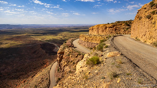
The Roads
The mix of roads for the UTBDR was nice. For those following the "main" routes for each stage (vs. taking the "expert alternates" when they are available), nothing along the route was difficult for a high clearance 4WD vehicle and at least the vast majority of it could have been done with 2WD. Full size vehicles and even those towing an off-road trailer should make easy work of the route.
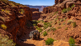
That said, the "expert alternates" - especially the alternate route through Lockhart Basin on Stage 2 - were some of the best segments of the BDR for me. Part of that was due to them being "new" to me, but part of it was due to the variety in terrain that such a route affords. While I wouldn't recommend running them as an unexperienced solo vehicle, I would highly recommend taking these alternate routes if you are in a group. Note: some of these alternate routes could be too narrow for a full-size vehicle, and I wouldn't recommend a trailer.
There was certainly pavement along the route - but I wouldn't say it was overwhelming. Something in the 10-15% range, usually at the beginning or end of a stage where the target audience (dual sport cyclists) would be looking for food and lodging.
The Scenery/Landscape
There's really no denying that Utah was the winning state in the landscape lottery. Right off the bat, the experience of driving through the Valley of Gods is spectacular, the bright orange buttes towering over the landscape. From there, the climb into the La Sal Mountains - through dense forest and over a 10,000-foot pass - is such a dramatic change that you'd be forgiven if you thought you were in a different state entirely. These changes continue - through the Book Cliffs, Uinta Plateau and Mountains - with ample opportunity for short detours along the way, where rock art, Native American ruins, and grand vistas are waiting to be discovered, just off the main route.


The best time of year to do this trip? In my opinion there are two:
- I think the absolute best time would be during the fall, when the aspens are changing color. Several stages along the route pass through aspen groves, and each of the mountain ranges have numerous aspen along the trail as well as in groves visible from the route. These will be spectacular as they shimmer in the fall breeze. You'll have to time it perfectly to catch the leaves before they fall, but you're sure to be rewarded.
- We ran the route as soon it was passable. This is - essentially - spring, even though it likely occurs in late June or early July. At this time, the first two stages will be full - or as full as they get - of water, and everything in the final stages (in the mountains) will be green; the wildflowers will be in full bloom. The risk here is that it might already be very hot as it was for us.
Highlights
- The La Sal Mountains (Stage 2). The La Sals gave us a welcome break from the heat and a change from the slickrock scenery that dominates the first third of this route. But, there were two things that really made the La Sals special: first, the view from their glorious green hillsides covered in wildflowers and snow down to the orange slickrock and Moab Ridge - a contrast is hard to appreciate until it's experienced. Second, our re-route - due to snow blocking Geyser Pass - over La Sal Pass was more beautiful, more exciting, and frankly, the way the BDR should have been routed for the best experience.

A magical descent. - Lockhart Basin (Stage 2 Alternate). This wont be a highlight for everyone, but for anyone looking for a challenging route with expansive red rock views, the 70-mile jaunt along the edge of Canyonlands National Park will not disappoint.

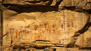
Well worth the effort. - Sego Canyon (Stage 3). There is so much rock art along the first three stages of the UTBDR that it is essentially ignored in favor of making forward progress. Sego Canyon - while slightly off the route - is more than worth the hour it takes to experience.
An ancient canvas. - Wildlife. This will change from year to year and place to place, but always be on the lookout - we very much enjoyed seeing moose, deer, sheep, bighorn sheep, and numerous flying creatures over the course of the trip.

Yes, I am the cutest little deer that you have ever seen.
Lowlights
It's really hard to come up with meaningful lowlights for the Utah BDR as I feel that many of them are particular to our personal situation.
- Nine Mile Canyon (Stage 4). Even more than Sego Canyon, Nine Mile Canyon is a magical place. The fact that the BDR passed through part of the canyon, but both skipped the majority and never mentioned stopping at even the most obvious panels was a huge miss in our book.
- The Final Stage (Stage 6 - Evanston to Garden City). As a final stage, this one was a let down. The terrain was essentially the same (though slightly less dramatic) as what we'd seen on the previous stage. (Note: this stage might be better if the route was run north-to-south) The fact that it ended before reaching the Idaho BDR was just lazy. And, like many final BDRs, the pavement-to-dirt ratio on this was simply too high.
- The "mainstream-ness" of the first two stages (Mexican Hat to Monticello to Dewey Bridge). This is particular to our situation, but we'd seen much of what these stages had to offer on previous trips to southeast Utah. If - like us - you've explored the area around Moab and on Cedar Mesa before, know that you might not see much "new" stuff on the BDR. On the flip side - if you haven't explored the area, this lowlight could quite possibly be the highlight of your experience!
The Whole Story


")


Love Backcountry Discovery Routes? Check out
BDRs we've run
to find your favorite.


")
")
")


")
")
Thanks for the summary. Hopefully I’ll be able to return to Utah in one year (after Labor Day) to explore again, and definitely will be spending time in Sego and Nine Mile canyons.
Hope you can make it back there. Sego and Nine Mile are amazing places, be sure to check out more than just the "main" panels - there's so much to see if you just venture a bit off the beaten path.
Excellent write-up sir. The devil is in the details and your details are spot-on. Two thumbs up.
Awesome, thanks Travis, and glad you enjoyed! ?
We've got to get to Utah! Unfortunately, the only times that I've been there was in a Ford Mustang, so off HWY exploration wasn't in the cards. Planning trips to potentially hot areas is complicated for us due to having to plan trips at least 6 months out and having a black truck with no A/C. Thanks for keeping us dreaming of that next trip while we're stuck doing the grind.
Utah's a great place for sure; definitely won the landscape lottery as far as states go! You definitely need to get there!
Having a black truck with no A/C will certainly limit when you want to be there, though. I just got back from a week driving around Capitol Reef and before that, I spent a few weeks (one, two, three) in the Cedar Mesa area (it's been a lot of Utah this spring!). I'd say that you're looking at a mid-March trip to some non-snowy red rock elevations as your best bet with no A/C. Nights will be on the cool side, but 50-60°F temps during the day will be pleasant and allow you to moderate temps with the windows.