
Having woken up at what @mrs.turbodb continued to remind me was 5:15am Real (Pacific) Time - and admittedly early given our long day of driving to reach British Columbia's Kootenays the previous evening - we completed our exploration of Doctor Creek FSR and rolled into Radium Hot Springs only a few minutes after 10:15am. Having enjoyed an ice cream at Screamers the last time we were through, this was high on our list of places to revisit, even if it meant a slightly later start to the hike we'd planned for the bulk of the day. Plus, ice cream is full of healthy stuff like milk and energy - sure to help us on the 2,500 foot ascent.
Everything was going fine until we perused the flavors on offer and discovered that only blueberry was remotely "normal." Other options - like Tiger Tail - were combinations like orange+black licorice. For us, it was a pass, as we retreated to the Tacoma, and continued north on BC-95 towards the Bugaboo Mountains.
Exiting at the town of Brisco - and once again at the site of a wood mill - the distant views were promising, though I must admit that the elevation differential was slightly intimidating.

These were not the mountains we'd be hiking in - the Bugaboos were behind and out of view - but they still presented a tantalizing preview of what was in store.

Throughout the trip we'd encounter several inhabited Osprey nesting sites.
For anyone unfamiliar - like us - with the Bugaboos, I think it's safe to say that the FSR of the same name sports views that are rather misleading. For the first 27 miles - which is in fact a single mile shorter than the length of the road - the Bugaboos themselves are not visible. Instead, the lower range to the east - while grand it its own right - blocks the view.

A normally spectacular view.

Barely worth stopping for, once you know what's ahead.


The color of Bugaboo Creek hinted at what we would find at the headwaters.

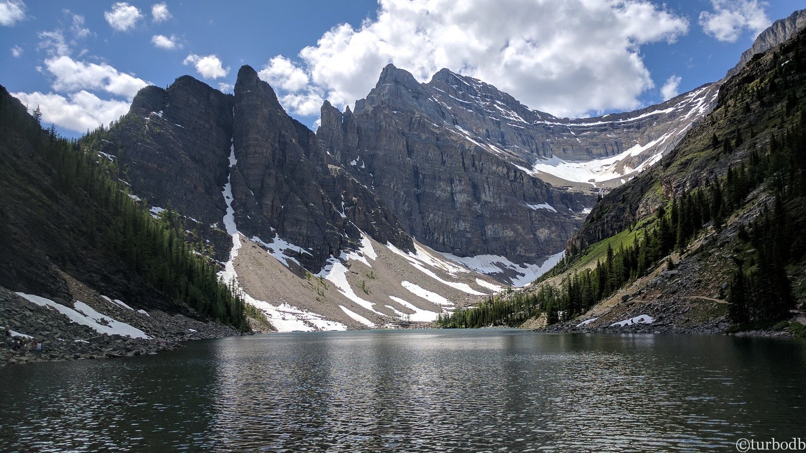
Making our way up the valley, it looked like so many others that we've explored.

With a little elevation, the glacier-carved U-shape becomes strikingly obvious.
Three-quarters of the way to the parking area - where we'd transition from Tacoma to leg-powered propulsion - an inconspicuous sign on the side of the road caught our attention. In fact, it may not have been the sign at all that initially registered as we raced by, instead, I recall the picnic shady table that looked like the perfect spot for us to eat lunch. This turned out to be a lucky turn of events, as the picnic table was perched at the apex of Bugaboo Falls. With glacial water racing over the edge and thundering into the plunge pool below, the roar was deafening as we worked our way to the water's edge.

Warm temperatures and substantial snowmelt had Bugaboo Falls raging as we gazed up from below.
It was also from the falls - where I sent the flying camera into the sky as I waited for @mrs.turbodb to assemble her sandwich - that I got my first glimpse of what we were really in for. Looking back now, I don't think the magnificence of the panorama fully registered at as I snapped a few photos from various angles; it was just a distant ridgeline and glacier that I figured to be a backdrop to our destination.

Bugaboo View.
It was 1:00pm when I landed the drone and we sat down to enjoy lunch. Even as temperatures climbed toward the day high of 88°F, a combination of the shade and breeze generated by the rushing water made for a pleasant meal. Still, we knew it'd be even hotter when we arrived at the trailhead, and hotter still as we worked our way up the 2.5-mile long trail as it climbed 2,500-feet in elevation.
Half an hour later, we were making the final approach to the parking area, unaware of the mayhem we'd find there.

This is where it finally registered that we were going up there!
The parking lot for the Conrad Kain Hut - and access to the Bugaboo traverse - was packed. We knew that - especially given our late departure - we wouldn't be the only ones on the trail, but neither of us expected to see 50+ vehicles, every last one surrounded by chicken wire to protect the wiring from the marmots that frequent these areas and have a taste for copper.
I have no idea if marmots are as much of an issue as the Home Depot warehouse quantities of fencing suggest, but we quickly found a few rolls of material - that a previous traveler had left behind - and wrapped up the Tacoma as diligently as we could.

Some other truck is probably tastier, marmots.
Just after 2:00pm - with sunscreen applied and camera gear loaded - we were off.
Our average hiking speed tends to be somewhere between 2.5 - 3 miles per hour until frequent stops for photos drop the average to a whopping single mile every sixty minutes. Still, as we ticked off the first couple of Canadian kilometers, we marveled - prematurely - at how nice the hike was so far.

Along boardwalks.

Micro-fern carpet.

These Yellow Coral Mushrooms are always so fun to find.
Every now and then we'd get a break in the trees and the glacier-wrapped granite spires of the Bugaboos - we were now squarely in the Provincial Park - would peek out and startle us.

buga-Boo!


A rustling next to the trail had me thinking - given our usual haunts - rattler! But no, this was nothing of the sort.

Still in the trees but gaining elevation.
The first couple kilometers behind us, the trail began to climb significantly. In fact, all those couple easy kilometers did was concentrate the "up" into an even shorter distance. Our pace slowed dramatically, and at points - though this never ended up happening - @mrs.turbodb even wondered if she would make it to the top!

Chains along the trail reminded me of Angel's Landing in Zion National Park.

Did someone say things got steeper? Perhaps stairs are in order.

Stairs not steep enough for you? How about a ladder now that your legs are jelly?
Eventually of course, suffering one foot in front of the other can't help but to make forward progress, and a little after 4:00pm, we reached the high-point of our adventure and got our first glimpse of the Conrad Kane Hut.

Still quite a way to go, but dang, that's cool!
At this point, I sort of went crazy trying to take photos of this amaing cabin up here at the edge of the glacier. Apologies, but with the effort it took to get there, you - my dear readers - will have to suffer through the lot of them.

Wow.

Still wow.

OK dude, we get the point. No need to keep hiking up.

From this angle, you can really start to get a sense for the size of this cabin. Three stories!

Backside view. Or front, I suppose.

Valley below.
Conrad Kain was one of Canada's most respected and beloved mountain guides and is regarded as a pioneer of modern guiding in both Canada and New Zealand. Thanks to his skill and engaging personality, he attracted exceptional clients who partnered with him in 62 or more first ascents in the Rocky Mountains and Purcell Range and another 29 in New Zealand's Southern Alps.
Dedication sign on the wall of the cabin.
Kain was born August 10, 1883 in Nasswald, Austria. As a young man, he trained as a mountain guide and led many classic routes throughout the Alps and Corsica. In 1909, he emigrated to Canada to serve as the first professional guide for The Alpine Club of Canada. In that capacity, he led the first ascent of Mount Robson, the Rockies' highest peak, in 1913.
In 1910, he accompanied the first expedition across the Purcell Range the Bugaboos. He would subsequently become the premier guide in the Purcells, leading clients up the range's highest and most difficult mountains. He completed five first ascents on the technical granite of the Bugaboos, including Bugaboo Spire in 1916, which stands as a landmark in North American mountaineering.
The man. The legend.
Kain displayed a passion for nature and solitude, often trapping alone in the wilds of the East Kootenays. Following his marriage to Henriquita (Hetta) Ferrara in 1917, he settled in the hamlet of Wilmer, B.C. and worked as a mountain guide, outfitter, hunting guide and fur farmer.
During the final decade of his life, he traveled on several climbing expeditions with J. Monroe Thorington and outfitted trips into the Purcells in search of the true source of the Columbia River.
Conrad Kain died on February 2, 1934 following a brief illness, and less than five months after guiding his last first ascent in the Purcell Range. In 1935, Thorington published the story of his life in the book Where the Clouds Can Go, which remains a Canadian mountaineering classic.
Several peaks in Canada and New Zealand are named in Conrad Kain's honour as well as a hut in the Bugaboos and a park and cairn in his hometown of Wilmer.
BCParks Info Sign


A well-appointed kitchen.
Initially - after discovering the cabin online and learning that we could spend the night - @mrs.turbodb and I had shared a look of shock when we discovered that it appeared to be un-booked on the evening we planned to complete the hike. However, we quickly realized - after slowing down to actually read the reservation page - that the cabin sleeps 35, and only a single spot was still up for grabs.
"There are not enough mattresses for everyone in the cabin. Make a new friend and share."
The second and third floors were dedicated to sleeping, and I got a kick out of the note on the ladder leading that led up.

Million dollar view from the front porch.

Treacherous route higher.
We wandered around at the cabin for only a few minutes. We'd made good time - all things considered - getting to the top, a fact that compelled me to suggest that if we made even better time on the way back down, that we might be able to reach camp - a few hours away - before sunset.
That was a completely unreasonable time to reach camp - sunset was at 9:37pm - but it would set us up well for an even longer hike, with even more elevation gain, the following morning, so we pushed our aging knees down the trail as fast as they would hobble.

Mikey the mini-marmot was enjoying the fresh water near the cabin as we left. "Good riddance," he seemed to scowl, "but leave your trail mix and car wires."

Back down we go.
Ultimately - mostly by way of me wondering how my knees could possibly survive another 50 feet of descent rather than taking pictures - we made it down to the Tacoma in under two hours and with just enough time to race south as the sun plummeted toward the horizon.


Water and time.
Our destination was one we'd visited in the past. A place that'd seemed so glorious when we arrived and then - as darkness fell - unleashed one of the most vicious storms we've ever endured. A place that experienced a good bit of drama less than a week after our departure. A place introduced to me as "The Glacier," and known to locals as Farnham.
We had no idea what to expect as we raced up Horsethief Creek, we only hoped it would be completely uneventful.
The Whole Story


Thanks for taking us along (virtually) to the Bugaboos, it is an awesome place. That vehicle wrapping at the trailhead was crazy, but Google say also common even for remote areas of Sequoia/King Canyon NP. I have recently added a chainsaw, now I need to look at vehicle size tarps. Seems the whole rodent family looks at our vehicles as a smorgasbord on wheels. Had not heard that marmots had a taste for vehicles. I had been warned that porcupines think radiator hoses are a great snack. And we both know mice/rats don't limit their diet to French cooking like the movie Ratatouille. In the last 15 years a number of auto makers (Toyota is one) switched over to soy-based wire insulation. It is biodegradable, renewable, and better for the environment, and guessing rodents find it even more to their liking. To me biodegradable does not sound like a plus for an off-road vehicle. 🙂
So, what you're saying is that as long as I park my dino-oil-based-plastic-and-rubber-clad wires and hoses next to a newer, say, eco-friendly Subaru or 4Runner, those little guys will head over there for their munchies and my truck will skate by unscathed?
Looks like I'll be buying some peanut butter to spread on undercarriages to point them in the right direction, along with one of those vehicle-sized tarps! 😉
Hmm, a peanut butter diversion, excellent thinking colonel I see that the Mineral King trailhead has a real problem. Waiting for a sale on HF's big tarp. I would sure be bummed if my first hint of the issue was pulling into a parking lot for a few days stay and seeing this.
lol, I totally get that bummed feeling, since our first hint was pulling into a similar looking parking lot. I was very relieved to find quite a bit of abandoned chicken wire that could be utilized. Of course, one cannot rely on such luck at all parking lots.
Shout if you see the sale, I need one too.
A few years ago squirrels ate the wiring harness in our brand new car out here in the desert (in our driveway), $9,000+ to replace so I took measures to get rid of them & also sprayed the wiring of our vehicles with a repellant made for the job. Yes, have done Angel's Landing a couple of times, spectacular, but no nice hut up there. I'm amazed at what an engineering feat it must have been to build such an amazing and beautiful place high in the mountains. Spectacular country and very nice photos. Thanks for sharing.
ugh, in the driveway! Bummer. Curious what repellant you used, as I should probably pick some up to store in the Tacoma for trips like this.
(Interestingly, I've done many trips over the years to marmot-infested lands, and before this trip, I never really knew it was an issue, or at least as large of an issue as it is apparently. I've just been lucky I suppose, but now that I know, relying on luck seems... unwise.)
OK, I just checked it out. The stuff I bought is "Natural Armor All-Natural Engine & Vehicle Rodent Defense." I got a gallon from Amazon for $29.95. Walmart also sells it but it's not in store, I don't know any store that stocks it. It seems to work well, just spray it all over the wiring, it's not harmful to anything else and it has a nice peppermint smell. The smell of apple cider vinegar also repels rodents so I put some in an old coffee can with a screen over the top and sit it under the front of my truck and haven't seen a squirrel in my yard since I started doing that about 3 years ago but have seen a squirrel in the neighbors yard on the other side of the block wall so figure that the vinegar may also be working. Attached is an image of the Rodent Spray. I've used it every few months and still have almost half a gallon so it goes a long way.
Just noticed that Amazon also has something called Honda replacement rodent tape which is a lot more expensive at around $45 so evidently some auto makers know about the problem. I talked to a mechanic and said the problem is the newer vehicles started, a few years ago, using wiring that has plant based insulation that animals like, plus the rodents like the warmth of the engine compart and gnawing on the wire itself grinds down their always growing teeth. It's a win-win-win thing for the little bastards! LOL
Gorgeous photos! Thanks for sharing.
FYI It’s not car eating marmots we worry about in the East Koots. It’s the porcupines.
Thank you, glad you enjoyed!
And, really, porcupines do it too, huh? Man, it's like all of nature is out to get us... or at least our vehicles. Even the trees and understory are always reaching out to add pinstripes. 😉