
Waking up near Aiken Cinder Mine turned out to be glorious. The calm night meant plenty of sleep, and I was well-rested when I climbed down the ladder to greet the orange line creeping up behind the old crusher.

The next hour went by quickly as I walked around the mine site, colors changing constantly as the light and dark battled in the sky. In an already remote place visited by few, this was a time that I knew even fewer ever experienced. The silence of change.


With the sun finally above the horizon, I whistled down to @mrs.turbodb who'd been enjoying the show - and her book - from the coziness of the tent. She climbed out to prep breakfast and lunch for what we hoped would be a long day of exploration through one of the most remote and least visited sections of the preserve - Devils Playground.
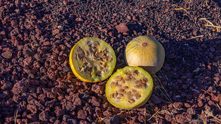
As she did, I packed away the Mt. Shasta CVT - much easier on a calm morning with temps in the 40s°F rather than high 20s°F with gusty winds! And then, we loaded up to move out - one quick stop at an old tractor that neither of us remembered, and another to inspect some desert melon - before pointing ourselves south along Aiken Mine Road towards our destination.


Down through the youngest domes in the Cima volcanic field we continued to lose elevation at a rapid pace. We found ourselves underground - hoping to catch the sun's rays streaming through the skylights of the lava tube - just after 8:30am. We were much too early - the alignment not occurring for several hours - but still enjoyed our time exploring the cave.

From our camp at 4000 feet above sea level, we'd ultimately find ourselves at just over 1200 feet as we threaded our way down Jackass Canyon - its mouth spilling out a few miles east of Devils Playground.


From our current position, a power line road stretched for four miles across the alluvial fan that spilled out of Jackass Canyon. This section of road was one that we'd been warned about - the desert winds blowing fine sand into deep drifts that can make it impassable, even with 4wd. If that were the case today, it would mean adding eight additional miles to our hike - something that neither of us wanted!
Walking the first quarter mile of sand, it was certainly fine and the drifts were in fact several feet deep. Rarely visited, there were no previous tracks. Still, I hoped that with a bit of speed, the ability to further air down our tires, and a set of USActionTrax recovery boards in the case of emergency, I figured that at the very least, we could slowly work our way out of any situation.


Excited that we wouldn't be walking eight extra miles in the fine sand, we now found ourselves at the foot of the third largest dune complex in the country. It was - however - a bit less impressive than we'd imagined. Unlike dune fields like Eureka Dunes in Death Valley, and even the Preserve's own Kelso Dunes to the south, these are not entirely made of sand - the volcanic material over which the sand had blown, still visible in many places. As well, where there was sand, it was largely covered with grasses and desert shrubs.
But - the draw of this place - for us, at any rate - was the solitude. Unlike every other dune field I've visited, there were no footprints on these dunes before we set out to explore.


Initially, we chose our direction based on a route suggested by Digonnet, heading north towards an isolated dune some two miles across the valley. Quickly though, the more intelligent of our group suggested to me that perhaps we should simply wander in the direction that seemed most interesting - creating our own story as it were.
And so, we turned west - immediately into the dunes - views of the Bristol Mountains omnipresent as we scaled the undulating ridges

We planned a few routes carefully, ensuring that we could reach local summits without disturbing the pristine ridgelines. As we did, the Canon 80D snapped away, the intervalometer taking a photo every few seconds as we posed at the top.

And then, I had the pleasure of running down! Ruining the ridges like this disturbed me at first, but I realized that with almost no traffic and plenty of wind, there'd be no indication I'd been here, in just a few days.
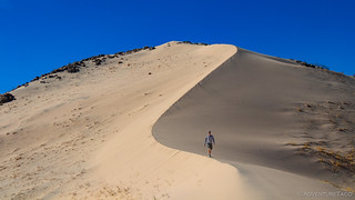
We wandered for several hours - up and down through the dunes and rocks, sand finding every nook and crevice in our shoes. When we were hungry, we found a spot at the top of the highest dune, the sun at our backs and as we feasted on food and views spread out before us.


Eventually, we decided it was time to head back to the truck. We'd covered several hard miles through fine, soft sand - only a fraction of the playground for sure - and had those same miles to retrace before we'd be done. Of course, in such an expanse, our route back was far from the same as the route out - plenty of new things to see on the return trip.


Through it all, one of the constant - and most interesting - directions to look was always down. In a place like this - the landscape seeming barren and monotonous - nearly all of the action happens on the ground. The tracks of lizards, beetles, and rabbits crisscrossed the dunes. Through it all, the world's largest eraser left splendid patterns painted across the land.


A couple hours later, we arrived at the truck, our first order of business to clean the sand - as best we could - from the lower halves of our bodies. I'd set up the solar system while we were gone, charging both our laptops, keeping the fridge cool, and topping off the dual batteries to boot - some 200Wh of free energy generated in our absence.
That's right, I'd recovered approximately three cents of power. 
Once we'd dusted off and cleaned up a bit - the warm afternoon allowing us to wash our faces and nether-regions in something other than the freezing cold of night or morning - it was time to make a decision on where to go. The route I'd mapped via Google Earth had us retracing our path through Jackass Canyon, but we'd spotted a road from the top of the dunes that looked as though - if we could make it through the deep sand - it might get us to the Union Pacific Railway that runs east-to-west through the desert.
We set off to see if we could make it.

If we did, we would save us dozens of miles and a couple of hours of driving. If not - well - we had enough time to turn around and make our way back. Worst case, we'd get stuck in the sand and camp in the middle of nowhere. And of course, we were going to camp in the middle of nowhere, anyway. 
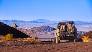
The road turned out to be no worse than the one we'd taken into Devils Playground, and by 3:30pm - a full hour before sunset - we were essentially at camp for the night. Well, not completely. See, I was contemplating my next modification for the Tacoma - railroad wheels - and @mrs.turbodb was more nervous than any other time on the trip - though to be clear, we could see miles in each direction when she yelled out the window to, "stop pulling this little stunt." 

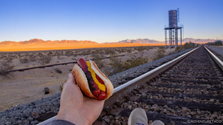
Having completed our journey for the day, we decided on a camp site just south of the tracks near Kerens but refrained from setting up camp just yet. Instead - hoping for a train to come through as the sun dropped below the horizon and color splashed across the sky - we grilled some hot dogs and ate them in a rather unique location.
Alas, we'd missed the last train before sundown. Not wanting to set up camp in the dark, we pulled into our designated spot - which was any spot we darn well pleased - and settled in for the evening.


It was 5:30pm or so when I remarked to @mrs.turbodb, "That sounds like a Tacoma." Sure enough, a few minutes later, a silver second gen Tacoma pulled up to an abandoned pump station between us and the rails. Wondering out loud, "Who could be out here at this time of night?" we kept to ourselves as the driver got out to explore the small building, before heading back the way he'd come - toward Kelso.
Upon our return, I'd discover that it was @mk5 (!), having seen our APRS and driven out to say hi! Not seeing any signs of life - our decision to keep to ourselves - he did the same. A missed opportunity for us both; an near meeting that we'll need to rectify on a future adventure.
Eventually, a train did rumble through - first from the east, then from the west - every two hours or so, all through the night. Our earplugs in, they didn't bother us at all.


