
Unlike the previous night, the wind at the mouth of Caruthers Canyon never abated, making for the worst sleep of the trip. Tossing and turning as the wind buffeted the tent, I was glad when my alarm went off - simply because it meant I could be done trying to sleep.
Update: August 2023
The York Fire (wikipedia) (inciweb) has burned through Caruthers Canyon (and more than 93,000 acres), changing the landscape for our lifetimes. I visited again in December 2023, and the aftermath was stunning.
An orange glow just poking up over the horizon, I climbed out of the tent and quickly wrapped myself in all the warm clothes I'd brought along - the tent at least affording me warmth under the down comforters.

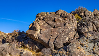
Luckily for me, Caruthers Canyon is one of my favorite spots in the park - the granite spires reaching high, wonderlands of rock popping up through the trees. Even on a cold, breezy morning, it was a true pleasure to watch the sun slowly illuminate the landscape, the long rays coloring everything around.


With our limited light now ticking away, @mrs.turbodb was soon out of the tent and we munched on our cereal as we discussed the plan for the day. We'd driven up the canyon when we'd arrived in the dark the evening before - hoping to camp in an area that was a bit more sheltered - but the site was already occupied. Still, I wanted to head that direction again - just for a few minutes - to see a balanced rock reminiscent of the heads on Easter Island. So, that's what we did.

Originally, I'd planned for us to hike Caruthers Canyon - to the divide with Keystone and Sagamore - but having done that the previous day from a different direction, we choose to head back out and get and early start to the rest of our day!
Like squirrels in the bulk food section, we were distracted almost immediately. A road - one not on any of our maps - led away from the main drag toward the New York Mountains. Where did it go? We decided to find out.

Predictably, it terminated a mile or so later at a reasonably nice camp site, where a family of mule deer were munching on their morning meal, wondering who the heck we were to intrude on them like this.

We watched them for a while, and then had a bit of fun ourselves in the morning sun, before turning the truck around and heading south to New York Mountain Road, Table Mountain rising prominently in the distance.


New York Mountain Road turned out to be in great shape, and it was good fun racing along at 35mph, the reasonably-newly-installed limit straps in the front alleviating any concern around over-drooping the front suspension and coaxing us faster. As a result, we soon reached the intersection with the Mojave Road at Rock Spring - a place we'd been before, but that I only recently discovered contained petroglyphs.

Given everything else in our full schedule, the idea had been to find the petroglyphs and then continue on our way. But, like everything else on our schedule, we ended up enjoying the hike through the small canyon - eventually finding ourselves a mile or so from where we started, meandering our way up and enjoying the scenery. #ThisIsTheWay


There were - no doubt - several rock carvings and art that we discovered. Near the mouth of the canyon, Stuart - of the 4th Infantry - left his mark on May 16, 1886. Near the upper end of the canyon, more contemporary visitors unfortunately did the same.

Along the way, we also found those that we'd come in search of. Or, more precisely, some actual petroglyphs - as we didn't know if there were more that we missed. Rather faint, it was hard to tell what they were trying to depict - and we were reminded that many times, the joy is in the search - regardless of the outcome. It wouldn't be the last time - even on this trip - that we'd be reminded of this important fact!


From Rock Spring Canyon, we turned the Tacoma west along a short section of Mojave Road. This section - wide and well travelled - brought us down out of the Lanfair Valley and into the Kelso Basin. In the distance, the road continued - its size greatly diminished after crossing Kelso-Cima Road.
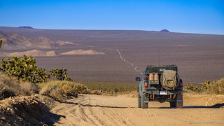
We - however - were not going that direction. Instead, we turned north on Death Valley Mine Road, toward the tiny enclave of Cima, and ultimately Teutonia Peak. This is one of the most beautiful roads in the preserve - Joshua Trees, yucca, several types of chollo, and more all packed tightly together - a true garden of spikes.

As we passed the Death Valley Mine itself, we made our last pre-lunch detour.  We'd been here before - and the history of this curiously named place is worth reading - but it'd been extremely foggy at the time, and I couldn't pass a quick peak with the sun shining.


Headed north once again - Teutonia Peak now visible in the distance - our conversation pivoted from history and geology to a much more modern-day concern: fire.

It's hard to tell in the photo above, but if you know what you're looking for, you can see a small fraction of the devastation - the darkened Joshua Trees in the distance - from the Dome fire of 2020. Sparked by lightning from a series of dry storms, and with the help of gusty winds and dry conditions in the following days, containment of the fire was challenging. More than 43,273 acres of Joshua Tree forest centered around Cima Dome burned.

At the time of the fire, many who care so much for these desert sanctuaries were understandably distraught by the devastation to this special place - the density of Joshua Trees here, rivaling that of any other location. Interestingly however, as Ken @DVExile pointed out - from an article that he found - the Joshua Trees in Cima may have achieved their density only because of grazing. The cattle don’t eat the (native) blackbrush which is a nursery species for Joshua Trees. As a result, over time, far more blackbrush existed than usual, in turn leading to far more Joshua tree seedlings reaching maturity. So, these unusually dense Joshua tree forests - though they have become iconic - are perhaps not natural to begin with!
Not that this realization made driving through the burned forest any less shocking.


We arrived at the trailhead for our hike up Teutonia Peak just right around 11:15am. With the sun shining and both of us already hungry, we decided that it would be the perfect spot to have lunch before setting out on the short - but still steep - climb to the top. It was our understanding that this was one of the busier hikes in the preserve, but as we lounged in our chairs enjoying tuna and chips, no one passed us - the fire having consumed not only the vegetation, but also much of the desire to hike the Teutonia trail.
Our bellies no longer grumbling, we set off along the trail, the narrow path clearly a line that had been used to fight back the flames.

We also visited the site of the old Teutonia Mine and Toegel City - now lost to time forever


And then, we began our climb. All alone in an area usually full of hikers, our experience was one that I think we'll never forget - a unique opportunity not just to reflect on the devastation, but also to marvel in a landscape that not many will ever see. Because - while recovery may seem slow to us - the desert will reclaim this place more quickly than we think - new plants and wildlife filling the void.


It was only as we neared the top that a few survivors remained - the rock-to-plant ratio high enough to protect them from the flames. A reminder that even the desert can look lush under the right circumstances.

The views from Teutonia Peak were unworldly. The foreground a sight seen by few, and far in the distance to the north - Death Valley National Park's Telescope Peak.

The summit achieved, our downhill scramble to the truck passed quickly, the lack of people - even on a Saturday - still a bit of a surprise to both of us. We weren't complaining - hiking without face coverings or maintaining distance from others is a much easier proposition, and one that we were happy to take advantage of on this beautifully sunny day.

Teutonia Peak now in our rear view mirrors, our route had us heading west through the cinder cones, but not before stopping for fuel, where Cima Road intersected I-15. And so, as we plodded along the 20 miles or so of pavement, our tires aired down and so our speed reasonably slow - we both noticed an Audi A3 that looked strangely situated off the side of the road.
Pulling along side and donning our masks, we rolled down the windows to inquire if they needed help. Sure enough, they did - having pulled off the pavement and into 10" deep sand to "take a break" from driving. Oops.
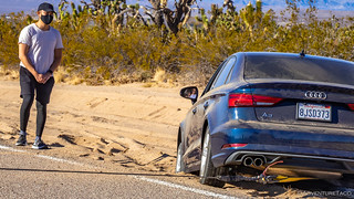
And so, for the second time in as many trips, we whipped out a short tow strap, clevis, and the winch - and pulled a vehicle out of the deep sand along Cima Road. It took less than 10 minutes this time around, with a masked smile and "thank you," the no-longer-stranded-travelers were on their way.
Half an hour later we'd filled the tank with fuel and headed west into the Cima volcanic field. Covering 60 square miles between the the Ivanpah upland and Kelso Basin, it was named a National Natural Landmark due to geologic significance in 1973. The 40 cinder cones (volcanoes) range from 7.6 million, to a mere 10,000 years old.

Aiken Mine Road - the only road through this protected area - skirts the north end of Cima Dome and gave us yet another look at the fire that we'd experienced most of the day. For nearly half an hour we drove along, everything on the south side of the road blackened, while to the north it was as though nothing had changed.
Ten miles in, I spotted a windmill a little way off the road, and I woke @mrs.turbodb - who'd dozed off after an eventful morning - so we could go take a look.

Well, this slight detour turned out to be another of our blessings-in-disguise, because as we re-joined the Aiken Mine Road, we happened to spot what looked like some sort of encampment at the base of a cinder cone several miles away. As @mrs.turbodb tried to match up map- and real-world-topography, I pulled out the binoculars and excitedly related that it appeared to be an old mine - or, perhaps even an active site.
With the afternoon wearing on, we now had a decision to make - go explore the newly-discovered-and-not-yet-identified mine, or continue on to find camp further down the Aiken Mine Road. Yeah, you know what we chose. 

The mine we'd stumbled upon was the old Cima Cinder Mine.
Located in 1948 by Emerson and Fay Ray, the Cima Cinder Mine was a successful family-owned operation. Its only known production of 130, 000 tons between 1954 and 1961 likely reflects a mere fraction of its total output. Yet it ended on a very sad note. It was still running in 1994 when this area became a national preserve. Soon after, a coalition of environmental groups threatened to file a lawsuit against the NFS unless the mine was shut down. A main concern was the endangered desert tortoise, which the coalition claimed was threatened by mining activities. To forestall the lawsuit, in August 1999 the NFS evicted the owners, after 50 years of operation - for trespassing...Hiking the Mojave Desert
We spent some time exploring the old mine camp - the single wide, a graffitied trailer, a cinder block house, and several old vehicles all left to rot when the mine was cleared out.


As we explored further, we made our way towards the heart of the mining operation. Similar to the Aiken Cinder Mine that we'd explored on our last trip to this region, a large scale was the first structure we passed. Used to weigh material for before it left the mine, its calibration has lapsed over time, registering the Tacoma at exactly zero pounds.

Finally, we headed up into the cinder cone to explore the workings of the mine. Unlike many of the other mines we come across on a trip like this, a cinder mine consists - essentially - of scooping the cinder off of the side of a mountain. Once the top layer has been removed, the rest of the mountain is the ore, ground and separated as necessary for various uses at a large crushing and screening plant.

Even the large machinery belies the size of an operation such as this. On a platform above the plant, a huge section of the volcano had been carved away - the layers of cinder now exposed, giving us the ability to see what it was like inside this volcano.


Our last stop before heading back was at the mine's old scrap yard. There, old trucks, tractors, conveyors, and other equipment that no longer worked but contained valuable parts were still parked - rusting away as the decades passed.

By now, we had only half-an-hour or so of sunlight left - not long at all to find a camp spot. We high-tailed it back to Aiken Mine Road and discussed where to camp as we headed west. Ultimately we decided that camping near the Aiken Mine would be a reasonable spot - allowing us something to explore in the morning, as well as both sunset and sunrise views due to the raised platforms of cinder.
We arrived just in the nick of time, the truck positioned so we could enjoy the show right out the windshield to our heart's delight.


As the light along the horizon waned, we enjoyed a no-cook dinner: pasta salad for me, and Spanish tortilla for @mrs.turbodb as we watched an episode of Long Way Down on my phone - a great show that I highly recommend for anyone who loves motorcycles, adventure, and friendship.

We spent a couple more hours in the truck - putzing around with photos, knitting, and reading before calling it a night and heading up to bed. The wind that had plagued us in the northeast part of the preserve was nowhere to be found - a relief to both of us as we nodded off to sleep.
It was sleep that we'd need the following day - our plan the most ambitious yet: if the Tacoma could manage the sandy roads, we'd attempt a 12 mile hike through the heart of Devil's Playground.


I'm not ready for this episode to be over! I love following your adventures. I want to explore thosr cabins at Death Valley Mine!
Thanks for coming along John! There's more to the trip, if you want to sign up for notifications ? https://adventuretaco.com/subscribe/
I love the Mojave. I visited and walked the Teutonia Peak trail in the summer of 2019. It was such an incredible place. The Dome fire broke my heart! Also, that family owned mine being evicted for trespassing after 50 years...what a sad world sometimes. But I still really enjoy the AdventureTaco blogs. Thanks for the content!
Thanks for the kind words Jon, I'm glad you found and are enjoying the stories. Sorry to hear about your family owned mine - would you mind sharing which one it is, and is it one that we could visit on a trip down to the Preserve sometime? And I understand if you don't want to share it publicly - perhaps via email if that's the case (Contact me)