
The 20-hour drive home - that concluded our Lowest Peak in the Park - aka Into the Owlsheads trip - gave me a lot of time to think. The trip had been brilliant, with some predictable highlights, and some unexpected surprises. And I have to admit that joking around as we climbed Owl Peak - that it was the lowest in the park, perfect for the serial underachiever - had been a lot of fun.
But it also got me thinking. In the nearly four years that I've been visiting Death Valley, Owl Peak is the only summit I've ever climbed. And, I thought, what if I followed it up with the highest peak in the park? I mean, by doing the lowest and highest, it sort of follows that one has done them all, you know?
And so, now less than two weeks later, we're headed back. To hike to the top of Telescope Peak, and to explore areas in the Panamints - areas that we've driven by many times, but always enroute to somewhere else. Not this time though - this time, we're Pushing into the Panamints.
The trip got started as the previous one concluded - with a 20-hour drive. And so, a few hours after midnight we once again found ourselves setting up camp just outside of Beatty, NV.

On the drive south, a milestone. The Tacoma is finally getting broken in, now 22 years after I rolled it off the lot.

We woke up the next later in the same morning to blue skies and pleasant temperatures.
Topping off the fuel tank in Beatty, we headed into the park and coasted our way down Daylight Pass. For the first time ever - and to the surprise of my passenger - we didn't stop at the Death Valley entrance sign, an indication of how recently we'd been in this exact location.
Approaching CA-190, the Mesquite Dunes sprawled across the windshield and it was time for our first ad-hoc itinerary modification. We've driven by these dunes numerous times, but like many of the places we'd visit on this trip, we've never stopped. And it was time to change that.

Mesquite Dunes, with white-roofed Stovepipe Wells and the Cottonwood Mountains in the distance.

A few minutes later we pulled into the nearly-empty parking area, the near-dunes sporting their namesake plant life.
We ate a quick breakfast and slathered ourselves in sunscreen before heading out onto the dunes. I have to say that neither of us really had a plan at this point, since we'd not planned this stop at all. On the one hand, it might have been cool to get to the highest dune - two miles from the parking lot, near the center of the dune field. On the other, a less obvious route could offer us virgin sand, and a (more) unique experience than is perhaps the norm.
After a quick discussion, we altered our trajectory and headed for a series of dunes off the beaten path. They were still tall - perhaps only 50-feet shorter than the highest - but we'd achieve plenty of elevation later in the trip -  - no need to rush things now.

Can't beat the sight of empty dunes framed by the Grapevine Mountains.
Walking through pristine dunes is both a blessing and a curse. Sand in the shoes, the inevitable back-sliding that comes with every attempted step up the slope of a dune, and the constant up-and-down just to make it a short distance - these things all suck. But, for me anyway, the gentle flow of the ridges, the wind-blown ripples of sand, and the opportunity to make the first tracks - those things easily make hiking in dunes worthwhile.

Mini dunes in a field of giants.
Finding our own corner of the dunes certainly didn't save us any distance from a hiking perspective. Eventually though, I found what I considered to be a suitably tall and yet still pristine field of dunes and I asked @mrs.turbodb to make her way to the top while I got the camera (more info on my camera gear) set up on the tripod.

Apparently, I don't cover a quarter mile quickly enough. Barely.

Second time is a charm. Good thing there was plenty of oxygen here at 10' below sea level to catch my breath.
With that, we were headed back - the time only 10:00am, but the temperature already climbing enough that we were ready to head out of the valley and into the Panamints to escape the worst of it. Our first destination: Mosaic Canyon.

Mosaic Canyon, where - apparently - everyone who comes to Death Valley goes to hike.
Passing - and thoroughly dusting, unfortunately - four vehicles on our way to the trailhead, we quickly got the hike underway so we could beat the crowds that were carefully making their way up the well-graded alluvial fan. Of course, the situation in the parking lot meant that we'd still encounter our fair share of other hikers, but such is life on a popular location like this.

Heading into the canyon.
The main formation exposed in lower Mosaic Canyon is known as Noonday Dolomite. A tan-colored dolomite, it forms the canyon's flat, tilted west wall (right side in photo above). Deposited in the late Proterozoic era - some 900 million years ago, when this area was flooded under an earlier incarnation of the Pacific Ocean - it was later buried under the Precambrian and Cambrian formations that now form the east wall (left side of canyon above). The burial process - as is common - resulted in extreme temperature and pressure on the lower layers, converting some of the dolomite to marble.

Marble outcroppings reaching for daylight, visible along the sides of the wash.

Part of the first narrows, where exposed marble adds an amazingly smooth texture to the already highly-sensory experience.

The sun, filtering down through the winding passages, adding layers of light and shadow to the already striated surroundings.

In a slightly wider section of wash, a large chunk of wall had broken off, now an island that younger hikers surely enjoy.
As with any desert wash, Mosaic Canyon is constantly undergoing change. Large floods in the 1950's and 1970's carried enormous volumes of gravel from the surrounding area, depositing the gravel into the canyon as the water slowed at its mouth. This has resulted in narrows that - while no more than a few feet wide in areas - are no longer as deep as they once were.

@mrs.turbodb demonstrates a railing and the few final steps of a bypass that was once used to climb around a dry fall that is now buried in the gravel below our feet.

I really like seeing the workmanship of previous generations. So functional and appropriate for a place like this, as compared to the more modern - and surely safer - installations I see sometimes today.
After the first narrows, the canyon opened up for a while before constricting once again into a second set of winding passages. These narrows - as is common in any body of water flowing over hard surfaces - also contained dry falls, most of which were fun and easy to scale, and which we thoroughly enjoyed.

Up a fanglomerate fall.

A smoother and taller marble fall added visual interest in the warm light of the canyon.
Eventually, the second narrows terminated at a 20-foot dry fall that is more than most will be willing to negotiate. @mrs.turbodb took a well-marked bypass trail around this fall, and then I decided that a scramble up the face - but not down, I'm not crazy  - would be a fun challenge.

@mrs.turbodb, a bit out of her comfort zone on the edge of the fall. I took the route up the diagonal shadow below her.
Not far after this fall, we found ourselves in an amphitheater with an even more imposing 25-foot fall. There was no climbing this fall - even for someone as foolhardy as me - and though a somewhat sketchy bypass trail does exist, we decided to leave Upper Mosaic Canyon for a future trip, calling this our turnaround for the time being.

I'm nearly invisible at the bottom of the large fall.
The hike down the canyon was just as visually stimulating as the hike up. I've tried to train myself to turn around more often - especially on through-or-loop hikes - in order to not miss anything, because it's amazing how different the same landscape can look, coming from the opposite direction.

A section of fanglomerate, worn smooth by water and gravel, now the mosaic for which the canyon is named.

The wide section of wash, aglow in color, with the Cottonwood Mountains rising in the background.

Layers of color.

At the first narrows, the fanglomerate that once compressed the dolomite into marble now clings to its surface as life rushes by.
Upon reaching the parking area, we enjoyed a lunch of chips and sandwiches in our new rocking camp chairs, views of Death Valley and the Cottonwood Mountains rising up to the north. It was nice to relax for a bit, each of us still tired from a night of not-very-much-sleep and a long day of driving the day before.
But, as is our habit, we didn't dally - we still had a couple places to be before calling it a day - and soon we were back in the Tacoma and headed into the Panamints along Emigrant Springs Road.
Soon enough we found our turn-off and I popped out of the truck to air down for the remainder of the trip, as we were now going to be largely travelling on dirt roads.

Certainly a nice view while airing down.

Let's explore Telephone Canyon, shall we?
Not long after starting along the Telephone Canyon route - which would ultimately take us to both arches and the old Tucki mine - the body of an old vehicle hinted at those who'd come before us. Hopefully - of course - our luck would prove more resilient than theirs!

Not a place to break down.

Starting up the canyon, the alluvial fan and Cottonwood Mountains behind us.

Car-sized fanglomerate undercuts were fun - if a little nerve racking - to drive under. What's the worst that could happen with a bunch of loose rock overhead, amiright?
Soon enough, we came to a fork in the canyon. Here, our road would head into the north fork, while the main canyon continued to the south - along a route that gave the canyon its name, as it was once used to run telephone lines between the (now ghost) towns of Skidoo and Rhyolite. In the early 1900's, these two towns were then the region's two largest - and frankly only - mining towns, and communication between them was important enough to complete a telephone line in 1907.
But we weren't here to see a telephone line, instead, we were here to visit a telephone-shaped arch, and the remains of an old mill.

Always a welcome sign.

A short way up the canyon, Telephone Arch - an unlikely arch of crumbly siltstone and fanglomerate.

An old arrastra at Telephone Spring, used to grind gold-bearing ore, resulting in a slurry of material that flowed into several settling ponds down the canyon.

Walls delineating the settling ponds.
We come across arrastra relatively infrequently in our travels, and to pair the viewing of one with an equally rare arch was - for me at least - exciting. Energized, we headed back to the Tacoma to continue on our way. Our final destination for the day - and our camp for the evening - was deep in the Panamints, at the site of the Tucki Mine.

Continuing up the wash.

Pushing into the Panamints.
I think one of my favorite things about Death Valley are the drives through landscape that many consider to be desolate. The sense of solitude, the knowledge that we are probably the only ones to have travelled this way in quite some time, the wonder about what could be around the next corner - those are the things that I really love about places like this.
For me - since my passenger was asleep at this point - that made drive through the north fork of Telephone Canyon extremely enjoyable.

A side road, which I figured I might as well check out - in order to allow my passenger a few more minutes of rest, of course - revealed a fabulous view down into Death Valley.

Compressing the background.
After cresting the ridge of the Panamints from the west, we dropped down a bit less than a mile onto the eastern slopes, and into the top of Tucki Canyon. Here, nestled into a hillside was the Tucki Mine. I quickly found a spot to park the Tacoma for the evening - it was only 4:00pm, but sunset was less than 30 minutes away - and hopped out to explore.

The lone standing cabin that remains at the mine site.

The interior is still in reasonable condition, though it may not be for long. One wall, and several sections of roof have been liberated - by either the weather or visitors, I'm not sure - in the last several years, exposing the cabin to the elements.

An entry from the log book, left by the NPS a couple years earlier. Intriguing!
Having spent a few minutes with the log book, my curiosity was piqued about the diggings and structures I'd seen on the hillside, so up I went to check them out.
The mine itself has a long history of intermittent activity. Claimed first in 1909, then in 1927, it was active off and on until the 1970s. Over its lifetime the property, which encompassed the four main Tucki claims, was leased and worked by at least half a dozen parties. The ore, mined underground, was first treated at Roy Journigan's Mill in Emigrant Canyon until around 1938. In April 1939, after selling his mill, Roy Journigan (of Journigan Mill) became part owner of the mine, which eventually became the family's property. Although it brought in nearly $18,000 in 1941, other active years were likely less productive. After the early 1950s mining was sporadic, until in 1975 Russ Journigan and a few partners installed a crusher and a leaching plant at the site to extract gold from old tailings. The operation recovered only a few dozen ounces of gold before it shut down and the equipment was removed in March 1976.Hiking Death Valley

One of the larger shafts, though not very deep.

A welcome view after working underground all day, I'm sure.

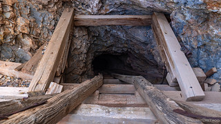
A precarious entrance.

The old headframe and ore chute of the largest workings.
The longest shaft, some 307 rickety ladder rungs to the bottom, and apparently now filled with bats! Stay out, stay alive.

Ore would be dumped from the head frame through the grizzly bars into the ore chute.
By this time, the sun had set, and to my west, a warm pink glow was filtering up the wash from Death Valley below. I figured it to be a good idea to head down to the truck to consult with @mrs.turbodb on the timing of dinner and the plan for the remainder of the evening.

A desert sunset.

The tailings pad made for the perfect(ly level) spot to set up for the night. The four bins were made of steel-lined cinderblock and used to leach the gold-bearing tailings, removing worthless mud to reduce processing volume at the mill.
Ultimately, we spent a couple hours in the truck - reading, knitting, processing a few photos - before getting out to make dinner and ultimately hit the sack a little after 7:00pm It was early, but we'd had fewer than six hours of sleep in the last 48, and we were both ready for the cool, windless night that was to follow.

An active camp.
The next day would find us pushing even further into the Panamints, exploring the most fantastic mill we've ever seen, and ultimately setting ourselves up for what would be the highlight of our trip. But that story is for another time...
The Whole Story


Love Death Valley? Check out
Death Valley Index
for all the amazing places I've been in and around this special place over the years.
Congrats on reaching 200k on your Tacoma, and I love the photos. I reached 171K yesterday while setting my cat monitor to pass California smog. All monitors are working except the cat monitor. The way things are going, I will probably hit 172k just driving around locally. LOL.
Great article, Death Valley is probably one of favorite places. We’ll be down there in January and then off to Baja for a month or so!