
As I transitioned from the middle segment of the Bradshaw Trail that'd ferried me across the Chuckwalla Bench, I was very much looking forward to the final - and shortest - segment of the journey. It was already quarter-to-five in the afternoon, so I only had a couple hours of light before I'd have to call it a night. I hoped that would give me enough time to find a great camp site in the Hauser Geode Beds. This spot - as with most of the other highlights of this adventure - wasn't on the main route, but was one of two loops at the very beginning of this segment, which I suspected would be the highlight of this portion of the trip.


Just as I was snapping a few photos of the pointy summit, I happened to notice a road entering from the east. This, I realized was the end of the second loop I planned to run - through the Palo Verde mountains and Clapp Spring - the following morning. As I continued south, I quickly found myself slowing down and putting the truck in reverse - perhaps swapping the order of my loops would be a better idea!
Making the last-minute decision to mix-up my ordering was based primarily on driving direction. As it was, driving to the Hauser Geode Beds would mean driving west-southwest, directly into the sun on the horizon. However, by heading east toward Clapp Spring, I would not only keep the sun at my back today, but I'd leave myself with a westerly journey in the morning, again with the sun behind me!

For those interested in this loop, I ran it in the opposite direction than it is described in the Gold Road to La Paz guidebook. I should note that I believe the guidebook may be out of date. While there was no signage indicating wilderness anywhere along the loop in the clockwise direction, and tire tracks the entire way, there was a wilderness stake at the extreme opposite end of the loop where it re-joined the main road. Therefore, part of this area may now be wilderness and should be hiked rather than driven.
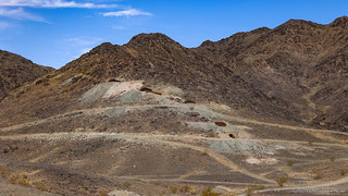
Now headed due east, I soon found myself in the undulating folds of Coon Hollow, clearly a place that's seen significant mining activity in the past, with claim stakes peppering the landscape and small diggings readily evident.

A few minutes after the timely text exchange, I arrived at the Opal Hill Mine. This - as the name suggests - is an opal mine (on a hill), and I was a little bummed in my pre-trip research to learn that while the opal was no longer sold commercially, it was still a mine where visitors had to pay a daily fee to wander around and search for opals.
To my surprise though - as I drove toward the mine - two ratty old cars alongside the entrance had been spray painted with the words "open dig." My curiosity piqued, I continued on.

Discovered in the 1890s, the story of the Opal Hill is a common one - a small amount of precious opal was discovered and claims were filed in the hopes that vast quantities of the material lay just below the surface. This never panned out, though the miners did find substantial amounts of fire agate. The mine changed hands several times over the years, eventually transitioning the mine to its rock-hound status nearly a century later!


After poking around for a bit and picking up a few small pieces of interesting looking agate to bring home to my resident rock-hound, I climbed back in the Tacoma to continue along my way. At this point I was trying to balance two desires - continuing to put miles behind me, so that I'd arrive at the Hauser Geode Beds as early in the morning as possible, so I wouldn't be digging around in the mid-day heat - and finding a spot to camp that would have a view of the eastern horizon - so I could stand a chance at enjoying one desert sunrise while I was on the trip.
Ultimately, I decided that I shouldn't rush - I was out here to enjoy myself, and seeing the sun come up over the horizon was part of that enjoyment.

It was 6:15pm when I found myself at Clapp Spring. A desert oasis like so many other springs, there was no water here, but a cluster of palm trees suggested that there was likely some just under the surface - and perhaps even above it at the right time of year!

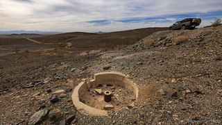
Not wanting to camp too close to the spring itself - in case desert wildlife should come by for a pool of water I hadn't discovered - I backtracked a good distance along the road so I'd have a view to the east, and set up camp near an old fire ring and what appeared to be the crumbling walls of a stone structure,
There, I ate a few potato chips and munched on an apple as the sun set to my west, its long rays playing across the landscape, turning the dry desert canvas into a thing of beauty.


After prepping camp once again for any wind that should pick up during the evening, I climbed into the tent just after 8:00pm with my hopes high that a similar breeze to the previous evening would keep me comfortable as I lay uncovered atop all my bedding. Certainly at 90°F, I was in no danger of getting cold.
I fell asleep almost immediately.
The Following Day...
I don't think it ever cooled down enough to get under the covers in the tent, but I still slept great out here in the middle of nowhere. In fact, as I arrived at the geode beds several hours later - to RVs and vans dotting the landscape - I realized that I'd really lucked in choosing to modify my plan the previous evening!


With camp put away before the sun had fully risen over the horizon, I hoped that my early departure and a bit of skinny pedal would mean an early enough arrival to the geode beds that it wouldn't yet be sweltering outside as I hunted around. Now rounding Thumb Peak - dramatically less prominent from this angle - I passed by Clapp Spring again before continuing on my way.


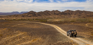
My route now wound through the Palo Verde Mountains. With no mines to explore - at least that I knew of - it was just a pleasant drive through remarkable terrain as I worked my way towards Wiley Well Road. I have to say that the geology here rivaled any that I'd seen so far on the trip, and the time of day - plus a little bit of cloud cover - helped to keep the temps very pleasant for this part of my journey.


Now just after 7:45am, I was making good time on my final side-trip of the Bradshaw Trail. I figured that it'd take me a couple hours to explore the Hauser Geode Beds - perhaps scooping up a treasure or two - and then I'd be on my way. First, of course, I had to get there!


The Tacoma made quick work of the dusty trails to the Black Hills - where the geode beds are sprinkled just about everywhere - and before long, I was winding my way towards their center, hoping that it would be obvious where I should dig.


Having found a spot to dig, I promptly decided that there would be no digging in my future. Sure, I could chalk it up to the rising temperatures, or the fact that I had a sum total of zero idea what I was doing - but the sad truth is that I'm lazy. Instead of digging, I set about collecting a few scraps left by those who came before me. You know, the ones who actually knew what they were up to.

All but two of the geodes I found ended up back on the ground - one small thunderegg for @mini.turbodb to crack open, and the most colorful specimen in the middle hauled back for @mrs.turbodb to have a peek at - as I washed up and continued on my way.
This is likely a good place to note that the BLM rules for rockhounding are as follows:
Rockhounding is one of many recreational activities on BLM lands in California. Rockhounds are welcome to collect small, noncommercial quantities of rocks, minerals, and gemstones free of charge on BLM lands. Commercial collecting for the purpose of sale or barter is not allowed without special authorization.
Only reasonable quantities are to be collected. Reasonable limits for personal use are defined as 25 pounds, plus one piece, per day, with an annual limit of 250 pounds.
Rockhounds may use hand tools such as shovels and picks but must not use explosives or power equipment for excavation.

As I continued through the geode beds, it was pretty entertaining to see where people had choosen to dig. Nothing seemed out of bounds - all ashy areas were pocked with holes. Some sections of road were even slightly hazardous to drive on, as rockhounds seemed to care more about finding that perfect crystal-lined sphere than being able to retrace their steps to camp!
Soon though, I was out of the thick of it and back onto the higher-speed, dusty roads that would return me to the Bradshaw Trail for my final push to La Paz. It was a good feeling, and my spirits were high as I knew that there were still a couple more mines to explore along the last few miles of the route.


The first mine I visited was the Roosevelt Gold Mine. I didn't expect much here - I could see that the site had been cleaned up in the satellite imagery - so I wasn't surprised when the end of the road was a simple, boring, gravel pad.

I didn't even get out of the truck at that point, opting instead to carry on to the final mine of the adventure - the Rainbow Gold Mine. This one had appeared to have a bit more going on when I'd scoped it out from the comfort of my computer chair, so it was with high hopes that I headed north into the flanks of the Mule Mountains a little before 9:30am.
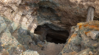
It turns out that most of what was at the Rainbow Mine were big metal grates over the various adits, all of the mining equipment and structures neatly cleaned up - either as part of a remediation effort by the mining company or as a safety precaution by the BLM. Still, one of the shafts was accessible, and I ventured in a few feet for a quick photo.

With that, all that was left were a few miles of trail between me an civilization. The Bradshaw Trail doesn't end here - and neither would I - but the remote part of the journey certainly does, as the route exits the Mule Mountains and descends into the Palo Verde Valley.

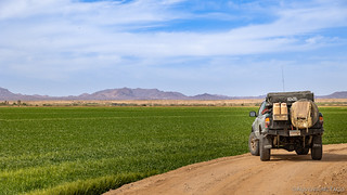
Palo Verde Valley - just west of the Colorado River - is one of the premier agricultural regions of California. With year-round warm temperatures, and plentiful water from the Colorado River for irrigation, every field in this region can support several crops per year, dramatically increasing the viability of a farm.


A few miles further into town, I reached the former site of the Adobe Stage Station, the final station before the end of the route in La Paz. Like much of the rest of the valley, a concerted effort by Thomas Henry Blythe to acquire as much land as possible - in this area under California's Swamp and Overflow Act of 1868 - for agricultural cultivation is likely what initially led to the clearing of trees from this area, and the development of gravity-fed canals from the Colorado River.
From the town now named for Blythe, I had 15 miles to cover to La Paz. More than a day-long journey by wagon, pavement and bridges have made things much easier, and within 15 minutes I found myself standing near what may have been the end of the line. Today, a Hualapai memorial stands in this place, honoring Native Americans who once worked at concentration camp in the late 1800s.


It'd been quite the journey. A bit more wash boardy and devoid of mining relics than I'd hoped, but still an enjoyable experience along a historic route through the west.
When establishing this route, Bradshaw decided that the surest way to profit was to run a ferry service over the Colorado River and shortly after completing the journey, he secured the exclusive rights to run such an operation for the next 20 years. Typically, Bradshaw delivered 30 to 50 passengers plus freight per day. With travelers describing the roadway as “lined with teams,” it's no wonder that Bradshaw experienced quite the rise in notoriety in his day.
| Ferry Service | Fee (in 1860) |
| One wagon & 2 draft animals | $4.00 |
| Additional team of 2 draft animals | $1.00 |
| Carriage with 1 draft animal | $3.00 |
| One beast of burden | $1.00 |
| One horse or mule with rider | $1.00 |
| One footman | $0.50 |
| Cattle & horses, per head | $0.50 |
| Sheep, goat or hog per head | $0.25 |
For me, the journey was only halfway done - I still had the 1,200 mile trek north before I could call myself done. And, like the travelers of the late 1890's, I too felt like I'd be spending a pretty penny on the journey. Still, it was a small price to pay for the adventure!

As I sat, watching the price creep up, a modern wagon train came rumbling by. This one - a full seven locomotives in the lead - was a great way to end my time in the desert.


 Bradshaw Trail #4")
Was the washboard any worse than the road to Eureka Dunes in DV?
Hey Greg - it was worse for me! I think a lot of it has to do with the spacing of the humps. In DV, I can get going about 40mph with a 1st gen Tacoma and the spacing of the bumps+speed evens everything out. Here on the Bradshaw Trail, I couldn't find a speed - between 10 and 50mph that would even everything out. Ack!
Another great (series of) reads! Thanks for sharing and continuing to inspire myself and others! Glad to see the new springs are holding up well for you.
Glad that you’re enjoying the stories Thomas!
FYI - that's not rice ... it's bermuda grass. They flood the fields from canals (river).
Wow, really? I had no idea that Bermuda grass was farmed, or that it could get several feet tall! What is it farmed for?
Hi turbodb, Great article. I've been busy reading them all and trying to decide what ones to reply to first. Bermuda grass is mostly grown commercially as hay or sod for golf courses and yards. A neighbor has Bermuda grass in her yard and during winter looks dead. Personally I wouldn't grow Bermuda grass as it's invasive and can cause allergies, awful for those who suffer from hay fever. Our hay of choice when I had horses was Timothy hay, coming from the mountain valleys of Colorado. When we rented pasture our landlord would consult Colorado State U for the best grasses to grow for hay.
I grow rocks in my yard.
Rice is too water hungry, not a good fit for the desert states. Same for alfalfa, I wouldn't feed that to my horse either.
Reply to all of them - I love to hear what folks think about any given story. Actually adds a lot of fun for me, and I'm always surprised by what I learn, or what folks find enjoyable! ?
As for the Bermuda grass - I've just never seen it flooded like rice when it's grown. That seems strange to me, which is why I assumed that I was looking at rice. My experience has been more similar to yours - lawns and golf courses.
Amazing to me how much rice, alfalfa, and hay is grown in California. But then, when you get water from so many surrounding states... Hopefully some day, logic kicks in and we start conserving it a bit more in the places that are naturally deserts.
And thank goodness for all the rain/snow so far this year!