
For a couple of years now - ever since I read a trip report from Mike @mk5 - I've wanted to drive the Bradshaw Trail. Located in the southern California region of the Sonoran Desert, it traverses some 85 miles of desert - from the Salton Sea to the Colorado River and the La Paz region of Arizona. When I recently caught up with Mike as I was Hiking Saline Valley, he surprised me with his own personal copy of the Gold Road to La Paz, an Interpretive Guide to the Bradshaw Trail.

The Bradshaw Trail itself though, isn't the highlight of and adventure like this. The road itself purposefully follows the most boring route through the desert possible - after all, if you were doing this in a wagon train, low effort would be your goal too! Rather, much like the Mojave Road a hundred miles north, a series of side roads and attractions provide the intrigue and adventure on this trip. There, mosaics of colorful geology, blooming cactus, and historical sites abound. And then there is the solitude - this area seemed even more remote than Death Valley or the far reaches of the Mojave Preserve. For the desert lover, there is certainly plenty to get excited about!
Having left earlier than usual, I arrived at the Salton Sea a little before 10:00pm, and quickly found a place to setup the tent and climb into bed. Temps were nice - in the mid-40s °F, and I got a fabulous full night of sleep.


With temperatures warming up by the second, I put the tent away as quickly as I could and ate breakfast. Unfortunately, I'd forgotten the actual cereal for my cereal, so it was a bowl of blueberries and milk, every day of this trip!

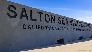
I still had a few miles from my camp site to the Bradshaw Trail, and with the Salton Sea Visitor Center halfway between, I decided a quick stop was in order - even if it was still too early to be open - just to make my way to the sea's edge and check out this crazy body of water.
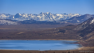
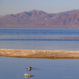
At 35 long and 15 miles wide, the Salton Sea - which is 200 feet below sea level - is the largest lake in California. With nowhere to drain, the current sea was created in 1905 when irrigation canals burst and for two years, water from the Colorado River flowed into the valley. Today, runoff from agriculture continues to be the main source of water for the sea, which loses water only to evaporation. This combination has resulted in the water becoming more than twice as salty as the Ocean, killing the vast majority of the aquatic life that once lived within its banks.


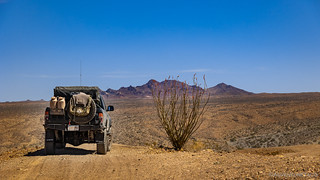
I didn't spend long at the edge of this vast lake, anticipation of my desert adventure too great to dawdle. Soon enough, I was headed east, where I'd air down for the duration of the entire journey along the Bradshaw Trail, as well as several side trips!


The first few miles of trail wind along next to the Coachella Canal, to a palm tree oasis that was once the site of the Dos Palmas Stagecoach Station. At the time, only two palms grew here, where today there are hundreds.


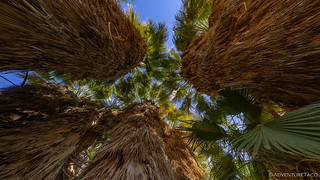
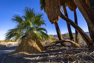
In recent years, the site of the old Dos Palmas station was used as for agricultural purposes - like much of the rest of the valley - hundreds of small pools now all that's left of an old fish and shrimp farm.

Even wandering around in the shade of the palms at 8:56am, I was starting to sweat. Temperatures were forecast to be in the low triple-digits for my entire journey, figuring that I'd be much more comfortable in the air-conditioned cab of the Tacoma, I headed that direction to get back on the trail.
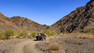
Already - and for much of the remainder of the trail - I found myself travelling over one of the most deeply wash boarded roads I've ever travelled. It was the kind of washboard where no speed was really fast enough to smooth out the bumps, both my truck and bones feeling as though they would rattle themselves apart if pushed too hard. It was a little frustrating actually, as for me, 250 miles of washboard made what a trail I'd really been looking forward to, a little less enjoyable.
Luckily, side trips were (a bit) better - though UTVs had worked their destructive magic on them to an extent as well - and my first was only a couple miles up the road to an unnamed mine working on the southern flanks of the Orocopia Mountains.

Not knowing that most of the mining sites I'd visit along the way would be in similar condition, I was still in high spirits as I bumped and clanked back down to the Bradshaw Trail. I knew I had a decision to make - continue on to the Eagle Mountain Rail Trestle, a landmark I'd been looking forward to - or make a loop up through the Orcopia Mountains and a visit to Gucci Spring. Knowing that I'd eventually make it to the trestle, I opted to give the loop a go first.
For those interested in this loop, the Gold Road to La Paz guidebook noted that it is closed to all vehicular traffic between June 1 and November 1 to avoid possible harm to a heard of Nelson bighorn sheep that cross the area in search of water every year.
I should note that I believe the guidebook may be out of date. While there was no signage indicating wilderness at the beginning of the loop I took, and tire tracks the entire way, there was a sign - and barb wire fence - when I arrived at the opposite end of the loop near Gucci Spring. While I found a way through, I believe that this area may now be wilderness and should be hiked rather than driven at all times of the year.
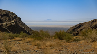
Climbing the alluvial fan, I soon found myself meandering into a wide canyon, the walls rising into the bright blue sky, and the views behind me stretching for over 50 hazy miles.

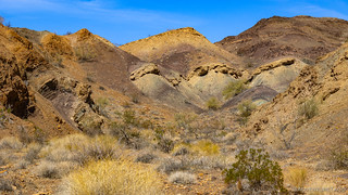
Before long, I was headed up a side was of the main canyon, and the geography really got interesting. Narrow passages, tight turns, and colorful hillsides unfolded before me, each turn heightening my curiosity for what it would hold. Despite the warmer and warmer temperatures, I found myself constantly exiting the Tacoma to snap photos and hike portions of the trail, just to experienced them on foot.


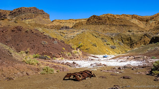
As I wound my way through washes - there were several places where the geology really jumped out for one reason or another, and clear indications that explorers had been visiting these places for many years.


Eventually, I reached the trailhead for Gucci Spring. Amazed that there could be a spring in this area - but reminding myself of the amount of water at Dos Palmas - I set off on the mile-long hike to the spring. This was the most enjoyable segment of the loop for me, as I've found that the experience when hiking is much more immersive than driving. I don't know if it's the slower pace, the smells, or simply the ground under foot; whatever it is, it is bliss.


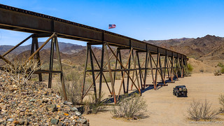
By the time I finished up at Gucci Spring and made my way back to the Bradshaw Trail, it was just a little before noon. It was hot. And I was glad to be at the Eagle Mountain Rail Trestle, where at least there was a bit of shade.
Built in 1947-1948 to haul iron ore from the Eagle Mountain mine down to what was then the Southern Pacific transcontinental mainline, Eagle Mountain Railroad was one of the longest new rail construction projects of the century. It crossed a number of washes with wooden bridges and cast-iron culverts, the longest of which was this 500-foot-long steel beauty at Salt Creek Wash.
At its peak, from the 1950s through 1970s, two fully-loaded 100-car ore trains departed from the Eagle Mountain Mine each day, ferrying their loads to the Southern Pacific at Ferrum Junction.
Eagle Mountain Mine closed down in 1984 and the last commercial train ran on March 24, 1986.


After a bit of poking around and procrastinating the pure torture I knew was ahead, I climbed back into the Tacoma to resume my bouncy-jouncy ride along the washboard of the Bradshaw Trail, now tracing its way up the Salt Creek Wash. I was starting to get hungry at this point, and figured that my next side trip - to Canyon Spring, the site of an old stage station - might be a good spot to have lunch.


Back in the day, there was - apparently - a mill approximately half a mile up the canyon on a large shelf above the wash. While the mill was removed - and repurposed elsewhere - the foundation walls were still visible on the shelf. As I searched for them, a trio of F-35s raced overhead and I snapped as many photos as I could.

I hadn't really been expecting to see any jets on this trip, so you can imagine my excitement with three low-flying F-35s. I shouldn't have been surprised, really, since just south of the Bradshaw Trail is the Chocolate Mountain Aerial Gunnery Range, and the Gold Road to La Paz warns dozens of times, not to take roads that lead south! Still, seeing the planes put me on alert for the remainder of the trip - a fact I'd be thankful for later.
Leaving Canyon Spring, lunch was at the top of my mind. I hadn't found a great place to eat it, but I hoped that perhaps the narrow washes of Red Canyon - and its next door neighbor, Pinnacle Canyon - the entrance to which was just a mile up the trail, might provide a place to part the Tacoma in the shade and assemble a lunch that could offset the meager breakfast I'd consumed nearly six hours earlier.

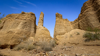


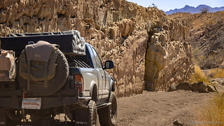
I wasted no time in setting up the kitchen to prepare tacorittos. Even in the shade it was over 90°F, and I quickly cooked and consumed the beef-rice-guac-cheese-lettuce-and-tortilla meal in order to retreat to the air conditioned comfort of the cab. Only half-way through the Red Canyon loop at this point, I was soon navigating my way through one of the few places that a vehicle can climb out of the canyon bottom and onto the ridgelines above.

When I reached the ridgelines, the views were spectacular. To the north, the gentle fingers of the Orocopias spread out to the east and west. To the south, views over the Salton sea. And, along the trail, ocotillo cactus, many of them in full bloom!


Soon, my side trip was complete, and I was back on the trail. For the final two miles of the Salt Creek portion of the Bradshaw Trail, I'd travel the old rail grade, its solid base a welcome change to the soft wash-boarded trail that'd led me - to this point - over the alluvial fan and through the Salt Creek Wash.


A mile later, as the rail grade continued north and the Bradshaw Trail turned towards the east, I put the first segment of the trail behind me. Except for the washboard, and the fact that the historical sites I'd hoped to see have been largely lost to time, I had to admit that the scenery was extremely nice.
And, while I hoped that the next section - Across the Chuckwalla Bench - would be a little smoother and offer a little more in the way of relics, I had no idea the excitement I was in for. Not to mention the place I found myself as the sun set, and the spirits of old mines began to roam the land.
.


 Bradshaw Trail #4")
I have followed the Bradshaw Trail not sure if it's something that my 2-wheel drive Ram 1500 could handle, it has good ground clearance and from your description of the Trail I'm guessing the truck could make it. But will probably wait until fall for the drive. In the meantime plan to spend time closer to home in Red Rock Cyn and other areas along Hwy 395. I see you use my favorite water bottles. I have a bunch of them for bike rides.
You'll have no problem at all on the Bradshaw Trail John, the Ram 1500 will do just fine. A couple of the side trips that I did later in this trip might be a little tight, but for the most part, the road and ground in the area is firm and the trails are easily handled with a full-size vehicle. You'll probably find that airing down a bit will give better traction (especially with 2WD), as well as a mor comfortable ride.
As for the Camelbak Podium water bottles - those things are great! I've even got a little fanny pack thing (which they don't make anymore, but is a bit like the Podium Flow if it had a second bottle) that I can carry two of them and an extra camera lens in when I go on hikes. Love it!
Yes, the loop is now wilderness and closed to vehicles. There was a barbed wire fence across the wash on the west end. More desert closed to motorized access. Accessing the start of the trail is now complicated by gates along the canals as well. From my research anything south of the Coachella Canal is pretty much off limits. The roads are mostly on private land and around 8 years ago,, when I was leading groups,, the threat of meeting up with Imperial County Sheriffs was real. The book, while a good source of info, is very out of date as to access.
So Tim, I have to ask... any relation to Augustine Pass? I assume not and it's just a coincidence, but if there is one, that'd be pretty cool.
For the trail - that fence you mention, which for me was on the east end of the loop, was what clued me in to the fact that it might be wilderness now. As for south of the Coachella Canal, I didn't run into any big problems with gates (except for one just east of Dos Palmas), and there seem to be a huge plethora of trails there, so maybe things are different today than 8 years ago. South of the Bradshaw Trail though - into the Gunnery Range - that was definitely heavily signed as off limits. I guess that's not really that far south of the canal, so maybe that's what you're referring to...
Would love to hear about any cool places you've found in the area - I'm always looking for new trip destinations. ?
There is no relation to the Augustine of Augustine Pass that I know of. Purely coincidence. My father's family came to Socal after WWII, I believe, and there were no Martin's.
I went back to my track files and discovered that my first prerun was in January of 2008, and the group run was in April, I think. Thereafter, I ran it every other year until 2014 or 15. I ran the loop you did, but there was a fence across a broad wash on the west end, that I later found was the wilderness boundary. I never ran it again once I knew. The fence may have washed away by now.
There were a series of posts at the time, I believe, in Expedition Portal concerning access around the canal and the south side. The author recounted his encounters with ICSO and the, I believe, Imperial Water District, who manages the canal. Rather than risk a run-in with law enforcement, I took his suggestion and re-routed north over the canal at a crossover west of Desert Aire Dr., then east along the powerline road until it intersects with the canal and the old, out of service canal just north of the current one. Then we used the old canal road on the north side to eventually meet up with the Bradshaw where the canal turns south. That seems to be the legal and approved route.
As for cool places, there are many old ones, but a lot have been erased over the years, as you found. A great resource I found, was the old Desert Magazine, started in 1937, I think. There are many cool articles about desert places and travelers and current events of the time that are now history, like the building of the Colorado River Aquaduct, and the tunnels through the mountains for it. Many interconnected pieces relating to the iron mine.
I have all of the issues from the beginning to the end in the 1970s or 80s in pdf files on a flash drive. Email me directly if you want to discuss further.