
Nestled into the mouth of an unnamed canyon of the eastern Inyo Mountains, sleep came quickly after climbing into the tent a little after 8:00pm. For five hours, everything was great - temperatures were perfect, in the low 40s °F, a gentle breeze cascaded down the canyon, and clear skies eliminated any anxiety about putting the tent away wet in the morning.
Then, as if to remind us that conditions should never be taken for granted in the desert, the wind picked up. As though a switch had been flipped, gusts up to 40mph seemed to appear out of nowhere. Nearly folding the tent in half with us inside, I scolded myself for not weighing down the ladder with a 5-gallon jerry can of fuel. As I climbed down the ladder to take care of it at 2:00am, it was another reminder that slower is faster - the adage I first heard from Eric @RelentlessFab several years ago.

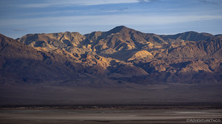
By the time the sun as peeking into the canyon, the winds had died down again. It was shaping up to be another beautiful day in Death Valley. Or, I technically, immediately west of it.

Not so sheltered as we'd thought.
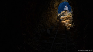
Having walked right past the Blue Monster Mine when we'd arrived the previous evening - an optimization I'd proposed given our limited light - we'd camped less than 500 feet down wash from the lower terminal of the aerial tramway and mill site, allowing for easy access this morning.
This mine was known for decades as the Monster Mine, perhaps because of the unusual size of its original lode: a vein of solid galena over 3 feet wide and 40 feet long worth $100 per ton!
Quartz veins also contained a little pyrite, cerussite, tetrahedrite, chrysocolla, linarite, and caledonite. From the mine high up the canyon wall, the ore was trammed down to the mill, then processed, packed over the Inyos to Mazourka Canyon, and teamed to the railroad in Owens Valley.
Most of the galena had been removed by 1911, just four years after its discovery. Since 1912 - except for short-lived exploitations - the property has been mostly idle. The only recorded production was in 1935, when 50 tons were shipped to a smelter in Utah. It was around then that "Blue" was appended to the mine's name, perhaps following the discovery of copper.Hiking Western Death Valley National Park

The mill that once sat atop the concrete footings is no longer present, but the tramway terminal and ore bins still line the side of the wash.

An early attempt at the modern turnbuckle.

This seemed a little out of place, but perhaps not given the mine was active in the early 1900s.
Less than a quarter mile farther up canyon, a foot trail climbs 700-feet to the upper tram and workings for the Blue Monster Mine. As always, I'm a sucker for the aerial tramways, so there was no question that we had a bit of climbing to do.
Having left about 15 minutes before @mrs.turbodb, I left Hansel-and-Grettle-style sagebrush arrows on the ground for her to follow, just to make sure that we both ended up in the same location. Ironically, in a cruel twist of fate, @mrs.turbodb reached the top 10 minutes before I did when my initial trail choice resulted in a dead end at the edge of a ravine, the entire side of the hill having slipped into the wash!

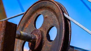
The upper anchor and brake for the aerial tramway.

The braking system used blocks of wood wrapped in canvas to slow the rotation of the pullies.
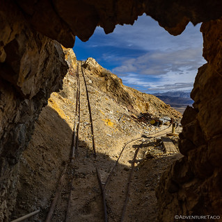
Once I'd clambered my way up the mountain to rejoin the - more intelligent - hiker who'd headed straight to the top, it was time to check out the rest of the mining operation. An old generator and rail line sat outside the main tunnel, and a narrow trail lead higher up the hillside to what appeared to be an open-pit operation.

From the open pit, the view down to the primary adit and out into Saline Valley would have been a nice place to come to work every day... if the work didn't involve wandering into a hole blasted in unstable rock.
I'll stay out here, thanks. 

Anyone need a size 24 battery? Sears quality, only 90 years young!

Colorful ore, indicative of the small amounts of copper found in the later years.
Knowing that we had a full day ahead, and already having spent longer - entirely due to my bumbling along the wrong path - than we'd planned at the Blue Monster, we headed back down to the Tacoma and quickly packed away our belongings before heading back towards Saline Valley.

There really is a trail there somewhere.

Glancing back at a canyon we'd explored the previous day.
Back on the main road - technically Waucoba I suppose, but one that I always think of as being Saline Valley Road - our next stop wasn't at a canyon or mine but, rather, at one of the few places in Saline Valley where civilization maintains a reasonably constant toehold - Willow Creek Camp.
While seeking out civilization may seem out of character, our goal here was noble: the next mine we planned to explore was on private property, and a note from Digonnet implored us to "Please obtain permission from the caretaker at Willow Creek Camp before coming here."

We've never run into this truck when it was in good shape (our first encounter), but it's certainly not getting any better.

I've found that whenever possible, speaking to locals - be it to ask permission or to glean knowledge/insights they have about an area - is extremely rewarding. Most people are more than happy to chat with those who show genuine interest and respect, and more than once I've left such an encounter with a tidbit that pays dividends for years to come.
From Willow Creek, it was less than a mile to the talc mine we planned to explore. One of several talc mines overlooking Saline Valley from the foothills of the Inyo Mountains, I'd noticed what appeared to be an aerial tramway when I'd been researching this trip.
Yeah, sorry, another tramway.
At any rate, there were two roads to this mine: one that terminated at a mile-long foot path which climbed 750 feet to the workings; another that accessed the lower terminal and ore bin. After a quick discussion, we - unsurprisingly and at my urging - opted for the hike, and soon we were climbing a well-defined foot trail as it switch-backed up the hillside.

As we approached the base of the Inyos, we both wondered... "where's the trail again?"

Up we go, the switchbacks tight and the views alright!
Given the position of the trail and topology of the landscape, none of the mine is visible until rounding a final ridgeline and descending 20-feet to the upper terminal. Still, there's plenty to keep a hiker busy on the way up - views of Saline Valley and the Last Chance Range compete for attention as they extend into the distance.

Rounding the ridgeline, the upper terminal of the aerial tramway stands at attention overlooking the valley.

The upper pulley of the aerial tramway. Seems... legit?
Winch line pulley.
Making our way down to the terminal, it took several minutes to work out exactly what was going on. The tramway - it seems - wasn't used to move ore at all. Rather - given the roadless nature of this site - it was used to move equipment and supplies to-and-from the valley floor. Ore - rather than being lowered in bins - was funneled into a medium-diameter pipe that ultimately emptied into a large ore bin 750-feet below.

The ore chute (foreground) funneled talc into the 12-inch diameter pipe, sending it cascading down the hillside. My super-scientific experiment showed this trip to take approximately 72 seconds for a baseball-sized chunk of talc. And it wasn't quiet.
The tramway wasn't the only interesting element of this mine site, and for the next 30 minutes we poked around the various trails, platforms, and adits, calling to each other as we found interesting details scattered about.

One of the powerhouses that was the lifeblood for this operation.

Plenty of this stuff around.

In one of the adits, a large bag of dynamite blasting tubes - filled with explosives before being inserted into pneumatically drilled holes and detonated - was enough to keep @mrs.turbodb at a safe distance.

Sometimes you just need a vise.


These "smooth operators" were key in such a dusty environment.

Only the main adit was sealed - likely as a liability precaution given the few pesky wanderers who find this place.
Of course, the most interesting element of all was the extensive rail system was used to move ore from the various adits to downhill transportation apparatus.

I feel that every historic rail line should have included curves in the track; they add so much visual interest for photographers.
Unlike most rail lines I've seen - which tend to be reasonably flat - there was a significant uphill grade from the main adit to the dump site. This obviously posed a problem for the miners - a several-hundred-pound ore cart full of talc would be impossible (for even a group of men) to push - but they came up with an ingenious pulley system to winch the cart uphill.

Looking down - and back up - the track to the main adit.

Looking up the line, it was interesting to see that they'd blasted a path to decrease the grade, and there was something interesting at the top.

The pulley - to keep the winch line from being abraded by the terrain - and winch used to move carts.
It was almost noon when @mrs.turbodb finally pulled me away from what would end up being our favorite mine of the trip. Both of us were hungry and decided that a reasonable plan of action would be to hop in the Tacoma for the short drive to the bottom terminal of the mine where I could snap a few photos while sandwiches were assembled.

Down we go.

A few minutes later...
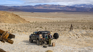
Desert kitchen.
Not knowing what we'd find at the top, I'd originally thought that the bottom of this mine was going to be more interesting. In fact, I'd said as much to my co-pilot when we'd discussed which approach to take first - or perhaps at all - which could have resulted in us skipping the upper workings entirely! Obviously, the exact opposite turned out to be true, but I still had a good time looking around the few artifacts spread around the site, working out their function and relation to the rest of the mine.

The bottom of the pipe that carried ore from high above, the final 50 feet rather modern.

From here, you can just see the upper tramway; the rest of the mine camouflaged from below.

It was this cart for the aerial tramway that confirmed our opinion on the fact that it was used to move equipment rather than ore.

Once pulled from the top, the tram most recently seemed to be operated from below by this Skagit Steel & Iron Works winch built in the 1950s.

Gear reduction.
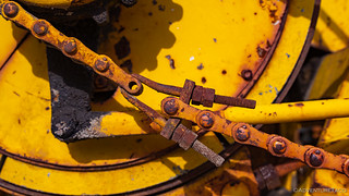
One way to repair a drive chain.
Talc mine exploration complete, it was time for an entirely different foray into the Inyo Mountains. So far - on this trip - we'd climbed up their sides and wandered their wide valleys, but it'd always been in search of human paraphernalia. Now, we'd do the polar opposite - hiking a deep gorge along a lively creek to witness something seldom seen in these parts: two cascading waterfalls that tumbled through sweeping walls of fern. We were headed to McElvoy Canyon.
Update (Feb 7, 2026):
McElvoy has experienced multiple massive changes in the past decade or so.
There was an absolutely monster landslide and debris flow in the early teens. The canyon wall just above the first fall had collapsed and created a dam that trapped a huge debris flow that had originated up canyon somewhere. As a result the mid canyon above the fall was completely filled with mud and downed trees - a wide flat wasteland of probably 20 to 30 feet of fill above the previous canyon bottom that stretched for at least half a mile. Absolute apocalypse and I think may have completely buried some of the upper falls. But you could get up above the first fall easily for the first time in a while as it was partially buried. Much of the hanging garden below the first fall had survived but it wasn't so much "hanging" any more as the fill meant you could stand right next to it.
Then the canyon experienced at least two major flooding events that completely scoured all of that out. The debris previously trapped above the upper fall washed all the way across Saline Valley Road. This was an unimaginable flash flood, there were tree trunks to the east of Saline Valley Road. The lower canyon was scoured to bare rock and the first fall now towered above the canyon bottom making the upper canyon totally inaccessible (at least to the likes of me). The hanging garden was once again hanging and there was no way to reach the plants that just two years prior I had stood right next to.
Digonnet's write up I think predates all this activity. The canyon is nothing at all like it was prior to about 2010 and has probably been at least three completely different canyons in the intervening years.Ken @DVExile

Impressive or intimidating? A little of both, I suppose.
The hike into McElvoy Canyon begins - as do most hikes in this region - by following a wash on the alluvial fan. Draining the extremely steep eastern slope of Mount Inyo - just west of Saline Valley's main sand dunes - water rushing east has carved a deep channel into the fanglomerate, making the actual entrance to the canyon a little ambiguous for those of us shorter than about 75 feet tall.

Never mind those multi-ton boulders hanging precariously overhead.

A colorful specimen.
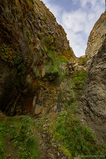
Much deeper than it is wide, the entrance to the lower canyon - a slot in the hillsides hemmed in by sheer walls of hard granite over 160 million years old - is imposing. We found it impossible to move more than a few feet at a time, our eyes repeatedly wandering up the walls, our mouths agape at the scale. This was a unique place, something special in this magical land.

As we reached the mouth of the canyon, we got our final peek at the valley below.

There was only one direction to look - up!
As if the visual stimulation of wasn't enough, the sound of rushing water echoed down the canyon. So unexpected is this sound in the desert that it didn't even register as out of place. But then, realizing that the falls - which we'd both given only a 50% chance of having actual water flowing over them, most of it seeming to have dried up in California over the last couple of decades - were flowing, excitement filled our conversation as we continued on.

Our first glimpse at the green, fern-covered wall of water (left), and the top of a 60-foot plunge (right).

Below the falls, a blanket of maidenhair ferns enveloped the canyon floor.
Not only was water cascading over the canyon wall high above, but a spring farther up canyon fed a constant flow of water running below the fall and making continued progress on the trail tricky.
Tricky that is, until I noticed an old rope. Covered in algae and soaking wet, it was a prime example of the type of rope that you should never trust your life to in the desert, the elements sure to have compromised its integrity. It was, however, our only path forward.

In this case, a fall would be muddy, but that was about all.
Above the first fall, this already magical place became even more so. As the trail became steeper and the towering granite canyon walls more imposing we wound our way around the tight bends of the canyon, the sound of running water filling our ears. As we bushwacked through willows and hopped over fields of boulders the size of small cars, we couldn't help but wonder how much longer this experience would last.

Light and shadows playing on the canyon walls.

Spilling over a house-sized chunk of granite, the creek cascaded down a polished chute.
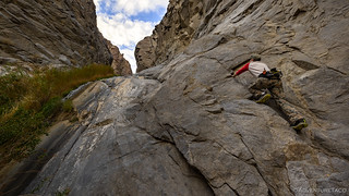
Eventually - as we knew it would - we ran into an obstacle that there was no way around. A 50-foot fall - polished smooth and slick with algae - blocked our way. A route along the right side of the falls seemed the most promising - others having obviously thought the same as there were two bolts and a piton anchored into the stone - but without a rope and climbing equipment, all we could do was fake it.
Silly boy.
Still, as we turned around to make our way back down the canyon, our minds and conversation focused on the two hours of success that we'd had as we'd enjoyed this fantastical place. So unexpected in this generally dry terrain, it was a refreshing interruption of the status quo.

Heading back, the views of Saline Valley strained to be seen between the hairpin bends of the canyon.

A mushroom? In the desert?
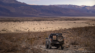
By the time we reached the Tacoma it was 4:00pm. With less than half-an-hour till sunset and not knowing what to expect from the weather overnight, we decided that the prudent move would be to find a sheltered spot to call home for the evening. As we retraced our path to Saline Valley Road - the Saline Valley Dunes filling our view - the only question was, which of the two remaining canyons we planned to explore would be the best candidate? We didn't have time to check them both.
One of the few dunes I've not had the pleasure of hiking in Death Valley National Park.
Across the valley, the sun danced in the folds of the Last Chance Range.

Local riff raff.
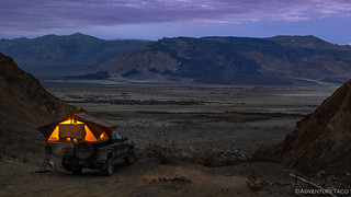
Ultimately, we made the decision to head up to the mouth of the southernmost canyon to the ████ Mill site. This wasn't a decision we made based on topography or any intelligent analysis of the terrain; rather, our thinking was that - given the historically developed nature of the location - it would provide some level ground, and would allow us to explore the site in the morning without having to tear down camp beforehand.
Win. Win. If it wasn't too win-dy overnight.

Hopefully, our home for the night.

As we climbed the alluvial fan, an old dump truck stood guard along the side of the road, just beyond the wide mouth of the canyon.

How many times have we driven within a few miles of this place, completely unaware of its existence?

We pulled into camp just as the final rays of sun were kissing the snow-dusted peaks of the Inyo Mountains to our south.
It had been another full - and fantastic - day. As we set about setting up, we reflected on how similar our route - so far - seemed to the route we'd taken along the east side of Panamint Valley, as we'd followed the Nadeau Trail. There too we'd repeatedly turned up the alluvial fans - into the Argus Range - to investigate canyons and mines hidden in the hillsides.
With the sun set and the camp lights on, dinner was a familiar affair - Taco-rittos with plentiful guacamole - as we looked out over the valley that we'd skirted the eastern edge over the last two days.
We'd seen no one as we'd travelled the Nadeau Trail, and after two days of solitude on this similar route, I found myself wondering if - for only the second time in 17 visits to the park - we'd achieve the same along the base of the Inyos.
Looking back now, the approaching weather - which we'd get our first taste of overnight - may have been a contributing factor...


Another wonderful and satisfying adventure, thanks for sharing. The beauty of these outings (I learned from decades of hiking and backpacking) is discovering things you never knew were there! Of course these days with satellites, photos, etc., more planning can be done beforehand but there are still surprises to be found as you demonstrate!
Isn't that discovery of the unknown "the best?" You really hit the nail on the head with that, and it's one of the most enjoyable parts of any trip for me. On a recent trip (that I just returned from yesterday), I got to meet someone else who's interested in exploring all these places, and he mentioned a Death Valley resource library to me that is generally available to the public, but that not many people know about (I certainly didn't). It was another of those things that I'd not expected, but am now looking forward to - at some point in the future - diving into, just to learn more about some of these fantastic places!
I know there is an online library and several libraries in and around the Death Valley area. The one in Ridgecrest is supposed to be good but haven't been over that way yet.
Why do guys like us find beauty in a bunch of junk in the desert? That picture of the vise is too much. I can just see some big old miner banging away on it with a 5lb. sledge, while the sun comes up /or goes down in those mountains below.
Junk?!?! OK, yeah, you're right, it probably is *technically* junk.
For me, the bit that makes it so compelling is exactly what you're touching on - the history that brought it to be there, and how it is just a small part of a larger story of the place; usually a much harder place than the world in which we all live today. One of my favorite photos in this regard is one that I got at another Death Valley Mine: the Whitecap Talc Mine. That tricycle brought so many emotions and thoughts rushing to mind for me. Just imagining a kid in this environment, trying to stay entertained; a father trying to make the situation bearable for his son (or daughter) - stories we'll never really know the answer to, but which make the places that much more special.
Look at he way that pedestal is mounted to the base. That thing will be there for century's. The bicycle picture is one of my fav's also.
Great job guys! Dang, if I only really knew what I was driving past all these times, focused on keeping the speed up on that washboard road. Gotta change my ways and open my eyes! As for those night winds... I've got stories!
--Paul