")
For years we've travelled south to explore the Mojave. More times that I can count, we've cruised south - and north again - along US-395 through the Owens Valley, or followed US-95 through Nevada. On every one of these, we've passed by the White Mountains, their sharp peaks - often dusted in snow - reaching high into the sky.
And yet, even as we've stopped to explore areas near these mountains, we've never taken the time to wander into them.
This trip would change all of that. With several days to explore, we hoped that our timing - at the tail end of spring - would allow us to summit our first 14-er in snowless-but-not-hot conditions. That we'd be able to immerse ourselves amongst the Bristlecone; the oldest organisms on the planet. That we'd be able to soak in Sierra views.
That we'd finally discover what we've been missing, as we wander the White Mountains.
 Two Too Hot Hikes | White Mountains #1 - For years we've travelled south to explore the Mojave. More times that I can count, we've cruised south - and north again - along US-395 through the Owens Valley or followed US-95 through Nevada. On every one of these, we've passed by the White Mountains, their sharp peaks - often dusted in snow - reaching high into the sky. And yet, even as we've stopped to explore areas near these mountains, we've never taken the time to wander into them. This trip would change all of that. We'd finally discover what we'd been missing, as we wandered the White Mountains.…
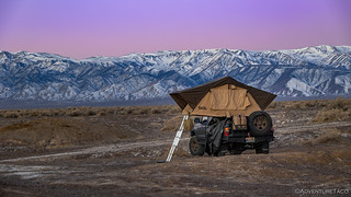
 Ancient Bristlecones and the Oldest Tree on Earth | White Mountains #2 - There's a reason they don't tell you where the oldest trees are. Having completed two very hot hikes, we hoped that by gaining a bit of elevation, we would find somewhere a little cool(er) to eat our hot dogs and corn before quickly getting horizontal on our Exped Megamat to fall asleep. To do this, Silver Canyon seemed to be the quickest way to climb from somewhere around 4,500 feet in Owens Valley, to more than 10,000 feet along the ridge of the White Mountains, so that's the direction we headed. Hmm, I thought this was going to be a…
 Our First 14er | White Mountains #3 - Unsure of the tenability of the main hike we'd planned for our visit to the White Mountains - a hike to the 14,252 foot summit of White Mountain itself - we proceeded toward the trailhead with a bit of trepidation. A few minutes earlier, we'd been approached by a Spanish-speaking couple who'd asked @mrs.turbodb if we'd been to the end of the road. They'd picked us because our vehicle suggested that we might have been, and the information officers - at the Ancient Bristlecone Pine Visitor Center - told them that they wouldn't be able to make it because the…
 Secrets of Crooked Creek | White Mountains #4 - Somehow, we'd completed a 16 mile hike to 14,252 feet above sea level in just under nine hours. Figuring that it'd take more than a little longer - especially after eating lunch and hanging out at the top for a while - I'd planned for us to spend a second night at the White Mountain trailhead. Then, we'd spend our final day of exploration winding our way through a few canyons and meadows that I'd heard were well worth visiting. But now, we had options. It was time to work out how to best squander them! Working our way down…
Have you made this one happen yet?
Nope. Slated for a couple weeks from now, in June!
Well then. Do you know about the Champion Spark Plug Mine?
On the list, along with the Sacramento mine, and a run into Crooked Creek/Dead Horse Meadow from Wyman Canyon.
Sounds like it will be a great outing.
I last attempted to visit the Champion mine in November, 2021 and found that the road into the canyon was completely washed out. I was in my lifted early Bronco on 35's, ARBs front and rear etc and there was no way. Hopefully it's been re-opened because it's a long hike otherwise. If it's open, the shelf road to the upper trailhead is a little dodgy but it shortens the hike considerably.
Lastly you probably know this but the area, especially on the west side of US 6, is loaded with rock art and obsidian knapping sites.
Fingers crossed on the road. How close to pavement were you stopped? We were planning on something like 2 miles to the camp and another 1.5 to the workings, making for a 7-mile roundtrip.
And yep, the Volcanic Tablelands are amazing from an art/artifact perspective. I've done a few trips to visit them, and some have gone better than others, lol.
Since I typed that I did a search and found a couple of links with posts indicating that the road has been improved since I was there.
I would share a Google Maps link showing how far we made it but I'm guessing this comment format won't allow links (and yes I understand why). Using Google Maps in satellite view, if you zoom in on the road where it enters the canyon, "Jeffrey Mine Canyon" will appear in green text. A stream can be seen crossing the road just to the left (west) of the text. That's how far we made it, and we were on foot- hiked most of the way from the north-south road that forms the eastern boundary of the developed area to the west. And also I believe that even though Google Maps shows that north-south road as being part of the route, the actual north-south road has been shifted slightly to the east due to private property concerns.
As an aside I consider myself pretty much a whiz at using Google Maps to find stuff, but I had a helluva time IDing the mine camp itself even though I've been there. I was able to locate the track leading up to the high trailhead and its parking area. The trail itself is barely visible and you kinda need to know where to look.
All that said, you are clearly in good shape and I encourage you to do what it takes to get up there. So worth it.