
Previously, you may recall...
It was just before 1:00pm when I arrived back at the truck, and I had a decision to make: the day's plan called for another ~8.5 mile loop hike high into the Last Chance Mountains, but I wasn't sure I'd have enough time before the sun went down. My options - perhaps obviously - were to try for the full hike, skip it altogether, or cut the hike in half by making it an out-and-back rather than a loop.
Ultimately I knew there was no way I'd be happy with myself if I skipped it altogether, and I realized that I could defer the decision of loop vs. out-and-back until I reached the turnaround point, so I stowed the now-dry tent and jumped in the truck for my 2 mile drive to the next "trailhead."

I didn't make it far - less than a mile - before running into something I see all too often out in the desert. In fact, I think I've retrieved at least one of these from Death Valley, the Mojave Preserve, and Anza-Borrego every time I've visited. This trip, I ended up with three.

Mylar birthday balloon stowed where it belongs - in the Trasharoo - I popped back in the truck for the final approach to my next "trailhead." My lengthy excursion  had covered the entire length of Dry Well Road, where I parked just before the intersection with Eureka Valley Road and set off up the alluvial fan into the Last Chance Mountains.

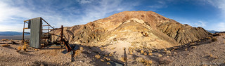
My loop would take me along an old abandoned mining road high into the Last Chance Range. Along my way, I'd pass through the narrows of a wash and badlands of black shale. I'd find the Last Chance Mine and it's surreal mercury retorts - some of the most interesting mining remains in the valley - and then, I'd skirt along a high ridge past two other mercury mines with breathtaking views of Eureka Valley.
At least, that was the promise made by Hiking Western Death Valley National Park, and it sure caught my attention and piqued my curiosity.
Unlike my leisurely pace in the morning, the fact that I had only four hours of daylight pushed my pace faster in the afternoon, and I made good time up the much steeper fan on the east side of the valley. The truck - standing guard at the trailhead - shrank quickly in the distance, the landscape behind it somehow familiar.

While there had been no road or path up the alluvial fan, as I approached the first knoll, an old gate still stood guard over what had been a mining road as late as the 1970s when the mines in this area were last worked. Fifty years later, wind and water have taken their toll, even the gate itself starting to be covered in gravel flowing down the wash.

Today, the gate serves not as a barrier to the mines in this area, but rather as the entrance into a stunning hillside of badlands. Nearly black in color at their base, they are framed by striking reds, oranges, whites, and greens further up the mountainside - the colors drawing me in to explore and reminiscent of Artist Pallet, though with significantly fewer people.


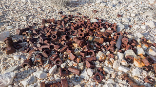
Here, the old mining road fades in and out along the wash, but I pushed my pace regardless of the terrain. Steep in places, it was amazing to think that whoever worked this land would have driven a vehicle along this route - but those were different times, when safety was usually a distant third in the rush to riches. Along the way I encountered a few old relics from days past - an old tank, laying on its side in the wash; some rusty lengths of double-walled pipe, their purpose unknown near the top of the blackened badlands.


Eventually, I gained enough elevation - perhaps 1200 feet by this point - that the road remained mostly intact - erosion lessened simply due to the smaller volume of water to which it was subjected. Here, still some 300 feet below the Up and Down Mine, I got my first real glimpse into the types of views that were in store for me at higher elevations. Stunning.

And, in the distance on the hillside - one of the Up and Down Mine's old mercury retorts stood watch.

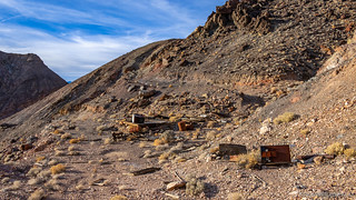
No longer picking my way up an eroded wash, my speed increased even more and when I arrived at the "twin" cabins of the Up and Down Mine, I was happy to see that only an hour had passed since I'd embarked on this adventure. Unfortunately, the cabins weren't in as great a shape as my hike times, the western most cabin having collapsed in the last several years.

The main cabin too has seen better days, though it's shelves still hold several different seasonings and salt, a pack of crackers, cooking oil, and several cans of food. These things, along with a visitor log are protected from the onslaught of rodents by a screened shelf held tightly shut with several wraps of bailing wire. Oh, and if you're interested in your own little piece of solitude, the cabin may be for sale.


From the cabins, it was another few hundred yards up to the two mercury retorts that were used to separate mercury (also called quicksilver) from the ore in which it was mined and then condense it into pure material for sale to the highest bidder. These retorts were built from all manor of scrap steel - their pieces welded together by a miner who must have been part welder and part inventor, the struggle to make a living here in the desert, evident in his masterpieces.

I could have spent hours exploring this area - poking around the various scrap piles, investigating the diggings and shafts that littered the hillsides - but I limited myself to some 15 minutes or so - knowing that I needed to make a decision: was I to continue on the remainder of the loop, or head back down the way I'd come?


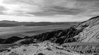
It should come as no surprise that I ultimately decided to attempt the remainder of the loop. I wondered in fact if my decision would get me back to the truck sooner - due to what I hoped was a better road - than if I tried to pick my way down the steep wash. Plus, I figured that even if I returned to the truck in the dark, it would be easy to find along Eureka Valley Road and so getting lost wasn't a problem I need concern myself with. And so, I continued to climb the final 700 vertical feet to along the high road, splendid views of Eureka Valley now impossible to avoid.

Save for the views, the high road was mostly uneventful. Along it's length, I stumbled upon a few mining relics, none of them that interesting save for one. It took me a moment to realize what I was looking at when I found it, so see if you can guess what it is.

I made quick work of the mile-long high road, and as it started to drop back down toward Eureka Valley, I decided that I'd make a short detour to the Mercury Knob Prospect. My description of the road promised that two cabins were situated just around a bend some 250 yards from the fork, but that same description failed to mention that it was also some 500 feet of elevation change in the process! Alas, my problem is that I constantly remind myself that, "I'm here so I might as well do it now," and so I headed down to see the condition of the cabins and old diggings.
The condition wasn't great, and quite frankly probably wasn't worth my time - but at least there's now no need to wonder and perhaps return just to discover the same fact at a later time.
From the Mercury Knob Prospect, I climbed back to the main road and continued south - the April Fool Prospect almost immediately visible as a gash cut into the mountain side.

Heavy machinery and blasting were likely used for this operation, but in all the destruction, there is relatively little cinnabar - mercury-rich material - perhaps an indication that its name was a bit of a reflection of its production levels.
Still, there were remains to explore, and I spent a few minutes wandering the roads that made up the prospect. An old loading platform and discarded mining equipment are scattered down the hillside and along the road, the stories of their abandonment lost to time.


From the April Fool Prospect, the road dropped steeply into another wash - so steeply in fact that parts of the descent required a jog in order to not lose my footing on the loose gravel. Soon the wash constricts into angular narrows, the sharp overhanging rocks crumbling as time takes its toll.
This was a place worth slowing down, and I did - remembering what Ken @DVExile had mentioned on our hike through Fall Canyon - that the nice thing about canyon hikes was that the view was different, even on an out-and-back excursion. I purposefully turned around several times in order to enjoy both the uphill and downhill views as I made my way forward.


And then - a mere half mile later - I popped out of the narrows an onto an alluvial fan that would take me to Eureka Valley Road some 1.5 miles south of my starting point. There was a road here that I could follow, though I quickly realized it was easier to walk next to the road rather than on it as the road itself was littered with football-sized rocks that were difficult to navigate.

Hard to make out in the photo unless you're looking for them, I realized that camouflage is exactly what makes this solution to closing a road so ingenious - to a passerby, the road looks "normal," since there are rocks everywhere in the desert, and these look just like any other. But, to a traveler on the road - and even more so to a traveler with a vehicle, these make navigating the road and extremely slow and difficult endeavor. "Genius!" I say.
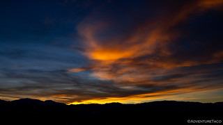
I'd reached Eureka Valley Road mere minutes after the sun fell below the Inyo's to the west, but before it fully set below the horizon. With clouds in the sky, I hoped that my 1.5 mile return along Eureka Valley Road might not be quite so boring as I'd original envisioned.
And in fact, it was not. Starting as a deep orange, the color danced along the bottom of the clouds and reflected down onto the desert around me. Eventually, as the rays of the sun got longer and longer, that orange turned to pink, and then ultimately purple just as I reached the truck.


It was without a doubt a brilliant way to cap what had been an extremely successful day of exploration and discovery. With nearly 20 miles of trails and 4000 feet of elevation gain, I was ready for a rest and some dinner.
I'd considered camping once again at the end of the Dry Well road, but my strategy of camping near my starting point for the day stuck with me and I decided I'd head northwest towards tomorrow's jumping off point at the base of an eastern spur of the Inyo mountains.
My hope was that I wouldn't be exploring these mountains alone, and I went to bed with the APRS beaconing, optimistic that I'd find another truck parked near mine when I awoke in the morning.
The Whole Story
")


Love Death Valley and want to see more adventures there?
You'll love the Death Valley Index.
Thank you for taking the time to bring a little, lot of desert to those of us suffering in the winter up north.
I know how it is, and I'm happy to be the one to "suffer" through the trip down south 😉