
A few minutes after setting off - just before 5:00am - I realized that we've been doing this whole exploration thing entirely wrong for the last eight years. That's because our first stop was only minutes from home, for half a dozen servings at our favorite healthy breakfast spot - Family Donut.

Daily calorie allocation exceeded before sunrise.
With a schedule to keep - we had a ferry to catch - we managed to eat only one donut each before climbing back into the Tacoma. And, with a strict "no eating messy food in the truck" policy - of which donuts certainly qualify - I held off for at least 12 minutes before breaking down and asking @mrs.turbodb to pass me the box, so I could sample, in their entirety, two more of the magical morsels.
That left only one more donut each as we pulled into the Horseshoe Bay Ferry Terminal, an entire box mysteriously disappeared well before we're usually even out of bed. But hey, with all that sugar, I was ready for the first couple dozen feet of a marathon!

This guy was looking for breakfast too. We didn't have any to share. (Great Blue Heron)

Our chariot, pulling in to pick us up.
Our ride on the Queen of Surrey - the only way to get a vehicle onto the Sunshine Coast - would take 40 minutes, ushering us from the outskirts of Vancouver to the town of Langdale. Speeding along through calm waters, our eyes were glued to the sky as we scoped out the cloud situation. A good number of the puffy white "view inhibitors" spread out to the north and we hoped they'd make like our donuts so we could experience the expansive coastal views we were after.

Headed northwest, to Canada's Pacific Southwest.

When you've got a lot of trees, you've got a lot of wood chips. These were on their way to a local paper mill.

Road's end. Or, in our case, beginning.
As seems common when looking for places to explore in Canada, finding anything on the internet seemed much more difficult than in the United States. Likely, this is due to Canadians being a bit more judicious about what they broadcast for the rest of the world to see, and while I didn't love it, I most definitely understood it. Ultimately, I'd reached out to Mike @POSTacoMike and he'd put me in touch with a buddy of his - Jason - who'd recommended a few places for us to check out while we were in his neck of the woods. Sprinkling in a few hikes and spots that even bozos like us could find, we had a full schedule, and planned to kick off our adventure with a visit to A&W. Because after four donuts, how can you pass up a burger, fries, and a litre of pop?
Luckily for our arteries, it wasn't yet 11:00am, so we decided to squeeze in a four mile - sorrey, 6.5 km - hike to Langdale Falls in order to mentally justify stuffing another mountain of calories down our throats.

Into the forest.

Nature's stairway.

Rusting away.
Unsurprisingly, the hike to Langdale Falls felt a lot like the hikes we do in western Washington. Light filtered in through the tall trees. Soft green moss covered anything on the ground. It was damp. "This is my favorite type of forest," @mrs.turbodb reminded me as the sound of water crashing onto rocks grew in the distance.

Soft carpet.

Gazing up at the cascading falls.
Working our way back from the falls, we discussed our plan for the rest of the day. Our first priority, naturally, was to stop for A&W fried chicken sandwiches and fries; we were starving. After that, we had to decide whether to head straight to camp at a numbered lake, or to squeeze in a second hike to the summit of Mt. Elphinstone, where - if the clouds cooperated - 360° views of the sound awaited our arrival.
Left to my own devices, I'd have headed to camp. Of all the places we'd planned - and from the single photo I'd seen - this was the spot I was looking forward to the most. I worried that a five-mile hike with a bit more than 1,000 feet of elevation gain would put us there after dark.
Reason - in the form of my passenger - prevailed, and soon we were headed up an old forest service road (FSR) towards the trailhead.

Time to air down.

This is not looking promising for 360° views.
We reached the trailhead just before 2:00pm and in the first three-quarters of a mile, we dropped several hundred feet of elevation. That's always a welcome sign when you've got 1,000 feet to gain over the course of a hike, but we soldiered on, one of us admiring the temperate rainforest through which we traveled.
And, we saw our first mushroom. Well, not actually our first - we'd seen several before this - but this is where we first realized that we'd be seeing a lot of mushrooms.
If you know the names (common and/or latin) for any of these fungi, please do share in the comments or by contacting me. I don't know what (m)any of them are, and am curious!

Want to play edible or deadible?

A nearby neighbor.

Well then, you're an interesting one! (Yellow Coral Mushroom)

Not mushrooms. Also, unfortunately - and to our surprise - not tasty. (Blue huckleberry)
We made good time through most of the hike, mostly because after losing a couple hundred feet of elevation, the trail was flat for the next mile. We did not make good time on the last mile, where the trail seemingly gained a foot of elevation for every foot of forward progress.

It was steep, but the rope was overkill.

Made it!
Happy for a break from the climb, we moseyed our way over to a radio tower and helipad that adorned the peak so we could soak in the views we'd labored so hard to enjoy.

Check out those "probably amazing" views!
Looking out into the gray, we were only half-joking as we discussed the fact that rather than using the helipad for my miniature flying machine, that it would have been much more pleasurable - or at least we would be less sweaty - had we used it for its intended purpose.

As the flying camera broke above the clouds, we could see that there were actually views. Then, like magic, it began to clear up!
Our view up Thornbrough Channel, past Woolridge Island.
Turns out that we were at the top at the perfect time, the clouds parting just as the flying the camera captured our surroundings and we pointed out a mountain peak here, or an island there. Eventually though - and with a little prodding from me, still anxious to get to camp before dark - we packed up our electronics and headed back down the mountain.

Ooo, look, another interesting specimen. Step right up to play Tasty or Toxic?
Reaching the Tacoma just before 5:00pm, we had a little more than two hours before sunset, and a decision to make: retrace our original path back to civilization - and speedier pavement, or attempt a dirt track around Mt. Elphinstone that was significantly shorter, but that would entail much slower speeds.
Hoping that slower is faster would play out on the trail as it often does in life, we opted for the unknown adventure of the dirt route and set our sights on the Rainy River FSR.

Roadway or riverbed? Why not both?

This waterfall was pretty, but we weren't sure if the bubble stripes in the lower pool were cool or a little creepy.
An hour later - it turns out, exactly the same amount of time it would have taken us to take the longer, higher speed, paved way around - we slowed to a stop, our path blocked by a guard shack stationed along the road.
Completely unexpected - and without any sort of card to raise the gate - we pulled up to the deeply tinted window hoping there was someone inside who we could talk to in order to figure out our next steps.
The window didn't budge.
Unsure what to do, I maneuvered to the side of the road - allowing people with the correct credentials to continue through the gate - and approached the shack on foot, hoping to find a phone number or other means of gaining access. As I did, the window slid open and a guard warily greeted me.
"Evening, we're hoping to get up to Lake 7," I told him, "Is that OK and can you open the gate for us?"
"Have you been here before?" he asked, before telling me that it'd be better if we pulled the Tacoma up to the window to receive instructions and register to pass through private land belonging to the Howe Sound Pulp and Paper Mill.
Despite our initial worry and a bit of a bumpy start, the guard was super friendly and had just been preoccupied when we'd originally pulled up to the window. Since nearly everyone has a pass, a quick honk would have been more than enough to get his attention, had we known he was inside. And, after a quick briefing about where to go and how to be a good human on the private land, we were once again racing the sun towards our destination.
Note: The Howe Sound Pulp and Paper company only allows public through traffic between sunrise and sunset, so if you're headed this way, be sure to show up during the day!

Looking north up Howe Sound past the mill.
The first half of the 10-mile long Rainy River FSR was decently graded, having been used extensively for logging - perhaps by the pulp and paper mill - over the years, and as we climbed through the valley, a mixture of emotions battled in my mind. We were probably - if I could refrain from stopping too many times to take photos along the way - going to make it before the sun technically set, but a thick cloud cover meant that it wasn't really going to matter. And pretty soon we were going to have to decide whether to camp up high - possibly in the clouds - where we'd likely wake to a very wet tent, or hunker down at a lower elevation, hoping to stay a little drier through the night.

That's a lot of paper.

Those had to be amazing views.
Ultimately, we decided that we'd at least drive up to the lake before making the decision about where to camp. As the road got rougher and I was contemplating the mountain faces hidden high to our south, @mrs.turbodb noticed a huge waterfall further up the canyon.

What the heck?
That waterfall - sourced by the spillway of Lake 7 - was a sight to see, but given the time, we opted to carry on with our climb, hoping to spend a little more time in the morning admiring this strange sight.
And then - with the tires straining for traction on a loose, wet, steep final ascent - we arrived!

"Wow?"
I was bummed.
Up here just a few feet under the clouds, and knowing how much of a pain it is when the tent is wet in the morning, @mrs.turbodb asked me what I wanted to do. After thinking about it for a bit, I decided that by morning, the fog would probably fill the valley, so there wasn't much reason to move from our spot up here next to the lake. We'd just have to accept that we weren't going to experience the killer views we knew existed.
With light fading, I deployed the tent while @mrs.turbodb extracted the kitchen and pulled out ingredients for dinner.
And then, as we ate, something magical happened - the clouds began to lift! They didn't disappear entirely - not by a longshot - but there was hope; we might actually see something in the morning!

Nature teasing.
Tired from a long day of travel and two hikes, we cleaned up camp and got ourselves ready for bed as night enveloped camp. It was a bit before 8:00pm when we climbed up the ladder, our view down the valley dark but clearer than it'd been all day. Trying to read a bit of the Bourne series, I didn't last long before I was fast asleep.
That Night...
I hadn't set my alarm, but aware that a full moon would rise while we slept, I lifted my head from the pillow when I happened to wake up around 3:45am.

A stary night.
The Next Morning...
I'd set my alarm for a few minutes before sunrise. Not because I'd thought that we'd be able to witness the flaming ball rising above the horizon - it was much too cloudy for that when we'd gone to bed - but because I knew we had another full day, and we'd need to get an early start. If it hadn't been for my earlier experience with the stary night, I would have been caught completely off guard by the beauty of the morning.

Sunrise over Polytope Peak.

A glassy double sunrise.

Glorious Lake 7.

In the distance, Mt. Donaldson rose high above the clouds.
Eager to share the spectacularity with my still-cozy companion, I was surprised to hear her return whistle come not from the tent, but from the passenger seat of the Tacoma. Already up, she too was admiring the colorful sky, and the complete contrast to the previous evening.
We'd lucked out!
Our spirits high, it was time to check out the spillway we'd noticed on our way up. Unlike any we'd seen previously, I theorized that it was spraying an enormous mist - rather than exhausting a steady stream - to lessen the impact of the water on the hillside, reducing the amount of erosion over time.

Spillway spray.

Valley view.
By now - 15 minutes into the day - the sun was well above the horizon and playfully illuminating the ridges above the lake. It was time to pack up camp and get underway.

Dam camp.
As we pulled out of camp, one thing still bugged me. The photo I'd seen of this place - that Jason had shared and that piqued my interest to begin with - was unlike any view we'd seen so far. Earlier in our visit, I'd chalked this up to the clouds, but with that excuse no longer viable, I wondered if we'd even found the right place, or if we were still missing the best bits.
That's right, it was Nature FOMO.
Our elevation dropped quickly as the Tacoma ate up the steep, rocky trail. Working our way around a switchback, there happened to be a break in the trees and there, before us, was a strikingly similar view to the one we'd been after. It wasn't the view - yet - but it was most definitely a view to write home about.

Towering cliffs.
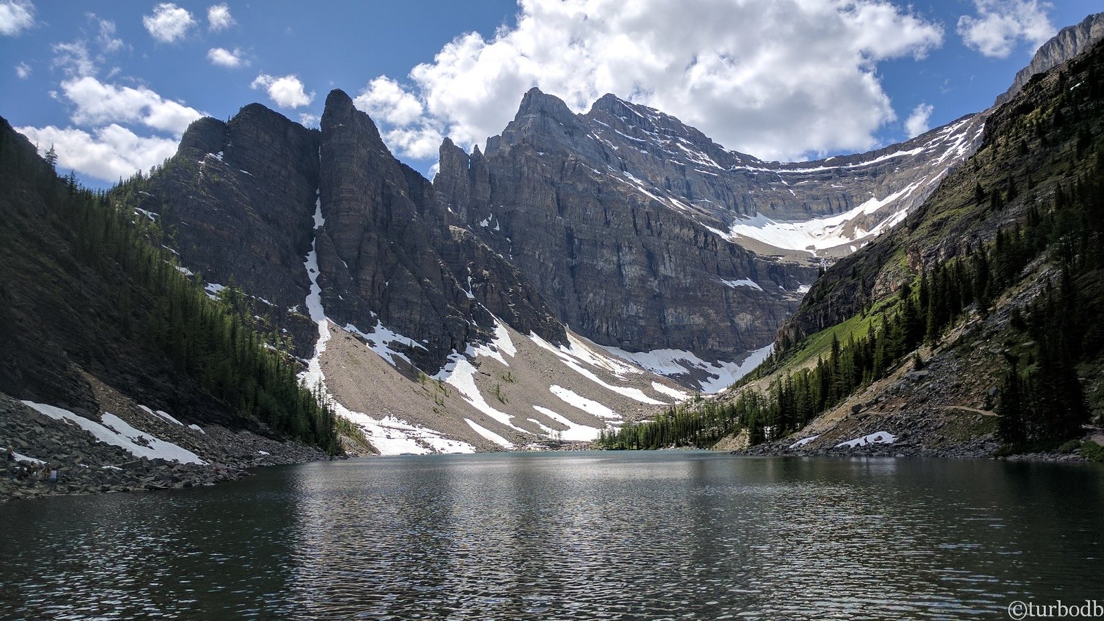
And then, a few twists and turns later, we found our reward.

The place.
From there, it was all smiles as we continued our descent. The last 15 hours had been a weather-induced rollercoaster, and our - or at least my - emotions had been along for the ride. Thankfully it'd gone the way that it did, everything only seeming to get better as we made one choice after the next, our hand consistently coming up aces.
Really though, the house always wins, and today was no different.

Turns out today, it was "down into the clouds."

Though we'd have preferred clear skies, it was hard to object too much to the softening of the rocky cliffs around us by the low-lying gray.
Needless to say, our first day on the Coast had been a smashing success. Perhaps not quite as clear as it might have been a few weeks earlier, but beautiful nonetheless. A trend that we hoped would continue, the clouds lifting as we headed towards our next destination.
The Whole Story


Filed Under

Beautiful photos, reminds me a lot of when we drove and hiked along the Washington, Oregon, and California coast coming back south some years ago. Beautiful green, damp, fern forests and rocky coast line. Thank for sharing.
Thanks John! This landscape is definitely a lot like the coast of the PNW, and something that we were commenting on the entire time we were there.
@mrs.turbodb said that it was her favorite type of forest every time we were hiking!
I love your picture stories, the drone is a nice addition. Great work
These are my hood's scenery. Your photos are just staggeringly beautiful - as good as real view! Thank you!
Thanks Ben, always puts a smile on my face when I hear from folks who know a place and they enjoy it! Hope you've had a chance to check out the rest of this trip. It was our first time to the Sunshine Coast, but it surely won't be our last.