Preface
You'll note pretty quickly that this trip took place right near the beginning of what has become a worldwide Covid-19 pandemic. At the time of the trip, there had been approximately 600 cases and 24 deaths across the USA. 18 of those deaths were from the Life Care assisted living community in Kirkland, WA. Schools at all education levels were still open, and while some companies were starting to allow employees to work from home, it was not widespread, and definitely not mandated. There were no travel restrictions - or even really talk of such restrictions on a broad scale - in place. We were healthy, and hadn't had any high-risk contacts.
I say this to give some perspective, since things have clearly changed since then.
Part 1
Leaving home for adventure was a little different this time. Looking back now, as we headed south out of the Seattle area, we were leaving behind what would turn out to be one of the early epicenters of the Covid-19 outbreak, just before more info on the severity would come to light and large-scale cancellations and closures would become part of our world's lives.

Our moods were mixed - on the one hand, it was nice getting away from the stream of news for somewhere a little more relaxed; on the other, we were a little concerned about what might happen over the course of our trip, and how those changes might affect our ability to complete our adventure - originally planned for the next several weeks.
Our plan - you see - was to drive down to the eastern Mojave - between St. George, UT and Las Vegas, NV and explore for the better part of a week. Then, as we'd done the previous year (trip report) at Anza-Borrego Desert State Park, we'd leave the truck in the desert (under the generous care of Brent @PcBuilder14) and fly home for ~10 days, before flying back for another week of adventure. That would amortize the long drive and give us a better dirt-to-pavement ratio by the time we were all done.
For the time being, we did our best to put the world's (still believed to be largely China at this point) situation out of our head as the miles ticked away, the truck humming along as happily as ever. By the end of our first day of driving, it was 11:00pm when we found ourselves just south of Wells, NV at a little spot that Mike @Digiratus and I had camped the last time I'd been to St. George, before starting the F.U.Rain trip through the Grand Canyon and vast lands to the east.
With several more hours of driving before reaching our final destination, we were up by 5:30am and out of camp 30 minutes later. The sun was just cresting the eastern horizon as we headed south, and it was going to be a beautiful day.

Having skipped breakfast, our stomachs were screaming by 10:00am. When an opportunistic sign for Cathedral Gorge presented itself, we decided that'd be as great a place as any to feast on a few Cheerios before turning east towards Utah.

The colors at Cathedral Gorge - precursors for what we'd see the rest of the trip - whet our appetite for more, so I pushed the skinny pedal a little further down to shave a few minutes off of our drive. Turns out, those minutes were used for a second unplanned stop as we passed through Mountain Meadows and the several memorials that dot the sides of the highway.

Mountain Meadows was the site, in September of 1857, where some 140 emigrants bound for California found themselves attacked by Mormon militia over a period of four days. On the fourth day, the Mormons entered the camp under a white flag. The flag however was a trick; later that same day the militia separated the emigrants into three groups: men (and boys), women (and girls), and the youngest children. All but the youngest children were then massacred in a matter of minutes and were left where they fell, all of their belongings plundered. It wasn't until two years later - in 1859 - that the US Army came to bury what scattered remains they could find. Seventeen years later, a federal grand jury indicted nine men associated with the siege, but only one - John D. Lee - was brought to trial and convicted. He was executed in the valley in 1877.Women's Memorial Sign
We didn't spend long at the memorial, instead pushing on towards the hikes and discoveries on the beauty of nature that we knew would fill the remainder of our day. And so, right around lunch, we turned off of pavement, onto dirt, and towards our first trailhead at Lower Sand Cove.


The hike through Sand Cove would eventually lead us a little over a mile - through an outcropping of red rock - to a tinaja known as The Vortex. We ate a quick lunch and then headed down and across a wash that separated the parking area from the colorful rocks that rose out of the ground in front of us. A Great Basin Collard Lizard scurried away as we made our way down.

Soon, we were out of the wash and onto the sandstone, the colors and erosion patterns already dramatic as they ranged from white to red before our eyes.

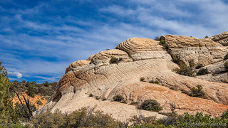

Here, we stumbled upon a fault line, its straightness - in the center of the photo - similar to, but conspicuously different than the rest of the cracks in the rocky landscape.

While all uphill, the inclines were reasonable and we followed the path I'd loaded into Backcountry Navigator up through a large bowl towards the ridgeline. The higher we got, the more dramatic the views.

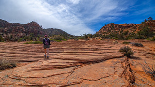

A little more than a mile in, we reached the summit. There, we found a puzzling tinaja - I mean, we'd expected to find one, but this one didn't look anything like what I'd seen.

As I roamed around taking photos of what I figured must be the tinaja, @mrs.turbodb did a bit of exploring herself, accidentally stumbling on a couple who'd decided that a rocky ledge behind the tinaja was the perfect spot to "get back to nature" if you get my drift.  That discovery sent her back my direction and even a little further... I followed, and suddenly we stumbled on the tinaja we'd been looking for!

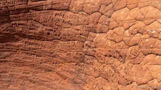
Relieved that I wasn't going crazy - or crazier than we all already know - we spent a few minutes enjoying the perfect weather and views from this splendid vantage point and reading some of the names that had been carved into the brick-shaped sandstone that ringed the tinaja.

As we were getting ready to head back down, @mrs.turbodb looked off into the distance and spotted what she thought was a secret garden of cairns. Neither of us had expected - and I'd not found in any of my research - such a thing, but there was no way we were going to leave without checking it out - after all, who knows if we'd ever be back this way in the future, or if the garden would still exist if we were.

Like all good gardens, this one fit its surroundings perfectly, its creators surely pleased with their work. I know we were, even it if wasn't as natural as most of the wonders we find in the wild.


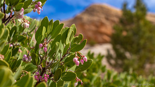
With more to do in the day, we figured we ought to start heading back and choose a route down from The Vortex that was different than our leisurely route up. Much steeper, we got to do some fun bouldering and down-climbing as we made our way back to the base of the red rock back through the blooming manzanita - abuzz with bees - in the wash separating it from the Tacoma.


From Sand Cove, we made our way west on dirt roads - through the small town of Gunlock - to what I hoped would be the first of many amazing petroglyphs for this trip. Of course, that would require us actually finding the ever-elusive rock art, since many times all that is discoverable beforehand is a general location - but that was just fine with us, that discovery is part of the adventure!

The road to The Naming Cave and the petroglyphs it held was a fun one, requiring us to air down - something I'd hoped to avoid until the following day, knowing that we had a several dozen miles of pavement in front of us before turning onto dirt for the remainder of the trip.

An hour later we found ourselves at the next trailhead. This one was theoretically shorter - in length - than the last hike, but we had no idea how long it would take to find the hidden petroglyphs once we were in the vicinity.

As we explored the red rock outcropping where I thought The Naming Cave would be, I was pretty sure I'd discovered the cave from a distance - but there was a problem: how to reach it? The cave - you see - was on a ledge some 30 feet above us, and all routes to it seemed a bit sketchy without the proper equipment. The exploration for an access route provided several cool discoveries as well.

Wind-swept sandstone, nature's cubby cabinet.

Mini-arch.
Keen to get to the cave itself, I finally decided on what I thought was the least-sketchy route. Content to relax under the warm sun, @mrs.turbodb decided that least-sketchy still wasn't her cup of tea this afternoon, and so I pushed on alone - to great success!

The cave, its roof having collapsed at some point.

The canvas.

The view.
Thrilled to have found what we'd been looking for, and confident that if I'd made it through the sketchy traverse to the cave, that I could surely make it back, I retraced my steps to a peaceful @mrs.turbodb and shared the photos with her before making our way back to the truck, which had been standing guard at the trailhead.

On our way once again, we headed south from The Naming Cave to Old Highway 91. The route was rocky and slow, several sections recently repaired - and already eroding again - from recent rains.
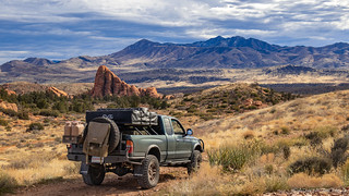

Through all of it, the views were astounding. It seems I never tire of the brightly colored earth poking up through the trees, the orange and blue contrasting so well against each other, the clouds providing interest in the sky.

At this point our plan had been to find camp on some BLM land near the trailhead for our first hike the following morning, but a quick check of the weather alerted us to the fact that rain was going to start around 10:00pm and carry on through the entirety of the next day. As such, we decided that it might be better to knock out that hike today as well!
And so, just outside the town of Santa Clara, we pulled into the parking area for the Anasazi Trail and started up the hillside. Being so close to town, the trail here was very well traveled, and we had no trouble finding our way. What I did have trouble with was remembering why I'd marked this trail in the first place. I had a route, but no waypoints along the route, so we simply continued on, hoping to find whatever cool thing had caused me to add the hike to our itinerary. 
A mile in - and near the apex of the loop trail - we found what we were looking for - more petroglyphs!  At first, we thought there were just a few, but as we continued to explore, it turned out that there were dozens of separate panels, each with their own unique art. It was quite enjoyable to wander amongst the rocks, discovering a devil-man over here, goats and a weird alien over there, etc.
A few of our favorite discoveries:

You little devils, you.

Alien under a cloudy sky.
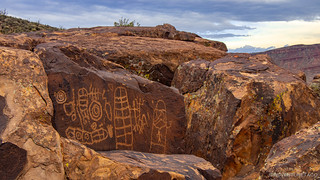
Is that a Stormtrooper on the right?

So many humanoid figures - more than I've seen at most other petroglyph sites.

By the time we'd had our fill - and made it back to the trailhead - it was a little after 7:00pm and time for us to find camp. I'd done a bit of research and found a nice little BLM spot just to our southeast, and so that's where we headed. Things are rarely as easy as they seem however, and this time was no exception - we scouted out several possible camp sites, but each had their drawbacks given the ominous weather forecast and several groups of 'mericans who were out on the public lands shooting their guns in several different directions.
Eventually though, we found what we thought would be a great little secluded spot on the hillside and setup camp before making what is my favorite camp dinner - tacos and guacamole. 

Everything seemingly sorted, we retired to the truck for a bit of reading, to download photos from the days adventures, and to wait for the storm - which we could see coming - to roll in. And then, a flash. And another. Now, we weren't the highest thing on the ridge, but we weren't the lowest either - and over the course of the next hour or so, as the lightning got closer and closer, we both started to get a bit nervous - it wasn't going to pass by to our east or west as it made its way from the south, it was going to pass directly overhead.
Just as the first drops started falling, we decided to seek lower ground. Luckily, we'd passed something in our earlier explorations that we thought might work, so we quickly folded up the tent and headed that way. And so it was that as the rain started, we opened up the tent and climbed right in. Tired from two long days of driving and hiking, I put in my earplugs and was asleep within minutes, dreaming of what the next day would bring.


Wow, never heard of tinajas, how cool!
And that cave with the petroglyphs - fascinating.
I wonder how old all the petroglyphs are...?
Cool lizard too!
The petroglyphs are on the order of 4000 years old. Interesting how the cave had collapsed before the rock art was done, which means it's been that way for a long time.
Any chance you have Gaia and can send the route you took? Looks awesome and I hate route planning.
Meant to post that on the Owyhee trip not the Mojave.
Hey Tom, I don't generally have GPX files for trips. My trip reports are generally detailed enough to spend a bit of time with an online map and the text of the report and get a pretty detailed idea of the route we took! It's a little bit of trip planning, but generally not too bad, ?. Cheers!