
For the last four months, my sole destination has been Death Valley. This would be my sixth trip to the National Park, and with temperatures warming up elsewhere, likely the last visit of the season.
I couldn't wait. Ever since December, when I'd ventured up Pleasant Canyon and South Park on the Back for More trip with my buddies Mike @Digiratus, Zane @Speedytech7, and Monte @Blackdawg, I'd been trying to get back. I'd planned an entire trip around that loop in early January, but snow levels turned out to be low at the time, and @mrs.turbodb and I were forced to change our plans at the last moment - not that exploring a series of talc mines at the southern end of the park was any sort of travesty! 
Still, the draw of spending a couple days wandering through the Panamints, following side roads, and exploring the mines more fully continued to simmer in the back of my mind. And so, for the third time, we set out to finish what we'd started.
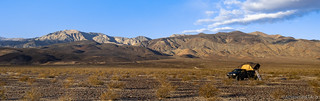
After a long drive and not enough sleep, we climbed out of the tent to a clear - but very windy - morning in Panamint Valley.

Dust was already in the air as we looked north - past the Welcome to Death Valley sign - to the Panamint Dunes.
Opting to skip breakfast for the time being, we got the tent squared away and headed south towards Ballarat, the wind blowing a constant 30mph - with 50mph gusts - in the same direction. I was sure that we were getting some of the best gas mileage I've ever gotten in the Tacoma - though it was still certainly below 20mpg,  . Soon, we were turning off of Panamint Valley road and headed east, pausing momentarily at the radio installation just before Ballarat, before bee-lining it to South Park Canyon Road.

Having driven by numerous times, we've never stopped at this station before. It's not all that interesting, though I bet it enables a bunch of the jets we love seeing overhead.

The initial couple miles of South Park Canyon Road aren't all that interesting, but the overlook of Panamint Valley signals a dramatic shift in the coolness of the route.
As we admired the views out over Panamint Valley - or southern Panamint Valley, since wind-blown dust was already obscuring our views to the north - the rumbling of jets thundered overhead. Higher than they sounded - and always so far in front of the sound - we didn't see them at first. Eventually though, I spotted a glint high above.
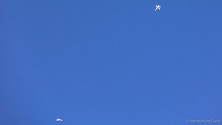
Dogfight!

Spiraling around each other, the planes lost several thousand feet of elevation as they tried to gain the advantage on each other.
We probably watched for a good ten minutes or more as the planes jockeyed for position, sometimes breaking away to gain altitude before regrouping for more simulated battle. It was the first time I'd seen that on one of my trips, and as always, a fantastic experience.

Each of us getting a little hungry now, we took one last look over the valley before climbing into the Tacoma.
One of the treasures of South Park Canyon is the narrows. Beginning just after the overlook and continuing for nearly a mile and a half, they twist and turn through vertical walls of 1.8 billion year old gneiss speckled with barrel cactus. From above, this part of the canyon must look like a wiggly fissure unable to host a road; at places it comes awfully close. Had we gotten a little more sleep, and perhaps a bit of breakfast before entering these halls, they would have been pure joy. Even tired and hungry, we each admired the scenery as we steadily climbed toward our next stop.

Entering the canyon, the rock here representing some of the oldest in the entire Panamint Range.

This small saddle has such an interesting shape to the layers of stone. And - surprisingly - it is only about 10 feet thick; it's a miracle that floods haven't burst through as they rush down the wash.

The wash narrows.

As long as it's dry, it's plenty wide for the Tacoma.
Just before 10:00am, we reached our planned breakfast destination: Briggs Camp. Unfortunately for us, both cabins were occupied, and so breaking out our cereal and blueberries to enjoy on the deck - or in the luscious backyard of the upper cabin - was out of the question. Instead, we greeted the current residents and set off on foot to explore what we could without disturbing them too much.
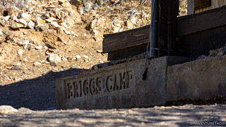
In case you're not sure if you've arrived.
Visitors are welcome to stay at Briggs Camp on a first-come, first-serve basis. However, treat these cabins well and leave them better than you found them. Follow the rules posted inside the main cabin, especially directions to turn the water on and off. Only by showing the proper respect, will places like this continue to exist - for those who find them to enjoy.

Situated in the middle of the camp, this building was both a small mill as well as a workshop.
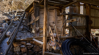
The small mill couldn't have processed much material from the small shaft 350 yards to the east
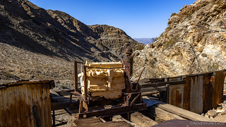
Atop the mill, the appropriately sized power plant.
The cabins are maintained by an organization called Friends of Briggs Camp, in conjunction with the Bureau of Land Management (BLM) as they are just outside of Death Valley National Park. Both cabins are amazingly clean, with beds, kitchens, minimal electricity, and even a phone line for ultra-local calls, should the residents be on speaking terms with each other.
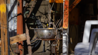
Both cabins have running water, though it should still be filtered before consumption.

At the upper cabin, two ore carts - loaned in 1999 from the Keystone (Lotus) Mine in Goler Wash - were in use until the mid-1990s when they were placed here for safe keeping and enjoyment.
While we weren't able to get into the upper cabin, we did find our way into the lower one for a few minutes, and it was one of the nicest I've seen. It's clear that those who've been here before have taken good care of it - something expected by all visitors.

The aptly named Stone Cabin, built 30 feet up the canyon wall, to keep it safe from floods that may otherwise wash it away.
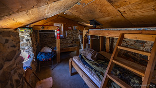
While the deck and roof are made of wood, the walls of the cabin - both inside and out - are mortared stone.

A well-appointed kitchen with all the necessities and then some.

Mission control.
Deciding that it would be a little weird to unpack the Tacoma in front of the occupied cabins for breakfast, I suggested to @mrs.turbodb that we head a bit further up the canyon where we could enjoy our cereal and give everyone a little more of the privacy that's so often desired on desert excursions. She agreed, and almost immediately we began climbing the shelf road behind the cabins towards the sketchiest section of trail on the entire trip.

There was once a log bridge here that could support 6,000lbs when it was built in 1998. Given that the Tacoma weights 5500lbs, and that the capacity of the bridge declined over the years, we were lucky that the BLM replaced the bridge with a more permanent solution in 2018.
Just beyond the bridge is a section of road known as Chicken Rock. It is here that just a few months earlier, I'd taken the wrong line as I'd come down the trail - nearly sending myself over the edge. It is a section of trail perhaps best described as follows:
For the next 300 yards [the road] squeezes down to a single lane blasted into the rock wall 150 feet above the wash, too narrow to turn around. This may well be the hairiest spot in all of the Panamints. If you slip off the road, it will take nothing short of an Army helicopter to haul out your wreckage.
In November 2002, a long section of the cliff-hugging road just above the bridge collapsed, leaving only 3 to 4 feet of roadway and making the road undrivable. The road has been cleared since then, but it may happen again. If you have passengers, let them out at each rough spot. They can guide you from outside, and in case of an accident fewer people will get injured.Hiking Western Death Valley

The correct line, which feels wrong because of how off-camber the truck feels as the passenger tires ride along the uphill shelf. There's not enough width in the road to stay left - toward the edge - which can look like the right line.

Checking out the situation. At this point in the obstacle, the suspension is crossed up and can lead to wheel spin, a loss of traction, and slippage toward the edge of the road.

Up the ledge.

Now it's just a matter of driving out.

I noticed that it was a close call with the rear diff and the edge of the uphill shelf.
With Chicken Rock behind us, I can't really convey the sense of relief I felt - it was, I suppose, an irrational amount. After my last encounter at this spot - when I'd heard Monte yelling at me to stop so I wouldn't drive off the edge after choosing the incorrect line - I'd only built up the difficulty of this place in my mind. The worry that there would be snow or ice, combined with the fact that we were headed uphill - the harder direction - this time, all contributed to my anxiety.
And so, now much relieved, I looked over at my copilot and suggested we find a place to eat. Luckily for us, the lower Honolulu workings of the Thorndike Mine were nestled just up a side wash, providing a bit of shelter from the gusting winds. Parked at the edge of a tailings pile, I set about poking around the remains, while @mrs.turbodb broke out a well-deserved meal.

This old tin shed housed the generator and pumps used to power the Honolulu workings of the Thorndike Mine.
One - of two - old air compressors in the shed; used to power the mine's pneumatic drills.
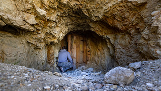
What have we hear?

The tunnel was a straight shot, reaching more than 250 feet into the mountain. As is the case with all the Thorndike tunnels, the walls here are cracked and loose. My recommendation to others would be to keep out!

This shaft and small stopes yielded rich zinc sulfide.

Back to safety. And breakfast!
As we ate breakfast, our conversation turned toward what lay ahead, as I related to @mrs.turbodb that it was - as far as I knew - mostly clear sailing from here as we explored the canyon, park, road spurs, and mines that the area had to offer. Neither of us had any idea at the time that the stress of Chicken Rock would be the least of our concerns by the end of the day, much less by the end of the trip!
For now though, we wrapped up breakfast and climbed back in the Tacoma to push onward and upward toward South Park, the upper canyon much more open than the lower narrows; grand canyon walls rising around us, blue sky blazing overhead.

Colorful blankets of stone.
The colorful rocks in much of the upper canyon belong to the Kingston Peak Formation. Composed of limestone, sandstone, and a coarse conglomerate deposited during a glaciation period one billion years ago, the layers have been intensely deformed by Mesozoic metamorphism.

Spectacular exposures of limestone as convoluted as intestines and flattened like pancakes occur right along the road.

We spent quite a bit of time here, having never seen anything like this before!
Not much further along, we found a wide spot in the road to park the truck and set out across the hillsides towards the upper - Big Horn - workings of the Thorndike Mine. Even with our map, finding the old "road" (which was only - at best - a burro trail at its peak) proved to be a bit of a challenge, but we eventually did and followed the meandering path as it switched back and forth up to the mine.

Rounding a ridgeline, the trail became more visible as it switched back and forth toward the most interesting of the Thorndike workings.

Fantastic views, on a sunny - and very windy - day!
After a mile of trekking, we arrived at the Big Horn workings, some 1,100 feet above the Honolulu that we'd visited below.
Mule trains hauled out the ore until 1924, when Thorndike built the road up South Park Canyon and trucks replaced the mules. An aerial tramway was then erected between the Big Horn workings and the road at the Honolulu Camp. The mine was intermittently active until 1944 and produced at least 460 tons of lead/zinc and 5,000 ounces of silver.
John Thorndike and his wife had other ambitions besides mining. In the 1930s they opened a few tourist cabins below Mahogany Flat. The cabins were later torn down and replaced by a campground, which still bears their name.Hiking Western Death Valley
What surprised us most as we did was the level of development present at this site - there were nearly a dozen old stone foundations, as though miners had lived here, saving themselves from hiking up and down. With winds now reaching 40mph and temps in the low 40s (°F), we tried to poke around quickly - or at least more quickly than we might have under calmer conditions!

High winds and winter weather haven't been kind to the site. This collapsed building appeared to be a combination storage building and cabin, one side packed with ventilation pipes, the other containing an rusting old cast iron stove and bed frames.

Broken, unused crucibles.
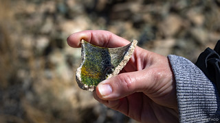
A used crucible, with whatever was melted inside, still present to this day!

Signs of life.

A blasting shed to hold explosives, or a root cellar for cold storage, this dugout was only about 10 feet deep and lined with shelves.

Leading out of the now collapsed shaft, a rail bed along which ore was carted, before being dumped into a chute.

At the bottom of the chute, a second rail line ferried the ore along the hillside to the top of an aerial tramway, where the ore would be ferried down to the lower Thorndike, to be trucked down the canyon.

The top of the aerial tramway, a windy, dusty, Panamint Valley, below.

An old ore bucket from the tramway.
After spending half an hour poking around - and being super excited to find our first-ever ore cart, and a really nice ore bucket - we headed off the ridge and back down the trail, happy to get out of the chilling wind. We made quick work of the trip down, what with it being much easier to stay on the trail, rather than find it in the first place!

Desert bonsai.

As we descended, @mrs.turbodb pointed out this textbook specimen of a dip-slip fault to me!

Even building this burro trail had clearly been a lot of work back in the day!
Having completed our exploration of the Thorndike, we rolled quickly through the willow arches of Colter Spring, before popping out at the western edge of South Park, high in the Panamint Mountains. There aren't many high-mountain meadows that I've discovered in Death Valley, but I was immediately reminded of Hidden Valley, just north of Hunter Mountain, as we rolled through the low-lying sage towards the maze of roads on the opposite side of the valley.

Driving this tunnel in the late spring or summer - when the willows are full and covered with green foliage - must be quite the experience.

Reminiscent, perhaps, of Toto's Africa.
It was at the eastern edge of South Park where we spent the majority of our time exploring. A couple of mining camps there still have a reasonable number of remains, and there are enough old vehicles that one could start their own pick-and-pull franchise. All of it - of course - was worth a look!
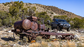
An old pump/compressor truck of some sort - perhaps a mobile rig for powering pneumatic drills in the mines.

This dump truck has seen better days. Still, the leaf springs have a nice arch, and the engine is still there, so it's doing better than most!

Just barely better. The spark plugs could use servicing.
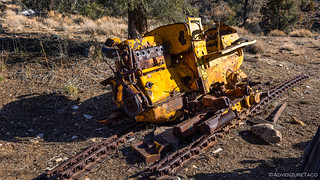
Anyone in need of a bulldozer? Minor maintenance required.

If the other vehicles we'd seen were work trucks, this was clearly the daily driver. Until it wasn't.
Besides the vehicles, there were also a few cabins and structures - some on the road, others just a short hike away - that we poked around at for a good hour or so, speculating at their purpose, and wondering what exactly the folks who used to call these places home, were after. Whatever it was, one thing is certain - life here wasn't easy, and it probably wasn't all that lucrative, either.

The bottom of an old tramway, where ore was dumped from buckets into the chute, to be loaded into the dump truck we'd seen earlier.
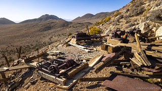
At the top of the tramway, the upper tower had collapsed, but a collection of engines, winches, and compressors stood guard outside of the inclined shaft.
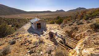
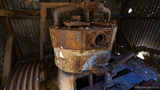
At a lower level working, an old tin shed - it's corrugated sides flexing in the wind - looked out over the valley, a generator inside still bright yellow after all these years.

This generator once powered the air and water systems used to bore the several-hundred-foot shaft into the hillside behind the shed.

Today, the tunnel provided a nice respite from the wind. I'm sure for the miners, it also provided a shelter from the summer temperatures outside!

An old cabin. Not long for this world.
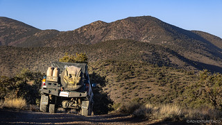
It was right around 4:45pm when we wrapped up our exploration of the roads and spurs in South Park and headed just a little further west - to the ridgeline road overlooking Butte Valley, and leading to Rogers Pass, still some 1,200 feet higher than our current position. I'd considered camping at the end of this road - sure that sunrise over Butte Valley would have rivaled the best we've seen in the park - but the winds continued to blow and the overlook was completely exposed. It was not a recipe for success, when we were both already running on three hours of sleep in the last 48.
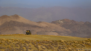
While the view was dusty today due to high winds, I'm sure this is one of the more spectacular views in the park.

Striped Butte, rising up in the valley below.

The entirety of Butte Valley, with Megal Pass to the right and Warm Springs Canyon to the left.
We were still at too high an elevation for spring to really have taken hold, but there were definitely signs that it was on its way. A few small purple flowers, and a ton of curled grasses - strangely all laying on the ground as though they were dehydrated - dotted the hillside. If anyone knows what they are, I'd love to update the story with identification.
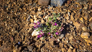
Spring is coming. (Woolly Locoweed, Astragalus mollissimus,)
What are you, you strange snake leaf?!
Pointed north now, we followed the trail - a very steep one along the ridge - until we reached Rogers Pass, where William Manly and John Rogers crossed the Panamints to bring supplies to 49ers trapped in Death Valley, eventually leading the Bennett and Arcane families to safety via the same route. It was here - on Feb 14, 1850, that one said, "Goodbye Death Valley!" giving the valley its name.
Along the ridge towards Rogers Pass.

The apex of our route. From here on, we would be headed down Pleasant Canyon.
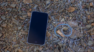
It was - as we were contemplating camp, and headed through the grove of pinyon pine at the top of Pleasant Canyon - that I initially heard a clunking sound. To me, it sounded like it was coming from the front of the truck, as though something was dropping down and hitting the skid plate as the suspension flexed over the undulations of the road.
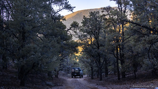
Such a change of landscape from earlier in the day - I counted on these trees providing us a bit of shelter from the gusty winds.
Getting out to inspect the situation, my initial investigation included kicking the front skid plate in several places to ensure that it was still tightly secured (I've had issues with bolts backing out in the past), checking to ensure that the bolts securing the front diff - the only thing I could imagine dropping onto the skid plate - was secure, and using a flashlight to verify that there was nothing else hanging down and causing problems - there wasn't.
Out of an abundance of caution, I wandered toward the back of the truck to check things out. The sound - I was sure - was coming from the front, but better safe than sorry in a situation like this.
And then, I saw it - as I was checking the bolts for the rear shocks, my eyes wandered just a little further forward - the driver side main leaf was busted!

Not good. Not good at all.
I knew immediately that this could spell some serious trouble. Capital "T" type of trouble.


Oh, man...you really left me hanging! When does the next episode come out? UJ
? Next part is on Monday, I think. Glad you enjoyed this one!
I don't know if I can wait till Monday! UJ
We were recently out in Butte Valley (3/20) and were considering heading up South Park Canyon Rd but the wind was too much for us to accommodate a stay up there.
Looking forward to the next installment!! As always, great write up!
Thanks Robert! Love it down there in Butte Valley - one of my favorite places in DV! We were hoping to camp up there on the ridge overlooking Butte Valley, but it was windy for us as well (as you can tell from the dust in the valley)!
Dan,
Great pictures and write-up as always.
WOW another great blog. Love the southwest 395/death valley region. You are a great photographer as well as brave desert explorer! I am fine on steep narrow, but when the departure angle threatens to roll me off a cliff, , , or rocks slide off my runners, , ,
This is why I want to replace my 2002 F150, , , , after 300k miles, many of them on rough roads.
Broke a leaf many years ago (bailing wire & duct tape don't fix that) but not bad enough to be stranded (able to drive home & replace). As always, great photos but I know that is a route we'll NOT be taking, too old for those kind of thrills now, LOL. In the old days we did get in some situation when the road ran out & we had to back down some mountains, not fun.
Here, yesterday we went out into the hills photographing poppies, enjoying (HA) gale force winds but that's the desert. Did get a bit concerned on one narrow dirt road that had a drop off & finding no place to turn around but with some back & forth worked it out.
Always enjoying see/hearing your adventures and itching to get out with the truck more this spring but when it's not as windy. Looking forward to hearing the rest of this trip next Monday and the solution to that broken leaf.
Thanks John, today's update is on its way via email and posted to the web site already! Glad to hear you're getting out in the poppies, this has to be a beautiful time of year down there when they are all in bloom!
Looks like a great trip until....
? I know what you mean Jim. Really, the whole thing was a great trip, because things like this are good learning experiences... when you look back on them. After the fact! ?
Great report guys! And always in amazement at the all things I MISS running the same trails... Which proves I need to get out of the truck and hike more. Keep it coming!
--Paul
Thanks Paul!
Great report on this most excellent trip. Your photos are sensational. What camera do you use? I love SP Canyon and have logged several hours exploring its many hidden gems. On a hike up to Big Horn four years ago came across a pair of miner’s overalls in the back of an abandoned test shaft. They now hang at Briggs Cabin.
Thanks Brig, glad you enjoyed it! Wish I'd had a chance to get inside Briggs Cabin but maybe it won't be occupied next time! Here's the camera setup I use, as well as my philosophy on photography.