
Even with the wind - and intermittent snow - buffeting the tent through much of the night, a good pair of ear plugs enabled us to get a reasonable night's sleep at the southern end of the Mojave Preserve's Mid Hills, near Hole in the Wall. We'd camped in this spot once before - when there was much more snow on the ground - and so upon waking up just as the sun was peeking over the horizon, I climbed out of the tent to do a bit of exploration.

Knowing of some nearby petroglyphs, I headed east - a half mile or so along the base of the mesa - to check them out. My recollection was that these weren't the most amazing glyphs, but when we'd visited them the first time, we had very little experience with rock art. I wondered - though I tried not to get my hopes up - if there were more in the area that I hadn't even thought to look for last time and that I might find this morning,
When visiting rock art and ruin sites, be respectful.
This is most easily done by following the Leave No Trace principles; leaving the place exactly as you found it and taking with you only photographs and memories. In case that is not clear enough for some reason, here are examples of respectful behaviors:


As I made my way back to camp, I climbed up the face of the mesa to some wind caves that I hoped might have been used as shelters. Facing east, they would have warmed up in the morning and been cool in the afternoon; at a few hundred feet above the valley floor, they would have given their inhabitants a nice vantage point of the surroundings.

After a family whistle from the cave high above camp - to let my lady know that it was time to brave the cool, windy day - I made a quick detour into a short slot-canyon-esq section of the ring loop hike before heading back to camp.


Soon enough, breakfast was eaten, camp was stowed, and @mrs.turbodb had assembled another series of tasty turkey sandwiches for us to pack along our single planned hike for the day: an 11-mile excursion through the highest concentration of petroglyphs in the entirety of the Mojave National Preserve.
That is, after we braved the - reportedly - very flexy road to get there.


I'd allowed nearly an hour to cover the seven flexy dirt miles to the trailhead, but with a little deep sand - easily navigable even with full tire pressure - being the only excitement, it was only a few seconds after 8:16am when we pulled into a sandy side wash for a warm-up to the main event of the day.
The search was on for a small arch.


I think.


Having squandered a full 17 minutes enjoying the cacti, finding the arch, and returning to the Tacoma, even a couple more miles of sandy driving wasn't going have any meaningful impact on our schedule - this was a day that we were going to be done early!
Or, so we thought at the time...

And so, just after 9:00am, both of us lathered in sunscreen - and with our lunch and camera equipment stowed for the 11-mile stroll down ██████████ - we set out.
The majority of the wash is both broad and relatively flat. In fact, over the course of the 5.5-mile descent, the wash drops only 800 feet, making the entire trek a leisurely affair but for the soft sand under foot. Staying to the edges of the wash - or on more solid gravel bars - helps immensely, and by the time we were done we'd developed an eye for the most stable path.
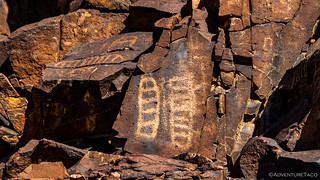
That's not to say we didn't have a lot of up-and-down throughout the day however, as much of the rock art - primarily petroglyphs - was located 50-100 feet up the darkly varnished walls, giving us the "opportunity" for plenty of exercise.

Not knowing exactly where we'd find the petroglyphs - I'd marked a couple of points where I suspected the art would be, but figured that we'd surely notice them as we walked the wash - we started by walking down the middle of the wash. At more than 300 feet wide, I soon realized this was a mistake - we couldn't see either side with any amount of detail - and I suggested that we head to the east side as it looked more promising from a boulder perspective.

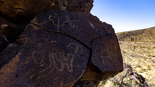
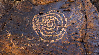
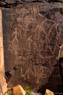
Almost immediately - and for more than the next mile of - our decision paid off! There were literally thousands of glyphs along what was once clearly a highway for the Chemehuevi and Mojave people who called these lands home.
There's no good way to share the full experience, but here is a smattering of what we found.


It took us more than two hours to make it through that mile of wash, and - with the petroglyphs thinning for a moment as the wash widened and the varnished boulders gave way to rolling hills - we both knew that we'd only scraped the surface. Now, with more than eight miles to go, we made the decision to pick up the pace for the next several miles. There - where the wash narrowed dramatically, I hoped we'd find even more of these fantastic figures, giving us the opportunity to ponder their meaning so many years after their creation.


We made it through the narrows and to the apex of our hike - technically at the lowest elevation - four-and-a-half hours after setting out. Just before 2:00pm, this - where the wash meets a second access road - was our turnaround. We hadn't seen any additional rock art in the last couple of miles, but the hike had been so pleasant - save for the soft sand constantly getting into my shoes - that I don't think we minded a bit. Plus, turning around meant that we'd get to take an alternate route back, perhaps with more rock art along the way!

Upon reaching the edge of the area where the highest concentration of petroglyphs had presented themselves on the way down, we followed a bend in the wash wall up a small tributary to the east. Once again we hit the jackpot, with entire walls of varnished stone covered in figures and shapes. It was a good thing this was the only hike we had planned for the day - we weren't going to be getting back as early as we thought!


Eventually - as has perhaps happened for everyone reading this story - even we were overwhelmed by the shear quantity of glyphs and we threw in the towel on trying to see them all. Certainly, one could spend days - or weeks - scouring this area, discovering more rock art, shelters, and signs of habitation.
We on the other hand were getting hungry and so as the sun began to drop below the ridges to our west, we completed the final mile to the Tacoma. There, the solar panels - which I'd deployed on the windshield to keep the batteries topped off - had done their job brilliantly; our devices were charged, the fridge was cold, and at nearly 13V, the batteries were happy.
As a soft glow covered the land, we consumed our traditional taco dinner and finished the meal with a couple of Duet bites. These - for anyone who's had them knows - are fantastic little treats. Half brownie, half Madeline, @mrs.turbodb had picked up a box on our previous trip to Death Valley, so it was a no-brainer to grab another box this time.

Our feet tired, we soon found our teeth brushed and our faces washed. It couldn't have been much after 8:00pm, but we were ready for bed.
Still, as we nodded off to sleep, I couldn't help but think about the following day. Unlike today, where I was reasonably sure that we'd find what we were looking for - after all, we were searching along an ancient highway with thousands of rocks covered in art - rumor was that there was a single "blueprint" petroglyph at our next destination. The only problem was - we had only a rough idea of how to get there...


Another fine adventure, thank you for sharing! I'm making notes and starting to plan our travels over the next several months and will certainly be spending part of it exploring the Mojave. One of the first trips will be a weekend "shake down" for the truck to see how it's doing.
As always, great to have you along John. The Mojave is such a great place to explore, and I think you'll very much enjoy it. One thing I'll recommend - think of it as much larger than the Mojave Preserve. Some of the best parts of the Mojave extend east, nearly to the Muddy Mountains and Gold Butte which are spectacular and have terrain that should not be missed! Have fun, and by all means, feel free to ask any questions as you come up with a plan; I'm always happy to contribute my .02!
Amazing amount of glyphs, I am sure there are burial grounds somewhere too. You are correct about visiting the areas to not disturb anything or remove anything. We are blessed that you share your photographs and stories with those of us who cannot travel to these places.
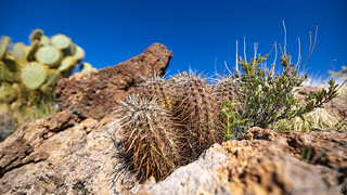
That barrel cactus is amazing, the size is by far the biggest one I have ever seen. Are you noticing any super bloom? I will be interested in what Grasmere will bring next week. I am sure the river and streams will be flowing high and no crossing the river for a few months.
Thanks again Dan!
As always, thank you for the thoughtful comments Kenny, they are much appreciated!
I too am curious about Grasmere. I'll shoot you a separate email about that. ?
I'm so grateful for you having taken the time to give me a "desert fix"! That kind of hiking is no longer part of my repertoire, and as an artist, I'm thrilled to see all of those petroglyphs.
I'm so glad you enjoyed the "desert fix" Jan! It's always nice to hear when the stories are enjoyed, especially when it helps to get someone "out there" who isn't able to on their own any longer. (Oh, but the stories I bet you have from when you could! ?) Anyway, if you liked this first part of the story, I think you'll very much enjoy what's coming over the next several posts. This was an amazing trip as far as rock art and the beauty of Utah goes! Thanks again for your kind words, keep them coming as you enjoy future stories!
It's very kind of you to take the time to reply. I'll definitely be watching for more!