
With the Tacoma stored in Las Vegas and a 6:00am flight, we headed out the door a little after 4:00am for a 45-minute light rail ride to the airport. In high spirits - the trip south would only take two-and-a-half hours - our discussion focused on what hike we should tackle when we arrived in Death Valley a few minutes after lunchtime.
Train tickets purchased, we headed to the platform to wait for the next train. Unfortunately, we'd neglected to research when the trains started running, and only as we were waiting did we discover that the first train wouldn't depart until 5:30am, getting us to the airport a few minutes after our flight was airborne.

Now in a mad dash, we decided that the most expedient option was to walk 10 minutes to get home, and then find some off-airport parking as we drove to the airport. Ultimately that all worked out, but we learned that the earliest flights - which seem great because they allow for more exploration on the first day - aren't really the most convenient. Rather, 8:00am flights allow for both running trains and more sleep.
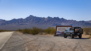
Entering the park via a new-to-us route - CA-178 - we marveled at the clear skies and vibrant landscape as we descended Jubilee Pass and almost immediately left pavement on West Side Road.


Previously on Left Behind, we'd started at the north end of West Side Road and worked our way south, heading up into the Panamints at each drivable canyon. This time we decided to start at the south end, and soon we found ourselves once again climbing the alluvial fans towards the Queen of Sheba Lead Mine.
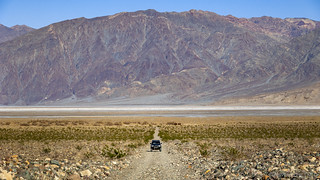
Not wanting to waste time on turns, this was one of - if not the - straightest roads up an alluvial fan that we've ever driven. However, straight didn't mean smooth, and our pace slowed significantly - at least until we aired down - for the 5-mile ascent.
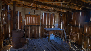
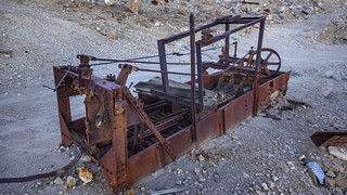
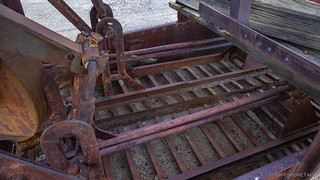
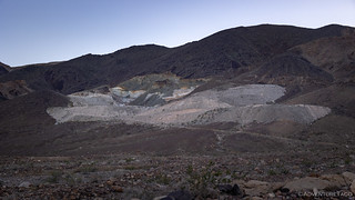
At the top, we were both a little surprised to see quite a bit of old mining paraphernalia still strewn about. A couple of cabins - neither in great shape, but also not dilapidated - two large ore bins, mill and separating tanks, dozens of tunnels, and a long ore chute decorated the hillside. We'd only left home nine hours earlier and we were already exploring!


One of the most productive lead mines in the park, the Queen of Sheba produced about 5,000,000 lbs of lead, 100,000 oz of silver, 1,500 oz of gold, and 146,000 lbs of copper. It was first discovered in the late 1800s by prospectors who were looking for gold in the area. The mine was operated intermittently until the 1970s, when it was finally abandoned. The mine is named after the Queen of Sheba, a legendary ruler of the ancient kingdom of Saba (or Sheba) in southwestern Arabia, who was famous for her wealth and trade with King Solomon of Israel."What is the history of the Queen of Sheba Lead Mine near galena canyon?"
as answered by ChatGPT via Bing
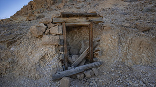
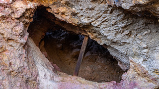
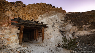
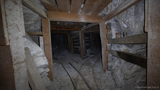
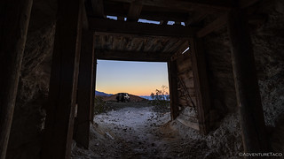
Just below the ore bins, the foundation of an old mill didn't seem all that interesting, so we headed up the hill to investigate the many workings that punched their way into the mountain. In fact, there were so many, that we each chose the ones that seemed most interesting to us, and passed each other somewhere in the middle of our explorations.


Going into the adits wasn't the only great thing about the Queen of Sheba Mine. The views across the valley floor - to the Black Mountains - every time I left the darkness for light, were amazing. I'm sure the miners didn't enjoy them quite as much given the hard labor that they endured while on site, but as someone who was just visiting, I couldn't help but catch my breath each time I looked east.


Eventually having investigated the most interesting diggings on the immediate hillside, we regrouped and - showing a little restraint this time - headed off together to check out a neat looking ore chute that clung to the hillside a quarter mile to our north.


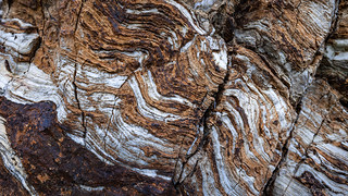
Knowing that we still had a ways to go before finding camp, and with only an hour of daylight remaining, we pulled ourselves away from what could have kept us entertained well into the evening and headed back towards the truck. Of course, we couldn't help ourselves but to stop a few times to wonder about this or that piece of equipment, or ogle an interesting bit of geology.

Heading back down the Queen of Sheba road - no steering required - we had only 50-feet or so of West Side Road to traverse before turning back up the alluvial fan towards Galena Canyon. Surely - at one time - there must have been a road between these two clusters of mines, given their proximity on the edge of the Panamints. Alas, there's nothing on the Death Valley National Park maps connecting them today, and since staying the trail is important if we want to retain access to these historic sites, a 10-mile round trip is necessary to cover the mile of distance between the two sites.
Not that we were in any huge rush. Or at least - no more than usual!
Galena Canyon, it turns out, is home to many mines. Initially - from looking at satellite imagery before we headed out - I was under the impression that they were simply several workings of the same mine. But - upon researching a bit more on our return - I learned that there were a series of operations here, all of them racing to pull as much talc out of the ground as possible.
The [Bonny Mine] claims were originally owned by Southern California Minerals Company of Los Angeles, whose only mining operations here occurred during 1954 to 1955, yielding approximately 2,300 tons of talc. The area was mined by dozer cuts on the surface and through adits and drifts underground. The Bonny claims were subsequently acquired and patented by Pfizer, Inc., in the 1960s and 1970s.
Since 1970 these pit and stripping operations have produced about 30,000 tons of talc, for a total value of over $1,600,000. Although there is no record of ore production for 1975, the site was being worked by dozers in 1977 and 1978. In January 1978, Pfizer began removing waste rock overburden in order to expose additional talc, increasing production to 9,000 tons annually. Underground development was proposed to begin near the time of completion of the pit operations (1981), with 25-ton trucks hauling the ore to the company stockpile and mill at Victorville, California. Death Valley Historic Research Study
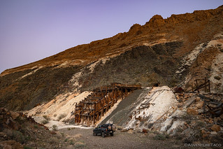
Not realizing that it was a completely separate mine, we ended up skipping the Bonny Mine entirely as we headed up a series of steep switchbacks to a pair of large steel talc ore tanks and a large adit of the Mammoth Talc Mine, only a few minutes away.
Sunset has arrived.
The Mammoth Claim Group was patented July 9, 1963, though the first underground exploratory activity took place in the late 1950s. Underground mining operations were initiated by Kennedy Minerals Company and C. K. Williams and Company and consisted of more than 1,600 feet of underground workings associated with a main shaft and raises connecting several sublevels.
A lower adit was projected below the main one in hopes of intersecting the ore body, but it failed to locate any talc. A few other smaller exploratory openings were also made, with total production during the 1960s reaching about 5,000 tons. From 1970 to 1974 the mine was idle, and then, in mid-1975 and early 1976 Pfizer, Inc., which had gained control of the property, sporadically activated the mine by mining and shipping small test loads procured in the vicinity of the old main adit by means of an open cut or pit. About 200 tons of ore have been produced since, with a resulting total surface disturbance to the entire area of 3.75 acres.Death Valley Historic Research Study


Continuing up the canyon - now feeling a bit of pressure to find a place to call home for the night - we passed a couple of cabins. Unable to keep my eye on the proverbial ball, I hopped out for a quick look-around.
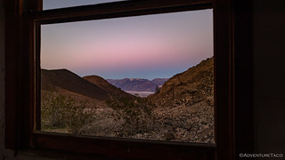
"Knowing"* that we'd spend more time here the next day - and given that it's always nicer to find camp when it's still light out - I ducked through the lower panel of the screenless screen door and jumped into the truck. The road up the canyon forked at this point, and we had a decision to make.
* I'm always saying to anyone who will listen that it's always a good idea to take pictures, even if you think that they will be "better" later - when you're coming back the other direction on a hike, or whatever - because you really just never know. The weather can change, you could find a different route back, or it might just take a lot longer to return, and it could be dark.
Why I can't follow my own advice is just beyond me.
For no reason other than luck, we decided to make our way up the left fork of the road. At the next fork, we picked the right. Somehow, we ended up at what I now know to be the White Eagle Claim of the Death Valley Mine. At the time, it was just a bad-ass mining operation that I couldn't wait to explore the following morning.
Happy to have found a spot that was both interesting as well as sheltered from any winds - and also at the end of the road, which would afford us privacy, though we never saw another person on our entire time in the Panamints - it was time to level out the truck and fill our bellies with dinner.
Together, these are usually a 30 minute operation for us.
Today, not so much.
For some reason, it took us more than half-an-hour just to build the piles of rocks that would level the truck. Sure, the wash was a little more inclined than most of our sites - so the rock piles had to be a bit taller - but it wasn't anything extraordinary. In the end though, we got it functionally perfect and rewarded ourselves with a no-cook meal of Jimmy John's sandwiches and a couple little madeline-brownie cakes that @mrs.turbodb had picked up at the grocery store when we'd provisioned in Las Vegas.
Anyway, it was too dark to take photos of the leveling carnage, but I snapped a few the next morning. Please, feast your eyes on our years of experience.


Our bellies happier, it was still a little early to call it a night, so we spent an hour or so reading while I waited for it to get a bit darker so that I could set up a shot of the surroundings.

In the end, I think the shot came out nice, but I clearly need to up my game given some of what I've seen Mike @mk5 put together. That, and I need one more headlamp, so I'm not tripping over old mining debris as I move from one light to the other, for minor adjustments.
It was 9:00pm when we climbed up into the tent, temperatures in the mid-40s °F and no wind to speak of. It'd been a fabulous first day - so much nicer than our usual 20-hour slog. Yet - as cool as it'd been - it was the plan for the next day that I'd been looking forward to for three months; now, mere hours away.


Great stuff as usual.
Thanks Greg! Had a great time out there, discovering something that's always been so close and yet totally unknown to us!
Nice!
Really like the night picture. Just enough lights!
Another wonderful trip log! You're bringing a picture of Death Valley to life that many would have not seen if not for your posts. I've been to the Park over 25 times and still discover new interesting facets, many thanks to you. Glad you were able to adapt-improvise and overcome. Cheers, ralph
Good work.
I believe you have made a long needed suggested improvement to the SPA Forum.
If you find yourself passing through Pahrump, PM me and maybe we can hook-up.
We will be at SPW third week of April in RV park; motorhome and jeep.
Pahrump George
Thanks George, glad you've enjoyed the stories, and I hope that you find additional ones here that I won't be posting to SPA, since they aren't specifically SV related. I'll definitely keep you mind if I'm headed through Pahrump!