
Having replaced the transfer case that had given up the ghost on my previous trip to Death Valley, the new year and lots of rain at home was enough to get us back on the road and headed south again. It was a long drive - this time along a different route that would bring us in the west side of the park rather than the east - but we powered through and by 3:30am the following morning, we were setting up camp in Panamint Valley along the Nadeau Trail. Sleep never felt so good.

Waking up for sunrise didn't even cross our minds. I set my alarm for 9:00am after our long drive and we were awoken just before that by F-18s screaming overhead.
Exploring Death Valley during the winter months is usually a good choice. Given the wintery-cold temps and snow elsewhere, the relatively cooler - but still pleasantly warm at 60-75°F - days in the desert are a welcome break from the dreary days in the Pacific Northwest.
It was with this in mind that I planned this trip to the southwestern Panamint Mountains. We'd explore an area I'd discovered the last time I was in the area - along the Pleasant Canyon-to-South Park loop - but that we'd had to rush through in order to make it to camp in time. This time, things would be different. Instead of spending four hours, we'd spend two days, hopefully doing the plethora of spur roads and abandoned mines, justice.
The only thing I didn't factor in was... winter. 

Hmm, the plan had been to spend all of our time up there... but not in that snow!
The loop through Pleasant Canyon and South Park tops out around 8,500' and judging from the landmarks we could see, snow seemed to start at 5,500' or so, and was full coverage by a little over 6,000'. That would mean slippery roads and a lot more effort needed to explore the mines - not to mention very cold days and nights - so we knew the plan was going to have to change. The question was, how?
For now, we delayed the decision and decided to explore a couple of the canyons at lower elevations.
There's always something cool to look at in Ballarat as we air down.

Heading up into ███████ Canyon.

Don't let this happen to you.
I'd only discovered ███████ Canyon by looking at satellite imagery. A road and what looked like some structures and mining activity piqued my interest, and so here we were on another adventure. And, as we drive up through the winding wash, the geology didn't disappoint!

I may have been accused of parking too close to this huge chunk of rock that had broken off the side of the wash. Personally, I'd say we weren't close enough!
At the end of the road, the ███████ Mine - hence the name of the canyon - sat perched with a splendid view of the valley and was clearly still active. Just outside the park, my map showed that the entire area is managed by the Bureau of Land Management (BLM), but my guess is that the mine itself is privately owned. To show our respect, we left the truck below the site and proceeded on foot, several hunting cameras clicking away as we walked by.

A tidy camp.

Through a window.

An old lumber stockpile near the entrance to the camp.
From a mining perspective there wasn't a ton to see - this is clearly a small operation - and we wanted to be respectful of the current owner - so we didn't go poking around too much before heading back to the Tacoma. We did however see two things that really put a smile on our faces.

In the trailer, a fun map of Death Valley from 1948 was featured prominently. Deserts - and the people that love them - are a little funky, and this map captures that well.

Loved this sign. And it's true, the outhouse was in pristine condition.
I'd have given it ⭐⭐⭐⭐⭐ myself!
And so, less than half an hour after we arrived, we were headed back down the canyon toward Panamint Valley, the fanglomerate walls of the wash towering high over our heads. We had one more canyon to visit before we were going to have to make a decision about what to do on the remainder of the trip, so like any good explorers, we continued to procrastinate our decision.

A mountain, eroded.
As we headed south on Wingate Road, we had our sights set on ██████ Canyon. Just north of Goler Wash, it was a canyon I'd driven by several times without exploring, and I'd recently learned that there were some really cool mine workings at the end of the road.
But, as is so often the case, ██████ Canyon would have to wait just a little while longer. Because - as we headed south - we passed a turn-off to the Goldbug Mine and decided that while we weren't going to attempt the entire Pleasant Canyon loop, we should try to check out this mine that is just off the loop but at a lower elevation.

The Goldbug Mine is - unfortunately - gated!

With our detour having been short, we were soon headed south again along Wingate Road, the wet lake bed of southern Panamint Valley a testament to the moisture that'd put the kibosh on what had been our main attraction.
It was 12:30pm when we turned off the main road and headed east again, climbing the alluvial fan toward ██████ Canyon. Even before we entered the canyon narrows, the colorful rock was enticing, drawing us in.

It was as though white frosting had been dripped over the chocolate mountains of the southern Panamints.

A kaleidoscope of color.
Upon entering ██████ Canyon, the road immediately becomes more challenging as it is hemmed in - on both sides - by soaring rock walls and steeply sloped taluses.
The geology of ██████ Canyon is particularly varied and interesting. For the first 0.8 mile, the gorge winds through Triassic granodiorite, then late Precambrian dolomite and quartzite. Past the pronounced left U-bend, where the wash broadens, and for about 0.3 mile, the road crosses the Kingston Peak Formation, a complex mélange from the Proterozoic era that has gained notoriety for the compelling story it tells. Its main constituent is so distinctive that it's hard to miss: a gray rock filled with paler, inch-size inclusions, oblong and roughly parallel, appropriately named stretched-pebble conglomerate. Hiking Western Death Valley National Park

Entering the canyon. Imposing, and yet even more exciting.

This road is not heavily travelled and requires a good bit of skill and plenty of armor.

Stretched-pebble conglomerate of the Kingston Peak Formation.
It took us nearly an hour to cover the mile-and-a-half-long road to the █████████ Mine. Where most of the park recommends high clearance 4WD on nearly all dirt roads, I've found that there are few places where it is actually required. This - certainly - is one of those places. Even with it, careful line choice and a fair bit of skill were needed to navigate several more difficult sections. In the end, of course, our persistence was rewarded - the lower terminal of an aerial jig-backed tramway.
As with the ███████ Mine mentioned earlier in this story, this site is not part of Death Valley National Park, but is private property surrounded by BLM land. Please respect them both as you would your own property.

We have arrived - and I knew immediately that something was missing!
In addition to the tramway - which was what I'd most been looking forward to - I'd expected that we'd find a small mining camp situated just across the wash. Built in the shadows to combat the scorching summer temperatures, a delightful cabin and old RV trailer once provided shelter for miners and now a respite for present-day explorers. Alas, no longer.

All that remained of the cabin and trailer were charcoal remnants. With so little left, the fire here must have been hot, and appeared to have burned in the last 12 months.
Anyone with details, I'd love to hear what happened. I reached out to the NPS and they were unaware that the cabin had burned.
As @mrs.turbodb set about making lunch - we were both hungry as it was now nearly 2:00pm - I poked around the fascinating terminal of the lower tramway. This wouldn't be the biggest highlight of this place, but it was one of the coolest terminals I've seen, and a close second for sure!

A magnificent structure built on the northern side of the wash.

The lower tramway terminal also served as an ore chute for loading trucks.

Triple-chute. And ladder. I feel like I've played this game before... 
Anchored to a rock face with 4-inch chains, the tramway is a one-of-a-kind structure, or at least the only one of its type that I've seen in my explorations to date. The ladder climbs to a catwalk which skirts the top of the three-chute ore bin, allowing access to the 12-foot steel wheel that guided the thick tramway cable. The original engine of this tramway was gravity: the descending ore-filled bucket simply pulled the empty bucket back up.

Four-inch links.

The magnificent steel wheel.


The path of the tramway and the sole remaining ore bucket.
It was at this point that I was called back down from my exploration for lunch - an intermission I was happy to oblige - which consisted of tuna sandwiches and salty potato chips. As we ate, I related the details of the tramway and talked through the plan for after lunch - one that I suspected would lead us to the highlight of our day.
The plan - in as much as it was one - was to "hike" the steep canyon walls to follow the cable of the tramway. More of a scramble, we would gain over 550 feet of elevation in less than half a mile. My hope though was that what we would find at the top would be worth it.

We gained elevation quickly.

Along the way, a young barrel cactus seemingly grew directly out of the stone.

Abandoned homes of the local residents littered the ground.
Eventually of course, we made it. And as I'd hoped, we were in a candy store. The mining complex above the terminal is small but uncommonly intricate. A rail track - part of which soars across a trestle bridge - winds through a channel blasted through a ridge to reach the upper tramway. The slope here - steeper than 50° in some places - was so steep that the track is built on two levels, with the upper level emptying material into an ore chute that would deliver it to the level below.

I think my favorite mining paraphernalia to find are old rail trestles.

What men do for a little bit of gold.

@mrs.turbodb was happy to stay outside. The tunnel's long drift exploited gold-bearing smoky quartz which was transported along down the tramway and then trucked out of the canyon.
In addition to the workings, the railway terminated in a well-preserved upper terminal. A similar contraption to the terminal at the bottom, this tower of sun-cured lumber and rust-coated steel is anchored in place by hefty cables and shares a similar 12-foot wheel. Here though, a newer Nissan engine was a more recent addition, used by the present owner to give the aging tramway a speed boost.

This look like a zip-line to anyone else?

I can only imagine what it took to transport all this material up the mountain. This was not a profession for the lazy.

A little help for the aging structure, it was fun to see that the gear shift still worked flawlessly and the the internal workings were fully greased and oiled. With a little care and a new battery, it may have fired right up!
Having explored the site to our hearts' content, we picked our way down the hillside and piled into the Tacoma for an exciting trip back down the canyon. We'd decided on a plan during our descent and given the time - nearly 4:00pm already - we needed to make good time if we were to get to camp before dark.
Not that we really stood a chance at that!

Back into the colorful canyon.

Even a 10-by-10-foot area was alive with color. Inclusions, faults, and the magic of our planet were on full display!

A bit of fun driving along the way.
We reached the mouth of ██████ Canyon half an hour later. As we exited the mouth, we were greeted by the local riff-raff, looking a bit shaggy in their winter coats and already munching on dinner as they lifted their heads to bid us farewell.
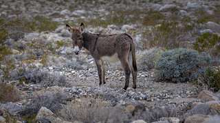
"His name was Steve." -Mike @mk5

His wife, Sara.

Bye Steve and Sara.
We arrived at our designated camp location well after dark. We'd backtracked an hour or so to get there, but in the end, it would be the least of our detours on this trip as we searched out low(er)-land locations to keep us more comfortable while the higher elevations were covered in snow.
Prepping dinner just after 6:30pm, we were just sitting down to eat when @mrs.turbodb exclaimed that there was a cat in our camp site. "A cat?" I asked, a little bewildered, since there aren't a lot of cats in the park. Regardless, I grabbed my camera and flashlight, because - whatever it was - I wanted to snap a photo.

"You're going to take my picture ehh?" says the fox. "Well then, I'm going to pee on your camp site."
It was a kit fox. Not uncommon in the park, but the first one I've seen in all my trips, and so exciting for us both - a great way to end our first day on the trail. We'd head to bed an hour or so later, ready to get up early in the morning for our first hike of the day. A hike across the desert - one that would turn into a race - but not against each other.


Sweet! We had a kit fox come into our camp in Panamint Valley in November. Our cat, Elsie, was off leash and chased it ( probably thinking it was another cat). I called her back, and no one got hurt. Kit Foxes are adorable! We also went up Coyote canyon, but on foot. Will definitely go back and explore those mine ruins.
Looks like you hit the Jackpot !
Was definitely a fun time!