If there was a drawback to our primo camp site, it was that being in a valley meant that the sun didn't reach our position until sometime around 9:30am, two hours after sunrise. Of course, at that point, it was once again beautiful and warm, Dan @drr taking full advantage as he ate breakfast in front of his GFC. Within about 15 minutes I'd changed into shorts and a t-shirt, it was so pleasant.


The larger the group, the harder it is to get going in the morning, and with six trucks and nine people, we finally rolled out of camp just before lunch time - 10:45am or so - and headed up the aptly-named Paradise Divide Road towards Schofield Pass.


Switchbacks and smooth gravel allowed us to gain elevation quickly, and before long we found ourselves at the apex of Paradise Divide, the road dropping down into Paradise Basin - Mount Baldy rising up to our east.


Through the day, the CB troubles that had popped up continued to make themselves known - or rather, one of them did. Steve @woodnick was chatting along without issue, having ferreted out the correct frequencies on his Ham radio. Mike @Digiratus seemed to have no problem hearing either. But my setup seemed worse than ever. Both reception and transmission only worked over extremely short distances, and it made for a quiet trip as I brought up the rear over Schofield pass and past the historic town of Schofield.


We didn't stop at Schofield - a cute little cluster of houses in the Schofield Park - Monte @Blackdawg mentioning that we'd stop by in the afternoon as we returned from the day's adventure - though I couldn't help but to snap a photo of one of the well-kept houses nestled into the trees.

Head northwest at this point, the terrain varied between evergreen forest and grassy valley as we made our way towards what would prove to be the most treacherous trail we'd encountered so far (though to be fair - at this point, that's not saying much): Devil's Punchbowl.
In stark contrast to what had been a dusty trail weaving in and out of the woods, as the trail approached the punchbowl, it became a narrow shelf road, with a steep drop-off to the creek below. This in itself wouldn't have been much of an issue, but as we looked down the trail, a couple of fallen rocks were enough to get us out of our trucks to check them out before continuing.

As usual, photos make this look tame.
A bit of scouting by Monte, Mark @IDTrucks and I, showed that we'd likely be just fine with our band of 1st gen Tacomas - but one of the rock slides was going to mean an extremely tight turn, very close to the edge of the trail, for Steve in his wider-and-longer 2nd gen Tacoma. As such - and because he and Megan had to be back in Crested Butte by 4:00pm anyway for an online appointment - they decided that this was the spot where they'd turn around for the day.
The rest of us proceeded cautiously. Monte and Devin @MissBlackdawg first.

This seemed like a tight squeeze at the time.

Past the second obstacle.
Then Mike took his turn, followed by Mark and Dan.

Finally, after letting a group of six ATVs by, I took off down the trail after the group, the experience reminding me of the shelf road leading to Indian Hot Springs in Idaho, though I still believe that road to be sketchier than this one.


As I neared the bottom, there were the other trucks, all waiting patiently - or was it anticipatorily? - for me to pop around the final corner.

The view up the trail from the bottom was perhaps more indicative of the terrain than the view from the top, down. Here, from Devil's Punchbowl, it was easy to see how much elevation was quickly lost on the ledge road, as it followed the creek down to the valley below.

All back together, we continued down what was now a rocky shelf road following the creek for another half-mile or so, the going slow as we let the aired down tires and suspension do their work.

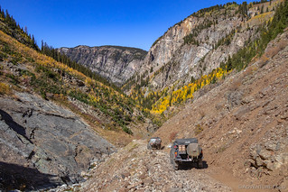

That half-mile took 15 minutes to traverse, at which point we turned back into the forest and the golden hue cast by the fall aspen. Almost immediately, on a narrow section of trail, we had oncoming traffic. What could have been very interesting turned out to be quickly solved, as the 4Runner we were passing climbed up the side of the road in order to let us by.


From here, the trail once again wove in and out of the woods - now following the North Fork of the Crystal River as we made our way into the second loop of the figure eight we were traversing - a loop that would take us through Lead King Basin.


Having spent quite a bit of time scouting and navigating Devil's Punchbowl, we found a beautiful spot in the bottom of the basin to have lunch, the white granite of Hagerman Peak rising in the distance to the north.

It was during this lunch stop that I finally resolved to figure out the problem with my CB radio. After scarfing down my food, I borrowed Mike's SWR meter and set about testing my antenna - my assumption being that I'd either need to adjust it's tip, or that my actual Uniden Pro 520XL CB Radio was bad.
A good SWR reading is right around 1.1 - at least in my experience - and you can imagine my non-surprise after a couple days of terrible communications when Mike's meter told me that my setup was currently giving an SWR of 10! Some quick troubleshooting showed that adjusting the tip on my FireStik antenna had no affect on the reading, but that swapping in Mike's antenna dropped it right back down into the 1.1 range. So, the problem wasn't the radio - it was the antenna!
And that meant that - for now at least - there was nothing I could do about it.
We packed up lunch and headed out - with Mike assuring me that anything vital would be relayed via Ham to me at the rear of the pack. Which was just fine by me - that is after-all, part of the reason we have redundant communication systems.


A series of switchbacks led us by the top of Arkansas Mountain, the views getting better and better as we climbed. These still weren't like the views we'd seen at some of the high passes last year, but it was nice to be out of the trees and getting a taste - even a little one - of some of the altitudes that Colorado has to offer.


Nearing the halfway point of our loop, the trail passed through one of several avalanche chutes that we'd cross on this trip - this one a bit more recent than some of the others.

It was at about this point that we stopped for a quick pow-wow about what to do next. At 3:30pm in the afternoon, we were running a mere two-and-a-half-hours behind schedule and had to make a call as to whether we'd make the 4-mile roundtrip from the top of the loop to our original destination - the town of Marble - or whether we'd simply continue the loop back towards town to meet up with Steve and Megan who'd turned around earlier.

Two peas in a pod.

Are we having fun yet? Apparently, yes.
Ultimately, the "why would we drive 4 miles just to see a town," crowd won out, and it was back along the other side of the figure-eight-shaped loop for our gang of five - the roads bumpy and the travel slower than ever due to a sudden increase in traffic moving both directions.
At times, we'd find ourselves at a complete standstill as motorists with much less experience tried to negotiate passing on narrow roads. In one such situation, Monte ripped the NMO roof mount for his Ham antenna completely out of his roof, as he tried to navigate the side of the trail. Through it all, Mark and Emily took the opportunity to gaze lovingly into each others eyes.

That's not to say there wasn't some beautiful scenery along the way - Lizard Lake and Mineral Point were two highlights - as we made our way east towards the historic town of Crystal.

Lizard Lake.

Mineral Point. Despite a top speed of 2 mph for the previous 30 minutes (dictated by a Rav4 in front of our group) I was yelled at by a UTV behind us when I stopped for this photo. Gotta love the UTVs.
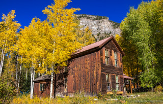
Finally - and I do mean finally - we reached the cause of all the hoopla. As we pulled into Crystal, there were people everywhere. The main attraction was clearly an old mill perched on the Crystal River - the road so packed with people as to become nearly undrivable at this point.

Crystal - as with many mining communities - began in the 1860s when miners started working the area. However, the location was so difficult to access that it took another twenty years for things to start booming. Officially established in 1881, Crystal City boomed as a mining - of primarily silver, lead, and zinc - camp for several decades with an average population of around 500. With a post office, newspaper, pool hall, the Crystal Club (a popular and exclusive men's club), barber shop, saloons, and hotels, it was a happening place - though ore transport continued to be a hinderance given the road system to and from the town. As with many early mining towns, Crystal's existence was relatively short-lived - by 1917 it was all but abandoned, despite the construction of the picturesque Crystal Mill that is the main attraction today. (Wikipedia)
Today, Crystal does sport a few residents - folks who have taken over care for several of the old buildings in town - but even they reside there only during summer, when the weather is nice and the colors are nothing less than stunning.
This short pit stop also proved a worthy place for Monte to perform a bit of work on Igor. With new rear leaf springs and u-bolts this trip, he'd been meaning to snug them up for the last couple of days - forgetting to do so each time we stopped - something interesting always distracting from the job. Naturally, the job took one socket and at least three cameras, with Dan, myself, and Mike lined up for the shot.
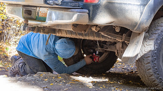
The work being done.
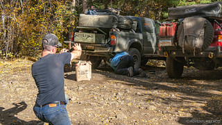
Like construction workers, there were always several of us supervising and capturing the progress. 
As quickly as we could, we were back on the road - the top part of our loop now complete, and traffic once again light as we headed back towards Devil's Punchbowl - the short connecting trail to the bottom of our figure-eight. Even without traffic, the going was slow here - the terrain dictating our speed as we picked our way over the rocks alongside the creek.


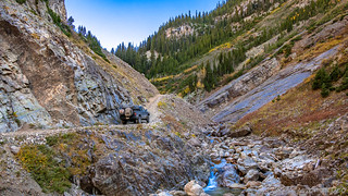
As we reached the punchbowl and the narrow shelf road that would allow no opportunity to pass should we encounter oncoming traffic, I ran ahead with my handheld Ham radio to ensure that no one else was coming. The coast clear, I radioed down for the rest of the gang to follow, each of them making easy work of the narrow, rocky road as I trotted back down to my truck - which I'd left perched on the bridge - to do the same.


From Devil's Punchbowl, the trip back over Schofield Pass towards Crested Butte was a quick one. We didn't - as I'd suspected earlier in the day - stop to check out the historic town of Schofield on our way back, making me glad I'd taken a few seconds to snap a picture the first time through. Instead, with the sun getting lower and lower on the horizon - and with the knowledge that Monte's parents were likely waiting for us - we picked up our speeds through some of the dustiest terrain we'd see all trip, the entirety of Gothic Road seemingly made of silt.
It was here - as we were cruising along as fast as we could, in near white-out conditions - that a mountain biker began to pass us on the road. Naturally, this caught us all by surprise, and being at the back of the pack, I called it out as soon as I saw him in my peripheral vision. This guy was crazy - with no mask or eye protection, he was passing in conditions that could spell certain death should anything go wrong.
Luckily it didn't, and fifteen miles later the dust died down - finally allowing us some colorful views across the valley and to the fall-time show that was on display.

From there, it wasn't long until we reached Crested Butte - it's main street downtown abuzz with activity, and looking as cute as a button.
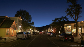
We found a nice pizza spot where we could eat outdoors, and with temps dropping we bundled up to enjoy a variety of wood-fired pizzas as we shared the stories of the day.
Stomachs full, it was 7:30pm - and fully dark - when we pulled out of town and set of in search of our camp site for the night. We knew it'd be somewhere just south of town, on the Pearl Pass Road - our first destination of the following day - and that meant a couple miles of highway travel before turning off onto dirt.
And it was there, in those few miles - at a reasonably slow speed of 35mph - that another deer decided it'd be a bad idea to run out in front of the truck. I clipped it - just barely - with the front corner of the bumper, surely more of a problem for the deer than it was for the Tacoma.

Luckily, these little hairs were the only indication of the impact. @RelentlessFab bumper for the win - again!
After a quick inspection, we continued on towards camp, ultimately finding a tiny little spot that we packed into like sardines - quickly unfurling our tents and huddling around Mike's propane fire ring for a couple more hours of truck talk before bed.
It'd been a long day, and I for one - with the deer incident - was glad it was over. Tomorrow would bring Pearl Pass - our first significant pass of the trip, and that was something I was looking forward to; more than even I knew at the time.


Damn you and your cliffhangers! Great job as always, looking forward to the rest.
??
Have you see the guy on the dirt bike that was a little too thirsty for punch?
https://www.youtube.com/watch?v=zlb8ic6ivcg
OMG, I had never see this video until now.
https://www.youtube.com/watch?v=6pJCZhkk6Zg
I really want to do this run, looks epic!