
The Eastern Sierra.
I don't know if they are less well known, harder to get to, or I was just oblivious, but while I've driven past the majestic peaks numerous times - on my way to and from Death Valley - I've never really taken the time to explore the mountain range that boasts the tallest peak (Mt. Whitney, at 14,505 feet) in the contiguous United States.
But, over the last few years - as I've ventured into the Volcanic Tablelands, and here and there within the Owens Valley - I've reveled in the rocky faces and snowy peaks. Now, finally, we'd get a chance to explore - climbing to elevations of more than 12,000 feet - as we lake hop in the Eastern Sierra.
As always, the first day was a long drive down from Washington, and it was a little after 2:00am the following morning when we found our way to the end of a dirt road outside of Big Pine. Near our jumping off point to access Coyote Flat, we quickly pitched the tent and climbed into bed.
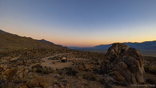


By the time we actually got up - I was quickly back to bed after these shots - we'd gotten about seven hours of sleep - not a full night, but also not bad for having covered so much ground the day before.
Already it was starting to warm up, and with afternoon temperatures forecast for the upper 90s °F in the area, we were glad to be headed for higher elevations; as it was, we were already breaking a sweat as the tent was stowed and the sun beamed down on the distant Owens Valley Radio Observatory.

Everything packed up, and breakfastless - we'd decided to try our trail-mix-for-breakfast-strategy again - we pointed the Tacoma west and began the climb from 4500' to more than 10,300' in just under eight miles. Needless to say it was steep, and I'd heard plenty of chatter about the road to Coyote Flat from Big Pine, so I let @mrs.turbodb know that there was a slight chance we'd be turning around and accessing the area via the "normal" route, from Bishop.


I don't know exactly what to call the hills immediately west of Big Pine, but their composition seems to be significantly different than that of the Sierra just a bit further west. More like the composition of Alabama Hills or Buttermilk Boulders - a yellowish granite covered with high-desert shrubs - I really enjoyed the trail as it wound through the outcroppings, glancing back from time to time at the Inyos behind us.


As we gained elevation, the terrain began to change. Not in the Inyo Mountains, this was still the Inyo National Forest, and slowly trees began to dot the landscape. They were sparse to be sure, but their green needles were a nice contrast to the otherwise-very-dry-looking hillsides.


With all the stopping to admire views and take photos - something that my passenger is quite patient about, and had prepared for by bringing her Kindle loaded with Dune House of Harkonnen - our eight-mile, 6,000' ascent, took the better part of two hours. Of that, the trail seemed in reasonably good condition - though I recognize that difficulty is different for every driver - with only one section containing large enough rocks that some careful line choice was necessary.

Eventually of course, we crested the ridge. Rather than press forward towards the views that'd been so tantalizing for the last 30 minutes or so, we made nearly a complete u-turn towards an overlook I'd noted in my route planning, and a spot I'd thought might make a good camp area... had we arrived at a completely different time of day. Still, no matter what time of day one passes along this route, spending a few minutes to soak in the surroundings is time well spent.


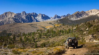
With that, we finally dropped down into the Coyote Flat area. This high meadow - at almost exactly 10,000-feet - must be spectacular in spring, with green grass and wildflowers poking up through the last of the winter snow. And there, rising out of the far side of the meadow, the terrain began its transition from dusty desert to rainbow granite, as a few peaks seemed to rise out of the flats themselves!


Having reached the namesake of our trip, we had several choices in how to proceed. I suppose the most boring thing to do would have been to continue along the loop, exiting Coyote Flat at Bishop, but with a ton of roads to investigate, there was no way we were going to bail just yet. Instead, I hoped we'd visit almost all the trails in the area, oscillating between 9,000 and 12,000 feet, wandering on foot from time to time.
Having come in from the southeast, that's where we'd start - exploring the █████ Creek area - before heading further north and west.

Climbing back up from the creek, we followed one road after another - each one winding up into the valleys and folds of the ridges above - eventually discovering a perfectly shady spot for lunch and then stumbling upon the ██████ Cabin as we looked for an alternate route back to the main loop. Gotta love dumb luck!


Eventually, we tore ourselves away from the cabin and set our sights on one of the more well-known destinations that Coyote Flat has to offer: Funnel Lake. I'd chatted with a few folks - who I thought might have pointers on the area - prior to our departure, and without fail they all recommended staying as far away from Funnel Lake as possible. Largely this recommendation seemed to boil down to overcrowding, and I hoped that our Thursday arrival would significantly reduce the chances of running into a dozen bro-verlanders with their light bars a-blazing.
What I didn't realize from my conversations was that overpopulation isn't the only thing that makes Funnel Lake underwhelming.


Not wanting to have wasted the entire route, we walked three-quarters of the way around the lake, hoping for - perhaps - a better angle. This turned out to be an exercise in "avoiding fire rings," that lined the circumference every 10 feet or so, this place unexplainedly mobbed most of the time.
As you can imagine, we didn't linger long before mentally preparing ourselves to rattle several more teeth from our mouths on the drive out. It was time to make a beeline for something a little less... sterile.
Nearly toothless - it was a real shame that the tooth fairy wasn't real, at least we could have been rich - we finally got back on the main road and turned toward the second lake of the day. This one - Rocky Bottom Lake - would be observed from above, hopefully affording us views - both on the way to the lake as well as once we got there.


I'd wondered a bit if we would camp at Rocky Bottom Lake, but it was quite clear when we arrived that it wasn't somewhere to call home for the night. A complete lack of flat ground - and no views of the Sierra - meant we'd need to find somewhere else to set up the tent. We certainly weren't going to come all this way to camp viewless.
Luckily, I had just the spot in mind - one that would not only give us a view, but that would also afford us a short hike to one of the tallest peaks around - should we so desire - the next morning. And so, it was back down one canyon, and back up another. We were headed to The Huntchback.


It was just after 5:00pm when we arrived at the overlook that would serve as our perch for the night. At the foot of The Huntchback, and high above the aptly-named Green Lake, it was perfect. For a while, we just stood there - looking out over the lake from various vantage points, letting our eyes wander to the 12,000+ foot peaks all around.


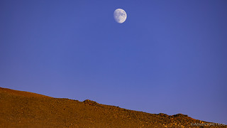
Dinner was - surprise, surprise - tacorittoes, which were prepared quickly once the Tacoma was maneuvered as close to the edge as we could muster. My hope in the positioning was to score a dramatic star trail photo once the moon set just after 2:30am, but unlike some recent long exposures on our recent Passages trip to the Olympic Peninsula that turned out to be stunning, these would be boring at best.
For the moment however - with temperatures in the mid-60s °F, a light breeze, and the sky threatening to fade through the most beautiful purple hues above us - we were both ready to eat dinner, enjoy the sunset light show, and then catch up on some of the sleep we'd missed the previous night.


For a long time, I always looked forward to those last few minutes before the sun dropped to the horizon. Oranges, reds, and yellows juxtaposed against a blue sky, once gray clouds now fiery with delight.
It wasn't until - as I recall - a trip with Mike @Digiratus (and Monte @Blackdawg) to Alstrom Point that I realized an even better time is the five-minute window about 20 minutes after the sun has dropped below the horizon. Mike called it the magic hour - which I'd heard before - and went on to verbalize the fact that there was still enough light (usually in amazing hues to boot) to photograph, but that one could do so without those pesky contrasting shadows, making for some fantastic compositions.
Since then, this has been the time I look forward to. (And it turns out there is a similar time before sunrise.)

Getting on a bit in the fall, it was still early as the light faded to our west, so we sat for an hour or so - knitting and reading and copying photos from the camera to laptop - before climbing up into the tent for the sleep we'd missed out on the night before.

We'd covered a lot of ground on this first day, and I wondered if we had enough to keep us busy for the rest of the time. We did - of course - soon discovering that we may have bitten off a bit more than we could chew.


Are you aware of the airstrip that the government put up in thre Flats during WWII?
I wasn't aware of it before we were up there, but as we headed across the flat, I noticed a long, narrow strip that was fenced on both sides. I remarked to @mrs.turbodb that it was probably a landing strip. I had no idea it was WWII era, and from the US Government. That's a pretty cool detail. Do you have any more info on it? I'd love to read up on the history. ?
As always, a great read . I feel lucky that the eastern Sierra is only a seven hour drive for me.
Thanks Greg! Having grown up in the Bay Area, I'm always (now) thinking how lucky I was to only be four hours away from "the mountains." It's a bit longer for me now that I really appreciate them, but who knows - maybe one day I'll be closer once again! There will always be plenty more to explore. ?
I’m sure you are familiar with Milton lake. I spend a good amount of time there camped right next to the lake with my fishing pontoon. Always seem to get lucky to get one of the two spots at the west end of the lake.
Another great trip report. Thank you for taking us all along with you.
I have a 99 F350 crew cab long bed. It is well equipped and I've been been offroading for 35 yrs. I have driven to coyote flats from the Bishop side. I haven't read enough about whether it's doable in my truck from the Big Pine side. What do you think?
Thanks Jack, always a pleasure to have folks along! As far as the F350 goes... that's going to be a big truck to get through there. The reality is that with 35 years of experience, you can probably make it. There'll be some really tight spots, and you may use the skids in a few places with the breakover and departure angles, but with the right lines and a good driver, I think it'd be possible. With that truck, I definitely wouldn't recommend it for most who have full-sized vehicles, however.
For comparison purposes, I'd consider it similar to the technical sections of Mengal Pass in Death Valley and the initial climb to Laurel Lakes (except significantly narrower).
Great info. I've done Mengal and Laurel Lakes.... But that was in my Jeep TJ, where everything seems easy and roomy.
I think I'll stick with the Bishop route in an abundance of caution. I did do, what's considered the hard rock crawling route, to get to Funnel lake. That section is just before Funnel.
I'd say the Bishop route and that hard rock route are about at the limits of what is comfortable with my truck.
Sounds good! Comparing it to Funnel, I'd say it's a bit more technical, so continuing to head up out of Bishop seems like a good call. Still, you can get the best views of the Big Pine route from the top (near Sugarloaf), so I'd definitely recommend heading over that direction just for those, even after coming up from Bishop.
I did the Goler/Mengel trip a few years ago in my Land Cruiser BJ40 and a friend followed in his F250. Mengel was pretty rough that year and he had a tough time of it. My Land Cruiser went over it like a speed bump in comparison.
Looks like you guys had a great trip. We were out in the Owyhee for a long weekend mid October and the weather couldn't have been better.
Thanks for the info on the Mengel/Goler comparison Tom. Hopefully that helps out Jack a bit.
RE Owyhee - were you out there with Otis, Mark and the American Outback (AOX3) crowd? That seemed like a cool thing that I was bummed to miss. We actually just returned from the SE Oregon area (the trip after this Sierra trip), where we explored some of the area around Hart Mountain. Was a pretty cool experience, with some really cold weather!
https://www.militarymuseum.org/CoyoteFlatsAS.html
I have spent time to the West in the Sierra. Most recently Dingleberry Lake. It's a bit of a hike from the Sabrina Lake area but stunning.
Nice! I definitely want to do more hiking in the area (later in this trip, we hiked up to - and past - Horton Lakes near Mt. Tom) and it seems like there's a ton of it to be done. So spectacular up there at elevation.
Quite a bit to see. I wish I could do the backcountry ranger thing up there. Also, I wonder about the airfield. It's listed as the highest in NA.
More wonderful photos and an informative and interesting adventure. Seeing the rocks & steep road I know my pickup would not make it on that route. Nice to see the OVRO, it's like the little brother of the huge Goldstone Complex further to the south. Having hiked/backed the eastern Sierra I can say there are tons of little lakes up there. We always went in the spring and fall to avoid all the nasty little flying insects, nice sunny days but the minute the Sun goes below the mountain tops there is frost on the tent! And unexpected storms can blow in from the west making things dangerous. We were lucky and only had to pack out in the rain once when a big storm blew in, wait too long and you might need to be rescued!
Well, now I'm going to have to look into the Goldstone Complex! I've visited ORVO and the Hat Creek Radio Observatory up in Northern California, but I'm always looking for big radios - so cool!
And I'm right there with you on the flying insects. Hate those things!
Making me wanna rush and complete my Taco to come join you on these great adventures. Superb pictures and story telling. Man, PBS is gonna get you on TV one day!!
Hahaha, you mean they'll have some documentary about how some random dude got lost in the wilderness, and no one cared... right? ?
Thanks Dan, another great trip and excellent photos, especially the nighttime shots. Interesting area, never been there and the views are spectacular.
Thanks Kenny! Definitely a cool area that I'll be back to (maybe not Coyote Flats itself, but there's lots more of the eastern Sierra to explore!)
Hey Dan,
Nice trip! I did some Wheeling/Camping up in that area in my Ole CJ5 back in the early 80's. Remember camping by a small lake that had small icebergs floating in it, LOL. Beautiful Country. I think I went out of the Bishop area. Now you Sparked my interest to go back after Winter (Pray for Snow) we Need the Water. Do you have a GPS/Topo of your Trail Run? That would be Wonderful. Cheers, Sean, San Diego, CA...
🙂
Glad you enjoyed the story so far - lots more good stuff to come (IMO at least, hahaha!)
Speaking of CJ5's, you might enjoy a short little section of this story. That Jeep is the first one I ever drove offroad. Still hope to (help) fix it up one day as a family project. We shall see.
As for a GPS/Topo - I don't have anything specific to share (you can see my approach here: https://adventuretaco.com/do-you-have-a-gpx-for-that/) but I do have a set of posts where I talk through how I go about creating my own: https://adventuretaco.com/guides/route-planning. Hope that helps, and there's always the option to just "end up in the area and explore." Sometimes, I find that to be even more fun! Cheers!
Lots of excellent information and love the photos too. By the way, I know you love your first generation Tacoma but if you were to retire it what would be your replacement 4X4 vehicle? Land Cruiser, Sequoia, 4Runner, Tacoma or a Tundra ?
Thanks Christian!
Boy, I guess I've always figured that my next truck would also be a Tacoma. Maybe by that point, and EV model...but there's the pesky range issue. The two things I really love about the 1st gen are:
My biggest "complaint" is overall comfort on the highway - I'd like something a little cushier - so from that perspective, a Land Cruiser would be the obvious choice. Or maybe it'd be nice to more easily run bigger tires...so perhaps a Jeep w/a solid front axle. But really, it'll probably be another Tacoma. And as of right now, my preference would be for a lower mileage 2nd gen, of the '12-15 variety.
What are you running in, if you don't mind sharing?
Hello Turbodb,
I had a 2002 Tacoma 4x4 DC and sold it. My wife hated it as the paint had faded, and the clear coat was peeling. It was small, especially with a child seat for our 6-year-old daughter and her friend. I live in SoCal, and my old Tacoma was my beach, mountain, trail, and house-duty pickup. I considered a Land Cruiser, but the ones I saw had rust issues as they were from the rust belt states. I looked at several 4Runners, and they were from back east too. The Sequoia was too big, and I would rather have a Land Cruiser. I decided that an SUV would not fit my needs, and I needed a pickup. It needed to do the same duties as my old Tacoma but be roomy for family and friends.
I looked at used Tundras and compared the first generation with the second generation. I preferred the first-generation Tundras as they were slightly roomier than the current Tacomas and much cheaper. I also liked the 4.7L V8 engine, and the Tundra would be an extra vehicle. However, it took me a year to find the right Tundra for the right price. Most sellers wanted too much money for their first-generation Tundras and had yet to perform routine maintenance like the timing belt and water pump. Carfax is your friend, and doing a VIN search for any recalls.
During an online search, I struck Tundra gold. I found a SoCal 2004 Tundra DC 4x4, Limited, with 200,000 miles, that all the previous owners adequately maintained. It came with a suspension upgrade, new catalytic converter, Catback exhaust, Toyo tires, new paint, new Method rims, Baja Design fog lights, Baja design ditch lights, LED headlights, and all maintenance records provided, including timing belt sparks, water pump ay 185,000 miles with all maintenance performed by a local Toyota service center. The owner was desperate to sell as he was tired of paying for gas on his Tundra as it was his daily driver to work, and he needed to buy a hybrid vehicle that he was negotiating buy. My wife and daughter saw the Tundra and loved it. I knocked off $3k from his asking price of $18k, and my timing was perfect as he just paid for the vehicle reg and new battery.
I now own a 2004 Tundra DC 4x4 Limited that my wife and daughter love and the roar of a V8 engine with a Catback exhaust is a head-turner.
Lurking, I read with interest the discussion of what could be a good future vehicle. I have been driving Nissan Xterras for over twenty years. I prefer it to any currently available pickup because of wheelbase, if nothing else. The Xterra's is 106.3"; every pickup I have checked is much longer, because because tariffs have made 2-door p/u trucks uneconomical. In my experience, wheelbase is the most important single factor in backcountryworthiness. Attack and departure angles are critical, too. Locking diffs are rarely required, but when they are, you are really glad to have them. If I were looking for a backcountry vehicle right now, I would probably settle on a 4Runner, which has a bit longer wheelbase (109.8) than an Xterra, but is significantly longer overall (190 vs 179"), hence inferior attack and departure angles.
The year 2015 was a dark year, because it was then both the Xterra and the FJ Cruiser were discontinued.
I am certainly open to enlightenment on this subject, and I rarely do anything as rough as the roughest fun mr TurboDB does, but still.
Fantastic!
Do you have the GPS coordinates for the start of the trail from Big Pine?
Hey Justin, check out the info I shared with Sean (also in the comments).
First, I love your content. I am jealous as someone who lives in KS, we have to drive our Land cruiser, 2000 miles just to get to Death Valley/Big Pine/Bishop each summer to go explore. Last year I took the LC with a rooftop tent but this year I towed the off-road trailer I've been building. We went up to Coyote Flats and in both years took the route from Bishop, surprisingly, had no problems pulling the trailer up this year in July. I'm looking at Google maps and I don't really see a route from Big Pine. I'll have to do more research but would you say the route from Big Pine is harder than the one from Bishop?
Thanks Brian, glad you're enjoying the stories! I know how you feel with the long drives. It's a little over 1,000 miles for me to get down there, but I try to do it as often as I can, especially during the winter, since there aren't a lot of other places to explore at that time of year!
As for the route from Big Pine - it's definitely harder than the Bishop route, and while I think the LC could probably handle it, I wouldn't want to do it with a trailer. It's significantly tighter/narrower and while there isn't what I would call "rock crawling" like you see on something like the Rubicon, there are a few sections that are narrow and off-camber with large boulders. Taking the wrong line there can lead to rolling the vehicle (off the side of the hill) and a trailer would only make that worse since you'd need to swing wide to accommodate the trailer behind you.
Oh, and all the best stuff is really up at the Flats anyway, so I wouldn't say that the route from Big Pine is a "must-do" in order to see cool stuff, it was just something I wanted to try since I found out that it existed.
Hope that helps!
@turbodb Just wanted to chime in and let you know years later people are still reading this. Me and a buddy wanted to make a run in from Big Pine and leave through Bishop. We mapped our own route but your blog gave me some confidence it could be done. There was only one rocky area that we had to spot. Other than that it was pretty easy, just a lot of climbing. We did miss that cabin so I'm going to need a do-over. Cheers man.
Awesome! Glad you had a chance to get up there! Were you there recently? How was the smoke in the mountains and Owens Valley?
We were there about a month ago. No fires or smoke. Surprisingly there was absolutely no one up there. We only ran into one guy and he was mapping for OnX offroad. We had the entire place to ourselves. Pretty incredible.
Nice! I was thinking about heading that direction next week, but the Garnet Fire is making things bad (as I understand it) in Owens/Eastern Sierra, so was hoping for some on the ground beta.
Hello, me and my buddy may be braving out the weather early next week to coyote flats area.. weve done the bishop route but want to make a loop by going up the big pine route.. Im not too familiar with on x like most are, but what trail numbers heading up from bishop or how to I find them? And also hearing mixed reviews on difficulty, whats your opinion? Thanks
Hey Travis, here's my approach on sharing specific GPS tracks Do you have a GPX for that? I describe the route a bit, but then it's up to you to sit down with the trip report landmarks and a map and work out the actual route. I've got a set of posts on route planning that walk through that process as well, if you're interested.
As far as difficulty goes - it's significantly steeper and looser than the Bishop Route, and there are a couple places where you can get twisted up and there's a risk of tipping if you pick the wrong line over the rocks. It wasn't anything I was really concerned about in my 1st gen Tacoma, but I could see it causing trouble for larger vehicles or SUVs where the center of gravity is a bit higher. And of course, dry/wet would make a big difference. I wouldn't take the Big Pine route if it'd rained recently or if there was snow on the route.
However you get up there, have a great time! I was just in the Eastern Sierra myself, and it was fantastic! A great time of year with all the aspen turning!
Between 1994 and 2008 I lived on the western side of Big Pine and used to enjoy exploring that trail up from there. At the time I had a 2002 Tacoma TRD, though I kept it stock. I've traveled the entire trail with exception of the narrow, rocky section you show, though I've walked it through. I've been all over Coyote country, including overlooking Green Lake. I've often camped up there as well. I put my first large rocker panel dent in the Tacoma in the boulder field; I nearly laid the truck over on its side descending Coyote Ridge due to rude and thoughtless flatlanders forcing me off the road instead of waiting less than a minute to finish my descent. At the time, I had my large and popular website featuring 4WD trails throughout eastern California and Nevada and featured this trail. In 2007, a large wildfire visited the lower portion of the trail and winter and spring rains in 2008 seriously washed out the road leaving Warren Bench at the bottom. And that is how it was when I left in July, 2008 for northern Nevada.
Awesome. That area is such a beautiful one, as is so much of the Eastern Sierra.
That overlook of Green Lake is now closed (well, the road to it is closed) as of about a year after I took this trip. BLM went through a public review and closed several roads, etc. in an effort to protect sensitive habitat. Always a tough trade-off IMO, and I have no idea if the closure is being respected/enforced these days, as I've not been back up.
Hello. During much of my years in Big Pine, there were persistent rumors that all or parts of Coyote Flat country would be closed off, so it doesn't surprise me that at least parts have been closed. I was fortunate in 2007, about a year before I moved to Winnemucca, to be able to drive up The Hunchback to the Green Lake overlook. I also traveled other roads in that vicinity that day, new to me. In the years previous I traveled most of the other open roads in Coyote Flat, Sanger Meadows, Baker Creek and camped up there with friends and family. There's an even nicer overlook over Owens Valley than the one you showed; at the junction of the road heading to Big Pine above Sanger Meadow, turn north a short distance and take the trail heading to the top of the ridge. There's a fairly large flat area to park and camp. Some smaller boulders and mountain mahogany to enhance the scene. You're higher than the overlook you have your photo of you standing upon.