
It was just after 5:00pm as we pulled out of Mineral, opting to get started on the third leg of the Lassen National Forest (NF) Backcountry Discovery Trail (BDT), rather than simply finding somewhere nearby to camp. We hoped that somewhere - preferably early in the section - we'd find a nice ridgeline, or spur-road-to-a-ridgeline, where we could set up the tent and deploy the kitchen for the evening.
I suppose we did eventually, but now I'm getting a few hours ahead of myself.
Section 3: The Crossroads - Land of Transformation
It is here where the granitic Sierra Nevada join the volcanic Cascade Range. It is here where two separate trails - each carrying emigrants to the Sacramento Valley - crossed each other’s paths. It is here where the peak for which the forest is named, rises towards the sky.
Lassen Peak wasn’t always the spectacle that it is today. 400,000 - 600,000 years ago, a larger volcano - Mt. Tehama (Brokeoff Mountain) dominated the area. A mere 27,000 years ago, through a series of eruptions of thick pasty lava called dacite, Lassen Peak began to grow. Eventually, after the dome had grown to more than 10,400 feet, the thick lava cooled and plugged its dome - still one of the largest dome volcanos in the world.
As we wound our way into the woods, hoping for elevation that would bring relief from the heat, our discussion was of a hike to Heart Lake. With a bit less than three hours till sunset, we'd need to hustle to complete the 4.5-mile trek with 1,000-feet of elevation gain. Usually, a little hustle isn't a problem. but with temperatures still in the mid-90s °F, it was the promise of Lassen Peak's reflection in the glass-like lake that ultimately got us out of the Tacoma and onto the trail.

A meadow - golden yellow under the evening sun - glowed in a sea of green.

Dozens of these little guys hopped out of our way as we admired their grassy home.

Were these larger ones females? (Western Toad)

Seems like a family of woodpeckers may have struck (insect) gold.

It's hard to get any sort of scale for this downed tree, but it was enormous. The trees around it have diameters in the 14" range.
A little more than an hour into our trek, we arrived at Heart Lake. We'd noted one other vehicle at the trailhead, and found a father and his three sons finishing up dinner on the shoreline. Assuring them that we wouldn't bother them for too long, we worked our way to the edge and realized that we'd been duped! There, reflected in the glassy surface of Heart Lake was... not Lassen Peak.

It's a mountain alright. Brokeoff Mountain!

Even with the misidentification by the USFS in their trail guide, we couldn't complain too much about a view like this!
After an hour back to the Tacoma, we ultimately found a spot to camp - at a slightly higher elevation - forty minutes or so after the sun went down. There, nestled amongst the trees, we unfurled the tent and donned our bug jackets to make a quick dinner on the tailgate before immediately heading to bed. It was dark, it'd been a full day, we were both pooped.
The Following Morning...
Surrounded by trees - and knowing that we would have enough time to finish the final stages of the route by the end of the day - we didn't get out of bed until 7:08am.
Crazy, right?

Our private little spot at the end of the road.
Not only was our spot private, but Brokeoff Meadows was nearby. As @mrs.turbodb took care of her morning routine, I wandered over for a glance.

Well then, that's a beautiful meadow; the sun just rising over the ridge and peeking through the clouds.
Skipping breakfast - at least for now - a side road we'd noticed the night before caught our attention on the way out. Wanting to see where it'd go, we decided to take it; low and behold, it was a shortcut that saved us a couple miles as we returned to the main BDT route, where @mrs.turbodb promptly spotted a California Trail marker along the side of the road near Manzanita Creek.

Mountain Raspberries you say? Where? 
Section 4: Thousand Lakes - The Wild Woods
Crossing CA-44, it was our rear-view mirrors that had the best view. Behind us, Lassen Peak and Brokeoff Mountain rose in the distance. It was the perfect spot to pull over for the final breakfast of our journey.

Not much snow up there, but still, wow. (Brokeoff Mountain)

After breakfast, a meadow reminiscent of the one we'd seen the day before. This time though, frogless.
One of the things that was interesting - and by interesting, I mean lame - about the Lassen NF BDT, was that many (most) of the interesting discovery points were not on the route, but were side trips. Burney Mountain Lookout wasn't even a discovery point, but we could see it perched high on the hilltop from the main route, and we knew we needed to make the 20-mile detour to see it.

Burney Mountain Lookout was just a spec when we saw it the first time through binoculars.
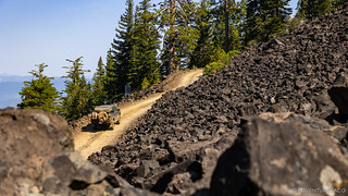
Up and up we went - through black lava fields - towards the summit.
We arrived at the summit just before 11:00am, greeted by the keeper - Fred - and his dog. Both were happy to see us, and Fred immediately invited us up to his perch.

Here we are...

...at the top of the world.
We spent an enjoyable 20 minutes or more chatting with Fred. Having grown up in the area, as a USFS employee, a forester, and a high school track coach, he pointed out landmarks and interesting artifacts in every direction. He related stories of fires, of other fire lookouts, and most importantly - of his plan to achieve a world-record time for running a marathon as a 75-year-old!
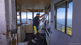
Fred was all decked out in his running gear when we showed up - he was just about to run down - and then back up - the hill around his lookout! Dude is a beast!

In the distance to the south, some of our final views of Crater Mountain, Lassen Peak, and Brokeoff Mountain through the haze.

Shadows from the clouds streamed down towards Hat Creek, where we'd be headed shortly.
Ultimately, we could have spent all day talking to Fred - and he to us - but we didn't want to keep him from his world record, and we still had a few miles to cover before we could put the BDT in our back pocket, so we bid him the best of luck on his run and began our way down the steep, narrow trails.

To the north, Mt. Shasta rose up in the distance. Its height (14,179'), and prominence over the surrounding area, make it look so much larger than Lassen Peak.

A fun view down the switchbacks of Burney Mountain.
Despite the name, there are only seven major lakes in the Thousand Lakes Wilderness - though there are many small lakes and ponds, scattered about by receding glaciers. As we wound around the wilderness - there are no roads through it - we'd see exactly zero bodies of water, though a few completely dry lake beds - courtesy of California's record drought - were present along the way.
What we did see were lava flows. Large flows, and remnants of tubes that dropped down 50-100 feet below the predominant elevation. It was hot out, but we had to take a look.

It's hard to tell in this photo, but this flow is a collapsed lava tube, and drops down significantly from the surrounding area.
Eventually - and with our stomachs reminding us that it was time for lunch - we began the final descent into Hat Creek, a lush valley, seemingly in the middle of nothing.

With the sun peeking through the clouds to illuminate the fields, the valley floor sparkled in front of us.
Section 5: From Valley to Valley - Emigration in Earnest
The valleys of this region were major thoroughfares for the deluge of emigrants in the 19th century. Using rivers as high-speed transit, these pioneers linked valleys to valleys, intensely focused on finding the quickest route to the bullion of the Sacramento Valley.
Crossing CA-89, we proceeded on pavement for the next five miles or so. I hadn't realized it - though I'd obviously created the route and waypoints at some point - but we were going to visit a radio observatory! Specifically, the first stop on the final segment of our adventure was the Hat Creek Radio Observatory.

As we pulled in, we thought all the dishes were inactive, since they appeared to be pointed at the ground.

It turns out that the signal is reflected back *up* at the dish from the apparatus in front of it, so all of these dishes were in operation.
In operation since the 1960s, the newest telescope array will ultimately include 350 dishes, each 20 feet in diameter, and will be one of the most powerful telescope arrays in the world. The large number of dishes provides unprecedented sensitivity for the detection of weak signals from space, including signals generated by extraterrestrial civilizations. The project is a joint effort between the U.C. Berkeley and the SETI Institute (Search for Extra Terrestrial Intelligence).
They move!
Not everything at the installation was operating at peak efficiency. At the end of the road, we heard a tinkling/chiming as a warm breeze blew through the valley. "Guess that one is falling apart," I joked to @mrs.turbodb.


Except that it appears to be strangely oriented, it looks ok from a distance. And after discovering that the dishes pointed down were - in fact - working as designed, I chalked up the orientation to my lack of knowledge.

In fact, this one was falling apart.
I don't think that mirror should be on the ground.
For a moment, we considered eating lunch in the shade of a large tree on the grounds of the radio observatory, but given our non-sanctioned parking, we decided to head a little further along the trail in search of less controversial shade.
We found it along the top of the Hat Creek Rim at the hang-gliding launch site.

Looking out over Burney Mountain, I suspect that I've had a favorite #1 uncle who has launched from this point.
The sandwiches were tasty as ever, and it was 2:30pm when we climbed back into the cab to a welcome blast of cold air. With well-graded roads, it looked as though we'd wrap up the trip in just another hour or so, before we'd air up and begin our sprint north - towards home.
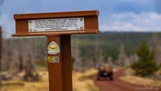
For a final time, in a meadow on top of Hat Creek Rim, we crossed the Pacific Crest Trail. Here, hikers are halfway between Mexico and Canada on their 2,650-mile journey, questioning their sanity and wondering where the closest cheeseburger can be found.

At least, I suppose, the PCT is beautiful.
In the end, our estimated hour of travel ended up taking only half of that, as we stopped only a few times for photos of this final stage. It was a great way to wrap up a trail that had surprised us both. Far from being a disappointing tour through burned forests, we'd encountered scenery, viewpoints, and people who'd made our two-day adventure one that we'd thoroughly enjoyed. Certainly more than the mule mentioned in this California Trail marker I spotted on the side of the road.
"The mule fell down this morning & afterwards I could not get him along & had to get off & strike him many times before he would start. Finding no grass here, we went on again & found a little grass but no water." -Tiffany Pardon Dexter, Oct 2, 1849
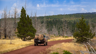
A red road through golden fields within a green forest.

Like us, wildlife was hot. This deer spent more than two minutes drinking at this small pond.

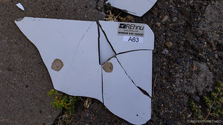
We just happened to notice this marker at the end of the Lassen NF BDT as we were prepping to air up the tires.
We reached the end of the trail at 3:28pm. Crossing the Union Pacific railway at Little Valley, we pointed the truck towards McAurther - and ultimately, I-5 - for fuel and our two-day trip home.

The trusty transporter, back on pavement.
Along the way we'd have a bit of excitement: a tire blowing as we plodded our way through Oregon, the second of the trip! As we had the first time, it was quickly replaced - thankfully we'd gotten the valve stem repaired - and we were back on our way.
And I was already looking forward to my next adventure, hopefully to somewhere a little... cooler.

Well, that's no bueno. I don't think it's supposed to look like that.

Also no bueno, we also caught a glimpse of the McKinney Fire, just as it was getting started.
As you enjoy your travels through the wild woods,
tread lightly and leave no trace,
that wind and water cannot erase.

Yo Dan...that "female frog" was actually a Western Toad. I call them Western Road Toads because I so frequently find them smashed on the road. Also, that "family of woodpeckers" tree may have been a tree where Acorn woodpeckers peck holes to store their acorns in...what was the diameter of the holes? Honk! UJ
Thanks! Updated the frog/toad. Were we correct to assume that the larger one (about twice the size) was the female and the smaller was the male?
As far as i know, the males and females are the same size. However, just metamorphosed juveniles are much smaller, about an inch or 1 1/2 inches long. I think you probably encountered a bunch of juveniles from this year and that one adult. UJ
Always love your adventures and photos! I'm curious what you think blew out your tires...looks like lots of tread left. Just the miles and miles of rocks you drive on wearing on them? Also, I would love to know what exactly "tacoritos" are, from so many of your dinner posts?
Hey Kim, glad you're enjoying the adventures and photos; always nice to hear that! The tires were caused by a couple different issues on this trip, I think. The first one - when we went to Poker Flat - was just unlucky driving. I'm pretty good about paying attention to my line, but in order to shear off the valve stem, I must have gotten too close to a rock (or a rock happened to slip into just the "right/wrong" position as we drove by). So, that one wasn't the tire's fault at all!
For the one on the highway - after we got home, I found the hole. It was in the center of the tread, and I still had a good 16mm of tread depth (new the tires are 19mm, and I replace them around 3-4mm). There wasn't anything in it anymore - it must have been flung out on the highway - but I'm sure I just got unlucky in running over a nail or screw or something that was at just the wrong angle to puncture the tire. Here are a couple pics from when I got home and had a chance to find the hole:
In the end though, a flat tire is one of the easiest repairs, so I was happy it was this and not something more serious!
Thanks! Are the tacoritos a secret recipe?
Oh, right, tacorittos! Sorry for leaving that out. I've always just called them tacos, but as more authentic Mexican street tacos have become "more common" in our culinary world - comprised of meat and various simple toppings like onions, cilantro, and lime on a relatively small corn tortilla - buddies on my trips have suggested that I'm actually making burritos...
Anyway, tacorittos are a soft-taco-sized flour tortilla, meat (generally ground beef on trips, but can be something nicer at home), Mexican rice, cheese, guacamole, and lettuce, folded in half like a taco (vs. rolled like a burrito).
Admittedly, they are a mashup of two delicious vehicles for guacamole intake, so I've just taken to merging the name, LOL.
Here's a mediocre photo of one, from day Elko-to-Austin stage of the Nevada BDR.
A good taco-rrito has as much guac as it does meat.
Aahhh, perfect! I love those. Thanks for clarifying! Just wanted to make sure I wasn't missing something wonderful, haha.
Love reading about your adventures! This is in my backyard and we have done some of these spots. Burney Lookout was awesome! We managed to get 20 or so vehicles up there one day on one of our runs!
Thanks Michele, glad you're enjoying the adventures - hopefully you've signed up to get emails when I post new ones! If you're near Burney Lookout, you've got a great backyard. I mean, you could use a little more rain and snow, but so many great places to explore around and check out. I spent a lot of my summers growing up in the Quincy/Taylorsville areas, so it was a lot of fun to get back there for this trip. Have fun out in the woods! ?
My wife and I both enjoyed your trip reports. We are headed out Friday from Eureka CA for 10 days. Our hybrid BCDR will start on the 6R BCDR to the Lassen, Modoc and return on the Shasta-Trinity. Hopefully we have time to explore everything, being right there, but running out of time is the worst!
Have a great time out there Trey! What's the 6R BCDR? (typo, or one I've not heard of?)
I know it's not all there in CA, but I loved the Siskiyou Crest Adventure Trail which is just over the border, and in a similar vein! 👍
Six Rivers Backcountry Discovery Trail, there is a link on the Overland trail guides website.
https://www.overlandtrailguides.com/post/six-rivers-backcountry-discovery-trail#:~:text=Six%20Rivers%20Backcountry%20Discovery%20Trail%201%20Route%20Overview,5%20Resources%20Land%20Managers%20...%206%20Gallery%20
We survived our trip! it was just over 1000 miles in our 1988 Jeep Comanche. I would say that the first half of the Lassen route was definitely my favorite. I got kind of tired of seeing trees on the last half of the Lassen route and much of the Shasta-Trinity route. 😂Unfortunately the highlight of our trip was supposed to be exploring the volcanic features in Modoc county, but a storm moved in just as we arrived at Medicine Lake with very high winds, rain, snow and freezing temperatures. No fun in a tent, so we got out of there. The Velcro and zippers were all frozen, so I had to use bungee cords and ratchet straps to secure it.
Your tip about the lack of fuel in Mineral was helpful, it was only 12 Miles to Chester when we made it to the highway, it would have been much farther had we tried Mineral first. Thanks for your awesome trip reports, keep it up!
Awesome, glad you made it, and had a good time. Weather is always hit and miss this time of year, but I bet it was beautiful with a bit of snow and some ultra-saturated colors after the rain!
Those tree tunnels can get a bit old - part of the reason we don't do a lot in our home territory here in western WA, but when there are breaks in the trees, the views are unbeatable.