

It was just after 5:00pm as we rolled out of Elko after fueling up. This, technically, had been the end of our first stage - but with several hours of daylight left and dirt roads calling our name, we felt no need to call end our adventure early!

On that note - something @mrs.turbodb and I find interesting about the Backcountry Discovery Route (BDR) stages is that they all start and end in towns. This - to me - doesn't make any sense. I mean sure, it's easier to map from one town to the next, but it also means that the end of a stage is by definition not somewhere you're likely to want to stop and camp for the night. In fact, you probably don't want to stop anywhere near the end of a stage, since being close to a place with food and gas is likely to mean traffic, lights, and crowded camping. The only thing I can think of is that when travelling by motorcycle - which is how the BDRs are developed - packing light, eating at a local joint in town, and staying in a motel is an easier way to travel (though still, most of the BDR reports I've seen from bikers employ camping each night).
I digress... where was I? Oh right, headed out of Elko.
Continuing south, we quickly racked up miles between ourselves and civilization. This was a good thing - for the reasons I mentioned above - and we enjoyed the views of the Ruby Mountains to our east as the snow-capped peaks towered several thousand feet above our route.
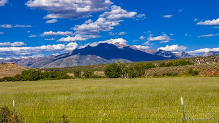
Travelling mostly through what is now ranch land, @mrs.turbodb let me know that she was pretty sure we were on the Hastings Cutoff of the old Emigrant Trail (aka California Trail) - a route taken by explorers before us on their way to settle the west! So, as we noticed an an old rock ruin in the distance, curiosity got the better of us and we turned off the route for a closer look.


We obviously have no idea the age of this place, but it's clearly been around quite some time - the cows now it's primary residents. Inside, full-dimensional milled lumber boxes for the windows suggested that it was most likely the residence of a reasonably modern-day homesteader.

A purported shortcut to the Emigrant Trail, the Hastings Cutoff turned out to be no easier for the wagons than the original route. Most famously taken by the doomed Donner-Reed party. Hastings promoted the trail without having actually traveled all of it, claiming that it reduced the trail to California by hundreds of miles. The Donner-Reed party, with help from Hastings, took this route, costing them an extra month on the trail, which ultimately delayed their start into the Sierras, and for about half the party, cost them their lives, dying in the mountains, only to be eaten by the rest of the party.
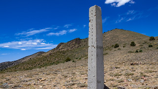
Just as @mrs.turbodb was reading about the history of this trail, I spotted what I thought might be a marker along the side of the road and applied the brakes. We got out to take a look.
"We started on toward or Canann, with sorrowing hearts, for now the awful and fearful truth flashes across our minds, that our provisions are nearly gone." -John Wood, Aug 18, 1850
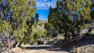
40 miles out of Elko, we turned west, up into the Cedar Ridge Wilderness Study Area.

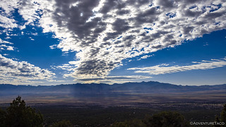
Anyone who's camped with me knows that I'm always a fan of finding a ridge along which to camp, and my hope was this part of the route - which crossed a ridgeline - would be a great place for us to stop for the night. Clearly - and perhaps obviously - previous adventurers shared my preference and as we reached the ridgeline, a lightly-travelled trail dove off the main road to the south - into BLM land!
We followed it to our overlook.

Where we setup camp.


And made dinner.

A bit of sunlight still left in the day once we finished cleaning up, @mrs.turbodb and I decided to hike out the ridge a bit further, just to see what we could find. Not much, it turned out, though we did stumble upon a little egg shell, its inhabitant now in the wind, literally.

And, as the sun set to our west, we made our way back to camp and into the tent. It was warm but pleasant - a very nice change compared to some of our trips where we're cold as we climb under the covers.


Day 2
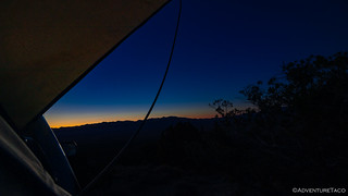
Being the middle of summer, sunrise was early! I nearly missed it when my alarm woke me at 4:45am, and a quick photo from the warmth of the tent was all I could muster before falling back asleep for another couple hours until the warmth of the sun - even through the clouds - was enough to send us both scurrying for the cooler air outside the tent.
A quick breakfast and teardown of camp before we were on our way, through the juniper trees that cover Cedar Ridge  , on our way to Austin.
Having seen only one road leading away from the Cedar Ridge Wilderness Study Area to the west, we figured that it would be our way out - and it was, Squaw Mountain rising up 6759 feet in front of us and Cissilini Canyon to our north.


Not technically on our route, a road down into Cissilini Canyon looked too interesting to pass up, so we called an audible less than 20 minutes into our day and headed north. The canyon did not disappoint, not by a long shot!


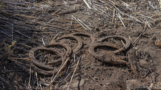
it was only a quarter mile or so beyond this that we came to the ruins of what was clearly an old town, perched along the side of Dixie Creek - some old horse shoes still scattered on the ground near one of the buildings. What a fortunate discovery for us!


A bit of poking around and it was time to go - the NVBDR stage from Elko to Austin is one of the longer ones at 220 miles; we didn't want to dally - so we headed back up the canyon with a different view of Squaw Mountain.

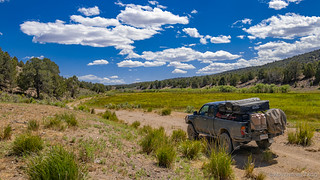
Our route now took us squarely through high desert. The land around us was dry - the only water, the result of springs that we'd stumble across here and there. And then, the desert would come to life - though only for a few feet on either side.


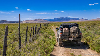
Mostly though, long dirt roads carried us through grazing land - most of it leased by the BLM to various ranchers, the limited water and grass only enough to support a small number of cattle.

As we neared the north end of the Diamond Hills, a few of the gates that @mrs.turbodb had to open (and close) were in close proximity to a spring that'd been overrun by cattle, but that was also home to a group of four migrating female American Avocet in breeding plumage - at least for the time being.


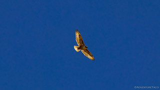
And, a little further up the road, a juvenile Red-tailed Hawk put on an amazing display for us as it caught a thermal high into the sky above us.
And with that, we'd reached our route up and through the Diamond Hills - again, an "advanced alternate" route for this stage of the BDR. Additionally, as it turns out, this part of the trail - as would much of what we'd travel the remainder of the way into Austin - was part of the old Pony Express route.


Though we all know of the Pony Express, I had no idea that it only operated for 18 months. Running from St. Joseph, Missouri to San Francisco, California, riders (called Pony's) carried mail across the entire route in ten days, where the previous service had taken 2-3 months.
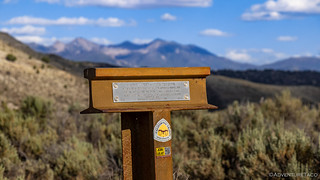
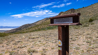
It was lunch time when we reached Overland Pass - the saddle that would lead us down into Telegraph Canyon and despite some howling winds and no shade, we made the call to eat lunch here - surely it would be more pleasant than the stagnant sweltering heat in the valley below.

There were several markers here as well - for the Pony Express, for the California Trail, and for an old Ham operator (Bob Evans - N6YMA) who must have loved this place.

Our bellies full of chips, apple, and PB&J, we plunged down into Telegraph Canyon - 10-foot tall sagebrush making it a tight squeeze even for a 1st gen Tacoma. The trail here too was rougher, likely what afforded it the "advanced" moniker from the BDR.

We popped out on the valley floor just in time to see a reasonably large whirlwind make its way across the playa in front of us.

The road conditions here in the valley got better once again, and we made great time on the dusty roads, the wind not quite as calm as we'd thought it would be.

Our circuitous route took us through several passes and valleys at this point as we worked our way generally south west.


And then, in the literal middle of nowhere, we stumbled upon a huge pipeline and pumping station. Still under construction, workers toiled away in 95°F heat to build the stations as we flew by in the Tacoma, our A/C keeping us cool as the air outside got warmer.

We didn't know it at the time, but the circuitous route we'd been following wasn't completely random. A marker, as we climbed into the Toiyabe National Forest near Mt. Prometheus, alerted us to the fact that we'd been following the Pony Express Trail the entire time, even after we'd left Telegraph Canyon just after eating lunch.


The final pass behind us, we started our final descent down into Austin. Having seen plenty of cows so far on the trip, a hillside covered in these fluffy little sheep caught us a bit by surprise; the sheep too, which were much more skittish than most of the cows we'd encountered!

And with that, we dropped into Austin.

We entered town right at the location of the Gridley Store. A nondescript rock building, it belonged to Reuel Gridley. In 1864, Gridley lost an election bet and agreed to carry a fifty-pound sack of flour the length of the town, which was about a mile. After his trek, the sack was auctioned, with proceeds going to the Sanitary Fund, predecessor of the Red Cross.
During the auction, the flour was resold many times, each buyer returning it to be bid on again. By the end of the day, the sack had raised more than $6,000 for the fund. Other communities heard of the fundraising and invited Gridley to conduct similar auctions throughout the West. Over the course of the next year, he raised about $275,000 for the fund! Today, the famous sack of flour is on display at the Nevada Historical Society in Reno.
Unfortunately, though Gridley raised the equivalent of $4.5 million for charity, he lost his store to personal bankruptcy, since he was always travelling. (Roadside History of Nevada)

As we made our way through the small downtown to fuel up, it was just a little after 5:00pm. We'd covered even more ground than the previous day, but we obviously needed to push on in order to find a spot to camp.
This, I knew would not be a problem - I'd read a few trip reports of the NVBDR prior to setting off on this adventure, and I knew that just south of town was an amazing ridge. It wasn't on the official route, and it would surely be slower going than the valley-based track that the BDR riders had put together, but I was pretty sure that our 30 mile detour would be a highlight of the trip.
...it turns out, I had no idea.
The Whole Story


Interested in traversing entire states? Check out
More BDR's
for all the amazing routes we've run over the years.
Nice telegraph pass is a fun trip up and over! I took my fullsize chevy through there fully loaded. Quite the adventure and the pen striping was real!
Oh man Keith! I can only imagine how tight it is through there with a full-sized rig. We were joking about how we should bring some of our friends who have a 5th gen 4Runner through that route to get them to not care so much about keeping it pristine! ? Hope you're enjoying the stories!
Regarding the Pony Express and HAM radio, check out this PBS "Wild Nevada" segment on the annual reenactment of riding the pony express route. HAM radio operators, one who is interviewed about midway through the episode, provide an important service to those riders and their horses.
https://www.pbs.org/video/episode-811-arriving-by-pony-express-gnwcwn/