
On a ridge at 8,133 feet above sea level, Mahogany Flats campground is reasonably well-known for cold, windy conditions. Luckily for us, the wind wasn't too bad, but temps did drop down into the 30s for much of the night - a nice change, actually, given that we we'd brought along two down comforters and had been rather warm on the first couple nights of this trip.
We'd camped here - unusual for us, given that it is a campground and we generally prefer a more secluded setting - the night before in order to set ourselves up well for what I hoped would be the highlight of our trip: a hike to the top of Telescope Peak - the highest peak in the park - at 11,049 feet above sea level and an additional 282 feet above the base of the Panamints in Badwater Basin.
With 15 miles of hiking ahead of us - we planned to add a couple extra miles by summitting Rogers Peak (9,980') at the same time - we were both up with the sun; making breakfast and lunch, applying sunscreen, and making sure that we had the various batteries, cameras, water, etc. for our jaunt.

Nearly ready to go as the sun's rays were starting to spill over the Black Mountains to our west.

A full moon was just setting to the east.
One of the highest summits in the California desert, the 6.4 mile trail from Mahogany Flats has a total elevation change of 3,480 feet - each way - with two ~1700' climbs separated by a reasonably level hike along the ridge between Rogers Peak and the final climb up Telescope.

Knowing this hike could take us the better part of the day, we left the Tacoma setup in camp for easy occupation on our return.
The trail starts just south of the camp ground, and after signing in at the register - with the wrong date  - we started up the trail in high spirits. I, for one - and I would later find, @mrs.turbodb as well - was wondering if we were crazy. After all, we'd hiked the lowest peak in the park just two weeks earlier and with only a 1,900-foot elevation change and 4-mile roundtrip, it had sort of kicked our butts.

Looking excited and ready to go!
Immediately, the trail begins to climb up through the Juniper and Pinion Pine forest. Here and there the trees thin, and the first - of what turned out to be nearly endless - views opened up to our east. Both still full of energy, we'd soon removed our sweatshirts, the warm sun and cool morning air creating the perfect conditions to start the day.
Basin and Range extending over 100 miles into Nevada.

Into the light.
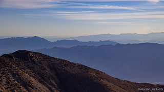
After a little more than two miles, we reached the end of the first major climb and found ourselves in an alpine meadow along the ridge between Rogers and Telescope Peaks. We'd skirted along the west side of Rogers peak for the first part of the journey, a bypass that we'd forgo on the return leg of the hike. This area - now mostly out of the trees - gave us our first views to the west, Panamint Valley stretching out below us, the Nadeau Trail - which we'd travelled exactly one year earlier - just visible in the distance.

Our first look at the Telescope Peak summit as we gained the ridge for the first time. Not too much now up there, luckily!

Far in the distance to the south, reflecting off the desert floor between the ridges of the Owlshead Mountains we could make out Lost Lake, which we'd hiked a couple weeks earlier.

Panamint Valley and the Argus Range. And in the distance, the Sierra.

Cutting through the haze, the white splash at the base of the Argus Range is the Panamint Valley Limestone Quary at the mouth of Revenue Canyon.
We continued on, the trail along the ridge, skirting to the west of Bennett Peak, and saving us from an additional several hundred feet of elevation gain. At this point, we were hovering right around 9.500 feet above sea level and making good time - it was still before 9:00am.

A @mrs.turbodb sunstar.

Looking back as we navigated the ridge, we could now see the summit of Rogers Peak - still above us - the only high peak in the park that is not in a wilderness area.

Below the peak, the trail we'd climbed.
Just as we started to climb again, an ammo box geocache and flat camp spot caught our attention. Curious as to why there'd be a cache here - rather than at the top - we made a quick detour to check it out. Turns out, it was primarily a first aid kit, and we realized that the flat spot was a primo camp spot, with fantastic views of the valley.

Sheltered from the westerly winds, this would be a great place to setup a tent for the evening.

As our elevation increased, the effects of the weather on the landscape became apparent. Ancient bristlecone pines, twisted and tortured by the wind, no longer adding rings to their trunks.

Still, others continue to survive.
An hour or so later - as we reached 10,000 feet above sea level and the base of the switchbacks that marked the steepest section of trail, we decided that this would be the perfect spot to eat lunch. Doing so would ensure that we were fresh for the final push, and would reduce weight from our packs - not that they weighed all that much to begin with.
Plus, who doesn't want to eat potato chips with an infinite view?

Tuna at 10,000.
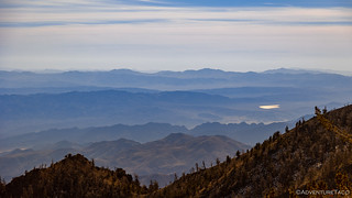
In the distance, Lost Lake continued to gleam.
Twenty minutes later, we were back underway. The Telescope Peak trail is one of the few maintained foot trails in the park, and the last couple of miles is where we noticed the care that's been put in to keep it in great shape. Here, a series of 6 - or 12 depending on how you count - switchbacks climb to the peak. Each one is built up with natural rock walls - expertly pieced together - that surely help to keep the trail in better shape through harsh weather as well as reduce the amount of corner cutting that hikers might otherwise attempt.

Some of the rocks in these walls must have weighed two hundred pounds.

Weathered giant.

Finally above Rogers Peak, the Grapevine Mountains rising in the distance.
It took us approximately 45 minutes to traverse the switchbacks, ultimately reaching the final ridge that led to the summit. We weren't sure at this point whether there was more beyond what we could see - the hike so far hadn't seemed all that difficult - but I'm sure we were both hoping that we'd made it!

The final few hundred feet.
And with that, we reached the summit! The views - as one can imagine - were beautiful. Stretching for a hundred miles in every direction we could see well into Nevada to the east and across Panamint and Owens Valley to the Sierra to the west. For a while, we just soaked it all in.

What a tourist. Geeze.

I thought this survey marker was interesting because it contains no identifying mark.
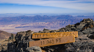
In case you weren't sure where you were, someone had left a reminder.

The view to the east, across Death Valley.

Looking west, over the Argus Range, you can make out a sliver of Owens Lake, with the Sierra - and Horseshoe Meadows Road - rising up behind it.
We spent half an hour at the top of the world - or, at least, at the highest peak in the park - before starting back down just before noon. It'd taken us just under five hours to make it this far, and while we figured that the hike down would be faster than the trek up, we did have that little detail of a second peak that we wanted to work into the mix.
Headed back down, glad to have our sweatshirts at these high elevations.

The views going down were perhaps even better than those going up, since we didn't have to turn around to see them!

The smells. Oh, the smells.

A reminder that the weather up here can be brutal, and that lightning can make for a terrible day.

As the sun worked its way across the sky, the view of Panamint Dunes - at the extreme north end of the valley - seemed to get better.
Ninety minutes later, we were nearing the base of Rogers Peak. A short spur off of the Telescope Peak trail indicated the way up, but quickly petered out after about 100 feet. I'm not sure if this was due to everyone choosing their own route to the top, or because not many folks are itching to "go back up" after having just hiked Telescope, but we figured that the 300-foot climb from here was way better than a 1900-foot elevation gain at some future date!

Skirting around Bennett Peak, with the radio towers marking our next destination.

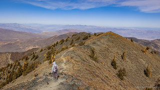
Second peak of the day.

Layers of views into the distance, through the Rogers Peak NOAA weather station.

A new, 28-foot-diameter radome built by the US Navy in 2020 contains a radar telemetry antenna. The paneling of the radome was quite intriguing and certainly adds a new look to the summit.
We didn't spend more than a couple minutes at the summit of Rogers Peak - there's really not all that much to look at - before starting back down towards Mahogany Flats. It was right around 1:30pm at this point, and we decided to take the service road - despite it being a bit longer - down the mountain, just to we'd have a different view than our hike up.

The colorful Funeral Mountains have surely distracted you from finding the Tacoma and deployed roof top tent in this photo.

With a bit of zoom and a little recentering.
We arrived in camp an hour later. While we were both ready to get off our feet, we also agreed that the highest peak in the park had most certainly been an easier hike than the lowest peak in the park a couple weeks earlier. Whether this was due to the nine-mile hike to Crystal Hills we'd done prior to summiting Owl Peak, or with the well-trodden trail (vs. a cross-country trek), we may never know. But, given that it was only 2:30pm in the afternoon, we figured that we might as well start heading north in order to split the 20-hour drive home across a couple of days, rather than spending another night at Mahogany Flats and setting out the next day.
So, forty-five minutes later - our tent packed up, our tires aired up, and our feet happy to transfer the weight of our bodies to our butts - we pulled out of camp and covered the few miles down to the Charcoal Kilns. One of the wonders of Death Valley's early mining history, these unique ovens were used in the 1870s to manufacture charcoal for the Modoc Mine - on the far side of Panamint Valley - that we'd visited as part of our Nadeau Trail adventure.

Amazingly well preserved after 150 years!

And with that, we rode off into the sunset. Well, the late afternoon sun, anyway.
It'd been another fun trip - one where we'd accomplished everything we'd set out to achieve, and more. And now, just two weeks after proving that we could underachieve with the best of them - tackling the lowest peak in the park, we'd proven that - when push comes to shove - we can tackle the highest peak in the park as well.
Even if it is... easier. 
The Whole Story


Love Death Valley? Check out
Death Valley Index
for all the amazing places I've been in and around this special place over the years.
As always Thanks for a great read and fab photos.
Excellent photos, I think these are your best!
Keep on trekking Dan and thanks for sharing your trips we love them all.
Thanks Kenny, glad you enjoyed them as always! Hope you and your family are having a Merry Christmas.
Excellent photos. Really like the old Bristle Cone.
Thanks Tony! Those were pretty cool, and made me want to visit the Ancient Bristle Pine Forest more than I have in the past! Perhaps a trip for next spring... Merry merry!
That marker with the arrow atop Telescope Peak is not a Benchmark, but rather a witness mark. Often a BM will be placed and then four witness marks placed around it, all pointing to the BM, both to make it easier to locate, and if it is damaged to help reestablish its location.
You often talking of airing down or up. I fully realize the usefulness of this when faced with deep sand, but elsewhere it seems actually harmful, as it causes the sidewalls to bulge out, and they are the most vulnerable part of the tire. I'm sure you have a good reason for this, but I would like to know it.
Hey Anthony, thanks for the primer on the markers! I feel like I see so many different kinds out on our adventures that I never know what to call them, so - as in this story - I’ve just taken to calling them survey markers ?! Interestingly, looking at the photo above, this one has “benchmark” inscribed on it. Does that mean anything? How do I differentiate or identify the different marker types?
As for airing down - as you note, there is a trade-off there in that the sidewalls can be more exposed. The benefits, though, are in the ride and traction provided by the softer tires.
From a ride perspective, the lower pressure tires are able to absorb many more of the bumps than tires at full pressure. So, when going over rocks or washboard - something that is very common in Death Valley - absorbing those bumps is extremely beneficial to both the Tacoma (welds, metal fatigue, etc.) as well as its occupants.
From a traction perspective, the larger contact patch gives you much more control when going around curves, braking, etc. When fully aired up (40psi for my Load Range E tires), going around a turn on a gravel road at speed can result in slipping off the side of the road whereas with the tires aired down (18psi), the truck simply absorbs the small bumps and makes the turn.
Let me know about the various markers, I’m super curious, and hope you’re enjoying the stories!
There was good info on a website now abandoned, but available on the Wayback machine:https://web.archive.org/web/20050207151117/http://www.dustyjacket.com/benchmarks.html
also see
https://web.archive.org/web/20041227055058/http://www.dustyjacket.com/benchmark/benchmarks_witness.html
A good background on the history of benchmarks:
https://www.geographyrealm.com/benchmarks/