
With daytime temperatures in the high-80s °F, we figured that getting an early start on our six-mile hike to Cave Draw would allow us the most pleasant experience, so I'd set my alarm for 5:30am - enough time to get ready to go just as the sun was peeking over the horizon half an hour later.

Cave Draw, a three-mile long drainage that leads to the Bruneau River, was a place that piqued my interest as I researched the area. Generally accessed by floating the waterway - something that's only possible during the month of May on high water years - one particular photo I found was enticing enough to plan this entire trip around.

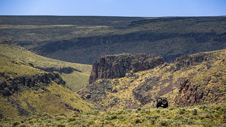
The drainage started out as a mere depression of the land, the green grass flowing down the hillsides, our path meandering for a mile or more in a broad wash. Eventually, we reached the first steps of volcanic boulders, the drainage becoming more overgrown and our progress slowing for the second mile of the three-mile "out" segment of our journey.


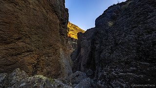
With less than a mile to go, it seemed as though we'd found an alternate - if slightly longer - route to this special place. At the very least, our pace began to quicken as we hadn't run into any insurmountable obstacles. Then - right on cue - I knew we were finished. A couple hundred feet ahead of us, the bottom of the wash dropped out from under our feet - a series of chimney-like 75-foot dry falls plummeting down to the best that Cave Draw had to offer.


It was only 7:15am, and we'd been foiled. I suppose we should have expected to find what we did - I've never found any mention of hiking to Cave Draw - but I must admit that we were a little bummed as we picked our way back up the drainage to the Tacoma, our sights now set on the remainder of the day, our hopes high that the remaining foray's into the canyons of the Owyhee would be more successful than the first.


Reaching Rowland Road - the main north-south artery of the region - we turned south towards a series of homesteads and overlooks that would take us all the way to the Nevada border.
The first order of business was finding a place to eat lunch, preferably with a bit of shade. Having skipped breakfast - and though it was only 11:00am - our four-mile hike left us both hungry, but not hungry enough to brave the sun that was beating down, already warming the air to the mid-80s °F.
It may come as no surprise to those who know the area, but ultimately our search for a tree was unsuccessful.


After twenty minutes - and a grand total of zero trees to shade us from the sun, we found ourselves crossing the old wooden bridge to the John Cowan Place. Nestled along Cat Creek, only a bit of shade would have made it a more perfect setting to poke around for a few minutes while turkey sandwiches and Cheetos magically materialized on the tailgate of the Tacoma.


Our bellies full, and the sun directly overhead, we retreated to the cover of the air-conditioned cab as quickly as we could after refilling our water bottles and putting away what little we'd used to make lunch. This lasted just long enough for @mrs.turbodb to cool down and nod off, before we found ourselves at one of the more dramatic overlooks of the day at a spot just above Fred Robertson's Place.


Having interrupted my companion's prime nap time, it seemed only fitting to allow her a few extra moments before the next stop. As such, I sped past a few places I'd marked and followed the undulating, well-graded road all the way to the Nevada border.


For a long time, we thought of Owyhee as a region of Southeast Oregon - specifically the area in and around the small town of Jordan Valley - with the Owyhee River serving as a centerpiece to Jordan Craters, Leslie Gulch, and of course, the Succor Creek Natural Area. It is - we now know - a much larger place, spanning a large swath of southwest Idaho, and a good chunk of northern Nevada. And, while we've visited the Idaho slice a couple of times, the Nevada potion remains completely unexplored - only a fleeting visit as part of the Nevada Backcountry Discovery Route (NVBDR) as we passed through Jarbidge.
But now was not the time to change all that - this was a trip to Idaho-wyhee - so after making a u-turn in the middle of the road, we retraced our path under sunny skies and puffy clouds to a few of the places we'd passed in our journey south.


By now it was nearing 4:00pm and while we had a plan - a place I hoped to be the highlight of our trip - in mind for the evening - it seemed only prudent to visit a nearby overlook of Sheep Creek before we headed back towards the Bruneau River for the remainder of our time.
Soon, we were overlooking one of the deep, winding, gorges that this place is famous for and even in the hot afternoon air, we both spent a good 10 minutes admiring the view.


With that, I knew it was time for something very special. As we once again retraced our path towards Rowland Road, I did my best to prep my co-pilot for what was ahead.
"I think this is going to be similar to the steep road down into Indian Hot Springs," I warned her. "And once we're there, I don't know if there will be a road along the river, or if we're going to have to hike a couple miles."
Knowing that the road to Indian Hot Springs wasn't anywhere near her top-10 list of favorite roads, I was relieved when the only reaction I got was a sideways glance. In the end, I probably deserved a lot more flack for what we were about to do as we went... Over the Edge.


Spectacular views/shots! That cabin insulation image is fascinating.
Thanks Sherry! Glad you're enjoying them! ?
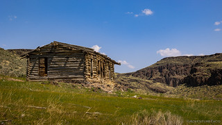
The TM Ranch, Louis Eastman, and Tokenbamby Ranch are owned by Simplot Cattle Company. The ranch hands at each place generally last about 3 to 4 years on average due to the remoteness of family life.
The canyon overlooks are spectacular and make one question why these pioneers came to this place. But then during the Homestead act times, the Government only gave out land that was undesirable to get a population started there. These men and women and children were the original pioneers that knew nothing but hard work.
Before the pioneers came to this area in the 1800's the fur trappers blazed the trails in the 1700's trapping beavers. Only a small group survived these times and food was sparse and some ended up eating the beavers and their wore out horses in the brutal winters. Now there are few beavers left so be sure to take all you will need as the stores are nowhere to be found.
At one time there were a lot more trees in the area and the sagebrush was 8 to 10 feet tall, once most of this was depleted a lot of the homesteaders sold out or just left for a better life. A lot of the trees were freighted in from Mountain Home on the stage route to Jordan Valley.
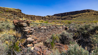
There are small homesteads spotted throughout the area that are difficult to reach without an off trail rig like yours or an ATV. Only occasionally will you ever come across another human being due to the remoteness.
For future travelers to this little slice of heaven be mindful of your adventure and respect the ranches and the land for future generations to enjoy. Only leave with memories and pack out your trash.
As Roy Rogers sang at the end of each episode, Happy Trails!
Happy Trails!
My Uncles actually owned this ranch for decades before they retired and sold it to Simplot in the 80s.
Hey Tony! We visited several ranches on this visit, which one belonged to your Uncles? I always love it when folks who are personally connected to the places I've visited have a chance to read my trip report and reach out. If you have any stories from your or their time there, I'd love to hear them. They add so much context and additional color to a place that I've wondered about as I've visited (with no info besides what I can see) myself.
Tokenbambi was the one I was referring to, but back in the day my Uncles ranched from just south of Grasmere all the way down to into northern Nevada before they sold it all off to Simplot. There were several ranches they bounced between in the area. I was just a wee lad back then so don't remember a lot of the names of the various ranches, but I do remember tokenbambi very well, and another place that I remember vividly was called the Jones place and that was on that same road, but down by the Nevada border. I think it is either ruins now, or was completely torn down.
Thanks Tony. Last spring we ventured into the Northern Nevada part of the Owyhee for the first time - having spent our original trips in Oregon and Idaho - since I felt like I really wanted to get a sense for the entirety of the Owyhee. As part of that, we went by the Jones ranch - now gated and signed as No Trespassing - as I recall, on our way to the east bank of Black Rock Crossing. As always seems to be the case in Owyhee, we had a great time, very much enjoying the peace and solitude that always seems present. If you're curious, here's the trip report: Owyhee Downlands (May 2025).
I'm sure that's a mixed bag for you and your family given the ranches being sold to Simplot (or at least, I think it probably would be for me), but hopefully it's still a place that you can remember for the good times.
Very nice travelogue as always. Places that we can't visit but enjoy seeing through your eyes and adventures. Thanks again for sharing!
as allways, nice to read your tripreports. keep'em coming
Thanks Jan! Glad you enjoyed it. More homesteads in the final part of the story as well. ?
How do you get to the cave draw area where you got foiled only to turn around?
Hey Lucas, here's my approach on describing and sharing routes - https://adventuretaco.com/guide/do-you-have-a-gpx-for-that/ - the information is mostly available in my stories, but usually requires a bit of work with the stories and a map.
A lot of times, it's easier to get more context by starting at the "beginning" of the trip and following along that way, rather than trying to jump in at the middle (like, just starting with this particular story). Trips are always linked at the top of each story (just under the title), and in this case, it's Idaho-whyee (May 2023)