
With the warmer weather finally making its way north, and the Tacoma at home for a bit of maintenance after the last several months of living in Las Vegas, @mrs.turbodb and I thought that it would be fitting to mark the anniversary of our very first trip in the Tacoma by visiting the Owyhee.
We wouldn't explore exactly the same spots - we rarely do - but we'd find ourselves in wonderfully similar surroundings, the fleeting green grass of spring welcoming us back. This time we decided to explore the Idaho side of this amazing wilderness, setting off on a warm Wednesday morning for the 12-hour drive south.
I must say - in the six months we've stored the truck in Las Vegas, we've been spoiled. Not long ago, a 12-hour drive would have seemed like child's play to us, a mere footnote on and adventure. But with two-hour flights now the norm, we were both ready for bed when we arrived in pitch darkness and a bit of rain - our first camp site along Sheep Creek, a location we hoped would afford a dramatic view the following morning.


Luckily the rain didn't last long and by the time we woke up in the morning, the tent was dry. More importantly - as the mud in this area can be notorious - the roads were dry as well, or at least as dry as they could be with all the extra moisture that'd fallen out of the sky as white stuff over the course of the winter.

Having slept for a couple more hours after my initial pre-sunrise photos, it was nearly 11:00am when we finally rolled out of camp. As much as I am usually an early-morning riser, I have to admit to welcoming our slower pace on this particular morning as I recovered from a head cold that probably should have kept me home anyway.


It was as we were cruising along - at reasonably slow speeds - that I heard the first light screeching noise coming from the front passenger corner of the Tacoma. Pretty sure that the culprit was simply a rock stuck in the brake dust shield, I didn't think much of it. Over the next few minutes, the sound became louder. Eventually, when @mrs.turbodb commented on it, I stopped the truck and backed up a few dozen feet - usually enough to dislodge any debris that's found its way into this annoying location.
Unfortunately - despite several more attempts at dislodging the rock - the noise remained. Not only that, but it got worse. Within a few miles it was worryingly loud, and I began to question my initial diagnosis - could it be that my wheel bearing was going out? That would certainly be a problem.
Resigned, we decided to get to the highway - the direction we were headed already - before digging into the situation any further. That way, if it turned out to require a tow, at least we'd be on pavement and save ourselves a few bucks.

While I jacked up the front of the Tacoma with the Hi-Lift - an easy job given the jack points cleverly built into every @RelentlessFab bumper - my copilot took the opportunity to make turkey sandwiches for lunch on the tailgate. These would have been welcomed under any circumstance, but in this particular case they afforded me a celebratory meal when a small rock fell from the brake dust shield a few moments after I removed the front wheel! My original diagnoses had been correct, and I wasn't going crazy! 
Our spirits lifted and bellies full, we crossed the highway towards a series of locations that seemed interesting. It's here that I should note that we owe much of what we experienced on this trip to Kenny - a fellow explorer of the Owyhee region who has spent decades combing the roads and compiling the history of this amazing place. In fact, Kenny and I had tentatively - finally - hoped to meet up on this very trip, until his excursion was delayed a week, resulting in our departure on the day before he arrived! 
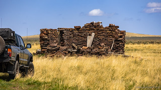

We're always up for a good homestead ruin - and we'd get plenty of those on this adventure - but what caught our eye as we pulled up to the Sego Place was a compound in the distance. Really, there wouldn't have been anything noteworthy about it, but for the fact that we'd seen another unexplained - at the time - compound less than ten miles away on a previous trip to the area with Mike @Digiratus, Zane @Speedytech7 and Ben @m3bassman, a few years earlier.


Sure enough, the information we'd been provided as a result of the previous foray proved correct, signage on the fence alerting us to the fact that this was a government facility, and that we'd better not get too close, as the entire place was a laser range used for target practice by the planes that were constantly buzzing us overhead.


From one military installation, we set off towards another - more somber - attraction. Somewhere west of Grasmere - out in the middle of the desert - a plane crashed decades earlier. Strewn over a half-mile, several components of the aircraft remain on site, a testament to those who lost their lives in the service of our country.


On October 2, 1969, RF-4C #65-0889 took off from Mountain Home AFB, Idaho, for a night-time, low-level navigation training mission. The aircraft was with the 67th Tactical Reconnaissance Wing, 10th Tactical Reconnaissance Squadron. In the pilot's seat was Major Walter Biolley, and in the rear seat was navigator First Lieutenant James Coleman.
Their instructions were to fly east to Idaho Falls and back, following several checkpoints along the way. If weather and fuel allowed, they were instructed to make one practice photo run at the Saylor Creek bombing range before returning.
At 9:30 p.m. the flight radioed the wing command post and was cleared for a pass over the range. Shortly after this 65-0889 encountered bad weather, and at 9:51 p.m. the RF-4C collided with terrain about 35 miles south of the base. The aircraft was completely destroyed and both men were killed instantly. geocache at site


We wandered for a while, trying to gain access to the fuselage, but the snowbank and thicket of trees were enough to keep us from reaching the final piece of wreckage. And, while we noted a road that accessed the area from the opposite direction, we ultimately opted to continue along our planned route, rather than taking a 26-mile detour to end up in approximately the same location.
Instead, our route would take us south - along the edge of the plateau and the never-ending snowbank - as we set our sights on something relatively rare in this neck of the wilderness - rock art!

Knowing that we'd be flirting with snow if we got much above 5,600-feet, I'd done my best to keep us at elevations of 5,100-feet and lower throughout the trip, but I'd missed the fact that this part of Owyhee climbed to just over 6,000-feet.
Except for potentially blocking our path, the snow itself wasn't really a problem. Rather, it was the melt - and resulting high-desert Owyhee mud - that had us keeping a sharp eye out as we continued along the road. We've been stuck in the Owyhee muck before, and experienced the mess that it can create more than once; neither of these were situations we wanted to repeat.

A quick look on the topo map suggested that one northerly-facing rock art site would likely still be hidden by snow drifts, while the other - facing south - stood a good chance of being exposed. Of course, the roads themselves were anyone's guess.


It was 3:00pm - and only a few tense sections of trail - when we reached the first site. Sure enough, a snowbank covered many of the rock faces, but we were elated to discover that the petroglyphs themselves were already exposed.


Excited that the first set of petroglyphs had been accessible, our spirits were high for the second set. In hindsight, this may have been a bit of chicken counting-before-hatching, but you know what they say about hindsight and all that.

Skirting the snow again, we eventually found ourselves parked along the escarpment between the two levels of the plateau. It was time to start our search.

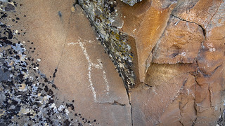


Needless to say, we were thrilled with the petroglyphs we'd seen at this second site. While there'd been more snow here than we expected, so were the number of glyphs along the boulders of the escarpment. And then - as I made my way around the corner of a protruding rock, I spotted something totally unexpected - a pictograph panel!
I've never seen pictographs in Owyhee - though we have discovered a few a little further west - so I was super excited to see the red pigment still easily visible on the wall. Amazing how something like that can survive for so many years.
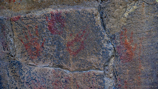

Strangely, the pictograph panel ended up being just another panel in a long series of petroglyphs, and after calling @mrs.turbodb over to check out the amazing discovery, I continued down the line.


Flush with success from finding two rock art sites, we threaded our way through the sage to the Tacoma and pointed ourselves east. It was getting on to 5:30pm at this point and we knew that it was going to take us a good couple of hours - along some rather bumpy-and-slow-going roads to reach our final destination of the day.
Not that we'd have anything to do - except set up camp - once we got there, rather this destination would strategically position us at the trailhead to Cave Draw - our first foray of the following day. And so, with the sun at our backs - always the best way to travel - we followed a familiar series of roads that have twice delivered us to Indian Hot Springs.


Having always taken the same route off of Rowland Road to access Indian Hot Springs, we opted for an alternate approach on this fine, sunny evening. This turned out to be both a blessing and a curse. The roads shown on our map had been long reclaimed by the desert - making for a longer detour than we expected, but we also found ourselves reasonably near a big lake, which turned out to be a lot more interesting than we could have imagined.
Actually, what we noticed from a distance wasn't the lake itself, but an old semi-trailer parked along its edge. The trailer turned out to be uninteresting, but as we gazed out across the lake, we realized that the entire thing was a completely dry playa. Not only that, but - out here in the middle of nowhere - there wasn't a track to be seen on the surface. It was like our very own, very private, Alvord Playa.


After contemplating camp, we opted for our original plan - the convenience of camping at the trailhead and being able to get an early start on our hike the following morning - even without breaking down camp - outweighed the opportunity to camp in this unusual place.


It'd been a fabulous day exploring a new area in a region we love. And, as the 80°F daytime temperature dropped into the low 50s °F with a gentle breeze overnight, we couldn't have asked for better weather.
That's not to say everything would go to plan. By 8:00am the following morning, we'd be scrapping our plans and looking for alternatives.


I lived in Boise while in college, and fished in the Owyhees before the snow melted further north. We too an overnight field trip for a geology class to visit an active open pit gold mine down there as well. Very cool area with very few people.
I've often said to others that if you're into exploring the outdoors, Boise is a pretty good place to call home - so central to so much good stuff! I'm curious about the open pit gold mine - if you remember any details - as it seems like a place I might like to check out! Was it by chance the Delamar?
Based on the dates of operation I think that you're right this was the DeLamar gold silver mine. One of my kids has a geode that I found in the mine as we toured it.
Another fine trip to my stomping grounds, lots of old homesteads to see and beautiful views everywhere you look. The Air Force facility you came across is one of three sites that the A-10s use as low-level laser bombing targets. I have seen the A-10s there many times flying low and slow, and they always do a wingtip rock to acknowledge your presence.
The F-15s in the area generally fly high and fast and often break the sound barrier. I have seen the F-15s flying low and fast and it scared the daylights out of me. This is part of the Saylor Creek bombing area that the Air Force uses for training missions.
The Seiko (Sago) place is a friends great grandfather's homestead and his great uncle built the first Grasmere station on Duncan Butte road, then built the new facility on Hwy. 51. After he sold the second station the guy eventually walked away and left everything behind due to a lack of business. Over the years it has been pilfered through leaving only trash behind.
The jet crash you came upon is, debris is that of a USAF Phantom F-4D. The tail number was 65889 and the accident date was October 04, 1969, as I recall both pilots ejected and survived.
Be careful exploring this area as it is very remote and no cell phone service anywhere unless you have a satellite phone or an InReach emergency locator. I recently had to radio for a life flight rescue for a fellow rider that crashed on her ATV, took 40 minutes to get to her from Boise, Idaho. She ended up being okay with just three broken ribs. Another caution like TurboDan mentioned is the Owyhee gumbo mud, it sticks like glue and will bind up your suspension after a while and render you stuck.
Thanks Dan for the great photos and story, glad you were able to find the petroglyphs.
Kenny - as always, I'm in awe of your knowledge of this place and I want to thank you again for everything you share with me about it. Being one of the first places (really, the first place) that @mrs.turbodb and I set out to explore back in 2016, I continue to be amazed by all it has to offer and find myself pulled back all the time. I know we missed each other on this trip, but I really do hope we can hook up there in the future! Stay safe out there and enjoy the wide open!
Hi Kenny,
I have explored these areas a number of times and have been to two of the military laser bombing targets. I was unaware that there were three. Thank you for adding another yellow highlighted dot for my next exploration to the area.
I also found your correction of the spelling for the old Sago/Sego place interesting. Did the homesteaders have the Japanese surname Seiko, or did they grant it that name to reflect the meanings associated to the word?
Please ask Dan for my email address if you would like another conversationalist to banter with about your beloved stomping grounds. Originally growing up as a mountain boy and loving my rocky mountains, I have learned to absolutely love the ION desert areas. I find a lot of peace in them. I would love to talk with you and hear your stories about any or all of it.
Mike
Hi Kenny,
Will you PLEASE get in touch with me. My brother was one of the pilots in that plane and I would like to know everything you have personal knowledge of. I was only 9 when the accident happened.
Sorry to hear about your brother. I don't know much about the crash. the F4's were notorious for crashing though. Here is my email address.
(email redacted, but Beverly received it in email)
Thank you for responding. I’ve actually been in touch with a Mountain Home ATV/UTV group who placed a memorial flag at the site. One of the members placed me in touch with the pilot’s daughter. BTW I was only 8 when the accident happened. Have to do the math each time lol.
Several family members are planning to visit in September or October of this year and the pilot’s daughter as well. We are going to meet with the ATV/UTV group and would love to meet everyone who cares about this site. I always felt like my brother was not really acknowledged by the military but that’s me as an 8 year old. I felt like the accident was kept hush hush because it happened on training mission. Everything we believed about this accident was not even what really happened and I’ve learned so much through the people here and the ATV/UTV group. This is a healing process for me. I was only 3 when my brother went in military but I have so many memories of visiting him at AFB, his wedding, visiting his house out there and more. This accident changed my family forever and it was like my world just shattered with the plane.
My email is (email redacted, but Kenny received it via email) and I’m on FB. I may not respond immediately because I’m overwhelmed taking care of my husband on hospice care at home.
I have an interesting story related to the skinny trail you went down on your trip to the Bruneau and those homesteads. I won’t post here and hijack your adventures. I’d be happy to share the story and a couple pictures if you are interested. Feel free to email.
Love these adventures. Thanks for the great descriptions and pictures. Always fun reads 🙂
Thanks Mike! I'll shoot you an email - I'm always on the edge of my seat for stories and photos from other folks who have visited the places I have. It adds a lot of extra intrigue and value for me! 👍
Great, I’d be happy to offer an interesting tidbit or two related to places you go on your adventures. After all, you share a lot with us! I love these trips you go on and always look forward to reading your next one. I look forward to hearing from you. 👍🏻
Hello Mike,
There are many homesteads to explore and wonder, WHY & HOW did you get here..lol..
Dan when you read this, you can give Beverly my email address.
I will be heading down that way in the next few weeks, just watching the weather.
Placed a plaque at the site in memory.
Chris Parrish thank you for placing that. I had just turned 8 when the plane crashed and was only 3 when my brother was appointed to the military by a senator. My dad was SO proud that he was appointed. The crash changed the rest of my life and I have never been able to get over it. On the AdventureTaco article, someone who lived in the area commented that he thought both pilots ejected and lived. My family was not able to view my brother’s body and until my Mom’s last breath she wondered if my brother had ejected and was somewhere in the mountains with amnesia even though we attended his funeral. More questions than answers. Still a Johnny Cash fan as I would listen to my brother’s Johnny Cash albums.
Dan, I've been quickly skimming through (and thoroughly enjoying again) your Owyhee posts as I savor the memories of my own recent trip.
Not to be pedantic (more like, "airplane nut") but I did spot a mistake above. The RF-4C engines are turbo jets, not turbo props. Just sayin'...
Please, always be pedantic; I like my stories to be correct. I've updated this one, thanks!
Dan,
Thank you for sharing this awesome site. We just did most of this route to the stage stops and crash site, and it was awesome seeing the memorial now there. That trail to the top engines was fun but tight. I've been following your travels for quite some time and love trying to find and retrace your adventures with my wife and some friends. As a fellow PNW native, Tacoma, and military veteran, I love exploring new places since we moved to Boise, as well as the area's history. We have fallen in love with the Owyhees and plan to explore the southern Idaho portion this year.
Awesome, glad you were able to find it, and it's cool to hear that there's a memorial out there now!
The Idaho side of the Owyhee is great, and so is the area to the south - in northern Nevada. Really, all of it is pretty fantastic and I always look forward to getting back once the spring mud is on the decline!