
For the last eight months or so, I've been trying to get us down to the area along the Nevada-California border to explore the area west of Walker Lake (Nevada) and northeast of Mono Lake (California). One of the highlights - I hoped - would be summiting Mt. Patterson.
For some reason, it seems that each time I made a plan, something would come up - another trip, bad weather, all the National Forests in California closing - that kind of thing. And, as it got later in the year, I'd pretty much written off the trip - after-all, by mid-October, and at 11,654 feet, the highest point in the Sweetwater Mountains would surely be inaccessible.
Still, with several days open on the calendar, I made plans for us to head south and give it a shot. We might have to come back for the summit, but it seems we always want to return for more exploration no matter where we go.
And so began the rush - first to get the truck ready, and then to experience the wide-open spaces before one of the largest storms in California's history ripped through the area. But now - as usual - I'm getting ahead of myself...
Today, the story starts as it always does - heading south from Seattle, this time in the rain. I’d gotten a bit of late start - having had to drop @mini.turbodb off at school before leaving, but traffic didn’t seem bad. In fact, only a few minutes after my departure, a strange sight - I-5 north was completely empty!

Free sailing going north?

Not so much. Ouch.
Thanking my lucky stars that the catastrophic collision with a concrete wall happened in the opposite direction, I made consistent progress south - through Washington, Oregon, California, and eventually Nevada finding myself at my destination some 15 hours after I’d set out - Walker Lake. I quickly deployed the tent, pumped up the Exped Megamat, and plopped myself into bed knowing that I’d have a full few days ahead of me - my alarm set for a few minutes before sunrise as I quickly nodded off.

High desert camping on the edge of Walker Lake, A little too close to the highway, but convenient!

In the distance at the south end of the lake, Hawthorne had a constant flow of truck traffic through the night.
Having arrived around midnight, I was reasonably well-rested when I awoke the next morning. Looking out the tent window, I could tell I’d timed things perfectly, and that nature was certainly cooperating. A nice mix of clouds and clear sky, and no clouds on the horizon, meant that I was likely in for a beautiful sunrise. I pulled on my clothes and grabbed the camera. I didn’t have to wait long.

Watching the color creep across the sky from the east until the entire sky seemed to be on fire was a perfect way to kick off the day.

I did my best to push the worry out of my mind as I noticed a bit of snow at the top of the Wassuk Range, west of Walker Lake.
Running solo, I decided to hold off on breakfast, soon I was pulling back onto the highway for the last few miles of pavement before I turned west over the Wassuk Range. I didn’t make it far - maybe 200 feet or so - when I spotted an old mining road leading up the eastern face of the mountains. Curious - and several series of switchbacks beckoning - I figured that I could spend a few minutes checking it out. In the end, I spent a bit over an hour!
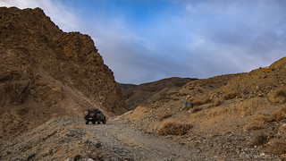
Up, up, up. I gained over 2000’ of elevation by the time I was done.

End of the road.
The road terminated at a few different spots, each of them clearly old mine sites. I have no idea what they were after here - probably gold - but while there wasn’t any equipment to explore, one of the sites did have a shaft that extended into the mountain a hundred feet or so, with a couple forks. I ventured in.
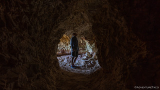
Some interesting colors on the ceiling.
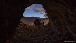
Headed back out.
My curiosity satisfied, I headed back down the hill and onto the highway I’d crossed a little more than an hour earlier. Turning south, I was soon passing through Hawthorne - filling up my tank and three 5-gallon Scepter jerry cans, as I didn’t expect access to fuel for the entire duration of my three-day trip! That - as you can imagine - was fine with me, and a few miles later I was headed up and over the Wassuk Range on Lucky Boy Pass Road.

Hawthorne is home to the Hawthorne Army Depot, the largest storage facility in the World. It stores reserve ammunitions to be used after the first 30 days of a major conflict.
Onto dirt and into the mountains.

Basin and Range of Nevada.
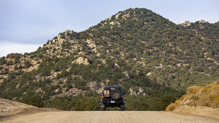
Lucky Boy Pass was very nicely graded - a side effect of several active mines in the area, and just as I reached the summit, what comes barreling my direction but the most I-mean-business-grader that I've ever seen on a back road. Clearly they want to keep this road smooth and comfy for the armies of truck drivers that frequent it each day.

Off the road? I beg to differ, I'm creating road.
My first real destination was a hot spring that I'd ferreted out from a couple photos I'd seen posted on the internet. Actually, I suppose that it'd be more accurate to say that I thought I'd ferreted it out - based on several hours of searching satellite imagery and matching up a few surrounding landmarks. Not to spoil the story, but it turns out that what I thought was the hot spring, wasn't. Anyway, we'll get there in a minute. First, I had a few roads to travel as I crossed the Mason Valley on NF-28, and then headed along the southern edge of the Singatse Range on ████████. It was a beautiful morning, and I stopped several times along this section of trail to snap a few photos of the wide open spaces and the fall colors that dotted the landscape.
I have organized this story a bit differently than most.
Some of the locations have little or no reporting on the internet and I feel they should remain that way or someone I respect has personally requested that I not share them; as such, locations have been redacted and/or not mentioned, I've used non-official names for local landmarks, and the order of the trip has been randomized.
Please, if you know the locations shown here, I encourage you to enjoy them as much as I did - and follow my lead by not mentioning their names or locations in order to keep them a little less well-known, and special.
For more on my approach, you can read Do you have a GPX for that?.

An old dugout, still in use today by the resident of a nearby house.

A dusting of snow in the distance on Mt. Patterson -a landmark that would not only become familiar, but that I also hoped to climb.

My first glimpse of fall in Mason Valley.

The colors of the cottonwoods reminded me of Colorado's aspens.
A few hours after I'd left camp, my stomach was rumbling and I arrived at an old homestead - one where I planned to eat the breakfast I'd put off on the shore of Walker Lake. As is often the case, the lure of exploration won out over the grumbling of my belly, and before pouring myself a bowl of Cheerios - which I really should have done first - I walked around the camp to check out the various buildings. There were six - or so - of different vintages. Clearly, an old stone cabin was the oldest, along with a couple of outbuildings. More recently, a cinder block cabin was constructed, and still contained a reasonable assortment of furniture and appliances - though of course, none of them were functional.

The original homestead.
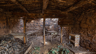
Now in a state of disrepair.

More modern accommodations.

Just to date myself a bit… I could fill this role at Cesars that I found in a newspaper ad on the kitchen counter. That is, had I not missed the application deadline by a measly 29 years. I'm becoming ancient.
Having explore the main area of the homestead, I listened to my body - screaming for food - and prepped a quick breakfast before wandering off to check out what looked like a tarp over a structure an eighth of a mile away. I was surprised when I got there to find that it wasn't just any tarp over just any structure. Rather, it was a brown tarp - for camouflage - over a rather modern and well-appointed white tent. I have no idea if this was being used by a squatter or rancher, but I approached cautiously and noisily to ensure that I didn't startle anyone who might be inside.
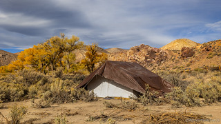
Well, that looks… a tad shady.

Don't mind me, just taking a photo of your secret hideout.
My invasion complete, I headed back to the Tacoma and did a quick wash-up of breakfast dishes and repacking of the stuff I'd gotten out of the back. My early exploration of the mining road near Walker Lake had set me back a bit from a schedule perspective and I was worried that I wouldn't have the time I needed to get through my entire itinerary. Back in the truck, my sights were now set on ██████ Hot Spring as I made my way through the valley.
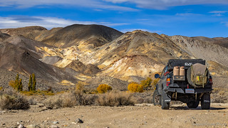
Colorful hills, speckled with sun, and partially blocked by a Tacoma.

There, that's better.

Ka-pow fall is here.
Soon, I found myself turning north onto █████████. This was the road that - I hoped - would lead me to the hot spring that I was sure I'd spotted via satellite. But first, there were a few important stops to make along the way. This road - like most of the roads around it, I'm sure - was quite clearly created for mining. Of what, I'm not certain, but gold would be my best guess - and so as I wound through canyon walls and down washes that exposed millennia of sedimentary layers, it wasn't all that surprising to stumble upon an old headframe.

On the prowl.

Layer upon layer. I thought it was cool how well-defined these layers were.

Below this headframe, a shaft extended some 30 feet or so.
A bit further along, lay the skeleton of an old bus. Perched semi-precariously on the hillside, the entire front was missing - making me wonder if it'd been used as a trailer rather than rolling here under its own power. Interestingly, it had skylights - not something I feel is common on busses of any era.

Rusting into oblivion.

Can you spot the evidence that - however the bus arrived in this location - it was once used living quarters?
At this point, I was withing spitting distance - well, almost - of where I expected to find warm water. Hopping back in the Tacoma, I found myself full of nervous energy - wondering if my sleuthing would yield the desired result. I pushed on the thousand feet or so to the spot I'd marked on my map.
There was no hot spring.
In fact, not only was there not hot spring, but I was looking at a bunch of dead reeds and shrubs, and quite honestly, I didn't understand how I could have possible associated this landscape with a sort-of-circular pool of water. An image from times past - wetter times, perhaps. 
Not sure what to do, I figured I might as well just drive to the end of the road - after-all, I'd made it all this way, and perhaps there'd be some more cool mining paraphernalia to look at. So that's what I did, winding my way along the creek (the █████████████████) for another mile or so. Along the way, several spur roads looked fun to explore, and with my soaking time now free, I figured I'd check them out on the way back.
But then - in a spot that I totally didn't expect - I saw it. I can't quite convey the sense of relief that I had at that moment. I mean sure, it was sort of just dumb luck at this point - because clearly the spot I'd hunted out was wrong - but I was still thrilled to have found this little oasis in the high desert.

The time and care that went into creating this pool is evident as soon as you see it.

A pleasant 102°F, or so.

Not a bad view from the pool.
In the end, I didn't soak long. It's not that I don’t like a good hot spring - especially one that's as clean as this one - but it's just not the same without someone else there with you to enjoy it. So, after five minutes or so, I toweled off and reclothed myself before heading for the Tacoma and the side roads I'd passed on my way down. The first one I explored wasn't too long and ended at an old mine camp. All that was left was a small shed and a bunch steel semi-buried in a mis-mash of tailings piles. I probably only spent 5 minutes here as well, before turning around and heading back the way I'd come.

When you build a mine shed this close to the wash, you must know it's not long for this world.

Heading back out, through a fun little dip in the road.
The second spur I took, I originally thought would be an alternate - and more difficult - route back to the main road I'd originally turned off of in order to find the hot springs. Following a wash into a canyon, the walls began to get tighter and tighter the further I pushed forward.

Heading up a small canyon.
As I continued on, it reminded me a bit of upper Echo Canyon in Death Valley, though the walls were certainly not as tall as those in Echo Canyon. After a half mile or so, the road curved sharply and at the same time the wash became stone rather than gravel - I'd arrived at a dry fall, again, much like upper Echo Canyon. It was at this point that I decided a prudent move would entail a bit of foot work, and so hopped out of the truck to check out the next few turns.
It was a good thing, too, because I'd have been able to make the first two or three turns through the narrow canyon, but I surely wasn't going to be climbing over the 36" diameter rocks on the fourth turn and backing out through the entire thing would have been a pain. Instead, I hoofed it back to the truck, and zoomed back out the way I'd come.
It wasn't lost on my that I'd been lucky - now twice in the course of an hour. And I'd soon find myself wondering if I'd used up all my luck for the trip, almost before it began...


Beautiful country! I have traveled through this area many times but never got to explore any of it. The life of a long haul trucker, you get to see a lot of country but don't get to explore much of it unless you just take the time to go out of your way to see more things.
I was coming up Hwy. 95 around 3:00 in the morning with my wife riding shotgun when in the distance I saw a train crossing the road (we were paralleling the tracks to the north), I started slowing down to a creep when my wife asked me why are you slowing down, I said for the train crossing the road ahead. She laughed and told me there wasn't any train and that it was time to find a wide spot and go to bed...lol...I agreed.
Safe Travels!
Thanks Kenny. 😁 And yeah, I'd say that it's time for some shut eye, hahaha! Safe travels to you as well - keep getting out there!
Hi, I've looked for the hot spring at Wilson Canyon (Yerington, NV) to no avail.
Well, I have to say, I almost missed it as well, and some of my favorite trips have ended up being ones where I was looking for something I never found! Keep hunting, and as I'm sure you already are, you'll make great memories!
Great story and pictures as always. RPG programmer? I didn't think that you were that old.
LOL, I wouldn't say that when I got to university that things were running "on the cutting edge." Mostly had to do with the professors in place at the time, and their love for "what they knew." There was many a program I ran, and printed off of our AS/400s the first couple of years, hahahaha!
Really is amazing how far things have come since then. Even those years in college, things changed rapidly. Fun story: I was lucky enough to meet Bill Gates in 1999, and I got to ask him if I should invest in @Home (an early cable internet provider). I got a very non-committal answer, though looking back now, it should have been a no-brainer. Full disclosure: I did invest a bit, and @Home later went bankrupt. Pretty sure their assets (and infrastructure) were what eventually became Comcast Xfinity.
In the early 80s my boss was speaking at a Microsoft conference and got to go to Bill Gates house. He described it as the world's largest bachelor pad, because it had almost no furnishings and they sat on large pillows.
My wife's nephew is a Bellevue police officer and pulled over a Porsche for making a left turn on a red arrow. The driver was Gates, and when he asked him for his license and registration, Bill pulled a stack of laminated cards with the license and registration along with the instructions on how to turn the lights on.
I first started working as a programmer for the City of Boise in 1980.
Verlan