
We had mostly clear skies and a it of breeze when we awoke in the morning. Our spot on the alluvial fan had worked out great, though not quite as remote as it appeared - the Morning Star Mine Road below us was significantly busier than we'd expected.

The sun out, nothing about the morning seemed out of the ordinary as we got breakfast underway and broke down the tent. It was only when we went to latch the swing-outs closed that we discovered something was amiss.


The u-bolt on the latch had broken, and no longer secured the swing-outs. we were lucky to have caught it before the entire latch failed, and as soon as we did, I knew we'd found the source of a rattling I'd heard since lunch time the previous day. At the time, I'd thought it was either the shovel, our water Jerry can, or the skid plate. I'd checked the bolts of the skid, and rearranged the bed in order to address the issue, and ultimately chalked the continued rattle up to things simply bouncing in the bed.
After a bit of thought, I realized that I could solve the problem - temporarily - by through-bolting the swing-outs together. This was only possible since I'd drilled a hole to do exactly this when at home - the latch for the swing-outs resulting in the truck being a bit too long to allow the garage door to close. (Yes, it's that close!) So I fished an M8 bolt and the requisite washers out of the OSK, and secured the swing-outs. It'd be inconvenient every time we needed to get into the bed, but it'd allow us to complete the trip.
More on this to follow in the trips Rig Review (which I'll post in a few days - sign up here if you don't want to miss it).

Our first stop for the morning was just a few more miles up the road we'd camped on, at the New Trail Mine. Really the access point to several mines, we climbed the rest of way to the base of the Ivanpah Mountains and started our exploration with the investigation of a couple cabins and work shed at the old mine camp.


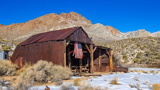
These cabins were in reasonably good condition, and after poking around a bit and doing our best to untangle the flag hanging from the shed, we pushed forward. This camp sits at the base of New Trail Canyon, and our goal for the morning was to tackle a 3-mile loop hike to the top - in the snow the entire time - exploring several old mines along the way.
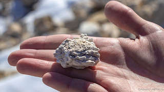
Almost immediately @mrs.turbodb found this amazing blue and green rock. Green copper patina we are familiar with, but neither of us had ever seen anything like the blue before in our lives!

The earliest mine here was the Bullion Mine - worked initially in the 1860's it produced silver-lead combo so valuable that the ore itself was shipped halfway around the world - to Wales - for processing. Its tunnels were worked for many decades - even as late as 1917 - continuing to produce lead-copper-silver ore the entire time. Up a couple of adjoining side canyons, our first stop was a large shaft at the end of a steep access road. It provided splendid views back down the canyon, but no real chance for exploration - a thick metal grate placed securely across our way.


It was at this point that we made a navigational error. We thought the main shaft for the Bullion Mine was further up the same - very steep and snow covered - wash that passed the tunnel we'd found, but after climbing to the top, we realized that it was actually in the adjoining canyon!  You win some, you lose some!
So, we headed back down and made our way to the next side canyon and wash. Even with snow covering much of the ground, we immediately we knew we were in the right place - concrete foundations, a large yellow metallic tipple, the remains of an old rusty trailer and loading dock, and a cableway leading to the mine shaft we thought we were climbing to, all there for our viewing pleasure. It all seemed very close to the bottom of the wash from our perspective - an indication that water flow through this area must have been reasonably low for a very long time.


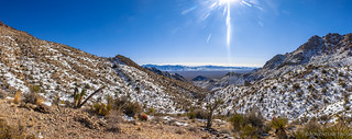
From the Bullion Mine, the hike up the New Trail Canyon wash really picked up. The wash itself transforms here from a wide sandy stroll, to a steep, rocky climb. Not that it bothered us - quite the contrary, it provided tons of visual interest and fun scrambles up old dry falls.


As we progressed, we - and especially @mrs.turbodb - were stopping frequently to admire the plethora of minerals that were present along the way. Clearly, this area was rich in copper, though its concentration here is surely increased by the dozens of tailings piles along the sides of the wash. When we stumbled upon these two large blue and green specimens, there was no way we were going to pass by without a photo.

Eventually we reached the head of the wash - still several hundred feet below a large tailings pile from the Revenue Copper Mine - and made a final push up the side of the canyon to reach its diggings.

The views from the top were splendiferous, and - I imagine - reasonably uncommon due to the recent weather. It'd been quite a climb to get to where we were, but it had definitely been worth it - and we still had the return trip to go!
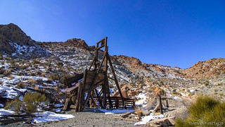
Before heading down, we took several minutes to climb around and look at the various mine shafts here - there were three of them, all uncovered given the relative difficulty of reaching them, and all of them were taking on water as the snow around them melted - the sound of it cascading down the walls seeming to go on forever. If exploring lost mines is your thing, walking up to the Revenue Copper Mine is high on my list of "worth it."
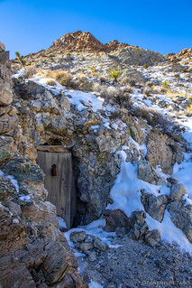
The climb now behind us, we headed back - but not the way we'd come. Instead of hiking down the wash in New Trail Canyon, we made our way down the old New Trail Mine Road. This would afford us the amazing valley views nearly the entire way, in addition to taking us by several more workings of the New Trail Mine, including a relatively intact headframe and a door into the mountainside that was inaccessible - due to erosion below it - and thus all-the-more intriguing!


The New Trail Mine Road eventually intersects the wash again, and we'd strategically parked the Tacoma at that intersection before heading off up the canyon. Back at the truck, and several miles of hiking behind us, we started talking about lunch. It was still a bit early, and @mrs.turbodb and I both had something we wanted to do first - she wanted to look at another of New Trail Mine's shafts, where the material (magnesite) apparently looked like cauliflower, and I wanted to check out a nearby wash where we would apparently find old fossilized sea ripples.

So that's exactly what we did - both were on the road back out, so we climbed into the truck and had a quick snack to hold us over for the next half hour or so. And that half hour was a huge success.


With that, we headed back down the alluvial fan we'd started up the prior evening, the views across the valley as majestic as ever. To make them last a little longer, we decided there was no better place than here to stop in the middle of the road, plop down our chairs, and enjoy lunch. So we did.

From New Trail Canyon, our next destination was fewer than 5 miles as the crow flies, but our route took us nearly 30 miles - such are the road systems through a wilderness area. It was - as always - no bother to us, and as we made our final turn into ███████████ on ████████████████, we were definitely looking forward to what lay ahead.
I have organized this story a bit differently than most.
Some of the locations have little or no reporting on the internet and I feel they should remain that way or someone I respect has personally requested that I not share them; as such, locations have been redacted and/or not mentioned, I've used non-official names for local landmarks, and the order of the trip has been randomized.
Please, if you know the locations shown here, I encourage you to enjoy them as much as I did - and follow my lead by not mentioning their names or locations in order to keep them a little less well-known, and special.
For more on my approach, you can read Do you have a GPX for that?.
Then - less than a quarter mile up the road - we were stopped in our tracks, literally. There, in front of us was something we were only slightly surprised to see - a rental RV, stuck in the soft sand.

Turns out the occupants were two couples from Germany, out exploring the American west. They were having a great time, but the snow a few days earlier had thrown a wrench in their plans. Unsure where to go, they'd eventually found this road and the mines to which it led, and decided it'd be fun to check out. However, when their front tires sunk into the sand just beyond the first wash, they'd quickly realized that they weren't in the right vehicle for this outing. They tried to turn around in the wash, and well - that didn't go so well.
Luckily for them, they'd only been stuck for ten minutes when we pulled up, and offered to help. This help was - as you can imagine - extremely graciously accepted, and we got to work assessing the situation.

In the end, there were really two options - either a tow strap or a winch would likely do the job, and I figured a winch was a little more controlled, and it turned out for me - slightly more accessible, so I pulled out the controller and various rigging bits and got everything set up for a pull.

Those RVs are heavy beasts, but with the winch sucking juice out of both batteries, and light feathering of the gas in the RV, the Germans were unstuck and on their way less than 10 minutes after we arrived. In all, a huge success!

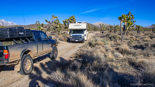
Gear stowed, we were on our way once again - climbing in elevation as we made our way into ███████████. Before long, the road got rockier and we reached the snow line. Chuckling to ourselves about how out of place the RV would have been here, we eventually reached the first stop on our loop - the ██████████████ Mine. The most extensive mine in this area, miners here worked a 356-foot deep shaft for copper over the course of many generations - evidenced by the construction and detritus left along the road.


Not much further up the road, an old school bus had seen better days. Judging by the wood stove and insulation I found inside, this was likely used as living quarters at one time. Now, the roof could use a little patching, and maybe some new windows.


From the ██████████████ Mine, the road winds up and down through the ███████ Mountains beautifully forested foothills, made all the more striking with the addition of snow. Just above 5000', we were in a transition zone between high desert and mountains with large Joshua Trees and junipers intermingled across the landscape.
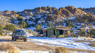
As mines such as the ██████████████ Mine were exhausted, would-be prospectors sometimes moved in to make claims on nearby ground - not so much to mine, but to enjoy free rent on government land - a quiet place to build a cabin and settle down for a while. ███████████ is just such a place. Hundreds of claims were filed within its small boundary and the road bypasses four of these camps, giving us the opportunity to visit these humble homes of reasonably modern desert hermits.
We first came to ██████████, where several structures were tied into a couple of RV trailers. It was unclear to me which came first, but the entire group were in state of major disrepair. Holes in the roofs, broken windows, and missing doors meant that both rodents and the weather could have a field day - and they were!


From ██████████, our next stop was the aptly named ██████████. Clearly, this camp was several steps above the first - its residents either better to-do, or simply more caring in their approach to their construction. A large white house was clearly abandoned for decades, but appeared to have been recently cleaned - perhaps the beginning of a restoration project. Nearby, old workshops, cabins, and unused mine equipment had seen better days, though it was clear from their contents that those days weren't all that long in the past.


Continuing along the loop, and without seeing anyone to this point, we were surprised as we pulled up to the next cabin that I'd marked on the map - there were other people here - a full-size Ford F-250 and a Jeep Rubicon were parked out front.
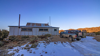
This was ████ Cabin, and was the residence of Robert R. ████, who first staked claims here in 1928. He and his descendants continued to live in or visit the cabin for many years, and photos of the cabin over that time attest to its general stability through the generations. Today it turns out that the cabin has been adopted and restored by a gentleman named Dave who just happened to be there with a couple of buddies when we pulled in!
How. Lucky. Were. We? 
Three things happened as we pulled in - first, of course, were greetings and the normal "where are you from, and where have you been?" types of questions that go along with any sort of meeting like this out in the wild. Then, it turned out that Dave recognized our license plate cover, and related that he'd recently read our 2018 trip to the Mojave Preserve! (so cool) Lastly - and by far most importantly - Dave gave us a tour of this splendid little cabin that he's put so much work into restoring. As he did, he related the history he's gathered and showed us the improvements he's made - restoring the cabin from a derilick building like the ones we'd seen earlier to one that is now rodent-proof and downright cozy.
We exchanged contact info, and Dave took our picture before sending us on our way to the final cabin in the loop. Dave - if you're reading this, thank you so much for opening your small bit of history to us!

The last cabin we stopped at, ███████ Cabin was - without a doubt - the most extensively restored of the bunch. It was surprising really, to have two restored cabins so close together, but with the beauty of ███████████, I can totally understand why people would choose this location.
Four times the size of the ████ Cabin, the interior was well-kept and extraordinarily clean for being in the middle of nowhere. As it was getting on in the afternoon, and feeling a bit like we were intruding on someones residence while they just happened to be "out of the house," our exploration here was quick relative to the prior camps, capped off with a few words added to the guest book.


I'd be remiss as well if I didn't mention the views. From ███████ Cabin, the entirety of ███████████ opened up to the north, the long rays of the afternoon perhaps the inspiration for the name of this beautiful valley!

With that, our exploration of ███████████ was complete - for now. In the future, this will be a great place to come spend more time, perhaps to hike to the crest of the ridge, looking down in all directions as the preserve stretches out in front of us. For now though, as we headed west, the sun low on the horizon, we had one more place to go. If we could make it before sundown.


Sensitive that we only had a few minutes, I pressed the skinny pedal as the truck skipped over the bumpy road. A left turn here, and a right turn there, and before long the miles separating us from the Evening Star Mine fell away. With mere seconds to spare, we caught the mine's headframe - the best in the preserve - in the longest rays of the day - just as the evening star set below the horizon.


Mined primarily in the 1940s, the Evening Star Mine produced tin, tungsten, and a little copper. Its headframe - standing at approximately 60' tall even today - is one of the largest historical mining structures in the preserve, and was definitely the largest that we would see on this excursion. The reason for its size was that it performed double duty - both as a headframe and also a mill. Large enough to process 10-15 tons of material per hour, it was likely overbuilt for the land on which it still stands.

The sun now below the horizon, it was time to find camp. We considered for a moment the possibility of camping here at the Evening Star Mine, but the snow on the ground, and the mountains to the east - which would result in a shady morning - quickly had us searching for lower ground as the orange horizon gleamed before us.

We decided to head north - back towards the Clark Mountains. The mountains where we'd started our adventure. Where, on our first day in the preserve, we'd been thoroughly trounced.
In the end, we arrived in the dark, part way to our destination. In Valley Wells, I'd marked a spot that turned out to be just perfect as it afforded us both a nice flat place to camp, morning sun, and historical ruins to explore when we awoke. Sometimes, you just get lucky!
As @mrs.turbodb warmed up dinner, I looked back to the south in the direction we'd come. In the distance, I-15, traffic flowing silently through the night, the moon and stars gleaming above.

On a trip we'd though might last less than a day, we'd eeked out nearly a week. The next day would be our last full day in the preserve, and we had no idea whether it'd be a complete bust or total success.
Like you, we'd just have to wait to find out!
The Whole Story


")

")


")

")
")


")
")
")

")


Great journal. Thank you for posting this. Photos are amazing as well.