
Having only gotten a few hours of shuteye before setting off on this adventure, the cool night air of western Montana - somewhere in the low 30s °F - made my cozy down comforters the perfect place to snuggle in for one of the best nights of sleep I've had in a long time. I'm not sure if I woke up at all through the night, only realizing when the sky was beginning to brighten that a thin layer of frost covered not only the exterior my tent, but also the top of my bedding.
Knowing that I still had a couple hours before my compatriots - Zane @Speedytech7 and Mike @Digiratus - would be making their way down to ground level, I did a little reading of the Jason Bourne series on my Kindle Paperwhite, and copied photos from the previous day from my camera to the laptop - so as to avoid losing them as I had a few months earlier (Curse of the Pahranagat).


Hearing feet on the ground a few minutes after the sun crested the tree line, I wrapped up whatever chapter I was reading and began the defrosting process by moving the tent into a patch of sunlight. It's amazing how quickly a little sun can dry things out, and after following my lead, Zane and I headed off to explore the nearby buildings.

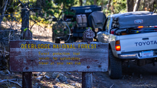
Turns out that the mine we'd camped at along Contract Mill Rd was the Huffman Copper Mine. There's not much - or any if you're me - information about this old place to be found on the internets, but I'm all ears if anyone has better search-fu than I do!
Wandering from ruin to ruin, the two most interesting were the spooky old bunkhouse I'd photographed the previous evening, and a fantastic machine shop that rivaled some museums. That's where Zane and I spent most of our time, completely unaware that a little further up the hill were the ruins of a rather large mill!


It was 11:00am by the time we got back to camp, broke everything down, and got on the trail. Our plan for the day was to drive from Granite - on the western flank of the Flint Creek Range - to Caruthers Lake on the eastern side. Our route - or at least the one that'd been mapped out on our GPS - suggested heading back down to Philipsburg before making our way through the mountains, but I had a "better" ideal.
You see, while searching for a camp site the previous evening, I'd noticed that the road from the Ruby Shaft at the top of Granite appeared to - eventually - meet up with our mapped route, so I suggested that we could save a bunch of miles by giving it a try. Those are - we all know - famous last words, but Mike and Zane were game, and we were out to explore, so up the mountain we climbed, my companions getting their first taste of the even-better-in-morning-light views.


It was 11:30am when we started out County Road 169 in search of an intersecting route that would - hopefully - usher us through the Flint Creek Range. This wasn't just any county road, however; from the get-go this road promised fun and excitement!
Having aired down before leaving camp, we immediately put our soft tires to use, bumping our way over basketball-size-and-larger rocks, climbing from 6,000 feet to 8,300 in a matter of a few miles. It was here that we stopped at some point - for photos and perhaps a short bathroom break - that Mike and I got to talking, and he mentioned that we were on a route that could take all day given our current speeds.
"It's only another mile or two to the road that Monte mapped," I replied, smiling.
Turns out I must have had the scale on my map zoomed out more than I thought - a couple miles turned into three, and then five, until 8.5 miles later, we finally reached the intersection with County Road 1592. It was lunch time, but I surely wasn't going to mention that to my buddies, because it doesn't take "until lunch" to travel just a mile or two. 


We spent most of those eight-and-a-half miles picking our way through the trees - no ridges, overlooks, or even reasonably open areas presenting themselves for photo stops - so when we happened on a cabin in the woods, there was no way we were just going to pass it by without stopping.

Initially I thought this was just a hunting cabin - and that we'd find it mostly empty - the owner carting their gear in and out each year as they set out to fill their tags. But, on opening the door, the entire thing was stuffed to the brim with furniture and supplies, all of it covered in several inches of rat feces. I shut the door quickly, and we didn't linger.

Having reached the summit of the trail just before the cabin, we continued on a mostly downhill trajectory, Mike calling out over the CB radio that my "one mile" estimate was woefully short - a detail that couldn't be argued (though I surely tried), despite the fact that there was nothing we could do about it.
The real question now was whether the trail we were going to intersect would be faster or slower than the one we currently found ourselves plodding along. Mike was pretty sure that it'd be a nice, graded, four-lane county road; I thought it looked an awful lot like that which we were already traveling. Only time would tell whose map tiles were more accurate. Until then, we picked our way down long-forgotten rocky roads, wondering if - at any point - we'd be forced to turn around entirely.


(Which we would never reach
 )
)A bit after 1:00pm when we turned east onto County Road 1592, our hopes for a high-speed thoroughfare were quickly trounced. The road here was similarly rough to the one we'd just completed, our only hope that it would improve as we got closer to Deer Lodge and civilization. Still, we held out hope for a lunch at Fisher Lake.
For the mile-and-a-half - or what I would later call a "quarter mile or so," we made slow but steady progress. Rocky and muddy, the trail wasn't anything that caused us any concern, our spongy tires and suspension absorbing the bumps in stride.

It was only as I approached a particularly steep section of trail that things really got interesting. Here, the trail was steep enough to get washed out by seasonal rains, and a narrow chute had developed at the top of the slope. The washout continued further down, but there a reasonably safe line - downhill at least - seemed more obvious, or at least, less off-camber.
Radioing back that I wanted to take a look, I - soon followed by Mike and Zane - hopped out of the truck to pick the best line through the initial obstacle, mentioning as I did, that, "if we make it down this, I sure hope we can make it through - with all the loose dirt, it'll be even harder coming back up!"

A line agreed upon - and with Zane spotting - I climbed back in the Tacoma and inched my way forward. The plan - should everything go as we expected - was to keep the driver side high on the chute and drop the passenger side down into the bottom, using the slider to keep from hitting the vertical wall of granite that would otherwise chew up our passenger side panels.
Initially, things went as planned. The driver side stayed high, the passenger side dropped down, and soon I was three-wheeling my way down the mountain.

Assured that the paneling on the passenger side didn't appear to be in any real danger, I pressed on, my slider grinding away on the granite for several feet before getting captured by a divot in the stone. No worries I figured - this is why I have an ARB front locker - I'd just pop on the front locker and pull myself through.
Except no.
Even with the front locked, the amount of weight pushing the slider into the granite was just too great, the Tacoma wouldn't budge. It was then that Zane noticed something else. The driver rear tire was back on the ground, but it wasn't happy.


With the rear still unlocked, I tried backing up. It was a big nope on that as well, the front tires unable to find purchase in the loose dirt at the bottom of the notch.

As someone who generally travels solo, I was very glad to have a couple buddies along at this point. Not that I would have gotten myself into this situation as a single vehicle - I know enough to generally avoid situations like this when I'm alone - and, I probably could have winched myself forward - even if it meant losing a bead or a bit of body damage - but it was reassuring to be able to work through the problem with some friends and know that we'd be able to pull me back out the way I'd come.
And so, naturally, that's what we did - Zane pulling his truck into position and winching me back out of the notch.

Extraction complete, it was time to evaluate our options. Ultimately, not knowing what else was in store for the remaining 15 miles of the route, we decided that the smart move - even with three vehicles - was to head back the way we'd come, stopping for lunch at a nearby opening in the trees, before making our way towards Georgetown, where a paved route would take us to Deer Lodge and the remainder of our adventure.
And so, after a leisurely meal of sandwiches and chocolate chip cookies, we headed west, eventually passing the intersection that'd delivered us from Granite, once again hoping that the road would get better as we made our way toward civilization; knowing that if it didn't, we'd be retracing our route from the morning, all the way to where we'd begun our day.
And that's when we found a really nice camp site.
It was only 3:00pm when the forest gave way to a broad meadow, a couple fire rings already nestled into the trees. Always on the lookout, Mike admitted that it was even a bit early for him, but that, "It's never too early to find camp." So, we did!

Finding camp early turned out to be fortuitous. To this point, we hadn't really figured out what our overall plan for the trip was going to be, but we knew that with Monte @Blackdog unable to join in his home state, and rain forecast in a couple of days, we probably needed to figure out (a) exactly what we wanted to do, (b) what we wanted to save until Monte could join, and (c) whether we wanted to suffer through the rain or run south - or home - for cover.

And so, after procuring a nearby standing dead tree for our campfire using Mike's extremely convenient battery-operated Milwaukee chainsaw, we sat down to figure out our plan, and to check out the area around camp with the flying camera.
It was as we stared down at the little screen on the DJI remote control that we realized that we could have used this new contraption earlier in the day - to scout the trail to the east - perhaps allowing us to continue on our way if no other obstacles presented themselves for the remainder of the route.


Our plan for the remainder of the trip sorted, we dug into a big bowl of Mike's guacamole as the campfire got started. Having eaten a reasonably late lunch - and having decided that we'd do a big group breakfast in the morning - guac, chips, and chocolate chip cookies would be our dinner of champions.
Not that such a dinner would ever be anything else.
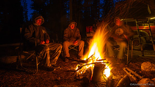
We hung out around the fire - toasty warm - until it consumed the entire tree we'd harvested. After a strange day on the trail, it was nice to fall back into our routine and a sense of normalcy. Not that the next day - or remainder of the trip - would be normal; this one had surprises around every bend.


Looks like you're putting that flying camera to good use! Nice images, and nice adventure. Love stumbling across old mines. If you find yourself south of Winnemucca, let me know and I'll give you directions to one that very few people make it to. The glass in the windows is even fully intact and there isn't a bullet hole to be seen.
Thanks Tom! Interestingly, we were just south of Winnemucca less than a week ago as part of Connecting the Dots in Nevada (Oct 2023) visiting a couple mines, and we're through there all the time on trips south to the desert in the winter.
Would love to hear about the mine you're thinking of.
Cheers!
D, some of the best pictures seen yet. This is a beautiful area!! keep the flying camera flying!!
Thanks Bill, glad you enjoyed them! Having a great time out and about - always so much new stuff to see. Amazing what these old timers would do for a little bit of the shiny stuff!
Thanks for the report and excellent pictures!
You should check out the books by Willie and Jeanne Worthy. Looks like you were on what they call the Fisher Lake Route, where they describe the difficult section you encountered.
Cool, thanks for the tip Curt, I'll definitely check out those books - always nice to find new sources for information! 👍
Dan, what is the slider you mention: "using the slider to keep from hitting the vertical wall of granite"? I'm amazed you kept air in that poor tortured tire!
Hey Anthony, sliders are the metal tubes that run along the sides of the Tacoma under the cab. They look sort of like steps, but they are structural - sort of like an additional frame rail - that protect the truck (body) from rocks or trees that it might otherwise hit on narrow or rocky trails.
The way they work is by allowing the truck to "slide" by (really, on/touching) those obstacles, which is why they are called sliders.
These - along with good tires - are really one of the most important bits for getting offroad (in my opinion), and here's where I fabricated and installed some on our old 4Runner. The Tacoma is the same, but I had them installed because I didn't know how to weld at the time, hahahaha!
hellO!
those wooden pipe are still used today. this one from my "hood" used to diverts water to small hydroelectrick plant.
Hello! That link doesn't work for me, but it's probably a photo of the wooden pipe. Amazing that you've still got them in service - most are long gone by now!
This is "the Chute" And it must be respected... I have a video of it...showing how steep it really is! The Road down dead ends... and shortly past the lake you would have had to come back out. It's worth the trip sometime!
Yes! I found out a bit more about this spot (and the ultimate destination at Fisher Lake) once we got back and I was at the computer again. Definitely a place I want to return, and I think it's doable with a slightly different line, and of course, knowing that it's an in-and-out, rather than a through route! Thanks for the heads up, and welcome! 👍
This blog post was great thank you! Trying to plan a trip with my buddy this weekend and doing a deep dig to see if we can do Caruthers Lake and then make a connection from Road 1592 to 169 and make it all the way through to Phillipsburg. That chute sure looks like a gnarly gatekeeper!!
Good pics! Thanks for sharing!
Glad you enjoyed it! After I got back, I did some more digging and talked to some folks who know the area well, since we were trying to run 1592 to connect with Caruthers Lake. Turns out that 1592 does not go all the way through (though you can get past the chute with a different line/tire size) to Fisher Lake. From there, the trail "is no more" so you have go come out the way you came in - westerly.
Ran a few more trails in the area that were fun as part of this trip (Half a Trip in Montana (Oct 2023)); hope you had a chance to check those out as well. 👍
That's sad but also thank you so much for the updated info so that we don't get all the way in from the East and have to turn back! Definitely checking out that next post too now thanks 🙂 We'll probably still end up trying for Caruthers Lake and see if we can figure out any other side adventures from your other post too! Thanks again!
We never got to Caruthers, so I'd love to head back and check it out. Have fun out there, lots of beautiful land - and old history - to explore!