
We didn't know it when we woke up, but today would be our last day of the trip. But, I'm obviously getting significantly ahead of myself, so let's take a step - or three - back.
Our amazing spot on the edge of the Grand Canyon, overlooking the Colorado River was just as spectacular when we woke up in the morning as it'd been the evening before. After a few gusts just before we climbed into the tent, I'd taken the hint and secured two full 5-gallon jerry cans of fuel to the ladder, eliminating any worry that a CVT-sandwich situation would occur if winds picked up during the night.
Turns out they didn't, but it was nice peace of mind.


As I'd hopped around rocks for a few minutes while @mrs.turbodb got breakfast ready for us, I noticed the pop-up camper parked in the valley just to our north. Between bites of Cheerios, I sort of chuckled to @mrs.turbodb that we'd won from the site perspective, and maybe they just wanted to avoid any risk of windy weather. Imagine my surprise when we finished breakfast and went for a short hike over to the area where they were camped, and discovered a second, enormous, side canyon. In fact, they were parked overlooking Whitmore Canyon! It seems, as may often be the case, the joke was on me!
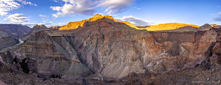
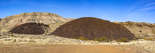
Our little stroll was quite pleasant, as we hopped from volcanic boulder to volcanic boulder along the edge of the canyon. It turns out that this spot was once the site of an enormous lava flow. In fact, at least 17 lava flows poured into the Grand Canyon around Whitmore Overlook over millions of years, damming the Colorado River and creating a temporary lake behind the plug. These lakes would take months or years to fill, completely drying the river downstream. Eventually, the river always found a path over or through the lava and violent rapids would once again rip apart the lava dam until it was entirely destroyed. In fact, giant boulders found downstream - as far as 100 miles - indicate that some of these failures were catastrophic events.
Even today, we could look across the canyon and see basalt high up on the opposite wall, the last remnants of the dam, now lost to history.

We considered hiking down to the river, and even started down the trail - but in the end, we decided to turn ourselves around to explore another area that we'd passed on our way in the previous afternoon: Pa's Pocket.

It was something like 8:15am real time when we pulled out of camp - or maybe 9:15am local time - and pointed ourselves north. This was surely the right direction to travel at this time of day, the sun working its way across the plateaus, illuminating the rainbow of colors that make up this amazing landscape.

The turn off to Pa's Pocket - signed as Paws Pocket by the National Park Service - was several miles back up the road and led east into what we'd realized the day before was a pocket of red-and-white sandstone, much like Whitney Pockets or Buffington Pockets.
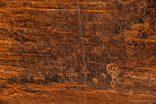
Suspecting that we'd be in for another petroglyph hunt, we soon found ourselves climbing up onto a plateau - a bit of a surprise, given our assumption that we'd be nestled within sandstone outcroppings. Not that we were complaining - not by a long shot.


Pa's Pocket it turns out, is not a place to discover ancient rock art - at least, not in our hour or so of glassing with binos. Nope, it's named for Pa, who had an old ranching cabin out here, and for the sandstone pockets that collect rainwater and snow melt to sustain plant and wildlife through the dry summer months.
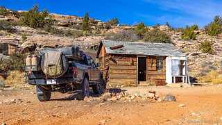
Pa's cabin (built in 1945 by Atwood and Ben Bundy and now owned by the Bar 10 Ranch) was a cool find, and the interior was in surprisingly good shape. Please, if you venture this way, do everything you can to ensure its longevity. Treat it with reverence, and remember that someone put a lot of time and effort into this cabin. If that's not enough, perhaps the fact that the road to Whitmore Overlook itself is on the same private land as the cabin - and that the Bar 10 Ranch is kind enough to keep that road open for us to enjoy - will help visitors make responsible decisions.


Having spent a couple hours in the area, we found ourselves wondering where the road ultimately led, but without enough time to figure it out. Into the wild of the plateau, it turns out - or at least appears - according to satellite imagery I found upon our return home. A great place to return and explore on a future trip!
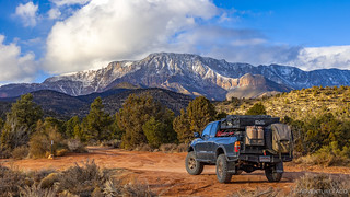
We, on the other hand, headed north - our fuel situation now such that I had to add a jerry can of adventure fluid before we reached a filling station in St. George, Utah. Not that we had bad views along the way as we stopped to feed the Tacoma.


In addition to Tacoma juice, we filled our bellies as well, before making our way to the north end of St. George and Snow Canyon State Park. We did this without stopping at a gas station, figuring that we'd do that when we were done in the area, giving us as much fuel as possible for whatever was next. A quick stop at the overlook whet our appetite for the hike we had planned, if only we could find a way to access it.

You see, as with our hike up █████████ Canyon in the Red Rock Canyon National Conservation Area outside of Las Vegas, civilization has encroached on Snow Canyon, rendering many of the access points to our trail inaccessible. Unable to find our way without help, we headed to the visitor center to ask for directions. Lucky for us, we found a helpful ranger who gave us several tips - while at the same time urging us to visit more of the park - and we set off with high hopes that we'd find the slot canyon and petroglyphs we were after!
We'd end up joining the 10-mile long ████ trail somewhere near the middle, saving ourselves several miles of hiking to reach our destination. If I were to do it again, I think we actually enjoyed the trail more than the small slot and petroglyphs, so I'd probably just hike the whole thing.


Light snow began to fall as we made our way north, but a partly cloudy sky meant we didn't have to worry that it was going to stick around very long. This trail was not heavily travelled, and @mrs.turbodb remarked that it was more like route finding - trail markers spaced just close enough to see from each other, but requiring hopping and squeezing over the orange terrain in order to achieve the next objective.
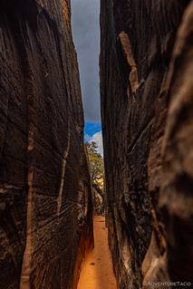
And then, we found the crevice we were looking for. Off of the main trail and its opening camouflaged by trees, we almost missed this photogenic side canyon with an integral tree and well-weathered petroglyphs.


Our curiosity of Snow Canyon and the ████ trail far from satisfied, we decided the right move at this point was to just keep going - exploring more of this wonderful trail. And so we continued - rock hopping and scrambling - for another hour or two, like kids in a candy store as we took in our surroundings. There were - perhaps predictably - more petroglyphs along the way.


Eventually, the snow picked up a bit more; nothing that was at risk of sticking, but it brought along cooler temperatures and got us to head back the way we'd come, toward the comfort of the Tacoma. With a sense of where we were headed, we took a slightly different route on the way back, the sights once again new and captivating.


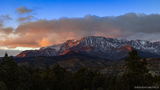
We arrived at the truck with just over three hours until sunset. Snow Canyon had been the last item on my itinerary for the day, and I had no idea where we'd be camping. That turned out to be fortuitous, as I had a desire to visit Yant Flat but nowhere to fit it into our schedule. Now, with a few hours of light, I knew we could head into the shadow of the Pine Valley Mountains to find camp, allowing us to explore the photogenic flats first thing in the morning.
The road signs to Yant Flat were encouraging and ominous at the same time: "Impassable when wet." Good, because maybe that would mean fewer people; ominous because of the dusting of snow we'd had through the day. The weather report suggested clearing however, and we pushed on - pretty sure that we'd have enough fuel to get us up into the mountains and back down to St. George the next morning.
From the trailhead - where we planned to camp since there was no one else around - it was just over a half mile hike to the flats. With an 90 minutes before sundown, we decided we'd hike it once in the evening to get our timing down, and then again in the morning for sunrise! It's not like we had anything better to do!
Well, after an easy meander, we found ourselves looking over the colorful sandstone of Yant Flat about half an hour before sunset, and with the sun behind the clouds that were crowding the horizon. Hoping they would clear, I convinced @mrs.turbodb to wait (not a hard task) and we looked out over the landscape until - to our delight - the sun dipped below the clouds!

The color didn't last long - the sun always seems to move faster when it's on either horizon - and soon we were headed back up the trail as the colorful light danced across the taller mountains and sky.

I'm not sure how the discussion started, but as we walked, @mrs.turbodb asked me what I would do if I were on the trip alone. "I'd probably drive home through the night," I said - sure that we were still going to be setting up camp and eating dinner when we got back to the Tacoma. "Let's do that then," she said. Some more back and forth, and she convinced me that as long as I was OK driving, it probably was a good idea. I mean, it would allow us to drive with essentially no traffic, would ensure that the tent would come home dry, and would get us home an entire day earlier than we'd planned.
So, I put in our last 5 gallons of fuel - enough to get us to the wee town of Cedar City - and we set off to the north. Our route would take us through Salt Lake City and Boise before looping back to Oregon and our home state of Washington.

And - shock of all shocks - we'd do the entire thing with a headwind. Go figure! 


 - Mid-Winter #4")


Wow! Fantastic photos. You had a great spot in the first photo. I saw you two at the the 9 O'Clock position.
Sorry that the trip ended so soon, at least for those of us ‘tagging along’. Some very nice photos along the way.
So glad you enjoyed it Lapsley! There will be another one along soon ?, and I'd love to have you tag along that one as well. If you aren't already, you can get emails when I post new stories, here: https://adventuretaco.com/subscribe/ ?
Great trip guys! Fantastic photos as usual. Great job!
--Paul
Thanks Paul!
It is always a pleasure to follow along on your trips. They are great motivation to get out there and explore!
Thanks Keith, it's always great to hear when you enjoy them!