
With winter wearing on here in the gloomy pacific northwest, I suggested to @mrs.turbodb that perhaps we should take after the school system and celebrate our own Mid-Winter Break. Somewhere with sun, preferably. Honestly, I was a little surprised at how open to that idea she was, and quickly realized that I was behind the eight ball to figure out a plan that would keep us busy for a week! There are worse problems to have, obviously.
I considered the obvious options - heading down to Death Valley, which we both love. Spending some more time in the Mojave Preserve or venturing to Joshua Tree National Park for the first time. Ultimately however, I settled on an idea that I knew we'd both very much enjoy - we'd head back to the eastern Mojave. We'd been there only once - almost exactly a year earlier - and since then I'd found dozens of additional destinations that I'd missed on our first pass through. Plus, I'd get a second shot at taking her to Whitmore Overlook on the edge of the Grand Canyon - still one of the most dramatic views I've ever seen. It was perfect.
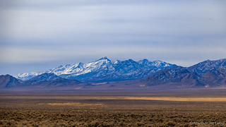
Creatures of habit, we got started early on a Wednesday morning, many hours of pavement in front of us before we'd reach our destination - just outside of Wells, Nevada - for the night. It was a reasonably pleasant drive in good weather, except for the strong headwind. We weren't setting any gas mileage records on this leg of the trip!
Now, most of our winter trips to places like Death Valley have us passing through Wells with many more hours to drive, so we were quite happy to arrive sometime after 10:00pm. The first place I'd decided we should check out was the ghost town of Metropolis, and I figured that camping there would allow us easy access to exploration in the morning.
@mrs.turbodb gave me only a small sideways glance due to the sketchiness of the area as we arrived, and soon the tent was setup and we were cozy under the covers, the skies clear but patches of snow and ice still covering the ground. I set my alarm for "before sunrise," and slept quite soundly through the night.

Metropolis was established in 1910 by Harry Pierce as an agricultural community. In 1912 a rail spur was built for services as the population Grew to 700. A request for water from the nearby Bishop Creek Dam, built from 6.5 million brick remnants of the 1906 San Francisco earthquake, was denied thus dooming the town. Lack of water, a typhoid epidemic, rabbits and mormon crickets led to the town's demise. The town ultimately died in the 1940's when the last school and post office closed.
There's not much left of Metropolis today, with only the foundation of an old hotel and the entryway of the Lincoln School still standing.


It took longer to eat breakfast than it did to explore Metropolis, which has clearly seen better days - most surfaces decorated with a variety of sprayed paints. A little disappointed that none of the vandalism was Superman themed, we climbed back in the truck and pointed ourselves south again - now travelling along US-93, the Great Basin Highway.

We passed the time listening to podcasts and the radio, the sound deadening of the cab a godsend given the headwinds that were even stronger than the day before. The winds here usually blow out of the north, so you can imagine how happy I was to encounter exactly the opposite.
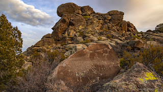
Some four hours later, we found ourselves on NV-318 at the turn-off to the White River Narrows, in the Basin and Range National Monument. There are several concentrations of petroglyphs throughout this part of Nevada, and our plan was to visit as several of them over the course of the next couple days.

One of the things we discovered was that Lincoln County and the BLM had placed visitor logs and descriptive guides at each of the petroglyph sites, giving visitors who stumble upon these gems - instead of simply racing by on the freeway - a bit more context as they immerse themselves in the hunt for rock art.
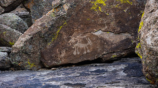
The first site we came upon was on the back side of some well patinaed rocks right next to the road.

There wasn't a lot here compared to some of the other sites, though we did find this little guy, who seems quite happy to me - almost as though he's dancing.

Nearby, we found our first example of what historians think may be imagery of a fence used by Native Americans to herd or trap animals in the narrow canyons found in the area. Of course, we have no idea what the imagery really means, as there are additional theories that I'll touch on in a moment.


At the third site we visited, the only etching on the entire rock was a horizontal line with several vertical lines intersecting it. Another fence? Perhaps, but over the years, another theory has been floated as well - that this could be some sort of solstice timing device.

You see, as the sun moves across the sky on the summer solstice (June 20 or 21 depending on the year), a shadow protrudes down across the rock face towards the calendar fence. At the same time, a shadow from the main cliff on the left moves to the right across the rock face shading the fence pickets one after another. At exactly the solstice, the shadow-dagger from above stabs the fence just as the right-moving shadow merges with the shadow-dagger to form a single shadow.
Clearly we timed our visit incorrectly, since the entire thing was shrouded in shadow while we were there.
By now it was nearing 1:00pm and both of us were getting hungry. We agreed that we'd eat lunch at the next petroglyph site- not too much further up the road. When we arrived, @mrs.turbodb got busy assembling sandwiches, and I set out to find the three panels that made up the site.

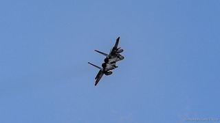
All of a sudden, a low-ish flying F-15 came roaring over the narrows wall. I got the camera up as quickly as I could, but not really quickly enough.

Just as I was starting to bring the camera down, I caught something moving in my peripheral vision. A wingman, of course. And then, to both my - and @mrs.turbodb's, who was watching from her vantage point - delight, the second F-15 proceeded to do a barrel roll as he fired his afterburners and climbed up after his buddy.

It was pretty exciting to see this - bringing back memories for me of my time in Death Valley's Hidden Dunes. I'd had more time to see and prepare for the planes that flew through on that day, and I'd had a better angle with the light, but this was pretty damn cool as well. Plus, I was using a new camera setup this time, and was impressed with its ability to autofocus as I tried to quickly track the plane as it screamed across the sky.


We kept our eyes peeled as we quickly plowed tuna sandwiches and potato chips into our mouths, but alas - no more low-flying planes graced us in that narrow valley. We got the bed of the Tacoma put back together, and resumed our exploration of petroglyphs.

It turns out that the last set of panels we'd discover in the White River Narrows were - by far - the best. This was somewhat surprising to me as they weren't the hardest to get to, or most remote. In fact, I'd say they were quite the opposite. Still, they were northerly facing, so I suppose that helped to protect them from sunlight and weather more than many of the rest.


We'd spent only a little under two hours at the White River Narrows site, but boy, it'd been a tremendous start to the rock art we'd see on the trip! As we headed back out the way we'd come - which I should note was not the plan, as I'd thought that the road was a loop road back to the highway - I filled @mrs.turbodb in on our next attraction: the Mt. Irish petroglyph site!
This is one that I'd really been looking forward to, because it contains several instances of a humanoid figure known as Pahranagat Man. Unique to the Pahranagat Valley, the spatial placement of this figure is thought to be representative of a "power being" of perhaps a spiritual or supernatural nature, protecting and watching over the areas in which it is etched.
Anyway, even now my excitement is getting the better of me. First we had to get to Mt. Irish - which meant another drive south through the tiny town of Hiko, then we had to hope that the whole place wasn't covered in snow - the elevation of just over 7,200' reasonably high for this time of year.


The Mt. Irish area has many concentrations of rock art, and though I knew of several, I'm sure there are dozens more that could be discovered - perhaps for the first time - over the course of weeks or months, by exploring the rocky mountainsides. Our first stop - at Echo Rock - gave us just a little taste of what was to come.


From Echo rock, it wasn't far to Piute Rock, where there were several intriguing glyphs. Even without a Pahranagat Man, this might have been my favorite collection of the bunch.


Next, we headed to Shaman Knob and Shaman Hill. Here is where we'd find the highest concentration of Pahranagat figures, though they'd be dwarfed by the enormous numbers of bighorn sheep carefully carved into the stone.


There were several dozen panels to explore on Shaman Knob and Shaman Hill, and I think we visited most - but not all - of them. You see, one of the little guides - which existed here, just like they had at the White River Narrows - suggested that there were another set of panels that I'd not known about, down a road that looked like it might be a fun drive as well. So, with not much time before sunset, we headed out that direction - the lure of a dancing sheep, coyote, and life-sized bighorn, too much for us to resist.


Reasonably quickly, we found the little dancing sheep and sneaky coyote.

It took a bit more searching for us to find the life sized bighorn. That was just fine, because along the way there were several other panels to keep our interest piqued, and remind us that we could spend days, weeks, or months here and constantly find new things. And then, around a corner, we found it.
By this time, it was getting close to sunset, and we still didn't know where we were going to setup the tent for the evening. Also, @mrs.turbodb had a phone meeting that she needed to attend, and though we knew that if necessary we could head back into Hiko where there was good cell coverage, the ideal situation would be to find a camp site with service.

As it turned out, when we got back to the truck at Shaman Knob, we found a fire ring nearby and - when we held our phones just so - a bar or two of LTE. Perfecto!
We pulled the truck into a spot near the fire ring, and a bit sheltered from the now northerly wind - of course it was out of the north when we weren't driving south - and prepped a delicious dinner of my famous tacorittos with guacamole. So. Good.
We didn't get much of a display in the sky - there were just too many clouds on the horizon - but it was clear that the military was flying much later into the evening for some reason, and we'd continue to hear them even after dark as they buzzed around, kicking on their afterburners and breaking the sound barrier a time or two - albeit at higher elevations.

It'd been a great start to the trip, and we were even a little ahead of schedule. I'd only planned to investigate about half of the Mt. Irish petroglyphs on the first day of our trip, but we'd seen all the sites I'd planned, and more.
And that would turn out to be a good thing come morning - because as well laid as my plans had been, there was an idea kicking around in the back of my head. An idea that would either make me a genius or prove that I was crazy...


 - Mid-Winter #4")


Another home run...! You guys are amazing. I still can't believe the lengths of driving you do in that Tacoma. This blog is the best of the internet. many thanks! Paul
Wow, thanks Paul! That put a huge smile on my face. Cheers! ?
I cannot hike like I use to due to age and condition. However, these photos and narration was almost as good as being there. thank you so much. I cannot wait to show this to my family as I raised them to be rock,landscape hounds like myself. I am trying to figure where it all is and how to get there and if so maybe I can see some of it. Wrote down enough info to look it up. Great pics...THANK YOU!
Jeannie - so glad you enjoyed the story and that it brought back memories for you! I hope your family enjoys it as well, and it would be super cool if you could get out to enjoy some of it. Stay safe out there, and young at heart!
Amazing photos and terrific travelogue commentary. Well done!
Thanks Dave, glad you enjoyed it!
Cool beans. This site / area is on my plans come Spring.
Cool, have fun out there! I'd love to hear if you find additional places nearby/in NV, as I'm always looking for reasons to return.