
One of the things we've learned about running a Backcountry Discovery Route (BDR) is that trying to time a stage to a day - where the day ends at the designated end (and thus beginning) of a stage - is a bad idea, at least when you're trying to camp. This is obvious once it's realized, and it makes total sense for the dual-sport bikes that BDRs are designed for, since they often use towns as places to find a roof for the night, but for a truck - where the sleeping arrangements are in the bed - it's better to be somewhere in the middle of a stage when night falls.
One of the things we'd done differently on this BDR, compared to others that we've run, was opting to eat lunches in town making more room in the fridge for a variety of dinners. The idea was that we'd reach the end (and thus beginning) of a stage right around lunch time, enjoy some local fare, and then continue on until sunset - ideally on the top of a ridge in the middle of nowhere - for dinner and camp.
The problem - as we rolled out of Lake City just after 10:30am - was that we'd arrived too early, and we'd eaten breakfast too late. In fact, the fact that we were moving so quickly through the stages meant that our lunch plan might be a bust entirely, since it relied on the fact that each stage would consistently take a day to complete.
Luckily, we had plenty of snacks, so we climbed up out of town - along CO-149 to Slumgullion Pass - as @mrs.turbodb read about the Slumgullion Earthflow from the Roadside Geology of Colorado.
The first slide happened nearly 700 years ago, damming the Lake Fork of the Gunnison and creating Lake San Cristobal. Then, about 300 years ago, a second flow started creeping downhill on top of the first. That flow is still moving today - at about 20 feet per year - like a glacier made of mud. We pulled off at Windy Point to stretch our legs and stare out over the twisted forest.

The view from Slumgullion Pass, looking back toward Lake City. Red Mountain there, shining bright.
Right from the get-go, it was obvious that Stage 3 would be a much different experience than the first two stages. Having worked our way up to Slumgullion Pass, we found ourselves on alpine plateaus, working our way through stands of fir and aspen, along creek beds, and through fields of sage. It was - except for the elevation - reminiscent of the high desert plains we often find ourselves in as we explore portions of Nevada and Eastern Oregon.

I see you trying to hide there, volcanic protrusion.

This section of trail - along Cebolla and Pasture Creeks - felt a lot like the Owyhee, but for the trees.

Oh, to have been here just six weeks later. The colors must be fantastic!

More nice geology along the way.
In addition to the terrain change, the roads were also significantly smoother - at least for the time being - than we'd become accustomed to as we traversed the San Juan Mountains. This meant that we were making quick time, and that @mrs.turbodb was able to squeeze in her pre-lunch nap as I cruised over Los Pinos Pass (10, 514') at speeds suggesting we might wrap up yet another stage of the BDR before we knew it.
Or maybe not. As we sped toward US-50, the GPS on the dash signaled good news: an "Expert Alternate" leg of the BDR was just ahead, hopefully giving us a bit more to look at and enjoy!

Why is this segment the expert alternate? Because there are cows to dodge, of course!
This little alternate segment was only six miles long, but it promised some fantastic views of Prosser Rock, should one know what they are looking for. We - though two - are not of the class who know what they are looking for, and so almost immediately, we thought that a rocky dome that the road seemed to climb toward was our goal for this little detour.

This - Razer Creek Dome - is not Prosser Rock, which we'd discover shortly.
As the road turned, well before what we thought at the time was Prossor Rock, several snarky comments - along the lines of "Another swing and a miss for the BDR planners; close but missed another cool sight," could be heard in the cab of the Tacoma. Our mood wasn't improved by the condition of the road, the surface covered in softball-sized rocks; the worst size for comfort.
Hoping now to just tick away the last five miles of the alternate track, we bumped our way through the sage-covered hillside, oblivious to the beauty that even places like this hold. And then, cresting a small fold in the terrain, there was the real reason for our suffering. The real Prosser Rock.

Now who's feels like a dummy?

Prosser Rock view.
For the last couple of hours - and maybe even since leaving Lake City, we'd been racing a storm that was blowing in from the west. It wasn't anything to worry about - a bit of rain, plus some lightning and thunder would simply add interest to this leg of the journey - and we wondered if it'd catch us as our speeds slowed on the bumpy road. Somehow, it never did.

Time to get going!
It was right around 3:00pm when we crossed Highway 50 - The Loneliest Road in America - at a place that most definitely lived up to its nickname. It was a non-event in every sense of the word, the well-graded county roads more heavily trafficked than the highway.

With roads like this, we quickly put distance between ourselves and the storm. For now.
Heading north toward Cumberland Pass and Tin Cup, I mentioned that these were places I'd visited with Mike @Digiratus and Monte @Blackdawg on our Redhead Down trip through Colorado, several years earlier. In fact, it turned out that much of this route was vaguely familiar to the route Monte had planned at the time, making us wonder if perhaps he'd based it loosely on the BDR track.
No matter, this was terrific terrain to travel, and we found ourselves stopping regularly to admire the view of the Rocky Mountains' Sawatch Range as we quickly gained elevation.

Not the saddle we were shooting for, but striking nonetheless!

Red ridges.
It was at the top of Cumberland Pass that things got a little dicey. The storm had once again gained ground as our route necessitated slower speeds and several switchbacks, and as we reached the saddle, we were greeted by two throngs of UTVs. Wanting a few minutes of solitude - for a quick bathroom break and to launch our little buddy for an aerial view - I pointed the Tacoma toward a trail that ran along the ridge and to the summit of nearby Napolean Mountain.
This was no trouble in itself - though the road was a little rockier than I suppose my passenger would have preferred - but as it got steeper and steeper, I could see that she was not thrilled with the rate of elevation gain we were experiencing. The hill climb - let's just call it what it was - no real trouble for the Tacoma, but it was also entirely unnecessary in order to accomplish our goals, so I slowly backed us down to a more reasonable pitch, and eventually back onto the road where we continued on toward Tin Cup.

Down we go.
Founded in 1878 when lode deposits were discovered in the area, Tin Cup was originally named Virginia City and by the 1880 census, the town had a population of 1,495. However, confusion with Virginia City, Nevada, and Virginia City, Montana, caused the residents to change the name to Tin Cup, after prospector Jim Taylor panned some gold from Willow Creek, and carried it back to camp in a tin cup.
Tin Cup is a small, quaint town. Its roads - including main street - are dirt.
For many years, Tin Cup was a violent place. Town marshal Harry Rivers died in a gunfight in 1882, and marshal Andy Jameson was shot to death in 1883. The town population declined as the mines were exhausted and the post office closed in 1918, the last year any town elections were held.

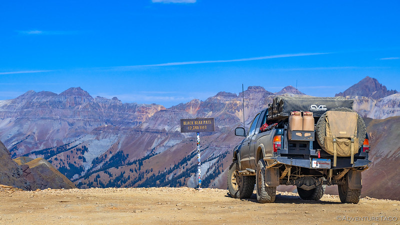
It was 5:15pm as we pushed the speed limit - a whopping 10 mph - through Tin Cup , and that meant we had a decision to make. As had been the case on previous legs of this BDR, Stage 3 had gone quickly - we had only one more pass between us and the end of the stage at Buena Vista - and we needed to decide if we were going to look for somewhere to camp nearby - perhaps near Taylor Park Reservoir - or if we would push to the end of the stage and then a bit further before settling down for the night.
This decision was complicated by the fact that there was a hot spring that @mrs.turbodb wanted to stop at just before reaching Buena Vista - an activity that would be nice, had we a bit more time to enjoy it.
This time - in contrast to our decision on top of Hurricane Pass in the Alpine Loop - we decided that we should push on. "We'll look for somewhere to camp near the top of Cottonwood Pass," I suggested, not even thinking that it might be a paved highway at that point.

Just outside of Tin Cup, we were shocked by the 100-foot long, 2-foot deep water crossing we encountered.

Even at this point, things were looking good for a high-elevation camp.
We turned onto pavement - Gunnison County Road 209 - four minutes before 6:00pm. As we did, we looked at each other and I asked, "Does this run all the way to Buena Vista?"
"Yep," @mrs.turbodb said.
"Dang," I replied.
That was the point that we both knew that we needed to come up with a new plan for camping, but we decided to enjoy the ascent - which would take us to the top of the Continental Divide - before coming up with ideas. Or at least, I figured the idea I had could wait until we were on our way down.

Every pass is more fun on dirt, but I suppose it's nice to have one or two for the Honda Civics.

Cottonwood Pass view.

We're headed to the Atlantic side!

Windy way down.
As we cruised down the eastern flank of the Rocky Mountains, I knew it was the perfect time to take a detour. As is common on a BDR, the route was designed to get us from point A to point B, but not necessarily by seeing the coolest things along the way. There are many reasons for that - which I won't get into here - but in this case, just south of the stage end at Buena Vista, there was a 14,000-foot-tall peak - Mt. Antero - that I'd been trying to reach the top of for more than five years. Defeated the first time by a truck - not mine - that broke down, and the second by a snow drift over the road that resulted in darkness setting in before we could hike all the way to the top, I hoped that my third time up the mountain would be a success.
After proposing my plan to @mrs.turbodb - that we push onward through Buena Vista, and upward to a camp site halfway up the flank of Mt. Antero before calling it a night - she reluctantly agreed. My plan would mean no pit stop at the hot springs she'd wanted to visit, but we left the possibility open that we could find another one the following day as we worked our way further along the BDR.

End of the stage, but on to the good stuff!
And so, as darkness fell, we raced our way to 10,880 feet, where we'd find a camp in the shadow of 13- and 14,000-foot summits. The following morning, we'd take a brief intermission from the BDR to finally get ourselves to the top of Antero. After pitching the tent as rain began to fall, we climbed into the Tacoma for dinner as darkness fell and gunshots rang through the valley. Yay?
The Whole Story


That whole area around Lake City is beautiful, but it is nowhere near Highway 50
Somehow, I must’ve misread your script
Yes, camping is a little tough around that area out of Tincup and Buena Vista
When we did the CDT trail, we camped at Taylor Reservoir. One of the few places on their trip that we had to pay for a campground.
There was a good bit of driving between Lake City and US-50 up near Parlin, but the roads between the two points were in great shape, so there weren't a lot of photos in the few hours that it took to cover that section of the route. Sort of why I titled this one the way I did, lol.
I've camped near Taylor Reservoir before (technically, in Taylor Park), but we definitely didn't have to pay. Was a nice camp, though definitely a more crowded spot with all the recreation that goes on there!
Welcome to Chaffee County!
Thanks!
Beautiful, God's country!
I'm surprised you didn't keep going through Tin Cup and go over Tin Cup Pass and come down into St. Elmo! That way's a lot more fun!
I know, right?! That's part of why I titled this story the way I did, lol!
Tin Cup Pass was nice when we ran it several years ago, so at least I got to experience it then!
One thing with BDRs is that we generally try to stick to the routes, just because we want to experience it the way the creators intended it. Plus, it's nice for others - who might read these reports for inspiration or reconnaissance - to get a sense for the actual BDR, rather than having to filter out our bastardized version of it.
Don't worry though, we didn't skip all the good side-routes along this stretch of the BDR; stay tuned for an "intermission" that was several trips in the making!